

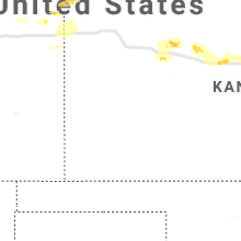
Hail Map for Saturday, August 17, 2019

Number of Impacted Households on 8/17/2019
0
Impacted by 1" or Larger Hail
0
Impacted by 1.75" or Larger Hail
0
Impacted by 2.5" or Larger Hail
Square Miles of Populated Area Impacted on 8/17/2019
0
Impacted by 1" or Larger Hail
0
Impacted by 1.75" or Larger Hail
0
Impacted by 2.5" or Larger Hail


Cities Most Affected by Hail Storms of 8/17/2019
| Hail Size | Demographics of Zip Codes Affected | ||||||
|---|---|---|---|---|---|---|---|
| City | Count | Average | Largest | Pop Density | House Value | Income | Age |
| Deadwood, SD | 2 | 1.75 | 1.75 | 18 | $78k | $32.3k | 48.5 |
| Lake Andes, SD | 1 | 2.00 | 2.00 | 5 | $32k | $20.4k | 31.6 |
| White River, SD | 1 | 2.00 | 2.00 | 0 | $28k | $24.4k | 35.2 |
| Presho, SD | 1 | 1.75 | 1.75 | 0 | $38k | $30.3k | 47.6 |
| Newcastle, WY | 1 | 1.75 | 1.75 | 2 | $67k | $32.8k | 42.4 |
| Saint Francis, KS | 1 | 1.75 | 1.75 | 2 | $50k | $31.4k | 51.1 |
| El Dorado, KS | 1 | 1.75 | 1.75 | 63 | $66k | $35.2k | 35.5 |
| Ortonville, MN | 1 | 1.75 | 1.75 | 20 | $48k | $31.3k | 49.2 |
| Kimball, SD | 1 | 1.75 | 1.75 | 2 | $40k | $31.5k | 39.0 |
Hail and Wind Damage Spotted on 8/17/2019
Filter by Report Type:Hail ReportsWind Reports
States Impacted
Missouri, Kansas, Illinois, Indiana, South Dakota, New York, Maryland, Pennsylvania, Ohio, North Carolina, Virginia, Wyoming, Texas, North Dakota, Vermont, South Carolina, New Hampshire, Oklahoma, Minnesota, Iowa, ColoradoMissouri
| Local Time | Report Details |
|---|---|
| 7:04 AM CDT | Quarter sized hail reported near Saint Louis, MO, 13.2 miles W of Saint Louis, MO, public photo sent in estimating near one inch hail. |
Kansas
| Local Time | Report Details |
|---|---|
| 7:28 AM CDT | Delayed report. widespread wind damage across town. numerous trees...power poles and power lines down. some trees and tree limbs fell on cars and fences. time estimated in montgomery county KS, 28.9 miles S of Chanute, KS |
| 3:45 PM MDT | Golf Ball sized hail reported near Saint Francis, KS, 42.7 miles ESE of Yuma, CO, up to golf ball sized hail. |
| 5:02 PM CDT | Half Dollar sized hail reported near Saint Francis, KS, 42.7 miles ESE of Yuma, CO, delayed report relayed via law enforcement. |
| 5:45 PM CDT | Em reported windows blown in at truck stop. strong winds reported but other contributing factors at time unknow in cheyenne county KS, 47.8 miles WNW of Colby, KS |
| 4:49 PM MDT | Asos station kgld goodlan in sherman county KS, 35.1 miles W of Colby, KS |
| 4:51 PM MDT | Asos station kgld goodlan in sherman county KS, 35.1 miles W of Colby, KS |
| 8:25 PM CDT | Mesonet station k5wky 1 ssw wakeene in trego county KS, 31 miles WNW of Hays, KS |
| 8:38 PM CDT | Quarter sized hail reported near Ogallah, KS, 21.7 miles WNW of Hays, KS |
| 8:45 PM CDT | Power pole blown down. time was estimated based on rada in ellis county KS, 18.8 miles NW of Hays, KS |
| 9:05 PM CDT | Power pole blown down. time was estimated based on rada in ellis county KS, 8.2 miles ENE of Hays, KS |
| 9:05 PM CDT | Mobile home trailer blown ove in ellis county KS, 1.8 miles ENE of Hays, KS |
| 9:10 PM CDT | 1-inch tree limbs broken and shingles blown off at this locatio in ellis county KS, 2.3 miles NNE of Hays, KS |
| 9:14 PM CDT | Peak wind gust measured at the hays regional airport automated weather statio in ellis county KS, 3.7 miles ESE of Hays, KS |
| 9:30 PM CDT | Mesonet station k5wkr 2 nw victori in ellis county KS, 8.2 miles E of Hays, KS |
| 9:45 PM CDT | Asos at russell airport measured a 57 knot gust at 940 pm in russell county KS, 27.6 miles E of Hays, KS |
| 10:36 PM CDT | Estimated 55-60 mph winds in rice county KS, 67.3 miles ESE of Hays, KS |
| 11:20 PM CDT | Report is from kansas mesone in saline county KS, 56.9 miles WSW of Manhattan, KS |
| 11:23 PM CDT | Rsl asos measured a 55 knot wind gust in russell county KS, 27.6 miles E of Hays, KS |
| 11:35 PM CDT | Report from kdot mesonet observation in mcpherson county KS, 50.3 miles NNW of Wichita, KS |
| 11:40 PM CDT | Quarter sized hail reported near Ransom, KS, 31.8 miles WSW of Hays, KS, hail from dime to quarter size... ongoing for about 10 minutes. |
| 11:56 PM CDT | Two trains derailed near walton. 90 rail cars were derailed on one train and 50 on the other. the rail cars were all empty and many were double stacked. no injuries wer in harvey county KS, 28.7 miles N of Wichita, KS |
| 11:58 PM CDT | Quarter sized hail reported near Lyons, KS, 65.7 miles NW of Wichita, KS |
| 12:07 AM CDT | Storm damage reported in harvey county KS, 26 miles N of Wichita, KS |
| 12:15 AM CDT | Storm damage reported in rice county KS, 61.9 miles NW of Wichita, KS |
| 12:18 AM CDT | Quarter sized hail reported near Hays, KS, 1.6 miles WNW of Hays, KS |
| 12:26 AM CDT | Awos station khys hays regional airport awos sit in ellis county KS, 3.7 miles ESE of Hays, KS |
| 12:45 AM CDT | 70 mph winds reported at el dorado lak in butler county KS, 31.9 miles ENE of Wichita, KS |
| 12:46 AM CDT | Large trees down across el dorado lak in butler county KS, 31.4 miles ENE of Wichita, KS |
| 12:48 AM CDT | Trees reported down in lindsbor in mcpherson county KS, 63.7 miles NNW of Wichita, KS |
| 1:04 AM CDT | Storm damage reported in butler county KS, 41.8 miles ENE of Wichita, KS |
| 1:12 AM CDT | Storm damage reported in butler county KS, 39.1 miles ENE of Wichita, KS |
| 1:25 AM CDT | Golf Ball sized hail reported near El Dorado, KS, 30.7 miles ENE of Wichita, KS, quarter to golf ball size hail reported at el dorado lake. |
| 1:30 AM CDT | Fence snapped near 13th and andover r in butler county KS, 10.8 miles E of Wichita, KS |
| 1:35 AM CDT | Half Dollar sized hail reported near Valley Falls, KS, 49.8 miles WNW of Kansas City, MO |
| 1:35 AM CDT | Half Dollar sized hail reported near Perry, KS, 37.5 miles W of Kansas City, MO, quarter to half dollar size hail. |
| 2:23 AM CDT | Quarter sized hail reported near Mc Louth, KS, 35.3 miles W of Kansas City, MO |
| 2:35 AM CDT | Large tree blown down blocking all lanes of state highway k in leavenworth county KS, 23.3 miles WNW of Kansas City, MO |
| 3:10 AM CDT | Mesonet station up856 yocem in ellis county KS, 5 miles WNW of Hays, KS |
| 3:21 AM CDT | Awos station khys hays regional airport awos sit in ellis county KS, 3.7 miles ESE of Hays, KS |
Illinois
| Local Time | Report Details |
|---|---|
| 8:45 AM CDT | Broken tree limb damaged power line on adams street in logan county IL, 39.1 miles SSE of Peoria, IL |
| 9:08 AM CDT | Large tree blown over... numerous tree branches blown down in cumberland county IL, 11.8 miles SSW of Mattoon, IL |
| 9:20 AM CDT | Numerous large tree branches blown dow in coles county IL, 0.3 miles ESE of Mattoon, IL |
| 9:22 AM CDT | Storm damage reported in coles county IL, 0.3 miles ESE of Mattoon, IL |
| 9:25 AM CDT | Broken tree limbs took down power lines in multiple locations in coles county IL, 10.5 miles E of Mattoon, IL |
| 7:20 PM CDT | Quarter sized hail reported near Trenton, IL, 28.1 miles E of Saint Louis, MO |
| 7:30 PM CDT | Dispatch reports a large tree on a car in mascouta in st. clair county IL, 24.4 miles ESE of Saint Louis, MO |
Indiana
| Local Time | Report Details |
|---|---|
| 10:46 AM EDT | Relayed via amateur radi in vigo county IN, 51.9 miles E of Mattoon, IL |
| 10:49 AM EDT | Quarter sized hail reported near Terre Haute, IN, 53.8 miles E of Mattoon, IL, relayed via amateur radio. |
| 11:00 AM EDT | Reported near hulman links golf cours in vigo county IN, 57.5 miles E of Mattoon, IL |
South Dakota
| Local Time | Report Details |
|---|---|
| 11:05 AM MDT | Ping Pong Ball sized hail reported near Deadwood, SD, 32.3 miles NW of Rapid City, SD, small hail began 11am with ping pong ball size hail from 1105 to 1115. |
| 11:06 AM MDT | Golf Ball sized hail reported near Deadwood, SD, 32.2 miles NW of Rapid City, SD, hail began at 1105 with largest stones a few minutes later. |
| 11:09 AM MDT | Ping Pong Ball sized hail reported near Deadwood, SD, 32.2 miles NW of Rapid City, SD, began as quarter size hail and is currently ping pong ball size |
| 11:25 AM MDT | Golf Ball sized hail reported near Deadwood, SD, 31.9 miles NW of Rapid City, SD, damage to cars and windows |
| 1:06 PM MDT | Quarter sized hail reported near Piedmont, SD, 15 miles NW of Rapid City, SD |
| 3:50 PM CDT | Dime to nickel size hail. no apparent damage noticeabl in sully county SD, 13.3 miles N of Pierre, SD |
| 5:15 PM CDT | Quarter sized hail reported near Draper, SD, 36 miles S of Pierre, SD |
| 5:35 PM CDT | Hen Egg sized hail reported near White River, SD, 55.9 miles NNW of Valentine, NE |
| 5:57 PM CDT | Golf Ball sized hail reported near Presho, SD, 34.8 miles SSE of Pierre, SD |
| 6:00 PM CDT | Quarter sized hail reported near White River, SD, 49.1 miles NNW of Valentine, NE |
| 6:09 PM CDT | Storm damage reported in tripp county SD, 49.4 miles SSE of Pierre, SD |
| 6:15 PM CDT | Quarter sized hail reported near Wood, SD, 46.2 miles S of Pierre, SD |
| 6:25 PM CDT | Storm damage reported in mellette county SD, 46.2 miles S of Pierre, SD |
| 6:25 PM CDT | Quarter sized hail reported near Wood, SD, 46.2 miles S of Pierre, SD |
| 6:30 PM CDT | Ping Pong Ball sized hail reported near Lake Andes, SD, 42.6 miles N of Oneill, NE, picture received via social media. |
| 6:55 PM CDT | Reliance rwi in lyman county SD, 53.2 miles SE of Pierre, SD |
| 7:01 PM CDT | Quarter sized hail reported near Wessington, SD, 71.3 miles SSW of Aberdeen, SD |
| 7:10 PM CDT | Ping Pong Ball sized hail reported near Watertown, SD, 71.3 miles W of Montevideo, MN, some power outages in watertown from lightning strikes. |
| 7:14 PM CDT | Damage to vehicle from blowing sign. time estimate in lyman county SD, 62.2 miles SE of Pierre, SD |
| 7:15 PM CDT | Peak wind reliance rwi in lyman county SD, 53.2 miles SE of Pierre, SD |
| 7:25 PM CDT | Quarter sized hail reported near Onida, SD, 27.8 miles NNE of Pierre, SD |
| 7:30 PM CDT | Hen Egg sized hail reported near Lake Andes, SD, 50.8 miles N of Oneill, NE |
| 7:46 PM CDT | Sdsu statio in aurora county SD, 87.9 miles N of Oneill, NE |
| 7:47 PM CDT | Golf Ball sized hail reported near Kimball, SD, 87.4 miles ESE of Pierre, SD |
| 7:52 PM CDT | Half Dollar sized hail reported near Lake Andes, SD, 52 miles N of Oneill, NE, report via social media. |
| 7:53 PM CDT | Ping Pong Ball sized hail reported near Lake Andes, SD, 54.4 miles N of Oneill, NE |
| 7:55 PM CDT | Half Dollar sized hail reported near Armour, SD, 56 miles NNE of Oneill, NE, report via mping. |
| 8:10 PM CDT | Rwis statio in aurora county SD, 87.6 miles N of Oneill, NE |
| 8:38 PM CDT | Half Dollar sized hail reported near Platte, SD, 65.1 miles N of Oneill, NE, report via social media. |
| 8:45 PM CDT | Storm damage reported in davison county SD, 66.8 miles WNW of Sioux Falls, SD |
| 9:25 PM CDT | Cwop statio in miner county SD, 44.9 miles WNW of Sioux Falls, SD |
| 9:53 PM CDT | Storm damage reported in lake county SD, 37.3 miles NNW of Sioux Falls, SD |
| 10:16 PM CDT | Quarter sized hail reported near Tripp, SD, 63.5 miles NNE of Oneill, NE, mping station. |
New York
| Local Time | Report Details |
|---|---|
| 1:38 PM EDT | Tree and wires dow in cayuga county NY, 22.5 miles WNW of Syracuse, NY |
| 2:18 PM EDT | Several trees down along allen road near allen road elementary school. portions of the road is blocke in onondaga county NY, 5.6 miles N of Syracuse, NY |
| 2:25 PM EDT | Tree down in cayuga county NY, 31.1 miles WSW of Syracuse, NY |
| 2:27 PM EDT | Several trees and wires down in the schepps corner area near kirkville roa in onondaga county NY, 8 miles ENE of Syracuse, NY |
| 2:29 PM EDT | Several trees and large branches down on myers road minoa bridgeport roa in onondaga county NY, 8.2 miles ENE of Syracuse, NY |
| 2:37 PM EDT | Tree and wires down on chestnut ridge roa in madison county NY, 12.7 miles ENE of Syracuse, NY |
| 2:42 PM EDT | Quarter sized hail reported near , , 15.6 miles ENE of Syracuse, NY |
| 2:55 PM EDT | Tree down near the niskayuna high schoo in schenectady county NY, 2.6 miles ENE of Schenectady, NY |
| 2:55 PM EDT | Several large limbs down on west alley in the city of schenectad in schenectady county NY, 2.1 miles E of Schenectady, NY |
| 3:00 PM EDT | Quarter sized hail reported near Schenectady, NY, 1 miles SSE of Schenectady, NY, dime to nickle sized hail in the city of schenectady. |
| 3:15 PM EDT | Tree down blocking road... daily rd in oneida county NY, 37.1 miles E of Syracuse, NY |
| 3:24 PM EDT | Tree down on rd near airport rd and rt 69 in oneida county NY, 42 miles E of Syracuse, NY |
| 3:36 PM EDT | Trees and wires down along dundee-lakemont roa in yates county NY, 54.1 miles SW of Syracuse, NY |
| 4:15 PM EDT | Multiple trees down near nature center in tompkins county NY, 45.1 miles SSW of Syracuse, NY |
| 4:28 PM EDT | Quarter sized hail reported near Burt, NY, 32.5 miles NNE of Buffalo, NY, reported quarter and nickel sized hail. |
| 4:40 PM EDT | Route 74 from wicker street in the town of schroon had downed trees and wires. time estimated by rada in essex county NY, 47.9 miles SW of Burlington, VT |
| 4:55 PM EDT | Tree and wires dow in schoharie county NY, 27.5 miles WSW of Schenectady, NY |
| 5:02 PM EDT | Tree on wire in schoharie county NY, 20.4 miles WSW of Schenectady, NY |
| 5:07 PM EDT | Wires down on eaton corners road in schenectady county NY, 15.7 miles W of Schenectady, NY |
| 5:09 PM EDT | Tree and wires dow in schenectady county NY, 15.7 miles W of Schenectady, NY |
| 5:15 PM EDT | Tree down in kno in albany county NY, 13.4 miles SW of Schenectady, NY |
| 5:15 PM EDT | Tree limb on wires in rotterda in schenectady county NY, 2.3 miles SSW of Schenectady, NY |
| 5:19 PM EDT | Multiple trees snapped and blocking ardsley road in schenectady county NY, 1.6 miles E of Schenectady, NY |
| 5:19 PM EDT | Tree and powerlines down in roadwa in saratoga county NY, 27.2 miles N of Schenectady, NY |
| 5:20 PM EDT | Lines down in the roadwa in saratoga county NY, 30.1 miles N of Schenectady, NY |
| 5:20 PM EDT | Tree and lines down in roadwa in saratoga county NY, 17.9 miles NNW of Schenectady, NY |
| 5:20 PM EDT | Tree and wires dow in schoharie county NY, 17.8 miles SW of Schenectady, NY |
| 5:24 PM EDT | Several large trees down in roadwa in saratoga county NY, 31.1 miles NNE of Schenectady, NY |
| 5:30 PM EDT | Tree down with wires... curren rd in chemung county NY, 75.3 miles SSW of Syracuse, NY |
| 5:30 PM EDT | Multiple reports of trees of trees and wires down throughout saratoga count in saratoga county NY, 19.6 miles NNE of Schenectady, NY |
| 5:37 PM EDT | Wires dow in schoharie county NY, 16.5 miles W of Schenectady, NY |
| 6:00 PM EDT | Limbs on wires in granvill in washington county NY, 53.7 miles NE of Schenectady, NY |
| 6:09 PM EDT | Limbs down on wires in kingsbury east of hudson fall in washington county NY, 41 miles NE of Schenectady, NY |
| 6:12 PM EDT | Electric pole and wires down at the villa roma resor in sullivan county NY, 42.7 miles NE of Scranton, PA |
| 6:13 PM EDT | Tree and wires down near 58 polster roa in sullivan county NY, 43.2 miles NE of Scranton, PA |
Maryland
| Local Time | Report Details |
|---|---|
| 2:10 PM EDT | Tree down on scaboro road near sandy hook roa in harford county MD, 28.7 miles NE of Baltimore, MD |
| 2:15 PM EDT | Tree reported down on conowingo road near forge hill roa in harford county MD, 26.7 miles NE of Baltimore, MD |
| 3:29 PM EDT | Quarter sized hail reported near Pasadena, MD, 10.9 miles SSE of Baltimore, MD |
Pennsylvania
| Local Time | Report Details |
|---|---|
| 2:30 PM EDT | Trees and wires down on matthews run rd in warren county PA, 69.1 miles SSW of Buffalo, NY |
| 2:45 PM EDT | Tree down on wires on creamery r in warren county PA, 70.5 miles SSW of Buffalo, NY |
| 2:50 PM EDT | Tree down on wires in north warren in warren county PA, 71.4 miles SSW of Buffalo, NY |
| 3:35 PM EDT | Tree and wires down on route 59 and big shanty r in mckean county PA, 76.3 miles S of Buffalo, NY |
| 3:45 PM EDT | Tree and wires on structur in mercer county PA, 62.7 miles E of Cleveland, OH |
| 4:00 PM EDT | Multiple large trees uprooted near transfe in mercer county PA, 64.6 miles NNW of Pittsburgh, PA |
| 4:05 PM EDT | Tree down blocking road in roulette township in potter county PA, 69.2 miles NNW of State College, PA |
| 4:13 PM EDT | Trees and powerlines down near mcdowell r in mercer county PA, 63.7 miles NNW of Pittsburgh, PA |
| 4:13 PM EDT | Trees and powerlines down on hous in mercer county PA, 63.7 miles NNW of Pittsburgh, PA |
| 4:23 PM EDT | Tree down on wires and two vehicles... no injuries in potter county PA, 79.3 miles N of State College, PA |
| 4:28 PM EDT | Tree damage to house on barnes r in forest county PA, 77.3 miles NNE of Pittsburgh, PA |
| 4:40 PM EDT | Ping Pong Ball sized hail reported near Scranton, PA, 0.5 miles W of Scranton, PA |
| 4:41 PM EDT | Ping Pong Ball sized hail reported near Scranton, PA, 0.5 miles W of Scranton, PA |
| 4:47 PM EDT | Multiple trees down on houses near smith place and deacon stree in lackawanna county PA, 2.1 miles NNE of Scranton, PA |
| 5:00 PM EDT | Half Dollar sized hail reported near Scranton, PA, 3.8 miles NE of Scranton, PA |
| 5:50 PM EDT | Tree down on wires in clearfield county PA, 51.6 miles WNW of State College, PA |
| 5:52 PM EDT | Tree on a house in clearfield county PA, 51.9 miles WNW of State College, PA |
| 5:52 PM EDT | Multiple trees and wires down blocking cars on the road in clearfield county PA, 51.1 miles WNW of State College, PA |
| 6:18 PM EDT | At least two trees down in a campgroun in bradford county PA, 48.2 miles NW of Scranton, PA |
| 6:20 PM EDT | Tree on house on mcbride street in clearfield county PA, 34.9 miles WNW of State College, PA |
| 6:22 PM EDT | Multiple trees down in clearfield in clearfield county PA, 34.1 miles WNW of State College, PA |
| 6:56 PM EDT | Two power poles snapped with wires down near 263 little elk lake roa in susquehanna county PA, 28.1 miles NNW of Scranton, PA |
| 7:04 PM EDT | Telephone pole down on ca in allegheny county PA, 3.2 miles NNE of Pittsburgh, PA |
| 7:05 PM EDT | Scattered trees down across millvale... reserve... and lawrenceville area in allegheny county PA, 3.2 miles NNE of Pittsburgh, PA |
| 7:05 PM EDT | Two partial building collapses near butler and 48th in allegheny county PA, 3.5 miles NE of Pittsburgh, PA |
| 7:16 PM EDT | Several trees and power lines dow in allegheny county PA, 9.7 miles ENE of Pittsburgh, PA |
| 8:10 PM EDT | Tree down near 365 mingle inn roa in luzerne county PA, 33.6 miles SW of Scranton, PA |
| 8:10 PM EDT | Tree down on a vehicle near 16 hosicks roa in luzerne county PA, 34.1 miles SW of Scranton, PA |
| 8:12 PM EDT | Tree down near 365 mingle inn roa in luzerne county PA, 33.6 miles SW of Scranton, PA |
Ohio
| Local Time | Report Details |
|---|---|
| 3:32 PM EDT | Several trees down in the are in portage county OH, 21.4 miles SE of Cleveland, OH |
| 3:33 PM EDT | 30-40 ft tree dow in portage county OH, 21.8 miles SE of Cleveland, OH |
| 3:33 PM EDT | One tree and one large branch blown down. time estimated from radar dat in clermont county OH, 11.7 miles E of Cincinnati, OH |
| 3:46 PM EDT | Quarter sized hail reported near Kinsman, OH, 57.7 miles E of Cleveland, OH |
| 3:59 PM EDT | Half Dollar sized hail reported near Kinsman, OH, 55.7 miles E of Cleveland, OH, 8 inch diameter limb down also. |
| 2:33 AM EDT | Damage to a turkey barn and a house. time estimated from rada in mercer county OH, 40.3 miles SSE of Fort Wayne, IN |
| 6:05 AM EDT | A large tree was blown down onto an exterior garage on haverhill ave near parm in cuyahoga county OH, 7.4 miles SSW of Cleveland, OH |
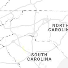
North Carolina
| Local Time | Report Details |
|---|---|
| 3:41 PM EDT | Power lines down in lewisville at the 5900 block of robin hood rd and at the 400 block of sunset ridge d in forsyth county NC, 66.8 miles NNE of Charlotte, NC |
| 4:00 PM EDT | Two trees down at the 1000 block of williams rd in lewisvill in forsyth county NC, 63.9 miles NNE of Charlotte, NC |
| 5:15 PM EDT | Quarter sized hail reported near Huntersville, NC, 13 miles N of Charlotte, NC, trained spotter reported quarter (1.00") size hail on huntersville-concord rd. time estimated from radar. |
| 5:15 PM EDT | Huntersville fire dept/rescue reported numerous trees down across the huntersville area. one tree fell on a home. no injuries were reported. time averaged from rada in mecklenburg county NC, 12.9 miles N of Charlotte, NC |
| 5:30 PM EDT | *** 1 inj *** broadcast media reported several trees down near victoria ave surrounding a mobile home park between skycrest dr and old statesville rd. one person suffer in mecklenburg county NC, 7.4 miles N of Charlotte, NC |
| 6:00 PM EDT | Trees down on power line in vance county NC, 32 miles NNE of Raleigh, NC |
Virginia
| Local Time | Report Details |
|---|---|
| 4:18 PM EDT | Trees down along planters rd near lawrencevill in brunswick county VA, 51.4 miles S of Richmond, VA |
| 4:27 PM EDT | Reports of trees down along dry bread rd. time estimated from rada in brunswick county VA, 58.3 miles S of Richmond, VA |
| 7:23 PM EDT | Tree down at residence on stuart ridge d in fairfax county VA, 45.7 miles WSW of Baltimore, MD |
Wyoming
| Local Time | Report Details |
|---|---|
| 2:27 PM MDT | Golf Ball sized hail reported near Newcastle, WY, 55.1 miles WSW of Rapid City, SD |
Texas
| Local Time | Report Details |
|---|---|
| 4:41 PM CDT | Storm damage reported in carson county TX, 26.5 miles ENE of Amarillo, TX |
| 5:40 PM CDT | Storm damage reported in dickens county TX, 56.9 miles E of Lubbock, TX |
North Dakota
| Local Time | Report Details |
|---|---|
| 5:07 PM CDT | Public noted damage to bean crops due to hail. time estimated on rada in richland county ND, 66.1 miles SSW of Fargo, ND |
Vermont
| Local Time | Report Details |
|---|---|
| 6:19 PM EDT | Multiple trees down reported by law enforcement at lake st. catherin in rutland county VT, 59.1 miles NE of Schenectady, NY |
| 6:32 PM EDT | Trees down in west rutland at the intersection of main street and chapel stree in rutland county VT, 61.7 miles S of Burlington, VT |
| 6:38 PM EDT | Tree down on powerlines causing power outage in windsor county VT, 52.4 miles SSE of Burlington, VT |
| 7:00 PM EDT | Trees and power lines down across the town of plymouth. a few power outages also reporte in windsor county VT, 69.6 miles SSE of Burlington, VT |
| 7:05 PM EDT | Trees down on power line in windsor county VT, 65.4 miles SE of Burlington, VT |
| 7:27 PM EDT | Many trees down with some on power lines. over 1000 people without power due to the trees down on power line in windsor county VT, 79.3 miles SSE of Burlington, VT |
| 7:32 PM EDT | Trees and powerlines down leading to many power outage in orange county VT, 66.6 miles SE of Burlington, VT |
| 7:32 PM EDT | Trees and power lines dow in orange county VT, 67 miles SE of Burlington, VT |
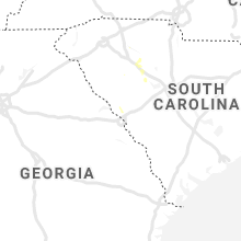
South Carolina
| Local Time | Report Details |
|---|---|
| 6:45 PM EDT | 911 call center reported trees down on anglers haven rd at morse landing rd blocking the roadway. time estimated from rada in laurens county SC, 53.1 miles N of Augusta, GA |
| 6:45 PM EDT | 911 call center reported a tree down blocking one lane at the intersection of barnett rd and morse landing rd. time estimated from rada in laurens county SC, 52.5 miles N of Augusta, GA |
| 8:00 PM EDT | Union 911 call center reported one tree down on goldville rd. time estimated from rada in union county SC, 63 miles ESE of Greenville, SC |
| 8:17 PM EDT | Schp reported tree down in roadway at sc-72 and lake stree in newberry county SC, 59 miles ESE of Greenville, SC |
| 8:24 PM EDT | Schp reports tree in roadway on i-26 at mile marker 62 eastbound. time estimated from rada in newberry county SC, 56.8 miles ESE of Greenville, SC |
| 8:37 PM EDT | Schp reports tree in roadway on i-26 westbound at mile marker 6 in newberry county SC, 61.8 miles ESE of Greenville, SC |
| 8:39 PM EDT | Schp reported tree in roadway on sc-121 and i-26. time estimated from rada in newberry county SC, 62.3 miles NNE of Augusta, GA |
| 8:55 PM EDT | Highway patrol reported a tree down at the intersection of aiport road and hwy. 7 in newberry county SC, 60.6 miles NNE of Augusta, GA |
| 9:04 PM EDT | Estimated wind gusts greater than 60 mph near boyd road and jalapa roa in newberry county SC, 61.6 miles ESE of Greenville, SC |
| 9:10 PM EDT | A peak wind of 68 mph was recorded at the newberry sheriffs offic in newberry county SC, 58.8 miles NNE of Augusta, GA |
New Hampshire
| Local Time | Report Details |
|---|---|
| 7:36 PM EDT | Large limbs on wire in sullivan county NH, 87.1 miles SSE of Burlington, VT |
| 9:30 PM EDT | Large tree down on wires on mt. vernon roa in hillsborough county NH, 81.1 miles N of Providence, RI |
Oklahoma
| Local Time | Report Details |
|---|---|
| 6:53 PM CDT | Quarter sized hail reported near Carter, OK, 70.5 miles NE of Childress, TX, nickel to quarter size hail |
| 7:06 PM CDT | Quarter sized hail reported near Carter, OK, 74.4 miles NE of Childress, TX |
| 7:20 PM CDT | Storm damage reported in jackson county OK, 51.6 miles ENE of Childress, TX |
| 7:30 PM CDT | Storm damage reported in jackson county OK, 51.6 miles ENE of Childress, TX |
| 7:35 PM CDT | Storm damage reported in jackson county OK, 51.6 miles ENE of Childress, TX |
| 7:40 PM CDT | Storm damage reported in jackson county OK, 52.3 miles ENE of Childress, TX |
| 7:50 PM CDT | Storm damage reported in jackson county OK, 51.6 miles ENE of Childress, TX |
| 10:35 PM CDT | Storm damage reported in tillman county OK, 40.9 miles NW of Wichita Falls, TX |
| 11:05 PM CDT | Relayed via kswo-tv in comanche county OK, 51.1 miles NNW of Wichita Falls, TX |
| 11:10 PM CDT | Storm damage reported in grady county OK, 15.8 miles SW of Oklahoma City, OK |
| 11:40 PM CDT | Storm damage reported in cleveland county OK, 11.9 miles S of Oklahoma City, OK |
| 11:41 PM CDT | Pea size hail in cleveland county OK, 18 miles SSE of Oklahoma City, OK |
Minnesota
| Local Time | Report Details |
|---|---|
| 6:57 PM CDT | Quarter sized hail reported near Ortonville, MN, 46 miles NW of Montevideo, MN, wind speed estimated 40-50mph. relayed through nws fgf. |
| 7:15 PM CDT | Golf Ball sized hail reported near Ortonville, MN, 41.4 miles NW of Montevideo, MN, time estimated by radar. |
| 10:27 PM CDT | Corrects time of previous tstm wnd gst report from pipestone. some power outages reported around tow in pipestone county MN, 37.8 miles NNE of Sioux Falls, SD |
| 10:32 PM CDT | Some power outages reported around tow in pipestone county MN, 37.8 miles NNE of Sioux Falls, SD |
| 10:53 PM CDT | Power lines down in wilmont. picture via social medi in nobles county MN, 47.5 miles ENE of Sioux Falls, SD |
| 10:56 PM CDT | Structural damage to a pair of garages in town. one garage blown off its foundation with cinder blocks from foundation rolled northeast. additional damage to trees in t in murray county MN, 54.1 miles NE of Sioux Falls, SD |
| 11:45 PM CDT | Tree branches down blocking the road at 12th street and miller ave on the east side of tow in cottonwood county MN, 80.3 miles SSE of Montevideo, MN |
| 11:50 PM CDT | Rwis statio in murray county MN, 62.6 miles S of Montevideo, MN |
| 11:54 PM CDT | Large tree down that caused gas leak - delayed report... time estimated from rada in watonwan county MN, 82.4 miles SE of Montevideo, MN |
| 12:03 AM CDT | Powerlines down in st james - delayed report... time estimated from rada in watonwan county MN, 86 miles SE of Montevideo, MN |
| 12:14 AM CDT | Powerlines down in medilia... also trees down across the county - delayed report... time estimated from rada in watonwan county MN, 85.9 miles SW of Minneapolis, MN |
| 12:20 AM CDT | 6-8 inch diameter branch dow in faribault county MN, 65 miles NW of Mason City, IA |
| 12:25 AM CDT | 2-3 inch diameter branches dow in brown county MN, 82.1 miles SE of Montevideo, MN |
| 12:33 AM CDT | Tree damage in mapleton and damage to transformer - delayed report... time estimated from rada in blue earth county MN, 66.2 miles NW of Mason City, IA |
| 12:43 AM CDT | A couple trees down in mankato - delayed report... time estimated from rada in blue earth county MN, 67.8 miles SSW of Minneapolis, MN |
| 12:54 AM CDT | Large tree fell on house in janesville - delayed report... time estimated from rada in waseca county MN, 63.3 miles SSW of Minneapolis, MN |
| 1:09 AM CDT | Tree down on powerline with tree on fire - delayed report... time estimated from rada in freeborn county MN, 37 miles NNW of Mason City, IA |
Iowa
| Local Time | Report Details |
|---|---|
| 11:01 PM CDT | Damage to metal shed and many trees down. report via social medi in osceola county IA, 50.8 miles E of Sioux Falls, SD |
| 11:40 PM CDT | 2 large tree branches down blocking lakeshore driv in dickinson county IA, 51.3 miles N of Storm Lake, IA |
| 8:30 AM UTC | Several reports of tree/crop damage near waukon. a camper was rolled over and there was damage to a house... including windows shattered. time estimated from rada in allamakee county IA, 39.2 miles SSW of La Crosse, WI |
Colorado
| Local Time | Report Details |
|---|---|
| 10:33 PM MDT | Quarter sized hail reported near Kit Carson, CO, 84.8 miles S of Yuma, CO, penny to quarter sized hail. |
Connect with Interactive Hail Maps