

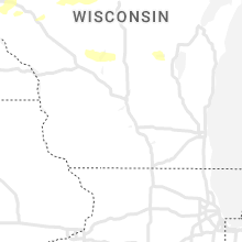
Hail Map for Tuesday, August 2, 2022

Number of Impacted Households on 8/2/2022
0
Impacted by 1" or Larger Hail
0
Impacted by 1.75" or Larger Hail
0
Impacted by 2.5" or Larger Hail
Square Miles of Populated Area Impacted on 8/2/2022
0
Impacted by 1" or Larger Hail
0
Impacted by 1.75" or Larger Hail
0
Impacted by 2.5" or Larger Hail


Cities Most Affected by Hail Storms of 8/2/2022
| Hail Size | Demographics of Zip Codes Affected | ||||||
|---|---|---|---|---|---|---|---|
| City | Count | Average | Largest | Pop Density | House Value | Income | Age |
| Makinen, MN | 2 | 1.75 | 1.75 | 3 | $73k | $39.7k | 51.9 |
Hail and Wind Damage Spotted on 8/2/2022
Filter by Report Type:Hail ReportsWind Reports
States Impacted
Illinois, Oregon, Arkansas, Missouri, Minnesota, North Carolina, Florida, Wyoming, South Dakota, Idaho, Michigan, Wisconsin, IowaIllinois
| Local Time | Report Details |
|---|---|
| 7:25 AM CDT | Large tree limb blown down. relayed via wmbd-t in knox county IL, 23 miles WNW of Peoria, IL |
| 8:05 AM CDT | Large area of corn flattened. time estimated by rada in tazewell county IL, 13.6 miles SSE of Peoria, IL |
| 8:35 AM CDT | Power lines downed from high wind in logan county IL, 35.3 miles SSE of Peoria, IL |
| 8:35 AM CDT | Power lines downed from high wind in logan county IL, 39.3 miles SSE of Peoria, IL |
| 8:35 AM CDT | Power lines downed from high wind in mclean county IL, 34.7 miles SE of Peoria, IL |
| 9:05 AM CDT | Power lines downed from high wind in macon county IL, 39.8 miles NW of Mattoon, IL |
| 9:05 AM CDT | Power lines blown dow in macon county IL, 45.3 miles NW of Mattoon, IL |
| 9:10 AM CDT | Large tree broken on east mound rd. near highway 4 in macon county IL, 40.1 miles NW of Mattoon, IL |
| 9:20 AM CDT | Power lines blown dow in macon county IL, 36.9 miles WNW of Mattoon, IL |
| 9:30 AM CDT | Multiple tree limbs dow in moultrie county IL, 22.3 miles WNW of Mattoon, IL |
| 9:55 AM CDT | Corrects previous tstm wnd dmg report from sullivan. trees uprooted and large branches snapped. power lines downe in moultrie county IL, 14.9 miles WNW of Mattoon, IL |
| 9:55 AM CDT | Quarter sized hail reported near Sullivan, IL, 14.9 miles WNW of Mattoon, IL |
| 11:15 AM CDT | Multiple trees down in the city. light pole down at the baseball fiel in clay county IL, 56.3 miles S of Mattoon, IL |
| 12:02 PM CDT | Quarter sized hail reported near Canton, IL, 25.5 miles WSW of Peoria, IL |
Oregon
| Local Time | Report Details |
|---|---|
| 9:15 AM PDT | 6 inch diameter tree branch and limbs fallen from thunderstorm winds...occurred around 4 a in crook county OR, 2.5 miles ENE of Bend, OR |
Arkansas
| Local Time | Report Details |
|---|---|
| 2:54 PM CDT | Multiple trees were blown down near the intersection of brabec road... arroyo lane... and highway 28. (this is a delayed report in yell county AR, 59.9 miles WNW of Little Rock, AR |
| 4:04 PM CDT | Quarter sized hail reported near Greenbrier, AR, 33.7 miles N of Little Rock, AR, quarter-sized hail reported in the city of greenbrier... ar. (this is a delayed report). |
| 4:04 PM CDT | Quarter sized hail reported near Greenbrier, AR, 32.7 miles NNW of Little Rock, AR, quarter sized hail reported in the city of wooster... ar. (this is a delayed report). |
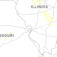
Missouri
| Local Time | Report Details |
|---|---|
| 3:00 PM CDT | Trees down in iberia. power ou in miller county MO, 52.6 miles NW of Salem, MO |
| 3:20 PM CDT | Several large tree limbs down... with the largest being 10-12 inches in diameter. hail was increasing in size... with the largest being just under an inch in diamete in osage county MO, 38.6 miles SE of Columbia, MO |
| 3:20 PM CDT | Images from a trained spotter show several trees and large branches snapped and one tree uprooted along county road 602 south of highway 50. also... the roof of a parti in osage county MO, 39.8 miles SE of Columbia, MO |
| 3:27 PM CDT | Half Dollar sized hail reported near Loose Creek, MO, 37.8 miles SE of Columbia, MO, report from mping: half dollar size hail near loose creek. |
| 3:30 PM CDT | Quarter sized hail reported near Linn, MO, 40.9 miles SE of Columbia, MO, 1 inch diameter hail near linn. |
Minnesota
| Local Time | Report Details |
|---|---|
| 3:00 PM CDT | Golf Ball sized hail reported near Makinen, MN, 41.5 miles NNW of Duluth, MN |
| 3:00 PM CDT | Half Dollar sized hail reported near Makinen, MN, 45.2 miles NNW of Duluth, MN, report via social media with picture. |
| 3:06 PM CDT | Golf Ball sized hail reported near Makinen, MN, 37.9 miles N of Duluth, MN, report from mping: golf ball (1.75 in.). |
| 3:16 PM CDT | Half Dollar sized hail reported near Gilbert, MN, 48.5 miles NNW of Duluth, MN, report via social media with picture. |
| 3:22 PM CDT | Ping Pong Ball sized hail reported near Makinen, MN, 37.5 miles N of Duluth, MN, report via social media. |
| 3:30 PM CDT | Half Dollar sized hail reported near Bigfork, MN, 64.4 miles S of International Falls, MN, report via social media with picture. |
| 3:59 PM CDT | Ping Pong Ball sized hail reported near Makinen, MN, 36.6 miles N of Duluth, MN, report from mping: ping pong ball (1.50 in.). |
| 4:00 PM CDT | Ping Pong Ball sized hail reported near Makinen, MN, 36.6 miles N of Duluth, MN, report from mping: ping pong ball (1.50 in.). |
| 10:05 PM CDT | Storm damage reported in lyon county MN, 30.2 miles SSW of Montevideo, MN |
| 10:08 PM CDT | Awos station kmml marshall municipal airpor in lyon county MN, 35 miles S of Montevideo, MN |
| 10:23 PM CDT | Storm damage reported in redwood county MN, 34.9 miles SSE of Montevideo, MN |
| 10:35 PM CDT | Awos station kgdb granite falls a in yellow medicine county MN, 16.2 miles SSE of Montevideo, MN |
| 10:37 PM CDT | 60 to 62 mph wind gusts for the last 10 mins at the mndot site near luca in redwood county MN, 40 miles SSE of Montevideo, MN |
| 10:51 PM CDT | Krwf airpor in redwood county MN, 41.9 miles SE of Montevideo, MN |
| 10:53 PM CDT | Kovl airpor in renville county MN, 35.8 miles ESE of Montevideo, MN |
| 10:53 PM CDT | Asos station krwf redwood falls a in redwood county MN, 41.9 miles SE of Montevideo, MN |
| 11:02 PM CDT | Mndot wind sensor west of hecto in renville county MN, 48.6 miles ESE of Montevideo, MN |
| 11:10 PM CDT | Hector airpor in renville county MN, 51.8 miles ESE of Montevideo, MN |
| 11:12 PM CDT | Private weather statio in renville county MN, 57.7 miles E of Montevideo, MN |
| 11:19 PM CDT | Khcd - hutchinson airpor in mcleod county MN, 55.3 miles W of Minneapolis, MN |
| 11:20 PM CDT | Photos on social media of medium to large limbs down on roadway. time estimated by rada in mcleod county MN, 54.6 miles W of Minneapolis, MN |
| 11:25 PM CDT | Trained spotter reported several tree branches larger than 6 inches diameter dow in mcleod county MN, 55 miles W of Minneapolis, MN |
| 11:30 PM CDT | 20in or more diameter/large trees down in hutchinson on houses... in yards... and in the street in mcleod county MN, 54.2 miles W of Minneapolis, MN |
| 11:53 PM CDT | Full size trees down reported on social media in norwood young americ in carver county MN, 35 miles WSW of Minneapolis, MN |
| 12:20 AM CDT | Storm damage reported in hennepin county MN, 11.9 miles S of Minneapolis, MN |
| 12:20 AM CDT | Tree branches down on hennepin ave in uptown minneapolis. time estimate in hennepin county MN, 2.6 miles SW of Minneapolis, MN |
| 12:23 AM CDT | Asos station kmsp minneapolis-st. paul a in hennepin county MN, 7 miles SSE of Minneapolis, MN |
| 12:30 AM CDT | Trees down in a mobile home park. time estimate in ramsey county MN, 9.5 miles ENE of Minneapolis, MN |
| 12:31 AM CDT | Some tree damage in the daytons bluff area. time estimate in ramsey county MN, 10.1 miles E of Minneapolis, MN |
| 12:33 AM CDT | Trees and tree branches down. time estimate in ramsey county MN, 11.1 miles ENE of Minneapolis, MN |
| 12:45 AM CDT | Mndot wind sensor near red win in goodhue county MN, 38.2 miles SE of Minneapolis, MN |
North Carolina
| Local Time | Report Details |
|---|---|
| 4:25 PM EDT | Tree down on hous in mcdowell county NC, 61.7 miles WNW of Charlotte, NC |
| 4:25 PM EDT | Trees down on roadwa in mcdowell county NC, 61.2 miles WNW of Charlotte, NC |
| 6:05 PM EDT | Tree down across interstate 85 southbound near exit in cleveland county NC, 30.7 miles W of Charlotte, NC |
| 6:52 PM EDT | Trees down on roadwa in mcdowell county NC, 61.2 miles WNW of Charlotte, NC |
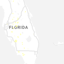
Florida
| Local Time | Report Details |
|---|---|
| 4:55 PM EDT | Courtesy of weatherstem at gulf county salinas par in gulf county FL, 78.7 miles SE of Miramar Beach, FL |
| 6:15 PM EDT | A screened porch/patio extension area had cover damage. estimated winds from nearby reports were around 40 mp in polk county FL, 43.3 miles SSW of Orlando, FL |
Wyoming
| Local Time | Report Details |
|---|---|
| 3:16 PM MDT | Wydot mesonet station gun barrell (kgun) measured wind gust along us highway 8 in laramie county WY, 45.6 miles SW of Scottsbluff, NE |
| 3:30 PM MDT | Upr mesonet station lndbrg (ur343) measured wind gus in laramie county WY, 43.4 miles SSW of Scottsbluff, NE |
South Dakota
| Local Time | Report Details |
|---|---|
| 5:57 PM CDT | Storm damage reported in tripp county SD, 50.3 miles NE of Valentine, NE |
| 6:10 PM CDT | Storm damage reported in tripp county SD, 43.1 miles NE of Valentine, NE |
| 6:32 PM CDT | Mesonet station 54 reliance (sddot in lyman county SD, 53.2 miles SE of Pierre, SD |
| 6:45 PM CDT | Mesonet station ocms2 oacoma 2w (sd mesonet in lyman county SD, 60.7 miles SE of Pierre, SD |
| 6:59 PM CDT | Storm damage reported in todd county SD, 41 miles NW of Valentine, NE |
| 8:00 PM CDT | Reported rain and strong winds. winds ripped ceiling panels off pourc in jerauld county SD, 93 miles WNW of Sioux Falls, SD |
| 8:00 PM CDT | Reported downed power lines and multiple branches... one 2 ft diameter (estimated) tree. time estimated by rada in sanborn county SD, 84.9 miles WNW of Sioux Falls, SD |
| 8:05 PM CDT | 6 inch diameter branch dow in sanborn county SD, 67.6 miles WNW of Sioux Falls, SD |
| 8:20 PM CDT | Storm damage reported in miner county SD, 52 miles NW of Sioux Falls, SD |
| 8:50 PM CDT | Storm damage reported in kingsbury county SD, 59.6 miles NNW of Sioux Falls, SD |
| 9:13 PM CDT | Storm damage reported in hamlin county SD, 69.9 miles WSW of Montevideo, MN |
| 9:15 PM CDT | Mesonet station fw0832 estellin in hamlin county SD, 71.2 miles NNW of Sioux Falls, SD |
| 9:29 PM CDT | Mesonet station 47 brandt (sddot in deuel county SD, 57.8 miles WSW of Montevideo, MN |
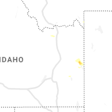
Idaho
| Local Time | Report Details |
|---|---|
| 5:00 PM MDT | Quarter sized hail reported near Swan Valley, ID, 37.7 miles E of Idaho Falls, ID, second report of quarter size hail in irwin... with photos submitted to nws pocatello via social media. time estimated based on radar. |
| 5:06 PM MDT | Quarter sized hail reported near Irwin, ID, 39.5 miles E of Idaho Falls, ID |
Michigan
| Local Time | Report Details |
|---|---|
| 9:11 PM EDT | Michigan dot reports eastbound and westbound lanes of m-28 are closed in kenton due to a downed tree on the highway. relayed report via social medi in houghton county MI, 63.9 miles NNE of Rhinelander, WI |
| 9:55 PM EDT | Tree down and damaged the power mast of the roof on the northside of west bass lake. report relayed from wjmntv3 meteorologis in marquette county MI, 20.8 miles SSW of Marquette, MI |
| 10:00 PM EDT | Report from mping: trees uprooted or snapped. event time based off mqt rada in marquette county MI, 21.7 miles SSW of Marquette, MI |
| 10:00 PM EDT | Report from mping: trees uprooted or snapped. event time based off mqt rada in marquette county MI, 14.8 miles SSW of Marquette, MI |
| 10:05 PM EDT | Law enforcement reports downed power lines on shag lake drive in forsyth township. time is estimated from mqt rada in marquette county MI, 19.5 miles SSW of Marquette, MI |
| 10:06 PM EDT | Law enforcement dispatch reports a power line down across m-35 between chipmunk field and the cataract basin drive west of princeton. time based on rada in marquette county MI, 17.6 miles SSW of Marquette, MI |
| 10:06 PM EDT | Marquette county law enforcement dispatch reports large trees and downed wires suspended on other wires around the princeton area west of gwinn along m-35 in forsyth to in marquette county MI, 17.9 miles SSW of Marquette, MI |
| 10:10 PM EDT | Multiple power outages are reported in forsyth and richmond townships in marquette county. event time based on rada in marquette county MI, 17.9 miles S of Marquette, MI |
| 5:54 AM CDT | Asos station kimt kingsfor in dickinson county MI, 60.5 miles SW of Marquette, MI |
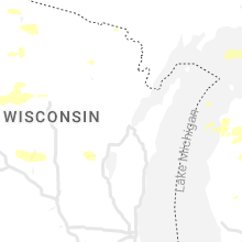
Wisconsin
| Local Time | Report Details |
|---|---|
| 8:30 PM CDT | Quarter sized hail reported near Danbury, WI, 55.3 miles SSW of Duluth, MN, time estimated by radar. |
| 8:52 PM CDT | Ping Pong Ball sized hail reported near Webster, WI, 58.7 miles S of Duluth, MN |
| 9:10 PM CDT | 20 inch diameter white pine limb down. several other limbs down in the area. power outages as well. time estimated by rada in washburn county WI, 67.5 miles SSE of Duluth, MN |
| 9:10 PM CDT | Corrects previous flash flood report from stone lake. large oak trees uprooted. report relayed by social media. time estimated by rada in sawyer county WI, 70.1 miles SSE of Duluth, MN |
| 9:42 PM CDT | Quarter sized hail reported near Spooner, WI, 67.6 miles S of Duluth, MN, report from mping: quarter (1.00 in.). |
| 11:11 PM CDT | 1 tree down in tomahawk in lincoln county WI, 19.8 miles SW of Rhinelander, WI |
| 1:35 AM CDT | Awos station klum menomonie a in dunn county WI, 68.6 miles E of Minneapolis, MN |
| 2:05 AM CDT | Trees down. time estimate in chippewa county WI, 82.3 miles N of La Crosse, WI |
| 3:35 AM CDT | Trees down in merril in lincoln county WI, 34.2 miles SSW of Rhinelander, WI |
Iowa
| Local Time | Report Details |
|---|---|
| 6:19 AM CDT | Kslb awos statio in buena vista county IA, 3.8 miles SSW of Storm Lake, IA |
Connect with Interactive Hail Maps