

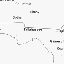
Hail Map for Friday, August 22, 2014

Number of Impacted Households on 8/22/2014
0
Impacted by 1" or Larger Hail
0
Impacted by 1.75" or Larger Hail
0
Impacted by 2.5" or Larger Hail
Square Miles of Populated Area Impacted on 8/22/2014
0
Impacted by 1" or Larger Hail
0
Impacted by 1.75" or Larger Hail
0
Impacted by 2.5" or Larger Hail


Cities Most Affected by Hail Storms of 8/22/2014
| Hail Size | Demographics of Zip Codes Affected | ||||||
|---|---|---|---|---|---|---|---|
| City | Count | Average | Largest | Pop Density | House Value | Income | Age |
| Phillipsburg, KS | 1 | 1.75 | 1.75 | 8 | $59k | $37.7k | 44.7 |
| Richfield, ID | 1 | 1.75 | 1.75 | 9 | $59k | $33.4k | 33.8 |
| Sheridan Lake, CO | 1 | 1.75 | 1.75 | 1 | $25k | $30.7k | 38.8 |
| Weston, WY | 1 | 1.75 | 1.75 | 0 | $30k | $53.9k | 47.9 |
Hail and Wind Damage Spotted on 8/22/2014
Filter by Report Type:Hail ReportsWind Reports
States Impacted
North Carolina, Kansas, Colorado, Texas, Idaho, Florida, Wyoming, New Mexico, Missouri, Nebraska, Montana, Oklahoma, UtahNorth Carolina
| Local Time | Report Details |
|---|---|
| 11:15 AM EDT | Half of a large tree fell on a porch to a house...damaging the roof and gutters. report from social medi in mecklenburg county NC, 7.2 miles NE of Charlotte, NC |
| 5:32 PM EDT | One tree down on the 1400 block of matthews mill pond road in angier. time estimated by rada in harnett county NC, 22.1 miles SSW of Raleigh, NC |
| 11:15 PM EDT | A tree fell on a house and shed near the intersection of piney church road and zion church road. the shed is smashed but only minimal damage to the house. time is from in cabarrus county NC, 17.5 miles ENE of Charlotte, NC |
| 11:15 PM EDT | Half of a large tree fell on a porch to a house...damaging the roof and gutters. report from social medi in mecklenburg county NC, 7.2 miles NE of Charlotte, NC |
| 11:15 PM EDT | Half of a large tree fell on a porch to a house...damaging the roof and gutters. report from social medi in rowan county NC, 26 miles NNE of Charlotte, NC |
| 11:28 PM EDT | One tree reported to have fallen during the storm. likely fell on east side of city where the higher radar velocities were observe in cabarrus county NC, 22.2 miles NNE of Charlotte, NC |
Kansas
| Local Time | Report Details |
|---|---|
| 11:30 AM CDT | Very brief strong gusty winds estimated upwards of 50 mph. 1 1/2 to 2 inch diameter tree limbs down from a 3-year old maple tre in osage county KS, 61.6 miles SE of Manhattan, KS |
| 1:32 PM CDT | Storm damage reported in coffey county KS, 45.2 miles NNW of Chanute, KS |
| 4:26 PM CDT | Storm damage reported in finney county KS, 10.4 miles WNW of Garden City, KS |
| 4:48 PM CDT | Quarter sized hail reported near Holcomb, KS, 6.5 miles WNW of Garden City, KS, mostly nickels/dimes but a few quarters mixed in |
| 4:50 PM CDT | The gust was measured from a davis weather instrument in scott county KS, 20.8 miles N of Garden City, KS |
| 4:55 PM CDT | Storm damage reported in finney county KS, 19.5 miles N of Garden City, KS |
| 5:09 PM CDT | Storm damage reported in hodgeman county KS, 56.4 miles E of Garden City, KS |
| 4:11 PM MDT | Picnic table and two motorcycles overturne in greeley county KS, 55.9 miles NW of Garden City, KS |
| 4:15 PM MDT | Quarter sized hail reported near Tribune, KS, 68.4 miles WNW of Garden City, KS, mostly dime size with a few quarter size hailstones. |
| 5:20 PM CDT | Storm damage reported in scott county KS, 35.3 miles N of Garden City, KS |
| 5:25 PM CDT | Tractor trailer blown over on k-6 in reno county KS, 50.7 miles WNW of Wichita, KS |
| 5:40 PM CDT | Storm damage reported in hodgeman county KS, 52.8 miles SSW of Hays, KS |
| 4:41 PM MDT | Storm damage reported in sherman county KS, 40.9 miles W of Colby, KS |
| 5:48 PM CDT | Golf Ball sized hail reported near Phillipsburg, KS, 73.2 miles N of Hays, KS |
| 5:48 PM CDT | Visibility down to 1/8th mile from dust. power briefly went out just before winds hit. small limbs down in yar in miami county KS, 40.7 miles S of Kansas City, MO |
| 4:53 PM MDT | Storm damage reported in wallace county KS, 51.9 miles SW of Colby, KS |
| 5:55 PM CDT | Quarter sized hail reported near Saint Francis, KS, 47.7 miles NW of Colby, KS, nickel to quarter size hail. |
| 5:57 PM CDT | Emergency manager reports multiple power lines down on u.s. highway 50. time is based on report of wind gust in proximit in reno county KS, 36.3 miles NW of Wichita, KS |
| 5:00 PM MDT | Half Dollar sized hail reported near Goodland, KS, 40.5 miles W of Colby, KS |
| 6:03 PM CDT | Power lines down near 311th street and hwy 6 in miami county KS, 38 miles S of Kansas City, MO |
| 6:05 PM CDT | Also blowing dust with near zero visibility in logan county KS, 30.6 miles SSE of Colby, KS |
| 6:10 PM CDT | Delayed report. multiple telephone poles snapped at base along metcalf road between 303rd and 327th streets. as of 830 pm cdt this evening...metcalf road remains closed in miami county KS, 37.1 miles S of Kansas City, MO |
| 6:12 PM CDT | Numerous trees and powerlines reported down. power reported out in the area of 327th and beaver creek r in miami county KS, 40.5 miles SSW of Kansas City, MO |
| 6:14 PM CDT | Numerous reports of trees and powerlines down in this are in miami county KS, 36.5 miles S of Kansas City, MO |
| 6:16 PM CDT | Power is out and 5-6 inch diameter tree limbs dow in miami county KS, 36.3 miles S of Kansas City, MO |
| 5:17 PM MDT | Quarter sized hail reported near Goodland, KS, 36.6 miles WNW of Colby, KS |
| 6:21 PM CDT | Storm damage reported in gove county KS, 23.3 miles SE of Colby, KS |
| 6:30 PM CDT | Storm damage reported in pawnee county KS, 48 miles SSE of Hays, KS |
| 6:30 PM CDT | Winds blew out windows of residenc in cheyenne county KS, 36.5 miles WNW of Colby, KS |
| 6:32 PM CDT | 60 to 70 mph winds estimate in gove county KS, 29.3 miles SE of Colby, KS |
| 6:35 PM CDT | The top of a small barn blew off from estimated greater than 60 mph thunderstorm gus in trego county KS, 19.8 miles NW of Hays, KS |
| 6:40 PM CDT | Powerpoles were reported down on grants villa road in ellis county KS, 14.5 miles WSW of Hays, KS |
| 6:40 PM CDT | Powerlines were reported down in the vicinity of butterfield trail road and ellis avenue in ellis county KS, 13.8 miles WSW of Hays, KS |
| 6:44 PM CDT | Storm damage reported in ellis county KS, 12.3 miles W of Hays, KS |
| 6:45 PM CDT | Storm damage reported in ellis county KS, 13.5 miles W of Hays, KS |
| 6:45 PM CDT | A small shop had some roof damage and part of a brick wall blown in. large trees were also blown down in tow in ellis county KS, 13.2 miles WNW of Hays, KS |
| 5:55 PM MDT | Semi blown over just west of brewster on interstate 70. time estimated via rada in sherman county KS, 19.4 miles WSW of Colby, KS |
| 9:10 PM CDT | Storm damage reported in smith county KS, 59.6 miles NNE of Hays, KS |
Colorado
| Local Time | Report Details |
|---|---|
| 1:45 PM MDT | Half Dollar sized hail reported near Kit Carson, CO, 93.8 miles S of Yuma, CO, also received 1.30 inches of rain in 30 minutes |
| 2:54 PM MDT | Storm damage reported in otero county CO, 33.5 miles ESE of Pueblo, CO |
| 3:11 PM MDT | Quarter sized hail reported near Burlington, CO, 61.2 miles SSE of Yuma, CO, received via mping. |
| 3:42 PM MDT | Quarter sized hail reported near Arapahoe, CO, 75.5 miles WSW of Colby, KS, quarter size hail covering the ground. |
| 4:24 PM MDT | Storm damage reported in otero county CO, 33.5 miles ESE of Pueblo, CO |
| 4:28 PM MDT | Golf Ball sized hail reported near Sheridan Lake, CO, 74.7 miles WNW of Garden City, KS |
| 6:20 PM MDT | 60 to 70 mph winds estimate in cheyenne county CO, 85.4 miles S of Yuma, CO |
Texas
| Local Time | Report Details |
|---|---|
| 3:30 PM CDT | Report of an irrigation center pivot being overturned by thunderstorm wind gust in hartley county TX, 48.1 miles NW of Amarillo, TX |
| 6:39 PM CDT | Storm damage reported in winkler county TX, 46 miles W of Odessa, TX |
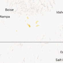
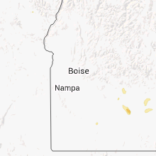
Idaho
| Local Time | Report Details |
|---|---|
| 3:16 PM MDT | Quarter sized hail reported near Richfield, ID, 37.8 miles NNE of Twin Falls, ID, quarter size hail reported |
| 3:16 PM MDT | Golf Ball sized hail reported near Richfield, ID, 37.8 miles NNE of Twin Falls, ID, golf ball size hail reported |
| 3:45 PM MDT | Quarter sized hail reported near Richfield, ID, 37.8 miles NNE of Twin Falls, ID, one inch hail |
| 7:15 PM MDT | Quarter sized hail reported near Gooding, ID, 28.8 miles NNW of Twin Falls, ID, spotter reported 1 inch hail... water running through his shop... and downed branches in his yard measuring 2.5 inches. |
| 7:30 PM MDT | Quarter sized hail reported near Gooding, ID, 28.8 miles NNW of Twin Falls, ID, spotter reported a lot of 1 inch hail... a torn up front porch... and the neighbors roof pulled back. |
| 7:41 PM MDT | Ping Pong Ball sized hail reported near Jerome, ID, 12.8 miles NNW of Twin Falls, ID, spotter reported ping pong ball sized hail. he said the ground is almost white and that his corn suffered some damage. |
| 8:10 PM MDT | Quarter sized hail reported near Twin Falls, ID, 0.6 miles ENE of Twin Falls, ID, large amounts of large hail in twin falls. this combined with heavy rain to produce minor street flooding as well. |
Florida
| Local Time | Report Details |
|---|---|
| 5:50 PM EDT | Sheriffs office reported trees down on county road 225 north of gainesvill in alachua county FL, 55.3 miles SW of Jacksonville, FL |
| 6:25 PM EDT | Quarter sized hail reported near Gainesville, FL, 67.2 miles SW of Jacksonville, FL, hail reported on archer road just west of interstate 75. |
Wyoming
| Local Time | Report Details |
|---|---|
| 4:45 PM MDT | Storm damage reported in campbell county WY, 24.9 miles NNW of Gillette, WY |
| 5:45 PM MDT | Golf Ball sized hail reported near Weston, WY, 26 miles NNE of Gillette, WY, last at least 15 minutes. looks like it snowed due to the volume of the hail. |
| 6:15 PM MDT | Half Dollar sized hail reported near Weston, WY, 28.6 miles NE of Gillette, WY, wind gusts 65 mph reported |
| 6:50 PM MDT | Storm damage reported in crook county WY, 35.5 miles NE of Gillette, WY |
| 7:20 PM MDT | Pea size hail on the ground 4 inches deep in crook county WY, 42.6 miles NE of Gillette, WY |
| 7:20 PM MDT | Pea size hail on the ground 4 inches deep in crook county WY, 42.6 miles NE of Gillette, WY |
New Mexico
| Local Time | Report Details |
|---|---|
| 5:22 PM MDT | Kcvn awo in curry county NM, 63.6 miles SE of Tucumcari, NM |
Missouri
| Local Time | Report Details |
|---|---|
| 6:40 PM CDT | Tree down on hwy c south of peculiar. location estimate in cass county MO, 28.6 miles SSE of Kansas City, MO |
| 6:40 PM CDT | Storm damage reported in cass county MO, 27.9 miles SSE of Kansas City, MO |
| 6:45 PM CDT | Tin roof blown off outbuilding just off interstate 49. location estimated based off of rada in cass county MO, 28.2 miles SSE of Kansas City, MO |
Nebraska
| Local Time | Report Details |
|---|---|
| 6:10 PM MDT | Quarter sized hail reported near Benkelman, NE, 47 miles NNW of Colby, KS |
| 6:10 PM MDT | Storm damage reported in dundy county NE, 47.2 miles NNW of Colby, KS |
| 9:59 PM CDT | Storm damage reported in buffalo county NE, 39.4 miles W of Grand Island, NE |
Montana
| Local Time | Report Details |
|---|---|
| 6:43 PM MDT | Half Dollar sized hail reported near Broadus, MT, 65.4 miles S of Miles City, MT |
| 6:45 PM MDT | Half Dollar sized hail reported near Broadus, MT, 64 miles S of Miles City, MT |
| 6:45 PM MDT | Metal roof blown off shed and carried by the wind through corrals. damage to corrals. door blown off another she in powder river county MT, 64 miles S of Miles City, MT |
| 6:47 PM MDT | Quarter sized hail reported near Broadus, MT, 65.3 miles SSE of Miles City, MT |
Oklahoma
| Local Time | Report Details |
|---|---|
| 8:25 PM CDT | Storm damage reported in beaver county OK, 49.3 miles WNW of Woodward, OK |
Utah
| Local Time | Report Details |
|---|---|
| 3:55 AM MDT | Simpson springs sensor dpg21 in tooele county UT, 80.2 miles SW of Salt Lake City, UT |
Connect with Interactive Hail Maps