

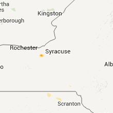
Hail Map for Sunday, August 7, 2011

Number of Impacted Households on 8/7/2011
0
Impacted by 1" or Larger Hail
0
Impacted by 1.75" or Larger Hail
0
Impacted by 2.5" or Larger Hail
Square Miles of Populated Area Impacted on 8/7/2011
0
Impacted by 1" or Larger Hail
0
Impacted by 1.75" or Larger Hail
0
Impacted by 2.5" or Larger Hail


Cities Most Affected by Hail Storms of 8/7/2011
| Hail Size | Demographics of Zip Codes Affected | ||||||
|---|---|---|---|---|---|---|---|
| City | Count | Average | Largest | Pop Density | House Value | Income | Age |
| Kilgore, NE | 3 | 2.42 | 2.75 | 0 | $30k | $28.9k | 44.8 |
| Rapid City, SD | 3 | 2.08 | 2.75 | 111 | $119k | $47.4k | 44.3 |
| Belle Fourche, SD | 2 | 2.25 | 2.50 | 6 | $67k | $30.1k | 39.3 |
| Spartanburg, SC | 1 | 1.75 | 1.75 | 409 | $106k | $38.0k | 44.5 |
| Hermosa, SD | 1 | 1.75 | 1.75 | 3 | $127k | $35.4k | 44.4 |
| Saint Francis, SD | 1 | 1.75 | 1.75 | 0 | $10k | $19.4k | 22.8 |
| Pine Ridge, SD | 1 | 1.75 | 1.75 | 0 | $21k | $20.8k | 23.5 |
| Medaryville, IN | 1 | 1.75 | 1.75 | 22 | $73k | $32.3k | 40.9 |
| Bald Knob, AR | 1 | 1.75 | 1.75 | 40 | $47k | $29.2k | 38.6 |
| Nemo, SD | 1 | 1.75 | 1.75 | 4 | $122k | $37.7k | 33.3 |
| Wanblee, SD | 1 | 1.75 | 1.75 | 1 | $62k | $13.8k | 22.5 |
Hail and Wind Damage Spotted on 8/7/2011
Filter by Report Type:Hail ReportsWind Reports
States Impacted
Kansas, Indiana, South Dakota, Arkansas, New York, Texas, Ohio, Missouri, Florida, Nebraska, Virginia, Michigan, Illinois, Georgia, Arizona, Mississippi, Wyoming, Alabama, South Carolina, West Virginia, Tennessee, Kentucky, North Carolina, Iowa, OklahomaKansas
| Local Time | Report Details |
|---|---|
| 2:55 PM UTC | Quarter sized hail reported near Burr Oak, KS, 72.8 miles S of Grand Island, NE |
| 3:58 PM UTC | Quarter sized hail reported near Hanover, KS, 52.7 miles NNW of Manhattan, KS, nickel to quarter size. |
| 4:09 PM UTC | Quarter sized hail reported near Hanover, KS, 51.9 miles NNW of Manhattan, KS |
| 4:24 PM UTC | Quarter sized hail reported near Hanover, KS, 51.3 miles NNW of Manhattan, KS, hail fell to the ground for 10 mins. |
| 5:50 PM UTC | 20 foot tall tree was leaning over 2/3 of the way to the groun in pottawatomie county KS, 16.7 miles NNE of Manhattan, KS |
| 6:02 PM UTC | Top half of a 2 foot diameter tree blown over. largest branch was 1 foot in diameter. sheet metal blown around along with lawn furnitur in pottawatomie county KS, 23.8 miles NNE of Manhattan, KS |
| 6:05 PM UTC | A 5 foot diameter tree feel onto house. other tree limbs and debris also reported around tow in pottawatomie county KS, 13.6 miles E of Manhattan, KS |
| 6:10 PM UTC | Trees down around onaga in pottawatomie county KS, 30 miles NE of Manhattan, KS |
| 6:35 PM UTC | Storm damage reported in wabaunsee county KS, 29.5 miles ESE of Manhattan, KS |
| 6:53 PM UTC | Reported tree blown down in shawnee county KS, 47.8 miles ESE of Manhattan, KS |
| 7:05 PM UTC | Extensive tree damage through the city in west to east line. several large trees blown down as well with several large trees also blown onto houses. time estimated base in leavenworth county KS, 23 miles NW of Kansas City, MO |
| 2:05 PM CDT | Quarter sized hail reported near Leavenworth, KS, 24.8 miles NW of Kansas City, MO, reported by the public in fort leavenworth |
| 7:10 PM UTC | Several large trees down on east side of the cit in leavenworth county KS, 23.5 miles NW of Kansas City, MO |
| 7:41 PM UTC | Storm damage reported in douglas county KS, 43.3 miles WSW of Kansas City, MO |
| 7:51 PM UTC | Tree reported blown down onto power lin in franklin county KS, 49.8 miles SW of Kansas City, MO |
| 8:27 PM UTC | Report of tree blown down on 77th and urish road in shawnee county KS, 45.4 miles ESE of Manhattan, KS |
| 10:01 PM UTC | 6 inch tree limb downed and stop sign blown over in woodson county KS, 20.1 miles WNW of Chanute, KS |
| 10:09 PM UTC | An 8 inch diameter tree limb was blown dow in grant county KS, 42 miles SSW of Garden City, KS |
| 10:35 PM UTC | Storm damage reported in neosho county KS, 1 miles SSW of Chanute, KS |
| 11:47 PM UTC | Storm damage reported in meade county KS, 47.8 miles SE of Garden City, KS |
| 11:59 PM UTC | Powerlines were blown dow in hodgeman county KS, 53.7 miles E of Garden City, KS |
| 12:00 AM UTC | Tree was blown dow in ford county KS, 48.7 miles ESE of Garden City, KS |
| 12:03 AM UTC | Storm damage reported in meade county KS, 51.2 miles SE of Garden City, KS |
| 12:05 AM UTC | Winds were estimated at 70 to 80 mph. numerous tree limbs down and some roof damag in hodgeman county KS, 54.2 miles E of Garden City, KS |
| 12:15 AM UTC | A 16 inch diameter tree was blown down on 14th ave 2 blocks north of wyatt ear in ford county KS, 49.3 miles ESE of Garden City, KS |
| 12:22 AM UTC | Powerlines were blown dow in hodgeman county KS, 57.6 miles SSW of Hays, KS |
| 12:50 AM UTC | Four inch tree limbs were blown dow in ford county KS, 65.5 miles ESE of Garden City, KS |
| 12:59 AM UTC | Tree limbs were blown dow in pawnee county KS, 46.4 miles S of Hays, KS |
| 1:00 AM UTC | A large mature elm tree as blown dow in edwards county KS, 65.7 miles S of Hays, KS |
| 1:00 AM UTC | A barn was flattene in edwards county KS, 58.8 miles S of Hays, KS |
| 1:02 AM UTC | Half Dollar sized hail reported near Gove, KS, 55.9 miles NNE of Garden City, KS |
| 1:10 AM UTC | Penny sized hail and an estimated wind gust of 70 mph was reported by the sheriffs station in edwards count in edwards county KS, 65.6 miles S of Hays, KS |
| 1:12 AM UTC | Quarter sized hail reported near Healy, KS, 46.5 miles NNE of Garden City, KS, nickle to quarter size hail was reported. |
| 1:16 AM UTC | Ping Pong Ball sized hail reported near Healy, KS, 45.6 miles NNE of Garden City, KS |
| 1:35 AM UTC | Small hail also occurred at this tim in pawnee county KS, 57.6 miles SSE of Hays, KS |
| 2:00 AM UTC | A wind gust of 60 mph occurred in the town of saint joh in stafford county KS, 67.6 miles SSE of Hays, KS |
| 2:14 AM UTC | Rural power lines were blown down north of staffor in stafford county KS, 70.9 miles SE of Hays, KS |
| 2:25 AM UTC | Tree downed on power line along with 8-10 inch tree limb in reno county KS, 61.7 miles WNW of Wichita, KS |
| 2:35 AM UTC | Estimated 60 to 70 mph wind gusts in reno county KS, 53.4 miles WNW of Wichita, KS |
| 3:01 AM UTC | Storm damage reported in reno county KS, 34.9 miles W of Wichita, KS |
| 3:06 AM UTC | Storm damage reported in kingman county KS, 40.8 miles W of Wichita, KS |
| 3:18 AM UTC | Storm damage reported in reno county KS, 41 miles NW of Wichita, KS |
| 3:20 AM UTC | Quarter sized hail reported near Milford, KS, 19 miles W of Manhattan, KS, fell for 3 to 5 minutes |
| 3:31 AM UTC | Small all terrain vehicle tossed across the yard. estimated 60 to 70 mph wind in clay county KS, 41.3 miles W of Manhattan, KS |
| 3:50 AM UTC | Relayed by media. weather stationa at junction city middle schoo in geary county KS, 17.7 miles SW of Manhattan, KS |
| 4:00 AM UTC | Quarter sized hail reported near Osborne, KS, 39.2 miles NE of Hays, KS, quarter size hail lasting about 10 to 15 minutes. this is a delayed report. |
| 4:05 AM UTC | Power lines down in junction city in geary county KS, 17.7 miles SW of Manhattan, KS |
| 4:15 AM UTC | Delayed report. trees down 3se of eskridg in wabaunsee county KS, 35.8 miles SE of Manhattan, KS |
| 4:15 AM UTC | Large oak tree blown dow in dickinson county KS, 33.8 miles W of Manhattan, KS |
| 4:45 AM UTC | Delayed report. tree down 2s of alta vist in wabaunsee county KS, 24.4 miles S of Manhattan, KS |
| 5:02 AM UTC | Large tree down across k-99 near lake wabaunsee in wabaunsee county KS, 30.1 miles SE of Manhattan, KS |
| 5:14 AM UTC | Quarter sized hail reported near Burlingame, KS, 49.3 miles SE of Manhattan, KS, lots of nickel to quarter size hail. |
| 5:30 AM UTC | Delayed report. large tree limbs down near barcla in osage county KS, 54.6 miles SE of Manhattan, KS |
| 5:45 AM UTC | Storm damage reported in coffey county KS, 49.7 miles NNW of Chanute, KS |
| 5:52 AM UTC | Storm damage reported in coffey county KS, 45.2 miles NNW of Chanute, KS |
Indiana
| Local Time | Report Details |
|---|---|
| 3:58 PM UTC | Golf Ball sized hail reported near Medaryville, IN, 62.5 miles SE of Chicago, IL, golf ball size hail reported near the starke and pulaski county line with tree branches down |
| 4:42 PM UTC | Tree limbs down with power outages...time estimated from radar in white county IN, 83.1 miles NW of Indianapolis, IN |
| 5:22 PM UTC | Trees and limbs down...areas of corn down in white county IN, 70.6 miles NW of Indianapolis, IN |
| 5:34 PM UTC | Trees down...time estimated from radar in miami county IN, 46.6 miles WSW of Fort Wayne, IN |
| 6:05 PM UTC | Storm damage reported in grant county IN, 54 miles NNE of Indianapolis, IN |
| 6:05 PM UTC | Large tree and power lines down. wind estimated at 60 mp in howard county IN, 49.2 miles N of Indianapolis, IN |
| 6:34 PM UTC | Measured at the asos at west lafayette airport...kla in tippecanoe county IN, 61.5 miles NW of Indianapolis, IN |
| 6:35 PM UTC | Storm damage reported in blackford county IN, 45.4 miles SSW of Fort Wayne, IN |
| 6:45 PM UTC | Storm damage reported in wells county IN, 14.7 miles SSW of Fort Wayne, IN |
| 6:45 PM UTC | Storm damage reported in wells county IN, 16 miles SSW of Fort Wayne, IN |
| 8:05 PM UTC | Healthy tree branches were blown down on pinecreek way with a diameter of about 5 inche in marion county IN, 13.8 miles NE of Indianapolis, IN |
| 8:05 PM UTC | Power was out...doors blown open...and stock blown off shelves at meijer on 96th street located just east of interstate 69 in marion county IN, 14.6 miles NE of Indianapolis, IN |
| 8:05 PM UTC | Trees were blow down at the following locations in the geist reservoir area...10500 block of fall creek road...900 block of brigs way...and 10300 block of stormhaven wa in marion county IN, 14.6 miles NE of Indianapolis, IN |
| 1:12 AM UTC | Storm damage reported in elkhart county IN, 51.8 miles NW of Fort Wayne, IN |
| 1:12 AM UTC | Storm damage reported in elkhart county IN, 51.8 miles NW of Fort Wayne, IN |
| 1:30 AM UTC | Several large limbs down in kosciusko county IN, 34.3 miles WNW of Fort Wayne, IN |
South Dakota
| Local Time | Report Details |
|---|---|
| 6:45 PM UTC | Golf Ball sized hail reported near Nemo, SD, 15.3 miles WNW of Rapid City, SD |
| 7:15 PM UTC | Quarter sized hail reported near Rapid City, SD, 7.9 miles WNW of Rapid City, SD, hailed from 115 pm to 135 pm. hail covered the ground. |
| 8:00 PM UTC | Ping Pong Ball sized hail reported near Rapid City, SD, 3.9 miles W of Rapid City, SD |
| 8:02 PM UTC | Quarter sized hail reported near Rapid City, SD, 4.6 miles SW of Rapid City, SD |
| 8:13 PM UTC | Golf Ball sized hail reported near Rapid City, SD, 3.7 miles SW of Rapid City, SD |
| 8:15 PM UTC | Ping Pong Ball sized hail reported near Rapid City, SD, 4.2 miles S of Rapid City, SD |
| 8:15 PM UTC | Golf Ball sized hail reported near Rapid City, SD, 4.6 miles SW of Rapid City, SD |
| 8:22 PM UTC | Quarter sized hail reported near Rapid City, SD, 3 miles SSE of Rapid City, SD |
| 8:22 PM UTC | Quarter sized hail reported near , , 7.5 miles SW of Rapid City, SD |
| 8:23 PM UTC | Quarter sized hail reported near Rapid City, SD, 6.6 miles SW of Rapid City, SD |
| 8:23 PM UTC | Half Dollar sized hail reported near Hermosa, SD, 16.4 miles SSW of Rapid City, SD |
| 8:23 PM UTC | Half Dollar sized hail reported near Rapid City, SD, 6.6 miles SW of Rapid City, SD |
| 8:23 PM UTC | Golf Ball sized hail reported near , , 7.5 miles SW of Rapid City, SD, severe hail from 223 pm to 235 pm. |
| 8:30 PM UTC | Golf Ball sized hail reported near , , 7.5 miles SW of Rapid City, SD |
| 8:30 PM UTC | Baseball sized hail reported near Rapid City, SD, 8.7 miles SSW of Rapid City, SD |
| 9:10 PM UTC | Ping Pong Ball sized hail reported near Hermosa, SD, 14.8 miles S of Rapid City, SD |
| 9:30 PM UTC | Ping Pong Ball sized hail reported near Hermosa, SD, 18.7 miles S of Rapid City, SD |
| 9:30 PM UTC | Golf Ball sized hail reported near Hermosa, SD, 16.8 miles S of Rapid City, SD |
| 10:00 PM UTC | Quarter sized hail reported near Midland, SD, 50 miles W of Pierre, SD |
| 10:15 PM UTC | Half Dollar sized hail reported near Belle Fourche, SD, 50.9 miles NW of Rapid City, SD |
| 10:20 PM UTC | Quarter sized hail reported near Hermosa, SD, 32.5 miles SE of Rapid City, SD |
| 10:20 PM UTC | Hen Egg sized hail reported near Belle Fourche, SD, 49.2 miles NNW of Rapid City, SD |
| 10:22 PM UTC | Tennis Ball sized hail reported near Belle Fourche, SD, 50.9 miles NW of Rapid City, SD |
| 10:30 PM UTC | Half Dollar sized hail reported near Belle Fourche, SD, 50.9 miles NW of Rapid City, SD, pea to half dollar size hail. |
| 10:30 PM UTC | Golf Ball sized hail reported near Pine Ridge, SD, 37.3 miles SSE of Rapid City, SD |
| 10:35 PM UTC | Quarter sized hail reported near Midland, SD, 38.8 miles WSW of Pierre, SD, nickel and quarter size hail |
| 10:40 PM UTC | Quarter sized hail reported near Midland, SD, 49.8 miles W of Pierre, SD |
| 11:15 PM UTC | 3/4 inch hail to in shannon county SD, 63.8 miles SE of Rapid City, SD |
| 11:15 PM UTC | Small branches broken by wind gust. pea size hai in shannon county SD, 71.4 miles SE of Rapid City, SD |
| 11:15 PM UTC | Golf Ball sized hail reported near Wanblee, SD, 78.1 miles NW of Valentine, NE, 1.30 inches of rain. drifts of hail. corn and garden plants stripped. |
| 11:30 PM UTC | Storm damage reported in shannon county SD, 73.7 miles SE of Rapid City, SD |
| 11:30 PM UTC | Storm damage reported in shannon county SD, 85 miles W of Valentine, NE |
| 11:40 PM UTC | Pea sized hail as well in bennett county SD, 75.5 miles WNW of Valentine, NE |
| 11:45 PM UTC | Storm damage reported in harding county SD, 89.9 miles N of Rapid City, SD |
| 11:45 PM UTC | Storm damage reported in harding county SD, 82.6 miles N of Rapid City, SD |
| 12:00 AM UTC | Storm damage reported in todd county SD, 25.8 miles WNW of Valentine, NE |
| 12:00 AM UTC | Quarter sized hail reported near Belle Fourche, SD, 61.3 miles NNW of Rapid City, SD |
| 12:00 AM UTC | Golf Ball sized hail reported near St Francis, SD, 25.8 miles WNW of Valentine, NE |
| 12:05 AM UTC | Pea to marble size hail in bennett county SD, 47.9 miles WNW of Valentine, NE |
| 12:05 AM UTC | Pea to marble size hail in bennett county SD, 48 miles WNW of Valentine, NE |
| 12:15 AM UTC | Storm damage reported in butte county SD, 51.9 miles NNW of Rapid City, SD |
| 1:05 AM UTC | Storm damage reported in perkins county SD, 92.6 miles NNE of Rapid City, SD |
| 1:05 AM UTC | 6-10 inch diameter tree branches broken off in perkins county SD, 92.6 miles NNE of Rapid City, SD |
| 1:25 AM UTC | Also reported nickle size hail with the storm in dewey county SD, 67.9 miles NW of Pierre, SD |
| 1:30 AM UTC | Storm damage reported in perkins county SD, 99.9 miles NNE of Rapid City, SD |
| 2:25 AM UTC | Also reported nickle size hail with the storm in dewey county SD, 67.9 miles NW of Pierre, SD |
| 3:01 AM UTC | At least 60 mph. rocking farm equipment parked in yard in charles mix county SD, 38 miles NNE of Oneill, NE |
| 4:34 AM UTC | Storm damage reported in union county SD, 66.6 miles W of Storm Lake, IA |
Arkansas
| Local Time | Report Details |
|---|---|
| 6:46 PM UTC | Storm damage reported in pulaski county AR, 3.4 miles ESE of Little Rock, AR |
| 6:46 PM UTC | A low level wind shear sensor at little rock national airport recorded a wind gust of 92 mph. most of these sensors are about 100 feet tall...where the surface observin in pulaski county AR, 3.4 miles ESE of Little Rock, AR |
| 6:48 PM UTC | A large limb fell on a car on arkansas 5...damaging the ca in saline county AR, 15.6 miles SW of Little Rock, AR |
| 7:26 PM UTC | 2 large trees were reported down in benton. one was across a road. many mailboxes were blown ove in saline county AR, 21.3 miles SW of Little Rock, AR |
| 7:30 PM UTC | Storm damage reported in lonoke county AR, 17.7 miles ENE of Little Rock, AR |
| 7:30 PM UTC | Quarter sized hail reported near Lonoke, AR, 17.7 miles ENE of Little Rock, AR |
| 7:37 PM UTC | Quarter sized hail reported near Benton, AR, 21.3 miles SW of Little Rock, AR, quarter size hail reported by trained spotter in benton. also reported power fluctua |
| 7:40 PM UTC | Power lines were blown dow in saline county AR, 21.3 miles SW of Little Rock, AR |
| 9:33 PM UTC | Golf Ball sized hail reported near Bald Knob, AR, 58.3 miles NE of Little Rock, AR, golfball sized hail was falling near the 58-mile marker on u.s. highway 67 between russell and bald knob. |
| 11:50 PM UTC | Several trees downed on the southwest side of lake gillha in howard county AR, 26.1 miles NW of Nashville, AR |
New York
| Local Time | Report Details |
|---|---|
| 7:10 PM UTC | Trees and wires down in wayne county NY, 36.6 miles W of Syracuse, NY |
| 7:20 PM UTC | Tree fell on hous in wayne county NY, 36.6 miles W of Syracuse, NY |
| 7:25 PM UTC | Numerous trees and wires down in wayne county NY, 31 miles W of Syracuse, NY |
| 7:30 PM UTC | Trees down in broome county NY, 47 miles N of Scranton, PA |
| 7:30 PM UTC | Trees and wires down in broome county NY, 44.3 miles N of Scranton, PA |
| 7:56 PM UTC | Trees down in broome county NY, 43.6 miles N of Scranton, PA |
| 8:00 PM UTC | Trees down in broome county NY, 46.4 miles NNE of Scranton, PA |
| 8:00 PM UTC | Trees down in broome county NY, 45.6 miles NNE of Scranton, PA |
| 8:35 PM UTC | Roof blown off of shed. camping trailer moved off of supports at forest lake campgroun in broome county NY, 48.4 miles N of Scranton, PA |
Texas
| Local Time | Report Details |
|---|---|
| 7:13 PM UTC | Storm damage reported in lipscomb county TX, 41.5 miles SW of Woodward, OK |
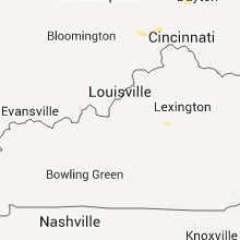
Ohio
| Local Time | Report Details |
|---|---|
| 7:17 PM UTC | A power pole was reported dow in mercer county OH, 48.9 miles SSE of Fort Wayne, IN |
| 7:29 PM UTC | A tree was reported dow in mercer county OH, 49.6 miles SE of Fort Wayne, IN |
| 7:39 PM UTC | Multiple reports of trees down in the versailles area in darke county OH, 67.4 miles SSE of Fort Wayne, IN |
| 7:40 PM UTC | 12 in. diameter tree limbs down. garage destroye in auglaize county OH, 52.4 miles SE of Fort Wayne, IN |
| 7:40 PM UTC | Trees and power poles down. one tree fell onto a garag in auglaize county OH, 52.4 miles SE of Fort Wayne, IN |
| 7:44 PM UTC | Multiple trees down across the count in darke county OH, 69.2 miles SSE of Fort Wayne, IN |
| 7:52 PM UTC | Two power poles blown over blocking roadway. time and location approximate in shelby county OH, 63.8 miles SE of Fort Wayne, IN |
| 7:55 PM UTC | Multiple large tree limbs were reported dow in miami county OH, 65.7 miles N of Cincinnati, OH |
| 7:58 PM UTC | Silo blown down. one tree broke in shelby county OH, 65.7 miles WNW of Columbus, OH |
| 8:00 PM UTC | One tree dow in shelby county OH, 64 miles WNW of Columbus, OH |
| 8:15 PM UTC | Trees and power poles down across the western half of the county in logan county OH, 48.6 miles NW of Columbus, OH |
| 8:18 PM UTC | A mobile home was destroyed... and the debris was blown into a nearby house. the house sustained damage to the roof and garage. a few trees were snapped or downed. maxi in champaign county OH, 47.3 miles WNW of Columbus, OH |
| 8:18 PM UTC | Widespread tree/power line damage across northwest champaign county. at this location...house trailer destroyed with debris thrown into a farm house. roof damage to far in champaign county OH, 47.3 miles WNW of Columbus, OH |
| 8:22 PM UTC | One tree dow in hardin county OH, 60.5 miles NW of Columbus, OH |
| 8:30 PM UTC | Numerous trees/power lines down rosewood to st. paris. house destroyed nr rosewood in champaign county OH, 53.7 miles WNW of Columbus, OH |
| 8:30 PM UTC | Widespread trees/power lines damage across northwest champaign county. at this location...house trailer destroyed with debris thrown into a farm house. roof damage to f in champaign county OH, 46.6 miles WNW of Columbus, OH |
| 8:35 PM UTC | One tree dow in clark county OH, 48.4 miles W of Columbus, OH |
| 8:56 PM UTC | Trees down on power lines in west jefferson area. time estimated from rada in madison county OH, 14.3 miles W of Columbus, OH |
| 9:36 PM UTC | Trees down on lacaster thornville roa in fairfield county OH, 29 miles ESE of Columbus, OH |
| 10:04 PM UTC | Trees down on eaton hollow road. time estimated from rada in fairfield county OH, 30 miles SE of Columbus, OH |
| 10:10 PM UTC | Large limbs down and several trees uprooted in the village of greenhill in hamilton county OH, 11.3 miles N of Cincinnati, OH |
| 10:40 PM UTC | Many trees uprotted/twisted in hocking county OH, 43.3 miles SE of Columbus, OH |
| 10:50 PM UTC | Small branches broke in athens county OH, 66.7 miles SE of Columbus, OH |
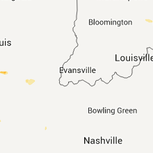
Missouri
| Local Time | Report Details |
|---|---|
| 2:24 PM CDT | 10 to 12 inch tree limbs in platte county MO, 10.2 miles N of Kansas City, MO |
| 2:25 PM CDT | Near 45 highway and interstate 435 at least one large tree blown down as well as nickel sized hai in platte county MO, 11.7 miles NW of Kansas City, MO |
| 2:28 PM CDT | Storm damage reported in platte county MO, 15.4 miles NNW of Kansas City, MO |
| 2:30 PM CDT | Power poles and teres blown down. time estimate in platte county MO, 9.5 miles NNW of Kansas City, MO |
| 7:33 PM UTC | 50 to 60 mph winds in jackson county MO, 3.8 miles NE of Kansas City, MO |
| 2:38 PM CDT | Quarter sized hail reported near Riverside, MO, 5.3 miles NNW of Kansas City, MO, also 60 mph wind with 6 inch dia tree limb down |
| 7:38 PM UTC | Storm damage reported in clay county MO, 8.7 miles NE of Kansas City, MO |
| 2:38 PM CDT | Near lake waukomis...winds of at least 60 mph and snapping tree limb in platte county MO, 9.5 miles NNW of Kansas City, MO |
| 7:40 PM UTC | Storm damage reported in jackson county MO, 12.6 miles E of Kansas City, MO |
| 7:40 PM UTC | Storm damage reported in platte county MO, 4.4 miles NNW of Kansas City, MO |
| 7:45 PM UTC | Storm damage reported in jackson county MO, 4.1 miles ENE of Kansas City, MO |
| 8:14 PM UTC | Up to 12 inch diameter tree branches down. dime size hai in jackson county MO, 25.4 miles ESE of Kansas City, MO |
| 8:23 PM UTC | 60+ mph winds. 8 inch diameter tree branches down. small hai in lafayette county MO, 27.9 miles E of Kansas City, MO |
| 8:25 PM UTC | Up to 12 inch diameter tree branches down. dime size hai in jackson county MO, 25.4 miles ESE of Kansas City, MO |
| 8:40 PM UTC | Storm damage reported in lafayette county MO, 46 miles E of Kansas City, MO |
| 8:48 PM UTC | 60 to 65 mph winds. half a tree down. several large tree branches dow in lafayette county MO, 57.1 miles E of Kansas City, MO |
| 9:18 PM UTC | 6 inch tree limbs blown down at martin warren elementary school. reported by the daily star journal. time estimated from previous report in johnson county MO, 51.2 miles ESE of Kansas City, MO |
| 9:20 PM UTC | 2 to 3 inch tree branches down. pea size hai in johnson county MO, 51.7 miles ESE of Kansas City, MO |
| 9:25 PM UTC | Sustained winds of 45 to 55 mph. a few gusts around 60 mph were also reporte in pettis county MO, 51.4 miles WSW of Columbia, MO |
| 9:28 PM UTC | 50 to 60 mph winds. pea size hail. power outage in saline county MO, 37.6 miles W of Columbia, MO |
| 9:30 PM UTC | Widespread tree damage. numerous trees dow in saline county MO, 37.6 miles W of Columbia, MO |
| 9:50 PM UTC | Barn roof blow in cooper county MO, 22.4 miles W of Columbia, MO |
| 10:00 PM UTC | Many small tree limbs down and dime sized hail in moniteau county MO, 25.6 miles SSW of Columbia, MO |
| 10:05 PM UTC | Power lines down in california...hail of unknown size also reported in moniteau county MO, 25.6 miles SSW of Columbia, MO |
| 10:11 PM UTC | Several 10 to 12 inches tree branches down. garage doors blown off. part of a metal roof curled bac in henry county MO, 76.6 miles N of Springfield, MO |
| 10:14 PM UTC | Half Dollar sized hail reported near Clinton, MO, 76.6 miles N of Springfield, MO |
| 10:17 PM UTC | Quarter sized hail reported near Warsaw, MO, 71.3 miles N of Springfield, MO |
| 10:22 PM UTC | Storm damage reported in boone county MO, 10.4 miles SE of Columbia, MO |
| 10:25 PM UTC | Trees and power lines reported down in jefferson city and elsewhere ni rural cole count in cole county MO, 27.5 miles SSE of Columbia, MO |
| 10:36 PM UTC | Wind gust measured by hand held anemometer...large tree limbs dow in callaway county MO, 20.7 miles SE of Columbia, MO |
| 10:36 PM UTC | Wind gust measured by hand held anemometer...large trees dow in callaway county MO, 20.7 miles SE of Columbia, MO |
| 10:45 PM UTC | Tailer building blown into road near intersection og mo hwys 64 and 65. time estimate in dallas county MO, 38.9 miles NNE of Springfield, MO |
| 10:45 PM UTC | Trailer building blown into road near the intersection of mo hwys 64 and 65. roof blown off of a lumberyard and over the highway. several trees uprooted...several mobil in dallas county MO, 38.9 miles NNE of Springfield, MO |
| 11:20 PM UTC | Limbs dow in greene county MO, 10.4 miles ENE of Springfield, MO |
| 11:20 PM UTC | Tree branches dow in laclede county MO, 32.8 miles NE of Springfield, MO |
| 11:20 PM UTC | Tree branches down. measured by member of oem staff. revises previous repor in laclede county MO, 32.8 miles NE of Springfield, MO |
| 11:20 PM UTC | Limbs down. tree down on a house. a lean to shed attached to a garage lost a roof. winds were estimated at 60 mph by a spotte in greene county MO, 10.4 miles ENE of Springfield, MO |
| 11:45 PM UTC | Small trees damaged...also damage to corn field in wright county MO, 39.8 miles ENE of Springfield, MO |
| 11:50 PM UTC | Tree down on hwy 14 near dogwood. also a public report of high winds. likely outflow from storms to the nort in douglas county MO, 28 miles ESE of Springfield, MO |
| 11:59 PM UTC | Storm damage reported in wright county MO, 38.5 miles ENE of Springfield, MO |
| 12:00 AM UTC | Also tree damage and lawn furniture scattere in wright county MO, 43.8 miles E of Springfield, MO |
| 12:15 AM UTC | Power lines down near hwy 76 and county rd 43 in douglas county MO, 37.9 miles ESE of Springfield, MO |
| 12:35 AM UTC | Storm damage reported in texas county MO, 31.5 miles SW of Salem, MO |
| 12:37 AM UTC | Trees blocking a roadwa in texas county MO, 47.3 miles SW of Salem, MO |
| 12:47 AM UTC | Trees blocking a roadway near willow spring in howell county MO, 50.6 miles SSW of Salem, MO |
| 12:48 AM UTC | Pea sized hail and 1.5 inch tree limbs snappe in washington county MO, 46.6 miles SW of Saint Louis, MO |
| 12:54 AM UTC | 59 kt...68 mph wind gust measured at west plains aso in howell county MO, 56.8 miles SSW of Salem, MO |
| 1:00 AM UTC | Powerlines reported down. also trees down across county roads 1240 and 293 in howell county MO, 44.8 miles SSW of Salem, MO |
| 1:00 AM UTC | Trees down across county road 1990...also several reports of trees on home in howell county MO, 50.6 miles SSW of Salem, MO |
| 1:01 AM UTC | Police dept and city hall have lost their roofs. numerous trees down in the are in shannon county MO, 32.2 miles SSW of Salem, MO |
| 1:27 AM UTC | Trees reported down on powerlines and on a ca in howell county MO, 64.9 miles SSW of Salem, MO |
| 1:34 AM UTC | Storm damage reported in shannon county MO, 47.5 miles SSE of Salem, MO |
| 1:38 AM UTC | Numerous reports on trees on homes and cars. rescues currently underwa in shannon county MO, 44.8 miles SSE of Salem, MO |
| 1:40 AM UTC | *** 1 fatal *** a man was killed from a tree that fell on his car while driving. this occurred on county road 440 one tenth of a mile west of highway 19 about 3 miles n in shannon county MO, 42.2 miles SSE of Salem, MO |
| 2:00 AM UTC | Storm damage reported in ripley county MO, 80.5 miles SSE of Salem, MO |
| 3:29 AM UTC | Dexter law enforcement says there have been reports of trees in stoddard county MO, 41.8 miles SW of Cape Girardeau, MO |
| 3:30 AM UTC | Several trees down in hayti from severe winds associated with thunderstorm gust fron in pemiscot county MO, 69.1 miles W of Mc Kenzie, TN |
| 3:30 AM UTC | Window was blown out of a pharmacy in kennett due to severe wind in dunklin county MO, 75.2 miles N of Memphis, TN |
| 6:30 AM UTC | Quarter sized hail reported near Stover, MO, 59.2 miles SW of Columbia, MO, hail reported along ivy bend road. time and exact location of event is estimated. |
| 6:38 AM UTC | Quarter sized hail reported near Gravois Mills, MO, 56.4 miles SSW of Columbia, MO |
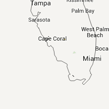
Florida
| Local Time | Report Details |
|---|---|
| 7:39 PM UTC | Coral springs pd reported power line down near woodside d in broward county FL, 37.3 miles N of Miami, FL |
Nebraska
| Local Time | Report Details |
|---|---|
| 8:00 PM UTC | Quarter sized hail reported near Dalton, NE, 47.5 miles SE of Scottsbluff, NE |
| 8:13 PM UTC | Half Dollar sized hail reported near Dalton, NE, 47.5 miles SE of Scottsbluff, NE, hail diameter ranged from one inch to one and one quarter inches. hail has continued since 2 pm. |
| 11:20 PM UTC | Quarter sized hail reported near North Platte, NE, 6.8 miles SE of North Platte, NE, ground covered with hail...largest was quarters. |
| 11:24 PM UTC | Quarter sized hail reported near Paxton, NE, 37.1 miles W of North Platte, NE, public reported quarter sized hail 10 se of roscoe. |
| 12:01 AM UTC | Trained spotter reported winds at 60 mp in dawson county NE, 33.6 miles ESE of North Platte, NE |
| 12:15 AM UTC | Baseball sized hail reported near Kilgore, NE, 22.2 miles WNW of Valentine, NE, also estimated winds blew at least 60mph as the storm passed |
| 12:20 AM UTC | Grain bins...outbuildings...windmills and pivots damaged in cherry county NE, 16.2 miles W of Valentine, NE |
| 12:33 AM UTC | Baseball sized hail reported near Kilgore, NE, 24.4 miles WNW of Valentine, NE, public reported golf ball and baseball sized hail 4 miles northwest of kilgore. |
| 12:35 AM UTC | Public reported that a tree went through a house 5 miles south of kilgore. also reported powerlines and other trees dow in cherry county NE, 20.8 miles W of Valentine, NE |
| 12:40 AM UTC | Golf Ball sized hail reported near Kilgore, NE, 19.3 miles WNW of Valentine, NE |
| 12:50 AM UTC | Building damage reported on the property in cherry county NE, 13.5 miles WSW of Valentine, NE |
| 12:53 AM UTC | Lots of trees down over bush road in cherry county NE, 8 miles WSW of Valentine, NE |
| 1:00 AM UTC | Storm damage reported in cherry county NE, 27.9 miles S of Valentine, NE |
| 1:01 AM UTC | Valentine asos reported thunderstorm wind gust of 58 mp in cherry county NE, 0.3 miles S of Valentine, NE |
| 1:02 AM UTC | Valentine asos reported a thunderstorm wind gust to 77 mp in cherry county NE, 0.3 miles S of Valentine, NE |
| 1:14 AM UTC | Nws raws site near highway 83 in cherry county NE, 27.2 miles S of Valentine, NE |
| 1:15 AM UTC | The very strong winds lasted about 20 min in cherry county NE, 10.1 miles SE of Valentine, NE |
| 1:15 AM UTC | Lots of trees down as well as building damage in cherry county NE, 13 miles SE of Valentine, NE |
| 1:15 AM UTC | Ping Pong Ball sized hail reported near Wood Lake, NE, 10.1 miles SE of Valentine, NE |
| 1:25 AM UTC | Storm damage reported in brown county NE, 35 miles SE of Valentine, NE |
| 1:38 AM UTC | Storm damage reported in arthur county NE, 64 miles NW of North Platte, NE |
| 1:38 AM UTC | Storm damage reported in brown county NE, 35 miles SE of Valentine, NE |
| 1:42 AM UTC | Storm damage reported in brown county NE, 35 miles SE of Valentine, NE |
| 1:50 AM UTC | Powerlines down...power was out in town until 2 am monday morning in rock county NE, 45.9 miles W of Oneill, NE |
| 2:14 AM UTC | Nws raws site along highway 83 in cherry county NE, 27.2 miles S of Valentine, NE |
| 2:29 AM UTC | Public reported 60 mph wind gusts in atkinso in holt county NE, 17.6 miles WNW of Oneill, NE |
| 2:35 AM UTC | Storm damage reported in holt county NE, 1.9 miles NW of Oneill, NE |
| 2:58 AM UTC | Trained spotter reported 60 to 70 mph winds 6 miles west of atkinso in holt county NE, 23.1 miles WNW of Oneill, NE |
| 3:26 AM UTC | Storm damage reported in pierce county NE, 52.6 miles ESE of Oneill, NE |
| 4:00 AM UTC | Storm damage reported in dixon county NE, 78.6 miles S of Sioux Falls, SD |
| 4:00 AM UTC | One-half mile south of allen ne in dixon county NE, 78.6 miles S of Sioux Falls, SD |
| 4:00 AM UTC | Wind rows of hay blown away in dixon county NE, 81.3 miles S of Sioux Falls, SD |
Virginia
| Local Time | Report Details |
|---|---|
| 8:08 PM UTC | Large tree down near intersection of dyke road and big sky lan in greene county VA, 70.9 miles NW of Richmond, VA |
| 8:17 PM UTC | Trees down near intersection of simmons gap road and estes ridg in albemarle county VA, 67.7 miles NW of Richmond, VA |
| 8:19 PM UTC | Trees down near intersection of markwood road and allen roa in albemarle county VA, 67.1 miles NW of Richmond, VA |
| 8:36 PM UTC | Tree down along watts passag in albemarle county VA, 60.2 miles NW of Richmond, VA |
| 8:47 PM UTC | Trees down near intersection of hardwick mountain drive and chestnut lan in orange county VA, 58.2 miles NW of Richmond, VA |
| 8:51 PM UTC | Trees down near intersection of stoney point pass and beasley lan in albemarle county VA, 56.5 miles NW of Richmond, VA |
| 8:52 PM UTC | 2 large trees across jacksontown road near anderson driv in orange county VA, 56.9 miles NNW of Richmond, VA |
| 9:00 PM UTC | Tree down along linney stree in orange county VA, 52.6 miles NNW of Richmond, VA |
Michigan
| Local Time | Report Details |
|---|---|
| 8:49 PM UTC | Power lines down across us 23...townline road...and bay drive. one tree was uprooted and affected a gas line. time estimated from rada in iosco county MI, 54.8 miles S of Alpena, MI |
| 8:50 PM UTC | Tree down at townline road and bay driv in iosco county MI, 54.8 miles S of Alpena, MI |
| 9:00 PM UTC | Fire chief reported damage swath approximately one half mile long by 200 yards wide. damage was 1 mile south of us 23 on douglas drive. roughly 24 trees down and 6 of t in iosco county MI, 54.8 miles S of Alpena, MI |
| 9:00 PM UTC | Oak tree down on a house at 9th st and harris ave. time estimated from rada in iosco county MI, 54.8 miles S of Alpena, MI |
| 11:35 PM UTC | Power lines and trees down throughout lincoln township. partial roof off abandonded house near notre dame avenue. time estimated by rada in berrien county MI, 59.7 miles E of Chicago, IL |
| 11:45 PM UTC | Estimated 18 inch diameter healthy tree blown down. pea sized hail also reporte in berrien county MI, 63.6 miles E of Chicago, IL |
| 12:27 AM UTC | Multiple tree limbs and trees down at the intersection of gumwood dr. and redfield d in cass county MI, 74.2 miles NW of Fort Wayne, IN |
| 12:35 AM UTC | Power lines and trees down throughout lincoln township. partial roof off abandonded house near notre dame avenue. time estimated by rada in berrien county MI, 59.7 miles E of Chicago, IL |
Illinois
| Local Time | Report Details |
|---|---|
| 9:20 PM UTC | 2 to 3 inch tree branches down. pea size hai in macon county IL, 47.8 miles NW of Mattoon, IL |
Georgia
| Local Time | Report Details |
|---|---|
| 10:13 PM UTC | Tree down on power line on amicalola church roa in dawson county GA, 49.9 miles N of Atlanta, GA |
Arizona
| Local Time | Report Details |
|---|---|
| 10:27 PM UTC | Storm damage reported in pima county AZ, 12.4 miles ENE of Tucson, AZ |
| 10:28 PM UTC | Several mesquite trees down near harrison and snyde in pima county AZ, 11.5 miles ENE of Tucson, AZ |
| 10:30 PM UTC | Brick wall blown down near snyder and houghton in pima county AZ, 2.2 miles NE of Tucson, AZ |
Mississippi
| Local Time | Report Details |
|---|---|
| 10:46 PM UTC | Several trees down...power lines down and minor structural damage in a swath from thrashers through towns of altitude and burto in prentiss county MS, 45 miles WSW of Florence, AL |
| 10:48 PM UTC | Roof blown off house number 155 on county road 7481 just south of ms hwy in prentiss county MS, 56.4 miles W of Florence, AL |
| 11:00 PM UTC | 70 mph wind gusts.power lines down and trees down across central to southern parts of prentiss county from blackland to burton. penny sized hail also fel in prentiss county MS, 57.7 miles W of Florence, AL |
| 11:45 PM UTC | Several trees down...power lines down all along tippah and prentiss county border. also dime sized hail fel in tippah county MS, 67.2 miles W of Florence, AL |
| 11:50 PM UTC | Power lines down in town of baldwy in lee county MS, 58.2 miles WSW of Florence, AL |
| 12:00 AM UTC | Several trees down and houses number 122-130 damaged on highway 30 west. no injurie in prentiss county MS, 56.6 miles WSW of Florence, AL |
| 12:00 AM UTC | Multiple trees and power lines reported on county road 6100 in southwest prentiss county. also trees reported on house in prentiss county MS, 59.6 miles WSW of Florence, AL |
| 12:05 AM UTC | Several homes...businesses and vehicles damaged in baldwyn. numerous trees down. search and rescue operations have begun. a large tree fell onto and through house on 5t in lee county MS, 58.2 miles WSW of Florence, AL |
| 12:05 AM UTC | Roof blown off house in north baldwyn. trees down and power lines down als in lee county MS, 58.2 miles WSW of Florence, AL |
| 12:05 AM UTC | Nickel to quarter size hail along with downed trees reported along county road 6061 in southwest prentiss count in prentiss county MS, 59.6 miles WSW of Florence, AL |
| 12:10 AM UTC | Barn blown over on hwy 6100 at the baldwyn city limit in lee county MS, 58.2 miles WSW of Florence, AL |
| 12:15 AM UTC | Roof blown off of a house in the west side of baldwyn along community driv in lee county MS, 58.2 miles WSW of Florence, AL |
| 12:29 AM UTC | Dime to penny size hail and severe winds which overturned a camper was reported in baldwyn with second severe thunderstor in lee county MS, 58.2 miles WSW of Florence, AL |
Wyoming
| Local Time | Report Details |
|---|---|
| 10:53 PM UTC | Storm damage reported in converse county WY, 48.1 miles E of Casper, WY |
Alabama
| Local Time | Report Details |
|---|---|
| 11:05 PM UTC | Trees down on mars hill rd in florenc in lauderdale county AL, 0.3 miles W of Florence, AL |
| 11:05 PM UTC | Trees down on county rd in lauderdale county AL, 4.9 miles N of Florence, AL |
| 11:10 PM UTC | Multiple trees down along locust shores in colbert county AL, 8.1 miles SW of Florence, AL |
| 11:15 PM UTC | 55 to 65 mph wind gusts estimate in franklin county AL, 33.3 miles S of Florence, AL |
| 11:21 PM UTC | Multiple trees and powerlines down. time estimated from rada in colbert county AL, 12 miles SSW of Florence, AL |
| 11:25 PM UTC | 15-20 trees down in joe wheeler state par in lauderdale county AL, 18.6 miles E of Florence, AL |
| 11:33 PM UTC | Tree down on house. no injuries. time estimated from rada in colbert county AL, 11.2 miles S of Florence, AL |
| 11:35 PM UTC | Multiple trees down along colburn mountain road from top of mountain to vandiver hollow road. time estimated from rada in colbert county AL, 12.8 miles SSE of Florence, AL |
| 11:38 PM UTC | Powerlines down and an building overhang was blown away. time estimated from rada in colbert county AL, 15.2 miles S of Florence, AL |
| 12:15 AM UTC | 55 to 65 mph wind gusts estimate in franklin county AL, 33.3 miles S of Florence, AL |
| 12:25 AM UTC | Several trees reported down in hamilto in marion county AL, 48.7 miles SSW of Florence, AL |
| 1:20 AM UTC | Minor roof damage to store. estimated winds of 40 to 50 mp in blount county AL, 33.2 miles NNE of Birmingham, AL |
| 1:35 AM UTC | Tree down on power line in walker county AL, 27.4 miles NW of Birmingham, AL |
| 1:55 AM UTC | Tree down on power line in jefferson county AL, 6.6 miles NW of Birmingham, AL |
| 1:57 AM UTC | Tree down on pratt highway and oak ridge driv in jefferson county AL, 6.6 miles NW of Birmingham, AL |
| 2:10 AM UTC | Trees dow in jefferson county AL, 12.9 miles SW of Birmingham, AL |
South Carolina
| Local Time | Report Details |
|---|---|
| 11:08 PM UTC | Powerlines down off of knollwood court. time estimated from rada in spartanburg county SC, 39.1 miles ENE of Greenville, SC |
| 11:28 PM UTC | Golf Ball sized hail reported near Spartanburg, SC, 40.9 miles ENE of Greenville, SC, customer at drayton post office reported golf ball size hail that damaged her yard. time estimated from radar. |
| 12:31 AM UTC | Quarter sized hail reported near Union, SC, 54.8 miles E of Greenville, SC, fd official/spotter reported quarter size hail and 50 mph wind gust. |
| 12:35 AM UTC | Spotter reported power lines blown down and power poles snapped on n church st...and trees down on park dr. also railroad crossing gates snapped in the bonham are in union county SC, 56.3 miles E of Greenville, SC |
West Virginia
| Local Time | Report Details |
|---|---|
| 11:50 PM UTC | Roof and porch blown off hous in ritchie county WV, 62.6 miles NNE of Charleston, WV |
| 11:53 PM UTC | Tree down across rte 31 near rte 50 in ritchie county WV, 64.7 miles NNE of Charleston, WV |
| 12:00 AM UTC | Large area of uprooted and broken trees. some trees on homes near holbrook roa in ritchie county WV, 60.3 miles WNW of Elkins, WV |
| 12:01 AM UTC | Tree down on a power line between pennsboro and ellenboro in ritchie county WV, 67 miles WNW of Elkins, WV |
| 12:10 AM UTC | Trees and power lines down on holbrook rd in pullman in ritchie county WV, 62.2 miles WNW of Elkins, WV |
| 12:10 AM UTC | Large area of uprooted and broken trees. some trees on homes near holbrook roa in ritchie county WV, 60.3 miles WNW of Elkins, WV |
| 12:11 AM UTC | Two trees down on rte 47 in burnt hous in ritchie county WV, 60 miles NE of Charleston, WV |
| 12:40 AM UTC | Tree down across patterson fork rd in salem in harrison county WV, 46.1 miles WNW of Elkins, WV |
| 12:43 AM UTC | Tree down on simson run rd in lewis county WV, 37.2 miles WNW of Elkins, WV |
| 12:44 AM UTC | Tree and power lines down on rte 19 in weston in lewis county WV, 34.6 miles WNW of Elkins, WV |
| 1:06 AM UTC | Trees and powerlines down on vehicle in mt. clare in harrison county WV, 29.4 miles NW of Elkins, WV |
Tennessee
| Local Time | Report Details |
|---|---|
| 12:26 AM UTC | Spotter in sparta reported large tree limbs broken off by high wind in white county TN, 61.6 miles N of Chattanooga, TN |
| 1:50 AM UTC | Trees and power lines dow in coffee county TN, 51.7 miles WNW of Chattanooga, TN |
Kentucky
| Local Time | Report Details |
|---|---|
| 2:00 AM UTC | 10 miles west of van buren trees reported down in mccracken county KY, 56.5 miles ESE of Cape Girardeau, MO |
North Carolina
| Local Time | Report Details |
|---|---|
| 2:12 AM UTC | One tree down near mile marker 67 on interstate 95 in cumberland county NC, 38.3 miles S of Raleigh, NC |
| 2:23 AM UTC | Powerlines down on river road. relayed from 911 center in beaufort county NC, 92.3 miles E of Raleigh, NC |
| 2:50 AM UTC | One tree down on wilmington highway near highway 87 in cumberland county NC, 58.1 miles SSW of Raleigh, NC |
| 2:55 AM UTC | One tree down on tabor church road near mill creek road in cumberland county NC, 59.5 miles S of Raleigh, NC |
| 3:05 AM UTC | 1 tree reported down on maxwell rd. 1 tree also reportedly fell on a house in the same are in cumberland county NC, 50.9 miles S of Raleigh, NC |
| 3:20 AM UTC | One tree down in salemburg in sampson county NC, 54.1 miles S of Raleigh, NC |
Iowa
| Local Time | Report Details |
|---|---|
| 4:35 AM UTC | Trees down...including one tree on a hous in woodbury county IA, 61.5 miles W of Storm Lake, IA |
| 4:36 AM UTC | Storm damage reported in woodbury county IA, 59.5 miles WSW of Storm Lake, IA |
| 4:38 AM UTC | Several small limbs also dow in woodbury county IA, 60.8 miles WSW of Storm Lake, IA |
| 5:25 AM UTC | Along with heavy rainfall in ida county IA, 36 miles SW of Storm Lake, IA |
Oklahoma
| Local Time | Report Details |
|---|---|
| 8:10 AM UTC | Outbuilding destroyed and antenna damaged. trampoline blown completely over house. winds estimated around 60-65 mp in beaver county OK, 71.7 miles W of Woodward, OK |
Connect with Interactive Hail Maps