

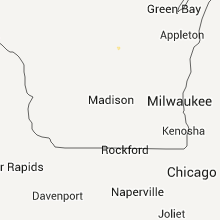
Hail Map for Saturday, August 6, 2011

Number of Impacted Households on 8/6/2011
0
Impacted by 1" or Larger Hail
0
Impacted by 1.75" or Larger Hail
0
Impacted by 2.5" or Larger Hail
Square Miles of Populated Area Impacted on 8/6/2011
0
Impacted by 1" or Larger Hail
0
Impacted by 1.75" or Larger Hail
0
Impacted by 2.5" or Larger Hail

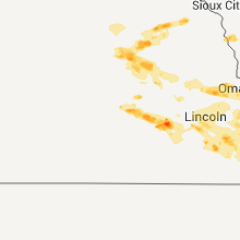


Cities Most Affected by Hail Storms of 8/6/2011
| Hail Size | Demographics of Zip Codes Affected | ||||||
|---|---|---|---|---|---|---|---|
| City | Count | Average | Largest | Pop Density | House Value | Income | Age |
| Omaha, NE | 1 | 1.75 | 1.75 | 5214 | $130k | $36.8k | 30.7 |
| Richmond, MN | 1 | 1.75 | 1.75 | 54 | $109k | $46.0k | 43.0 |
| Norwood Young America, MN | 1 | 1.75 | 1.75 | 54 | $112k | $49.6k | 39.1 |
| Chapman, NE | 1 | 1.75 | 1.75 | 7 | $65k | $38.1k | 43.4 |
| Pierce, NE | 1 | 1.75 | 1.75 | 15 | $69k | $36.7k | 40.9 |
| Kirkman, IA | 1 | 1.75 | 1.75 | 7 | $54k | $43.4k | 50.8 |
Hail and Wind Damage Spotted on 8/6/2011
Filter by Report Type:Hail ReportsWind Reports
States Impacted
Georgia, South Carolina, Florida, Oklahoma, Wisconsin, Nebraska, Missouri, Virginia, Idaho, Mississippi, North Carolina, Ohio, Maine, Minnesota, Colorado, Arkansas, Iowa, Illinois, Kentucky, NevadaGeorgia
| Local Time | Report Details |
|---|---|
| 6:19 PM UTC | Quarter sized hail reported near Thunderbolt, GA, 4.2 miles SE of Savannah, GA, public reported quarter size hail in thunderbolt. also gusty winds with occasional power outages. |
| 7:34 PM UTC | Spotter reported several large trees down in the kingsway subdivision on whitfield av in chatham county GA, 9.1 miles S of Savannah, GA |
| 8:30 PM UTC | The waverly minit mart passed along a report from a customer who had large trees down on property with minor damage to home off county road 17 in brantley county GA, 61.7 miles N of Jacksonville, FL |
South Carolina
| Local Time | Report Details |
|---|---|
| 8:55 PM UTC | Tree down at the intersection of highway 363 and brookwood drive. time estimated based on rada in hampton county SC, 55.1 miles N of Savannah, GA |
| 9:30 PM UTC | Barnwell county sheriff office reported threes down on patterson mill road 3 miles west of barnwell at 530 p in barnwell county SC, 36.1 miles ESE of Augusta, GA |
| 9:30 PM UTC | Barnwell county sheriff office reported trees down on patterson mill road 3 miles west of barnwell at 530 p in barnwell county SC, 36.1 miles ESE of Augusta, GA |
Florida
| Local Time | Report Details |
|---|---|
| 9:00 PM UTC | A tree and powerline reported down by the highway patrol. time of event based on rada in union county FL, 51.5 miles WSW of Jacksonville, FL |
Oklahoma
| Local Time | Report Details |
|---|---|
| 9:35 PM UTC | Storm damage reported in custer county OK, 65.6 miles W of Oklahoma City, OK |
| 10:10 PM UTC | Storm damage reported in payne county OK, 45 miles NE of Oklahoma City, OK |
| 10:15 PM UTC | Storm damage reported in payne county OK, 45 miles NE of Oklahoma City, OK |
| 10:15 PM UTC | Reports of power lines down and structural damage. at least one semi blown over in payne county OK, 46.8 miles NE of Oklahoma City, OK |
| 10:27 PM UTC | Measured by awos in custer county OK, 66.8 miles SSE of Woodward, OK |
| 11:08 PM UTC | Flag pole snapped at local auto dealership and motel sign damaged near i-44 and memoria in tulsa county OK, 4.3 miles ESE of Tulsa, OK |
| 11:29 PM UTC | Thunderstorm wind gust at nws office 11th and 169 estimated 60 miles per hou in tulsa county OK, 4.3 miles ESE of Tulsa, OK |
| 11:30 PM UTC | Several large trees greater than 2 inches in diameter split and blown down at shiloh neighborhood at battle cree in tulsa county OK, 11 miles ESE of Tulsa, OK |
| 11:30 PM UTC | Roof blown off barn. damage to roofs of several mobile homes. large tree limbs broken. ...freedom hill in creek county OK, 22.8 miles WSW of Tulsa, OK |
| 11:32 PM UTC | Spotter reported 60 to 70 mile per hour wind gust and dime hail at savage par in tulsa county OK, 11.7 miles ESE of Tulsa, OK |
| 11:44 PM UTC | 55kt gust measured at the jenks riverside airpor in tulsa county OK, 9 miles S of Tulsa, OK |
| 11:58 PM UTC | Flag pole and trees damaged by thunderstorm wind gust estimated to 65 mph by off duty nws employe in rogers county OK, 25.8 miles E of Tulsa, OK |
| 12:43 AM UTC | Measured by kgok asos in logan county OK, 26.6 miles N of Oklahoma City, OK |
Wisconsin
| Local Time | Report Details |
|---|---|
| 10:12 PM UTC | 2 - 6 inch diameter trees down on cain creek rd near hwy 6 in lincoln county WI, 36 miles S of Rhinelander, WI |
| 11:19 PM UTC | Several trees down and power lines in shawano county WI, 47.8 miles SSE of Rhinelander, WI |
| 11:32 PM UTC | Trees and power lines down in shawano county WI, 48.2 miles WNW of Green Bay, WI |
| 12:18 AM UTC | Storm damage reported in outagamie county WI, 33.7 miles W of Green Bay, WI |
Nebraska
| Local Time | Report Details |
|---|---|
| 10:15 PM UTC | Quarter sized hail reported near St Libory, NE, 13.6 miles N of Grand Island, NE, delayed report. trained spotter reported quarter size hail. |
| 11:10 PM UTC | Golf Ball sized hail reported near Chapman, NE, 13.2 miles ENE of Grand Island, NE |
| 11:23 PM UTC | Quarter sized hail reported near Marquette, NE, 18.2 miles ENE of Grand Island, NE, quarter size hail in marquette |
| 11:33 PM UTC | Quarter sized hail reported near David City, NE, 64.1 miles W of Omaha, NE |
| 12:03 AM UTC | Quarter sized hail reported near York, NE, 38.9 miles E of Grand Island, NE, quarter size hail reported at the fairgrounds in york. |
| 12:10 AM UTC | Quarter sized hail reported near Bartlett, NE, 43.3 miles SSE of Oneill, NE, public reported quarter sized hail 12 miles east of bartlett. |
| 12:15 AM UTC | Storm damage reported in seward county NE, 51.8 miles E of Grand Island, NE |
| 12:35 AM UTC | Half Dollar sized hail reported near Petersburg, NE, 51.1 miles SE of Oneill, NE |
| 12:35 AM UTC | Wind gust strong enough to blow a 200 lb tank across a gas station parking lo in boone county NE, 51.1 miles SE of Oneill, NE |
| 12:43 AM UTC | Half Dollar sized hail reported near Oakdale, NE, 43.9 miles SE of Oneill, NE |
| 12:45 AM UTC | 2-3 inch limbs dow in seward county NE, 67.2 miles WSW of Omaha, NE |
| 12:59 AM UTC | Limbs as large as 3 to 4 inches in diameter broke in saline county NE, 67.2 miles ESE of Grand Island, NE |
| 1:00 AM UTC | Quarter sized hail reported near Oakdale, NE, 43.9 miles SE of Oneill, NE |
| 1:03 AM UTC | 56th and w denton r in lancaster county NE, 49.6 miles SW of Omaha, NE |
| 1:05 AM UTC | Wind gusts of at least 50 to 60 mp in sarpy county NE, 15.9 miles SW of Omaha, NE |
| 1:10 AM UTC | Had shed damage and tree limbs down from strong winds...2.25 inches of rainfall in less than 60 minutes...also had hail /size unknown/ in boone county NE, 58.3 miles NNE of Grand Island, NE |
| 1:15 AM UTC | Near 24th and a st. numerous small branches and one large 12+ inch branch dow in lancaster county NE, 49.6 miles SW of Omaha, NE |
| 1:15 AM UTC | 36 inch tree down on power lines and a house on s 16th st between smith and burk in lancaster county NE, 49.6 miles SW of Omaha, NE |
| 1:15 AM UTC | Tree across a car on s 10th and lake s in lancaster county NE, 49.6 miles SW of Omaha, NE |
| 1:15 AM UTC | Tree on a house on 48th st south of randolp in lancaster county NE, 49.6 miles SW of Omaha, NE |
| 1:15 AM UTC | Tree on power lines on b s in lancaster county NE, 49.6 miles SW of Omaha, NE |
| 1:16 AM UTC | 10 inch tree limb blocking road at 48th and j s in lancaster county NE, 49.6 miles SW of Omaha, NE |
| 1:16 AM UTC | Large limbs blocking road near 56th and south s in lancaster county NE, 49.6 miles SW of Omaha, NE |
| 1:16 AM UTC | Tree blocking road at 40th just north of prescott in lancaster county NE, 49.6 miles SW of Omaha, NE |
| 1:18 AM UTC | Sw corner of city in lancaster county NE, 51.7 miles SW of Omaha, NE |
| 1:20 AM UTC | One foot diameter tree blocking street near 24th and washington s in lancaster county NE, 49.6 miles SW of Omaha, NE |
| 1:22 AM UTC | At the lancaster county event cente in lancaster county NE, 49.6 miles SW of Omaha, NE |
| 1:28 AM UTC | Also nickel size hail. 54th and princeto in lancaster county NE, 49.3 miles SW of Omaha, NE |
| 1:28 AM UTC | Tree down at 25th and e in lancaster county NE, 49.6 miles SW of Omaha, NE |
| 1:29 AM UTC | Tree limbs at least 4 inches in diameter almost blocking highway 50 in southern sarpy count in sarpy county NE, 16.5 miles SW of Omaha, NE |
| 1:30 AM UTC | Golf Ball sized hail reported near Pierce, NE, 60 miles ESE of Oneill, NE |
| 1:36 AM UTC | Large limbs blocking road near 56th and south s in lancaster county NE, 49.6 miles SW of Omaha, NE |
| 1:45 AM UTC | 4 inch diameter tree branches down in platte center in platte county NE, 61.3 miles NE of Grand Island, NE |
| 1:45 AM UTC | 4-6 inch branches down. an 8-10 inch tree down across the road. winds at least 60 mp in otoe county NE, 43.3 miles SSW of Omaha, NE |
| 2:03 AM UTC | Measured at nebraska city airpor in otoe county NE, 40.3 miles S of Omaha, NE |
| 2:08 AM UTC | Significant tree damage around tow in colfax county NE, 59.7 miles WNW of Omaha, NE |
| 2:15 AM UTC | Ping Pong Ball sized hail reported near Pierce, NE, 59 miles ESE of Oneill, NE, most of the hail was quarter-sized...but a few were larger /ping-pong sized/ |
| 2:16 AM UTC | Storm damage reported in otoe county NE, 40.3 miles S of Omaha, NE |
| 2:35 AM UTC | Storm damage reported in saunders county NE, 36.1 miles WNW of Omaha, NE |
| 2:47 AM UTC | Measured at the nws office in valle in douglas county NE, 22.2 miles W of Omaha, NE |
| 2:54 AM UTC | Measured at the nws office in valle in douglas county NE, 22.2 miles W of Omaha, NE |
| 2:57 AM UTC | Measured at the nws office in valley. third strong gust associated with the stor in douglas county NE, 21.6 miles W of Omaha, NE |
| 2:57 AM UTC | Measured at the nws office in valley. third strong gust associated with the stor in douglas county NE, 22.2 miles W of Omaha, NE |
| 2:58 AM UTC | Quarter sized hail reported near Randolph, NE, 66.1 miles E of Oneill, NE |
| 3:05 AM UTC | Storm damage reported in douglas county NE, 13.7 miles WNW of Omaha, NE |
| 3:15 AM UTC | Golf Ball sized hail reported near Omaha, NE, 3.6 miles W of Omaha, NE, at 63rd and emmet. |
| 3:28 AM UTC | Strong winds up to 60 mph. very heavy rain and some hai in dixon county NE, 78.8 miles S of Sioux Falls, SD |
| 5:42 AM UTC | Quarter sized hail reported near Lincoln, NE, 49.6 miles SW of Omaha, NE, one inch hail lasted for 2 minutes near 58th and r |
| 8:53 AM UTC | Ping Pong Ball sized hail reported near Auburn, NE, 60.3 miles S of Omaha, NE |
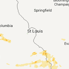
Missouri
| Local Time | Report Details |
|---|---|
| 10:35 PM UTC | Report of a billboard snapped...tree split...and roof damage to a business in the kimberling city area. power also reported out in kimberling city. time of damage betwe in stone county MO, 40.6 miles S of Springfield, MO |
| 10:37 PM UTC | Roof damage to the white oak inn. also a billboard was blown over in tow in stone county MO, 35.4 miles S of Springfield, MO |
| 2:41 AM UTC | 2.0 miles south of hamburg ia. in missouri on mo hw in atchison county MO, 49.4 miles SSE of Omaha, NE |
| 2:45 AM UTC | Report of damage to several homes in the billings area...as well as tree damage. power is reported out in the are in christian county MO, 17.2 miles SW of Springfield, MO |
| 2:50 AM UTC | Multiple power lines down. fire dept estimated 60 mph winds. time estimated from rada in nodaway county MO, 70.4 miles SE of Omaha, NE |
| 3:02 AM UTC | Windows blown out of a house. time estimated from rada in nodaway county MO, 79.6 miles SE of Omaha, NE |
| 3:05 AM UTC | Powerline downed at hwy 136 and hwy f in nodaway county MO, 86.1 miles N of Kansas City, MO |
| 3:10 AM UTC | Trees reported down along route 19 north of greer between eleven point river bridge and shannon county lin in oregon county MO, 60.6 miles S of Salem, MO |
| 3:50 AM UTC | Couple of small trees down 2 miles south of ellsinor in carter county MO, 66.8 miles SE of Salem, MO |
| 4:08 AM UTC | Storm damage reported in harrison county MO, 85.2 miles SSW of Des Moines, IA |
| 4:28 AM UTC | Half Dollar sized hail reported near Zalma, MO, 35.5 miles WSW of Cape Girardeau, MO, up to half dollar size hail reported on hwy tt near gipsy. |
| 5:07 AM UTC | 51 knot...59 mph winds reported from cape girardeau airport automated observation sit in cape girardeau county MO, 0.6 miles NNW of Cape Girardeau, MO |
Virginia
| Local Time | Report Details |
|---|---|
| 11:15 PM UTC | Also reported dime size hail and a few five to six inch diameter limbs dow in pittsylvania county VA, 61.3 miles SE of Roanoke, VA |
Idaho
| Local Time | Report Details |
|---|---|
| 11:23 PM UTC | Trained spotter reports poplar trees blown down in cassia county ID, 39.1 miles ESE of Twin Falls, ID |
| 12:35 AM UTC | Storm damage reported in cassia county ID, 61.8 miles E of Twin Falls, ID |
Mississippi
| Local Time | Report Details |
|---|---|
| 11:53 PM UTC | Power lines down in clinton in hinds county MS, 9.2 miles WNW of Jackson, MS |
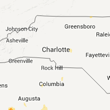
North Carolina
| Local Time | Report Details |
|---|---|
| 12:00 AM UTC | 1 tree reported down on palestine r in stanly county NC, 39.7 miles ENE of Charlotte, NC |
| 12:00 AM UTC | 1 tree reported down on moonshine d in montgomery county NC, 41.9 miles ENE of Charlotte, NC |
Ohio
| Local Time | Report Details |
|---|---|
| 12:01 AM UTC | Storm damage reported in wood county OH, 77.4 miles ENE of Fort Wayne, IN |
Maine
| Local Time | Report Details |
|---|---|
| 12:02 AM UTC | Trees down on route 16 in aroostook county ME, 46.7 miles WNW of Caribou, ME |
Minnesota
| Local Time | Report Details |
|---|---|
| 12:19 AM UTC | Quarter sized hail reported near Richmond, MN, 67.8 miles ENE of Montevideo, MN, 1 inch hail reported near hwy 23. |
| 12:20 AM UTC | Ping Pong Ball sized hail reported near Watkins, MN, 63.6 miles WNW of Minneapolis, MN, golfball to ping pong size hail reported for approximately 10 minutes. |
| 12:27 AM UTC | Quarter sized hail reported near Litchfield, MN, 59.3 miles ENE of Montevideo, MN, occurred near intersection of county roads 22 and 12. |
| 12:27 AM UTC | Golf Ball sized hail reported near Richmond, MN, 67.8 miles ENE of Montevideo, MN |
| 1:30 AM UTC | Ping Pong Ball sized hail reported near Silver Lake, MN, 48.4 miles W of Minneapolis, MN, quarter to ping-pong size hail reported near 220th st. |
| 2:15 AM UTC | Golf Ball sized hail reported near Norwood Young America, MN, 35.3 miles WSW of Minneapolis, MN, golf ball size hail reported near hwy 212. |
| 2:23 AM UTC | Quarter sized hail reported near Norwood Young America, MN, 35.7 miles WSW of Minneapolis, MN, quarter sized hail reported. |
Colorado
| Local Time | Report Details |
|---|---|
| 12:27 AM UTC | Saguache municipal airport in saguache county CO, 85.6 miles W of Pueblo, CO |
| 2:18 AM UTC | Quarter sized hail reported near Akron, CO, 25.9 miles W of Yuma, CO |
Arkansas
| Local Time | Report Details |
|---|---|
| 12:30 AM UTC | 2-3 inch live tree limbs snapped...lots of smaller limbs and leaves covering the roads. time estimated based on rada in carroll county AR, 67.8 miles SSW of Springfield, MO |
| 2:00 AM UTC | Trees were blown dow in marion county AR, 71.7 miles SSE of Springfield, MO |
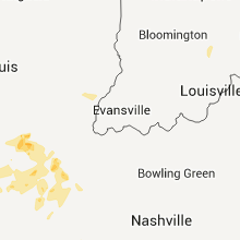
Iowa
| Local Time | Report Details |
|---|---|
| 12:30 AM UTC | Quarter sized hail reported near Moorhead, IA, 45.7 miles N of Omaha, NE |
| 1:30 AM UTC | Golf Ball sized hail reported near Kirkman, IA, 47.5 miles NE of Omaha, NE, hail broke windshields. was at least golfball size. relayed by emergency manager. |
| 1:31 AM UTC | Storm damage reported in mills county IA, 17.1 miles SSE of Omaha, NE |
| 1:35 AM UTC | Tree branches dow in mills county IA, 17.1 miles SSE of Omaha, NE |
| 1:49 AM UTC | Quarter sized hail reported near , , 57.5 miles ENE of Omaha, NE, trained spotter reports hail fell from 849 to 854 pm...mostly peas at first but then up to quarters. |
| 1:50 AM UTC | Numerous large tree limbs dow in mills county IA, 28.8 miles SE of Omaha, NE |
| 1:58 AM UTC | Estimated gusts of 60 mph...small limbs down in audubon county IA, 53.4 miles ENE of Omaha, NE |
| 1:58 AM UTC | Quarter sized hail reported near Kimballton, IA, 53.4 miles ENE of Omaha, NE |
| 2:01 AM UTC | Quarter sized hail reported near , , 57.5 miles ENE of Omaha, NE, trained spotter reports nickel to quarter sized hail fell from 901 to 908 pm. |
| 2:10 AM UTC | Gust tore the door off the bar in montgomery county IA, 43.9 miles ESE of Omaha, NE |
| 2:15 AM UTC | Gust tore the door off the bar in montgomery county IA, 43.9 miles ESE of Omaha, NE |
| 2:20 AM UTC | Winds at least 60 mph. tree down on north side of tow in fremont county IA, 47.4 miles SSE of Omaha, NE |
| 2:30 AM UTC | Adair idot rwis site in cass county IA, 57.7 miles W of Des Moines, IA |
| 2:41 AM UTC | 1.5 miles south of hamburg ia. in missouri on mo hw in fremont county IA, 48.7 miles SSE of Omaha, NE |
| 2:50 AM UTC | Large tree limb fell on power line...causing it to fall on a truck. time estimated from rada in cass county IA, 49.3 miles ENE of Omaha, NE |
| 3:10 AM UTC | Tree limbs down. 4-6 inches in diameter. delayed report. time estimate in adams county IA, 65.4 miles ESE of Omaha, NE |
| 3:20 AM UTC | Lots of...at minimum...3 to 4 inch diameter tree branches down in council bluffs...and the power went out in council bluffs too in pottawattamie county IA, 4.4 miles ESE of Omaha, NE |
| 3:22 AM UTC | Metal sheds dented from the winds...part of the roof peeled off and many large limbs dow in adair county IA, 48.8 miles SW of Des Moines, IA |
| 3:23 AM UTC | Roof torn off a hog house and a large tree down on a trailer at the intersection of 310th street and henry a. wallace roa in adair county IA, 48 miles SW of Des Moines, IA |
| 3:31 AM UTC | Trained spotter reports a measured wind gust of 71 mph...trees uprooted on the west side of creston with damage to some roof in union county IA, 53.9 miles SW of Des Moines, IA |
| 3:33 AM UTC | Tree fell on hous in union county IA, 53.3 miles SW of Des Moines, IA |
| 3:33 AM UTC | Roof damage to american legion building. time estimate in madison county IA, 39.7 miles SW of Des Moines, IA |
| 3:39 AM UTC | Kcci schoolnet in union county IA, 48.5 miles SW of Des Moines, IA |
| 3:39 AM UTC | Torrential rains and limited visibilit in adair county IA, 46.8 miles WSW of Des Moines, IA |
| 3:40 AM UTC | From idot rwis site in union county IA, 51.9 miles SW of Des Moines, IA |
| 3:42 AM UTC | Trained spotter reports wind gusts to around 70 mph lasting for quite some time. multiple large trees down...some on houses. also dime to nickel hai in clarke county IA, 41.1 miles SSW of Des Moines, IA |
| 3:42 AM UTC | 20 by 10 foot shed blown over on its side. 50 by 12 foot mobile home suffered major roof damag in clarke county IA, 41.1 miles SSW of Des Moines, IA |
| 3:42 AM UTC | 6 foot diameter tree sheared off near the base...25 foot flag pole snapped...a few street signs mangled and numerous 2 to 4 inch diameter limbs down across tow in clarke county IA, 41.1 miles SSW of Des Moines, IA |
| 3:56 AM UTC | Storm damage reported in madison county IA, 26.7 miles SW of Des Moines, IA |
| 4:01 AM UTC | Storm damage reported in clarke county IA, 38.4 miles S of Des Moines, IA |
| 4:02 AM UTC | Storm damage reported in decatur county IA, 67.9 miles SSW of Des Moines, IA |
| 4:34 AM UTC | Trees and power lines down. estimated 60 to 70 mph winds. wind blows for several minute in warren county IA, 16 miles S of Des Moines, IA |
| 4:49 AM UTC | Walmart supercenter had a large window blown ou in marion county IA, 32.6 miles SE of Des Moines, IA |
| 4:50 AM UTC | Camper blown off its jacks in lucas county IA, 39.1 miles SSE of Des Moines, IA |
| 4:55 AM UTC | Post event survey reports numerous large limbs...portions of trees...and even a few large trees taken down along with a few power line in monroe county IA, 57.4 miles SE of Des Moines, IA |
| 5:04 AM UTC | Storm damage reported in monroe county IA, 57.4 miles SE of Des Moines, IA |
| 5:20 AM UTC | Police reporting power pole and lines down on south side of ottumwa. time estimate in wapello county IA, 55.3 miles NW of Kahoka, MO |
| 5:22 AM UTC | Storm damage reported in wapello county IA, 61.1 miles NW of Kahoka, MO |
| 5:42 AM UTC | Quarter sized hail reported near Lincoln, IA, 55.8 miles WNW of Cedar Rapids, IA, one inch hail lasted for 2 minutes near 58th and r |
| 5:55 AM UTC | Large trees down. relayed from scanner traffi in wapello county IA, 55.3 miles NW of Kahoka, MO |
| 5:55 AM UTC | Utility poles blown down in fairfiel in jefferson county IA, 42.7 miles NNW of Kahoka, MO |
| 6:20 AM UTC | Dugout sheds blown off field and into a road at stewart elementary school in washingto in washington county IA, 46.7 miles S of Cedar Rapids, IA |
| 8:14 AM UTC | Winds of 60 to 65 mph produced widespread tree damage in the town of hampton. numerous trees and limbs downed through town. many locations without power due to branches in franklin county IA, 28.1 miles S of Mason City, IA |
Illinois
| Local Time | Report Details |
|---|---|
| 4:55 AM UTC | Camper blown over...roof off house on main st in gorham. lots of debris on main stree in jackson county IL, 29 miles N of Cape Girardeau, MO |
| 4:55 AM UTC | Several roofs off houses near main street and one garage now missin in jackson county IL, 29 miles N of Cape Girardeau, MO |
| 6:00 AM UTC | Awning ripped off campe in massac county IL, 38.3 miles E of Cape Girardeau, MO |
| 7:22 AM UTC | Rwis located on i-74 bridge in rock island county IL, 66.9 miles ESE of Cedar Rapids, IA |
Kentucky
| Local Time | Report Details |
|---|---|
| 6:28 AM UTC | Large tree limbs down...blocking part of lone oak road in front of verizon stor in mccracken county KY, 51.5 miles ESE of Cape Girardeau, MO |
| 6:50 AM UTC | Large tree branch fell on home. damage unknown at this tim in graves county KY, 42.5 miles N of Mc Kenzie, TN |
Nevada
| Local Time | Report Details |
|---|---|
| 7:42 AM UTC | Long hollow raws -- 5820 ft amsl in elko county NV, 54 miles NNW of Elko, NV |
Connect with Interactive Hail Maps