

Hail Map for Wednesday, August 9, 2017

Number of Impacted Households on 8/9/2017
0
Impacted by 1" or Larger Hail
0
Impacted by 1.75" or Larger Hail
0
Impacted by 2.5" or Larger Hail
Square Miles of Populated Area Impacted on 8/9/2017
0
Impacted by 1" or Larger Hail
0
Impacted by 1.75" or Larger Hail
0
Impacted by 2.5" or Larger Hail


Cities Most Affected by Hail Storms of 8/9/2017
| Hail Size | Demographics of Zip Codes Affected | ||||||
|---|---|---|---|---|---|---|---|
| City | Count | Average | Largest | Pop Density | House Value | Income | Age |
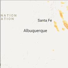
| Las Vegas, NM | 5 | 2.15 | 2.75 | 11 | $89k | $25.9k | 38.7 |
| Medicine Lodge, KS | 1 | 4.25 | 4.25 | 8 | $40k | $34.5k | 42.6 |
| Watertown, SD | 1 | 1.75 | 1.75 | 78 | $86k | $36.2k | 37.5 |
| Albert, KS | 1 | 1.75 | 1.75 | 2 | $44k | $37.1k | 50.2 |
| Wagon Mound, NM | 1 | 1.75 | 1.75 | 0 | $25k | $22.0k | 50.8 |
| Hoisington, KS | 1 | 1.75 | 1.75 | 15 | $43k | $29.3k | 41.7 |
Hail and Wind Damage Spotted on 8/9/2017
Filter by Report Type:Hail ReportsWind Reports
States Impacted
Georgia, Florida, North Dakota, Michigan, Kansas, Nebraska, Mississippi, California, New Mexico, South Dakota, Oklahoma, UtahGeorgia
| Local Time | Report Details |
|---|---|
| 1:08 PM EDT | Tree reported down at intersection of canoochee rd and hwy 19 in emanuel county GA, 57 miles SSW of Augusta, GA |
| 1:15 PM EDT | Tree reported down at the intersection of george l. smith state park rd and u.s. highway 8 in emanuel county GA, 62.6 miles S of Augusta, GA |
Florida
| Local Time | Report Details |
|---|---|
| 3:19 PM EDT | Wind gust of 61 mph measured at jacksonville executive airport at crai in duval county FL, 8.7 miles E of Jacksonville, FL |
| 4:00 PM EDT | Central dispatch reported a tree down on eden loop church road in the brooker are in bradford county FL, 50.1 miles SW of Jacksonville, FL |
| 4:30 PM EDT | Central dispatch reported a tree down on a powerline on south county road 231 near sw 69th trai in union county FL, 48.6 miles WSW of Jacksonville, FL |
North Dakota
| Local Time | Report Details |
|---|---|
| 2:55 PM CDT | Half Dollar sized hail reported near Spiritwood, ND, 72.3 miles W of Fargo, ND, large hail didnt cover the ground but a few were quarter sized or a bit bigger. |
| 3:25 PM CDT | Quarter sized hail reported near Oriska, ND, 51.8 miles WNW of Fargo, ND, a few nickel to quarter sized hail in heavy rains across northern noltimier township. |
| 4:43 PM CDT | Quarter sized hail reported near Enderlin, ND, 38.4 miles WSW of Fargo, ND, very heavy rain and strong winds along with hail nearly covering the ground across central clifton township. a few of the largest hail were nickel to quarter sized. mos |
Michigan
| Local Time | Report Details |
|---|---|
| 4:37 PM EDT | Ping Pong Ball sized hail reported near Trenary, MI, 33.1 miles SE of Marquette, MI, report via picture on social media. |
| 4:45 PM EDT | Ping Pong Ball sized hail reported near Trenary, MI, 32.2 miles SE of Marquette, MI, picture of near golf ball sized hail near trenary via social media. hail fell for about 20 minutes. strong winds also observed. |
Kansas
| Local Time | Report Details |
|---|---|
| 3:57 PM CDT | Golf Ball sized hail reported near Hoisington, KS, 38.4 miles SE of Hays, KS |
| 4:00 PM CDT | Quarter sized hail reported near Hoisington, KS, 38.4 miles SE of Hays, KS |
| 4:35 PM CDT | Golf Ball sized hail reported near Albert, KS, 33.9 miles SSE of Hays, KS |
| 6:30 PM CDT | Half Dollar sized hail reported near Prairie View, KS, 68 miles NNW of Hays, KS |
| 6:57 PM CDT | Grapefruit sized hail reported near Medicine Lodge, KS, 71.7 miles NE of Woodward, OK |
| 7:37 PM CDT | Storm damage reported in barber county KS, 67.2 miles NE of Woodward, OK |
Nebraska
| Local Time | Report Details |
|---|---|
| 4:04 PM CDT | Oberrver reported that texas instruments equipment was reporting sustained 40mph and gusts to 60mp in frontier county NE, 50.5 miles SE of North Platte, NE |
| 4:04 PM CDT | Quarter sized hail reported near Eustis, NE, 46.5 miles SE of North Platte, NE, 1 inch hail reported by public 10wsw eustis 430pm cdt. |
| 5:05 PM CDT | Estimated 60 mph wind. 2 inch tree limbs down. near zero visibility in heavy rain. no hai in furnas county NE, 68.8 miles SE of North Platte, NE |
Mississippi
| Local Time | Report Details |
|---|---|
| 4:08 PM CDT | A tree was on a car on county road 363. estimated winds of 30-40 mp in clarke county MS, 77.3 miles E of Jackson, MS |
| 7:15 PM CDT | Trees & powerlines down on palmer road & burnt bridge roa in jones county MS, 74.2 miles SE of Jackson, MS |
California
| Local Time | Report Details |
|---|---|
| 2:30 PM PDT | Quarter sized hail reported near Mad River, CA, 57.2 miles WSW of Redding, CA |
| 4:20 PM PDT | Quarter sized hail reported near Old Station, CA, 48.7 miles E of Redding, CA, hail covered the ground.... some hail stones were as large as an inch. |
New Mexico
| Local Time | Report Details |
|---|---|
| 3:45 PM MDT | Golf Ball sized hail reported near Las Vegas, NM, 63.6 miles SSE of Taos, NM |
| 3:50 PM MDT | Golf Ball sized hail reported near Las Vegas, NM, 59.4 miles SSE of Taos, NM |
| 3:50 PM MDT | Baseball sized hail reported near Las Vegas, NM, 59.4 miles SSE of Taos, NM, report from new mexico highlands university. |
| 5:04 PM MDT | Golf Ball sized hail reported near Wagon Mound, NM, 54 miles ESE of Taos, NM |
| 6:54 PM MDT | Baseball sized hail reported near Las Vegas, NM, 51 miles NW of Tucumcari, NM |
| 8:00 PM MDT | Golf Ball sized hail reported near Las Vegas, NM, 51 miles NW of Tucumcari, NM |
South Dakota
| Local Time | Report Details |
|---|---|
| 5:47 PM CDT | Quarter sized hail reported near Roslyn, SD, 48.5 miles E of Aberdeen, SD, mostly dime sized hail with a few up to quarter size. |
| 6:07 PM CDT | Quarter sized hail reported near Waubay, SD, 59.2 miles E of Aberdeen, SD, mostly nickles with a few quarters sized hailstones. radar estimated time. |
| 6:40 PM CDT | Golf Ball sized hail reported near Watertown, SD, 70.3 miles W of Montevideo, MN, 50-60 mph winds as well. |
| 6:55 PM CDT | Quarter sized hail reported near Watertown, SD, 61.6 miles W of Montevideo, MN |
Oklahoma
| Local Time | Report Details |
|---|---|
| 9:25 PM CDT | Power lines downed by strong winds near the 5500 block of chestnut avenu in garfield county OK, 68.8 miles NNW of Oklahoma City, OK |
| 9:33 PM CDT | Storm damage reported in garfield county OK, 67.3 miles NNW of Oklahoma City, OK |
Utah
| Local Time | Report Details |
|---|---|
| 10:28 PM MDT | Mesonet station e3712... maese in uintah county UT, 79.8 miles SSW of Rock Springs, WY |
Connect with Interactive Hail Maps