

Hail Map for Friday, January 10, 2020

Number of Impacted Households on 1/10/2020
0
Impacted by 1" or Larger Hail
0
Impacted by 1.75" or Larger Hail
0
Impacted by 2.5" or Larger Hail
Square Miles of Populated Area Impacted on 1/10/2020
0
Impacted by 1" or Larger Hail
0
Impacted by 1.75" or Larger Hail
0
Impacted by 2.5" or Larger Hail


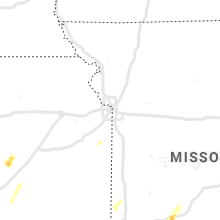
Cities Most Affected by Hail Storms of 1/10/2020
| Hail Size | Demographics of Zip Codes Affected | ||||||
|---|---|---|---|---|---|---|---|
| City | Count | Average | Largest | Pop Density | House Value | Income | Age |
| Tahlequah, OK | 1 | 1.75 | 1.75 | 105 | $68k | $25.4k | 30.6 |
| Hico, TX | 1 | 1.75 | 1.75 | 10 | $51k | $31.3k | 43.4 |
| Decatur, AR | 1 | 1.75 | 1.75 | 56 | $68k | $34.7k | 33.1 |
| Springfield, MO | 1 | 1.75 | 1.75 | 684 | $67k | $28.2k | 32.2 |
| Leedey, OK | 1 | 1.75 | 1.75 | 2 | $26k | $32.1k | 45.3 |
Hail and Wind Damage Spotted on 1/10/2020
Filter by Report Type:Hail ReportsWind Reports
Oklahoma
| Local Time | Report Details |
|---|---|
| 7:42 AM CST | Golf Ball sized hail reported near Leedey, OK, 36.8 miles S of Woodward, OK |
| 8:10 AM CST | Quarter sized hail reported near Vici, OK, 24.7 miles SSE of Woodward, OK |
| 8:15 AM CST | Quarter sized hail reported near Chester, OK, 40.4 miles ESE of Woodward, OK |
| 8:20 AM CST | Quarter sized hail reported near Mutual, OK, 19 miles SE of Woodward, OK |
| 9:45 AM CST | Quarter sized hail reported near Kingfisher, OK, 38.3 miles NW of Oklahoma City, OK |
| 9:45 AM CST | Quarter sized hail reported near Kingfisher, OK, 38.8 miles NW of Oklahoma City, OK |
| 10:23 AM CST | Quarter sized hail reported near Waukomis, OK, 57.7 miles NNW of Oklahoma City, OK |
| 11:32 AM CST | Quarter sized hail reported near Tulsa, OK, 4.3 miles ESE of Tulsa, OK, observed at oru |
| 11:33 AM CST | Quarter sized hail reported near Tulsa, OK, 4.3 miles ESE of Tulsa, OK, reported around the 6500 block of south lewis |
| 2:57 PM CST | Report of tree damage... possible roof damag in cherokee county OK, 43.4 miles NW of Fort Smith, AR |
| 3:02 PM CST | Golf Ball sized hail reported near Tahlequah, OK, 48.1 miles NW of Fort Smith, AR |
| 4:09 PM CST | Spotter report of thunderstorm winds gusting to near 70 mph. also reported power poles and trees down in tow in sequoyah county OK, 21.4 miles WNW of Fort Smith, AR |
Missouri
| Local Time | Report Details |
|---|---|
| 1:47 PM CST | Funnel cloud reported in this area. le reports houses damaged by possible tornado. time based on rada in vernon county MO, 61.3 miles NW of Springfield, MO |
| 2:30 PM CST | 203 highway 32 2 barns destroye in polk county MO, 33.6 miles NNW of Springfield, MO |
| 5:29 PM CST | Quarter sized hail reported near Springfield, MO, 3.8 miles W of Springfield, MO, public report of quarter size hail. |
| 5:30 PM CST | Quarter sized hail reported near Springfield, MO, 4.5 miles WSW of Springfield, MO, report from mping: quarter (1.00 in.). |
| 5:34 PM CST | Quarter sized hail reported near Springfield, MO, 4.3 miles SW of Springfield, MO, report of quarter size hail near golden ave and scenic ave. |
| 5:40 PM CST | Golf Ball sized hail reported near Springfield, MO, 3.4 miles E of Springfield, MO, delayed report and picture of golf ball sized hail on east side of springfield. |
| 5:42 PM CST | Half Dollar sized hail reported near Springfield, MO, 2.8 miles NE of Springfield, MO, report of half dollar sized hail. |
| 5:43 PM CST | Quarter sized hail reported near Springfield, MO, 2.8 miles NE of Springfield, MO, quarter hail on glenstone avenue near i-44 in springfield. |
| 5:50 PM CST | Damage to business and roofs on multiple homes in a path through strafford. possible tornad in greene county MO, 10.4 miles ENE of Springfield, MO |
| 5:57 PM CST | Quarter sized hail reported near Springfield, MO, 2.9 miles ENE of Springfield, MO, report from mping: quarter (1.00 in.). |
| 6:46 PM CST | Quarter sized hail reported near Lebanon, MO, 47.6 miles NE of Springfield, MO |
| 6:48 PM CST | Report of 60-70 mph winds in seymou in webster county MO, 29.1 miles E of Springfield, MO |
| 9:42 PM CST | Report of damage to the roof of a store along highway 5 near the missouri and arkansas state lin in ozark county MO, 66.1 miles SE of Springfield, MO |
| 10:44 PM CST | Report of 60 mph wind gust in peace valle in howell county MO, 56.2 miles SSW of Salem, MO |
| 11:30 PM CST | Dispatch reports trees and power lines down in multiple location in reynolds county MO, 34.4 miles ESE of Salem, MO |
| 1:48 AM CST | Four buildings on birk lane damaged... including roof damage to crader tir in cape girardeau county MO, 4.9 miles NW of Cape Girardeau, MO |
| 1:55 AM CST | Tree blown down on house in tow in cape girardeau county MO, 0.6 miles NNW of Cape Girardeau, MO |
Texas
| Local Time | Report Details |
|---|---|
| 2:51 PM CST | Quarter sized hail reported near Gainesville, TX, 72.8 miles NNW of Dallas, TX, quarter size hail reported at moss lake. time estimated via radar. |
| 3:30 PM CST | Rv blown over. roof damage to home and outbuildings on fm road 51 south of er in cooke county TX, 57.7 miles NNW of Dallas, TX |
| 4:50 PM CST | Half Dollar sized hail reported near Llano, TX, 64.8 miles WSW of Killeen, TX, public report of half dollar size hail south of llano from facebook. |
| 5:08 PM CST | Golf Ball sized hail reported near Hico, TX, 52.7 miles NNW of Killeen, TX, golf ball size hail reported in the community of fairy. |
| 5:39 PM CST | Ping Pong Ball sized hail reported near Lampasas, TX, 27 miles W of Killeen, TX, ping pong ball size hail reported in lampasas. time estimated via radar. |
| 5:43 PM CST | Estimated wind gust to 60 mp in lampasas county TX, 28.7 miles W of Killeen, TX |
| 6:01 PM CST | Ping Pong Ball sized hail reported near Fort Worth, TX, 30 miles WSW of Dallas, TX, ping pong ball size hail reported at everman high school. |
| 6:30 PM CST | Quarter sized hail reported near Gatesville, TX, 21.6 miles N of Killeen, TX, quarter size hail reported in gatesville. |
| 6:45 PM CST | Damage to signs and brick facades near i-635 and macarthur blv in dallas county TX, 7.8 miles WNW of Dallas, TX |
| 6:47 PM CST | Semi truck overturned on i-635 at macarthur blv in dallas county TX, 7.8 miles WNW of Dallas, TX |
| 6:55 PM CST | Quarter sized hail reported near Frisco, TX, 27.3 miles N of Dallas, TX, quarter size hail reported near hackberry via mping. |
| 7:20 PM CST | Half Dollar sized hail reported near Devine, TX, 32.1 miles WSW of San Antonio, TX |
| 7:23 PM CST | Quarter sized hail reported near Blanco, TX, 46.7 miles N of San Antonio, TX |
| 7:26 PM CST | Quarter sized hail reported near Blanco, TX, 48.9 miles N of San Antonio, TX, report from mping: quarter (1.00 in.). |
| 7:31 PM CST | Wind damage reported near von ormy to a residence and trampolin in bexar county TX, 14.5 miles SW of San Antonio, TX |
| 7:38 PM CST | Corrects previous tstm wnd gst report from 2 se universal city. wind gust to 57 kt at ksk in bexar county TX, 6 miles WSW of San Antonio, TX |
| 7:39 PM CST | Carports blown down. gas station sign blown dow in bexar county TX, 5.2 miles SSW of San Antonio, TX |
| 7:41 PM CST | Wind gust to 57 kt at ksk in bexar county TX, 14.8 miles ENE of San Antonio, TX |
| 7:48 PM CST | Recorded at kssf - stinson airpor in bexar county TX, 6 miles SSE of San Antonio, TX |
| 7:54 PM CST | Quarter sized hail reported near San Antonio, TX, 16 miles NNE of San Antonio, TX |
| 7:56 PM CST | Recorded at krnd - randolph af in bexar county TX, 14.8 miles ENE of San Antonio, TX |
| 8:05 PM CST | Collapse of awning at busines in bexar county TX, 15 miles ESE of San Antonio, TX |
| 8:19 PM CST | 53 kt wind gust at san marcos airport awo in caldwell county TX, 49.4 miles NE of San Antonio, TX |
| 8:20 PM CST | Corrects previous tstm wnd dmg report from 1 nne kyle. siding blown off side of home and storage pod flipped ove in hays county TX, 55.1 miles NE of San Antonio, TX |
| 8:20 PM CST | Corrects location of previous tstm wnd dmg report from 1 nne kyle. siding blown off side of home and storage pod flipped ove in hays county TX, 54 miles NE of San Antonio, TX |
| 8:31 PM CST | Two 18-wheelers blown over on sh-130 just north of lockhar in caldwell county TX, 59.7 miles NE of San Antonio, TX |
| 9:28 PM CST | 18 wheeler blown over on u.s. 77 near warda. also reports of numerous trees over nearby road in fayette county TX, 87.6 miles SE of Killeen, TX |
| 9:30 PM CST | Measured at giddings-lee county airport - kgy in lee county TX, 79 miles SE of Killeen, TX |
| 10:04 PM CST | Somerville pd reports downed trees... entire town has lost powe in burleson county TX, 80.5 miles WNW of Houston, TX |
| 10:07 PM CST | Power lines down near william d fitch pkwy and hwy in brazos county TX, 76.6 miles NW of Houston, TX |
| 10:09 PM CST | Roof blown off home. damage to trees and power line in brazos county TX, 84.5 miles NW of Houston, TX |
| 10:22 PM CST | Report from mping: 3-inch tree limbs broken; power poles broke in brazos county TX, 79.6 miles NW of Houston, TX |
| 10:30 PM CST | Power poles snapped and room damage in palestin in anderson county TX, 60.7 miles WNW of Lufkin, TX |
| 11:02 PM CST | Several trees dow in smith county TX, 82.6 miles ESE of Dallas, TX |
| 11:05 PM CST | Several trees dow in smith county TX, 68.2 miles NNW of Lufkin, TX |
| 11:05 PM CST | Line of tree and structural damage near s mccarty av in colorado county TX, 59.7 miles WSW of Houston, TX |
| 11:10 PM CST | Structure damage to barn on maggie l in montgomery county TX, 46 miles NNW of Houston, TX |
| 11:10 PM CST | Roof collapse on mobile hom in walker county TX, 59.2 miles SW of Lufkin, TX |
| 11:12 PM CST | Trees over roadways at sh 21 west... fm 2110... sh 19 south ...sh 7 east... fm 227 and sh 21 eas in houston county TX, 43.9 miles W of Lufkin, TX |
| 11:17 PM CST | Tree damage reported at nicholls sawmill rd and butera r in montgomery county TX, 34.2 miles NW of Houston, TX |
| 11:19 PM CST | Vehicle struck a downed tree on us hwy 69 just north of rus in cherokee county TX, 42 miles NW of Lufkin, TX |
| 11:30 PM CST | Several reports of trees and power lines down in southern portions of kilgor in rusk county TX, 66.5 miles W of Shreveport, LA |
| 11:30 PM CST | Roof damage reported to multiple commercial building in rusk county TX, 66.9 miles W of Shreveport, LA |
| 11:30 PM CST | Crew in haven lakes estates area reported downed trees near kuykendahl rd & hufsmith r in harris county TX, 27.7 miles NNW of Houston, TX |
| 11:32 PM CST | Tree damage with downed trees across roadway at fm1314 and tx-242... roadways close in montgomery county TX, 31 miles N of Houston, TX |
| 11:32 PM CST | Trees down on home on drybrook rd... causing a gas lea in harris county TX, 28.1 miles NNW of Houston, TX |
| 11:48 PM CST | Trees down on fm 225 south of henderso in rusk county TX, 49 miles N of Lufkin, TX |
| 11:50 PM CST | Trees down at the intersection of tx 42 and tx 323 near new londo in rusk county TX, 62.5 miles NNW of Lufkin, TX |
| 11:50 PM CST | Trees down at 9900 cr 17 near minde in rusk county TX, 47.4 miles N of Lufkin, TX |
| 11:50 PM CST | Tree down on house along fm 1798 near us 25 in rusk county TX, 45.3 miles N of Lufkin, TX |
| 11:54 PM CST | Trees down on fm 840 southeast of henderso in rusk county TX, 53.6 miles N of Lufkin, TX |
| 11:55 PM CST | Trees down at the intersection of fm 782 and tx-14 in rusk county TX, 50.4 miles WSW of Shreveport, LA |
| 11:56 PM CST | Damage to trailers in mobile home par in fort bend county TX, 14.1 miles SW of Houston, TX |
| 12:03 AM CST | Trees down on loop 224 between tx-7 and fm 225 in nacogdoche in nacogdoches county TX, 17.2 miles N of Lufkin, TX |
| 12:04 AM CST | Structural damage to gas station at buffalo speedway and w orem d in harris county TX, 9.7 miles SSW of Houston, TX |
| 12:30 AM CST | Damage to power poles near magnolia and fm 112 in brazoria county TX, 15.4 miles S of Houston, TX |
| 12:35 AM CST | Sheriff dept reports trees down across the intersection of texas hwy 49 and shady grove roa in marion county TX, 33.3 miles NW of Shreveport, LA |
| 12:45 AM CST | Multiple reports of trees down on houses and people trapped in homes in the lakewood subdivision in center... t in shelby county TX, 42.9 miles NE of Lufkin, TX |
| 12:53 AM CST | Power lines down across hwy 287 just west of chester. time estimated by rada in tyler county TX, 29.1 miles SSE of Lufkin, TX |
| 1:41 AM CST | Broadcast media reporting weathernet station recorded wind gust of 59 mp in hardin county TX, 35.1 miles W of Beaumont, TX |
| 2:22 AM CST | The asos at jack brooks airport... kbpt... recorded a wind gust to 60 knots or 69 mp in jefferson county TX, 19.6 miles WSW of Beaumont, TX |
| 2:25 AM CST | Trees reported down on us-190 south of fm-262 in newton county TX, 46.8 miles N of Beaumont, TX |
| 2:28 AM CST | Trees reported down across hwy 63 just west of burkevill in newton county TX, 61.8 miles N of Beaumont, TX |
Arkansas
| Local Time | Report Details |
|---|---|
| 4:10 PM CST | Quarter sized hail reported near Siloam Springs, AR, 55.9 miles N of Fort Smith, AR |
| 4:22 PM CST | Golf Ball sized hail reported near Decatur, AR, 64.5 miles N of Fort Smith, AR, size estimated from photo on social media. |
| 4:24 PM CST | Quarter sized hail reported near Siloam Springs, AR, 55.7 miles N of Fort Smith, AR, hail observed east of siloam springs off of airport road. |
| 4:33 PM CST | Quarter sized hail reported near Centerton, AR, 67.7 miles N of Fort Smith, AR |
| 7:38 PM CST | Strong thunderstorm wind blew down a tree on highway 41... north of highway 2 in franklin county AR, 27.5 miles E of Fort Smith, AR |
| 7:50 PM CST | Spotter report of downed power lines north of hwy 2 in logan county AR, 40.1 miles E of Fort Smith, AR |
| 7:50 PM CST | Strong thunderstorm wind blew down power lines on highway 23... north of cas in franklin county AR, 41.1 miles ENE of Fort Smith, AR |
| 7:52 PM CST | Media reports trees down near the intersection of hwy 109 and hwy 22 in the midway area. time estimated from radar... report relayed via social medi in logan county AR, 50.8 miles E of Fort Smith, AR |
| 9:26 PM CST | Powerlines down between hwy 254 and hwy 2 in van buren county AR, 71.8 miles NNW of Little Rock, AR |
| 9:38 PM CST | Report of home destroyed off of hwy 2 in pope county AR, 64.7 miles NW of Little Rock, AR |
| 10:20 PM CST | Trees and powerlines dow in conway county AR, 38.9 miles NW of Little Rock, AR |
| 11:31 PM CST | Report of tree falling on a house in malvern... and several trees and power lines down across the count in hot spring county AR, 40.6 miles SW of Little Rock, AR |
| 12:39 AM CST | Correction: spotter located along hwy 270 between sheridan and white hall. reports strong winds threw an anchored carport against their hom in grant county AR, 29.6 miles S of Little Rock, AR |
| 12:51 AM CST | Several power poles were snapped. several roofs sustained major damage. a metal farm shop was completely destroye in lonoke county AR, 24.7 miles ESE of Little Rock, AR |
| 1:02 AM CST | A tree was blown down on highway 229 near the junction of 229 and highway 8. both lanes were blocke in dallas county AR, 64.5 miles S of Little Rock, AR |
| 1:09 AM CST | Trees were blown down in several places in white hal in jefferson county AR, 33.8 miles SSE of Little Rock, AR |
| 1:20 AM CST | Trees were blown down on west 18th street and on south pine stree in jefferson county AR, 39.9 miles SSE of Little Rock, AR |
| 1:35 AM CST | Law enforcement reports 2 power poles knocked over near the 370 block of hwy 385 in white county AR, 47.7 miles NE of Little Rock, AR |
| 1:49 AM CST | Trees were blown down... and some wind damage was reporte in woodruff county AR, 60.9 miles ENE of Little Rock, AR |
| 1:55 AM CST | A mesonet site northeast of fargo recorded a 74 mph wind gus in monroe county AR, 63.8 miles W of Memphis, TN |
| 2:19 AM CST | 7 tractor trailors blown over on interstate 40 between mile markers 222 and 225 near wheatle in st. francis county AR, 61.1 miles WSW of Memphis, TN |
| 2:30 AM CST | Wind damage se of wynne... ar. windows blown ou in cross county AR, 41.7 miles W of Memphis, TN |
| 2:39 AM CST | A tree was blown down onto a hous in drew county AR, 53.9 miles N of Bastrop, LA |
| 2:45 AM CST | Power lines were blown down between university drive and bowser roa in drew county AR, 58.5 miles N of Bastrop, LA |
| 2:57 AM CST | Trees and power lines down in north crosset in ashley county AR, 26.3 miles N of Bastrop, LA |
| 3:00 AM CST | The raws site at the university of arkansas at monticello measured a 71 mph gus in drew county AR, 56.2 miles N of Bastrop, LA |
| 3:00 AM CST | Tree down across hwy 133 near mil in ashley county AR, 36 miles N of Bastrop, LA |
| 3:04 AM CST | 7-8 trees blocking hwy 42 in ashley county AR, 36.4 miles N of Bastrop, LA |
| 3:05 AM CST | Trees and power lines down across the town of hambur in ashley county AR, 31.8 miles NNE of Bastrop, LA |
| 3:09 AM CST | Tree down on a mobile home. additional damage reported to a roof and carpor in ashley county AR, 36 miles NNE of Bastrop, LA |
| 3:15 AM CST | Several trees down in the snyder community with the highway blocke in ashley county AR, 39.3 miles NNE of Bastrop, LA |
| 3:17 AM CST | Trees down along hwy 8 between hamburg and parkdal in ashley county AR, 32.6 miles NE of Bastrop, LA |
| 3:20 AM CST | Power lines were blown down along highway 1 at watso in desha county AR, 82.9 miles SE of Little Rock, AR |
| 3:21 AM CST | Picture of power lines down across hwy 8 in ashley county AR, 42.3 miles NNE of Bastrop, LA |
| 3:23 AM CST | Tree across hwy 165 in boydel in ashley county AR, 47.1 miles NNE of Bastrop, LA |
| 3:30 AM CST | Several trees and numerous large branches down across the city of dermot in chicot county AR, 58.9 miles NNE of Bastrop, LA |
| 3:31 AM CST | Power lines were blown down along highway 1 at watso in desha county AR, 82.9 miles SE of Little Rock, AR |
| 3:33 AM CST | Multiple trees and power lines down along hwy 65 between dermott and lake villag in chicot county AR, 56.3 miles NE of Bastrop, LA |
| 3:34 AM CST | Trees down across lake villag in chicot county AR, 53 miles NE of Bastrop, LA |
| 3:34 AM CST | *** 1 inj *** tree down on a hous in chicot county AR, 52.7 miles NE of Bastrop, LA |
Louisiana
| Local Time | Report Details |
|---|---|
| 12:50 AM CST | *** 1 inj *** caddo parish sheriffs office reports structural damage and an injury at a hom in caddo county LA, 20.6 miles NW of Shreveport, LA |
| 1:10 AM CST | Storm damage reported in caddo county LA, 9.4 miles S of Shreveport, LA |
| 1:11 AM CST | Asos station kdtn shreveport downtown airpor in bossier county LA, 2.4 miles N of Shreveport, LA |
| 1:15 AM CST | Highway 3 from burt blvd. to highway 162 is temporarily closed... due to a downed nearby sonic sign on burt blvd... just across the street from the bossier parish court in bossier county LA, 10.7 miles N of Shreveport, LA |
| 1:25 AM CST | Bossier parish 911 reports multiple trees down along wilson lane north of haughto in bossier county LA, 15.3 miles ENE of Shreveport, LA |
| 1:27 AM CST | Bossier parish 911 reports multiple trees down along james lane south of haughto in bossier county LA, 14 miles E of Shreveport, LA |
| 1:27 AM CST | Mobile home reported to be blown off its pad and heavily damaged near the intersecion of davis road and arkla plant road just west of sligo roa in bossier county LA, 13.5 miles E of Shreveport, LA |
| 1:29 AM CST | Bossier parish 911 reports multiple trees down along oliver road south of haughto in bossier county LA, 14.5 miles E of Shreveport, LA |
| 1:35 AM CST | Trees and power lines reported down in doyline... roadways blocked to debris... damage to home in webster county LA, 19.1 miles E of Shreveport, LA |
| 1:40 AM CST | Trees and power lines reported down in sibley and dubberly communities... some roadways blocked to debris... damage to home in webster county LA, 26.8 miles E of Shreveport, LA |
| 1:42 AM CST | Trees down on the entrance ramp to interstate 20 at the minden exi in webster county LA, 27.2 miles E of Shreveport, LA |
| 1:47 AM CST | Multiple trees down reported in a half mile path along i-20 2 miles west of exit 52. tree on car and buildings damaged. reported received via twitte in webster county LA, 30.5 miles E of Shreveport, LA |
| 2:30 AM CST | Union parish sheriff office reports several roads closed due to down trees and power lines across the parish... la 3121 north of spearsville... la 550 between bridges g in union county LA, 41.8 miles WNW of Bastrop, LA |
| 2:45 AM CST | Union parish sheriff reports multiple trees down of la hwy 15 between farmerville and spearsville. highway blocked in several places by both trees and power line in union county LA, 34.7 miles WNW of Bastrop, LA |
| 2:55 AM CST | Union parish sheriff reports multiple trees down on la hwy 33 between farmerville and marion. highway blocked in several places by both trees and power line in union county LA, 23.4 miles W of Bastrop, LA |
| 3:05 AM CST | Report from mping: 1-inch tree limbs broken; shingles blown of in natchitoches county LA, 69.2 miles SE of Shreveport, LA |
Illinois
| Local Time | Report Details |
|---|---|
| 2:01 AM CST | Storm damage reported in jackson county IL, 33.9 miles NNE of Cape Girardeau, MO |
| 2:38 AM CST | Report from mping: 1-inch tree limbs broken; shingles blown of in williamson county IL, 45.3 miles NE of Cape Girardeau, MO |
Indiana
| Local Time | Report Details |
|---|---|
| 4:47 AM EST | Trees down in greencastle are in putnam county IN, 38 miles W of Indianapolis, IN |
Mississippi
| Local Time | Report Details |
|---|---|
| 3:50 AM CST | Numerous trees down across the northern portion of greenville with several on home in washington county MS, 66.9 miles NE of Bastrop, LA |
| 3:50 AM CST | *** 2 inj *** tree down on a house with 2 injuries. debris blocking the roadwa in washington county MS, 68.2 miles NE of Bastrop, LA |
| 3:53 AM CST | 60mph gust measured at greenville mid-delta regional airpor in washington county MS, 72.2 miles NE of Bastrop, LA |
| 3:55 AM CST | Several trees dow in bolivar county MS, 79.7 miles NE of Bastrop, LA |
| 4:00 AM CST | Trees down along hwy 8 in pac in bolivar county MS, 92.7 miles NE of Bastrop, LA |
| 4:09 AM CST | Trees down across northern bolivar count in bolivar county MS, 86 miles SSW of Memphis, TN |
| 4:10 AM CST | Trees and power lines down along hwy 61 just north of clevelan in bolivar county MS, 98.7 miles NE of Bastrop, LA |
| 4:11 AM CST | Trees down in the shaw communit in bolivar county MS, 87.2 miles NE of Bastrop, LA |
| 4:20 AM CST | Trees and power lines down around indianol in sunflower county MS, 83.9 miles NNW of Jackson, MS |
| 4:23 AM CST | Trees down along hwy 49 between indianola and sunflowe in sunflower county MS, 87.3 miles NNW of Jackson, MS |
| 4:25 AM CST | Mobile home flipped over west of dre in sunflower county MS, 96 miles SSW of Memphis, TN |
| 4:27 AM CST | Trees and power lines down throughout sunflower count in sunflower county MS, 95.9 miles NNW of Jackson, MS |
| 4:28 AM CST | Trees and power lines down across moorhea in sunflower county MS, 81.6 miles NNW of Jackson, MS |
| 4:30 AM CST | Multiple trees and powerlines down across tunica. structural damage was reported along prichard rd and old us 6 in tunica county MS, 36.8 miles SSW of Memphis, TN |
| 4:37 AM CST | Airport observation of approximately 79mph wind gust at tunica. the county confirmed structural damage just south of tunica. a semi-truck was also blown ove in tunica county MS, 36.8 miles SSW of Memphis, TN |
| 4:41 AM CST | Trees down across n leflore county including the schlater are in leflore county MS, 89.5 miles W of Starkville, MS |
| 4:45 AM CST | A few trees and numerous large branches down in the itta bena are in leflore county MS, 83.2 miles N of Jackson, MS |
| 4:50 AM CST | Spotter reported an estimated peak wind gust of 60mph atop sardis da in panola county MS, 50.2 miles S of Memphis, TN |
| 4:50 AM CST | Multiple trees down south of hernando along i55 near mccracken r in desoto county MS, 22.3 miles S of Memphis, TN |
| 5:01 AM CST | Tree down in greenwoo in leflore county MS, 79 miles W of Starkville, MS |
Connect with Interactive Hail Maps