

Hail Map for Wednesday, July 12, 2023

Number of Impacted Households on 7/12/2023
0
Impacted by 1" or Larger Hail
0
Impacted by 1.75" or Larger Hail
0
Impacted by 2.5" or Larger Hail
Square Miles of Populated Area Impacted on 7/12/2023
0
Impacted by 1" or Larger Hail
0
Impacted by 1.75" or Larger Hail
0
Impacted by 2.5" or Larger Hail


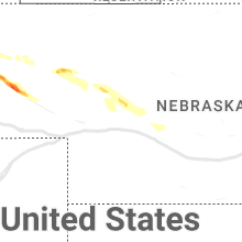


Cities Most Affected by Hail Storms of 7/12/2023
| Hail Size | Demographics of Zip Codes Affected | ||||||
|---|---|---|---|---|---|---|---|
| City | Count | Average | Largest | Pop Density | House Value | Income | Age |
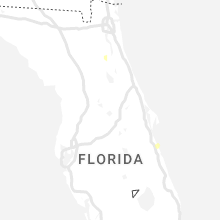
| Minatare, NE | 2 | 1.88 | 2.00 | 9 | $46k | $31.0k | 41.7 |
| Bridgeport, NE | 1 | 1.75 | 1.75 | 2 | $50k | $30.3k | 42.9 |
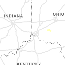
| Amsterdam, MO | 1 | 1.75 | 1.75 | 13 | $45k | $30.7k | 42.4 |
Hail and Wind Damage Spotted on 7/12/2023
Filter by Report Type:Hail ReportsWind Reports
States Impacted
Iowa, Nebraska, Missouri, Louisiana, Maine, New York, Pennsylvania, Florida, Texas, Illinois, Mississippi, Kansas, Michigan, ArkansasIowa
| Local Time | Report Details |
|---|---|
| 7:00 AM CDT | Delayed report - peak wind at personal weather statio in adams county IA, 53.8 miles E of Omaha, NE |
| 7:12 AM CDT | Storm damage reported in adams county IA, 65.4 miles ESE of Omaha, NE |
| 7:15 AM CDT | Trees blown down at the golf cours in montgomery county IA, 54.8 miles ESE of Omaha, NE |
| 7:17 AM CDT | Storm damage reported in adair county IA, 52.7 miles WSW of Des Moines, IA |
| 7:20 AM CDT | Tree limbs down. delayed repor in union county IA, 58 miles SW of Des Moines, IA |
| 7:25 AM CDT | Tree limbs down. delayed repor in union county IA, 53.3 miles SW of Des Moines, IA |
| 7:46 AM CDT | Medium sized tree blown down and blocking the road. delayed report. time estimated from rada in boone county IA, 31.8 miles NNW of Des Moines, IA |
| 7:50 AM CDT | Tree snapped. report from social medi in union county IA, 53.3 miles SW of Des Moines, IA |
| 8:40 AM CDT | Tree branches down over 2 inches diameter. time estimated from rada in johnson county IA, 20.1 miles S of Cedar Rapids, IA |
| 8:45 AM CDT | Branches reported blown down in locations across johnson county. chainsaw use not required by emergency management. time estimated by rada in johnson county IA, 21.8 miles SSE of Cedar Rapids, IA |
| 8:50 AM CDT | Tree branches down over 2 inches diameter. time estimated from rada in johnson county IA, 15.4 miles SE of Cedar Rapids, IA |
| 8:56 AM CDT | Tree branches down over 2 inches diameter. time estimated from rada in johnson county IA, 29.7 miles SSE of Cedar Rapids, IA |
| 9:17 AM CDT | Tree branches down over 2 inches diameter. time estimated from rada in johnson county IA, 35.9 miles SSE of Cedar Rapids, IA |
Nebraska
| Local Time | Report Details |
|---|---|
| 7:15 AM CDT | Corrects previous tstm wnd gst report from burchar in pawnee county NE, 67.9 miles N of Manhattan, KS |
| 7:31 AM CDT | Storm damage reported in pawnee county NE, 67.9 miles N of Manhattan, KS |
| 6:44 PM MDT | Golf Ball sized hail reported near Minatare, NE, 10.9 miles ENE of Scottsbluff, NE |
| 6:47 PM MDT | Hen Egg sized hail reported near Minatare, NE, 12 miles ENE of Scottsbluff, NE, lasted around 5 minutes. |
| 7:15 PM MDT | Ping Pong Ball sized hail reported near Bridgeport, NE, 30.3 miles ESE of Scottsbluff, NE, twitter report of 1.5 inch hail. |
| 7:23 PM MDT | Golf Ball sized hail reported near Bridgeport, NE, 28.6 miles E of Scottsbluff, NE |
Missouri
| Local Time | Report Details |
|---|---|
| 8:30 AM CDT | Rockin jh diese in mercer county MO, 74.6 miles S of Des Moines, IA |
| 5:30 PM CDT | Powerlines and trees dow in chariton county MO, 41.4 miles NW of Columbia, MO |
| 6:27 PM CDT | Large tree down just off highway c near county road 400. time estimated by rada in callaway county MO, 30.9 miles SE of Columbia, MO |
| 6:37 PM CDT | Powerlines down at the 5400 block of highway z. time estimated by rada in boone county MO, 9.2 miles ENE of Columbia, MO |
| 6:42 PM CDT | Several reports of trees down in the columbia area according to boone county 911 joint comms center. time estimated by rada in boone county MO, 0.3 miles SE of Columbia, MO |
| 6:42 PM CDT | Tree on a house near ash street and greenwood. powerlines reported down. report courtesy of abc-1 in boone county MO, 1 miles WNW of Columbia, MO |
| 7:02 PM CDT | Callaway county em relayed a report of roof damage to a residence near county road 334 and shelly driv in callaway county MO, 14.9 miles ESE of Columbia, MO |
| 7:14 PM CDT | Quarter sized hail reported near Fulton, MO, 24.1 miles SE of Columbia, MO, small branches also reported down. |
| 7:27 PM CDT | Osage county em stated that trees were reported down across the railroad tracks in bonnots mill along the missouri rive in osage county MO, 32.7 miles SE of Columbia, MO |
| 7:37 PM CDT | Spotter reported a tree down on a car off starboard drive. a tree had also fallen on a residence off dulles court. several other reports of tree damage and powerline do in st. louis county MO, 8.5 miles SW of Saint Louis, MO |
| 8:14 PM CDT | Spotter located just north of i-44 off overland drive estimated winds to be 60-70 mph. tree limbs down estimated to be 2-3 inches in diamete in crawford county MO, 42.3 miles NNE of Salem, MO |
| 8:20 PM CDT | Tree partially over hwy 185 near the high school near meramec state park. time estimated by rada in franklin county MO, 45.7 miles NNE of Salem, MO |
| 8:20 PM CDT | Spotter report a 1 ft diameter tree down on a trail northeast of sulliva in franklin county MO, 51.8 miles NNE of Salem, MO |
| 8:20 PM CDT | Corrected previous location of the report. report was relayed via email with photos including the location to be off springfield road outside sullivan mo. spotter repor in franklin county MO, 46.9 miles NNE of Salem, MO |
| 8:34 PM CDT | Large tree down blocking hwy 89 south of linn mo. also a power pole down east of town. time estimated by rada in osage county MO, 43.5 miles SE of Columbia, MO |
| 8:39 PM CDT | Golf Ball sized hail reported near Amsterdam, MO, 53.4 miles S of Kansas City, MO, reports of golf ball sized hail and and tree damage. |
| 8:53 PM CDT | Storm damage reported in bates county MO, 50.8 miles SSE of Kansas City, MO |
| 8:53 PM CDT | 8 inch tree limb dow in bates county MO, 51.4 miles SSE of Kansas City, MO |
| 8:56 PM CDT | Spotter estimated winds near 60 mph 4 miles north of potos in washington county MO, 48.5 miles ENE of Salem, MO |
| 9:23 PM CDT | Law enforcement they were responding to a report of a person trapped in their home due to a tree than had fallen on the residence. the officer stated that several trees in st. francois county MO, 56.2 miles SSW of Saint Louis, MO |
| 9:25 PM CDT | Roof damage to an apartment buildin in henry county MO, 54.4 miles SE of Kansas City, MO |
| 9:26 PM CDT | Corrects time of previous tstm wnd gst report from desloge. also reported trees down across the cit in st. francois county MO, 55.1 miles SSW of Saint Louis, MO |
| 9:29 PM CDT | Also reported trees down across the cit in st. francois county MO, 55.1 miles SSW of Saint Louis, MO |
| 9:49 PM CDT | Storm damage reported in pettis county MO, 48.1 miles WSW of Columbia, MO |
| 9:49 PM CDT | Awos station kszl whiteman af in johnson county MO, 62.3 miles ESE of Kansas City, MO |
| 9:49 PM CDT | Reports of extensive tree damage south of knob noste in johnson county MO, 61.8 miles ESE of Kansas City, MO |
| 10:00 PM CDT | Storm damage reported in pettis county MO, 62.4 miles WSW of Columbia, MO |
| 10:17 PM CDT | Report from mping: 3-inch tree limbs broken; power poles broke in st. francois county MO, 50.5 miles E of Salem, MO |
| 10:40 PM CDT | Half Dollar sized hail reported near Butler, MO, 58.3 miles SSE of Kansas City, MO, . |
| 12:52 AM CDT | Joplin airport asos reported 64 mph wind gus in jasper county MO, 64.4 miles SE of Chanute, KS |
| 1:52 AM CDT | Trees down and power outage in texas county MO, 47.3 miles SW of Salem, MO |
| 2:30 AM CDT | Tree down across highway 1 in howell county MO, 46.4 miles SSW of Salem, MO |
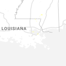
Louisiana
| Local Time | Report Details |
|---|---|
| 1:31 PM CDT | Lake pontchartrain mesonet reported a gust to 71mph wind gus in gmz530 county LA, 17.2 miles N of New Orleans, LA |
Maine
| Local Time | Report Details |
|---|---|
| 4:12 PM EDT | Correction to thunderstorm wind damage. large tree down blocking katahdin iron works road (north woods road) at the 3rd bridge past the checkpoint. time estimated by ra in piscataquis county ME, 51.3 miles NNW of Bangor, ME |
| 4:34 PM EDT | Tree down on powerlines. power is out in the area. time estimated on rada in piscataquis county ME, 41.1 miles NNW of Bangor, ME |
| 5:15 PM EDT | Corrects previous tstm wnd dmg report from 1 nnw brownville junction. tree down on powerlines. power is out in the area. time estimated on rada in piscataquis county ME, 41.1 miles NNW of Bangor, ME |
| 5:17 PM EDT | Tree down on powerlines blocking davis st (route 11). power is out in the area. time estimated based on rada in piscataquis county ME, 40.7 miles NNW of Bangor, ME |
| 5:35 PM EDT | Delayed report: broadcast meteorologists reported a large tree down on allen road. time estimated by rada in cumberland county ME, 3.3 miles NNW of Portland, ME |
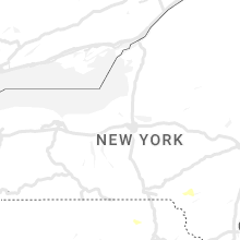
New York
| Local Time | Report Details |
|---|---|
| 4:15 PM EDT | Tree down on wires on chatham st near the fire dep in rensselaer county NY, 26.8 miles SE of Schenectady, NY |
| 5:09 PM EDT | Tree down on st rt 26 in delaware county NY, 50.2 miles NNE of Scranton, PA |
| 5:12 PM EDT | Trees down on fish brook rd. time estimated by rada in delaware county NY, 52.8 miles NNE of Scranton, PA |
Pennsylvania
| Local Time | Report Details |
|---|---|
| 4:19 PM EDT | Multiple trees down via broadcast media social media page. time estimated by rada in susquehanna county PA, 39.5 miles N of Scranton, PA |
| 4:25 PM EDT | Tree down in the road via county dispatch. time estimated by rada in lackawanna county PA, 11 miles N of Scranton, PA |
| 4:37 PM EDT | Trees reported down via county dispatch. time estimated via rada in lackawanna county PA, 14.9 miles NNE of Scranton, PA |
Florida
| Local Time | Report Details |
|---|---|
| 4:20 PM EDT | Ussf wind tower 714 measured a thunderstorm wind gust of 56kts/64mph from the west-southwes in brevard county FL, 38.8 miles E of Orlando, FL |
Texas
| Local Time | Report Details |
|---|---|
| 4:45 PM CDT | Mesonet station fw9692 peco in reeves county TX, 86.1 miles N of Alpine, TX |
| 5:29 PM CDT | West texas mesonet. a few severe-caliber wind gusts were measured between 520 pm and 530 pm cdt... with the highest gust peaking at 72 mp in dickens county TX, 48.6 miles ENE of Lubbock, TX |
Illinois
| Local Time | Report Details |
|---|---|
| 5:27 PM CDT | Six inch tree limb down at fox bend golf course. possible tornado. time estimate in kendall county IL, 38.4 miles WSW of Chicago, IL |
Mississippi
| Local Time | Report Details |
|---|---|
| 6:10 PM CDT | Local law enforcement reported a few trees down near meadow park lane... and mini farm road. one tree fell on a powerline near monore roa in forrest county MS, 82.3 miles SE of Jackson, MS |
| 6:11 PM CDT | Local law enforcement reported multiple trees down across jones count in jones county MS, 83.6 miles SE of Jackson, MS |
| 6:12 PM CDT | Emergency management reported a tree down on a church on chanse ave near carterville r in forrest county MS, 82.9 miles WNW of Mobile, AL |
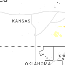
Kansas
| Local Time | Report Details |
|---|---|
| 8:11 PM CDT | Quarter sized hail reported near Mound City, KS, 49.9 miles NE of Chanute, KS |
| 11:30 PM CDT | Twitter report from chase in bourbon county KS, 40.9 miles ENE of Chanute, KS |
| 11:36 PM CDT | Multiple trees and power lines dow in crawford county KS, 45.7 miles E of Chanute, KS |
| 11:40 PM CDT | Trees at least 1ft in diameter down... power poles snappe in crawford county KS, 45.7 miles E of Chanute, KS |
| 12:38 AM CDT | Asos station kcnu chanute martin johnson airpor in neosho county KS, 1.8 miles WSW of Chanute, KS |
| 1:32 AM CDT | Trees down and widespread power outage in crawford county KS, 45.3 miles ESE of Chanute, KS |
Michigan
| Local Time | Report Details |
|---|---|
| 9:25 PM EDT | Greenhouse... chicken coop... and farm stand blown down. tree branches dow in van buren county MI, 46.7 miles SSW of Grand Rapids, MI |
| 10:14 PM EDT | Tree dow in allegan county MI, 29.7 miles S of Grand Rapids, MI |
| 10:14 PM EDT | Tree down. time estimated via rada in allegan county MI, 17.1 miles S of Grand Rapids, MI |
| 10:31 PM EDT | Tree down. time estimated via rada in barry county MI, 22.7 miles SSE of Grand Rapids, MI |
| 10:42 PM EDT | Multiple trees and wires down in hastings/yankee springs areas. time estimated via rada in barry county MI, 29.5 miles SE of Grand Rapids, MI |
| 11:01 PM EDT | Tree down at risk & deitz. time estimated via rada in ionia county MI, 22.2 miles ENE of Grand Rapids, MI |
| 11:13 PM EDT | Spotter reported barn destroyed... powerline flashes visibl in st. joseph county MI, 62 miles N of Fort Wayne, IN |
| 11:14 PM EDT | Tree down. time estimated via rada in ionia county MI, 27.5 miles E of Grand Rapids, MI |
| 12:05 AM EDT | Wind gust at the wlns studi in ingham county MI, 45.8 miles WSW of Flint, MI |
| 12:09 AM EDT | Multiple tree branches and powerlines down across lansing are in ingham county MI, 47.7 miles WSW of Flint, MI |
Arkansas
| Local Time | Report Details |
|---|---|
| 4:50 AM CDT | Northwest arkansas regional airport asos observed gust to 63mp in benton county AR, 62.1 miles N of Fort Smith, AR |
| 5:16 AM CDT | Drake field (kfyv) asos measured 55 kt thunderstorm wind gust in washington county AR, 45.4 miles NNE of Fort Smith, AR |
Connect with Interactive Hail Maps