

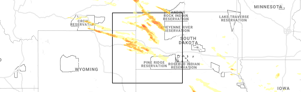
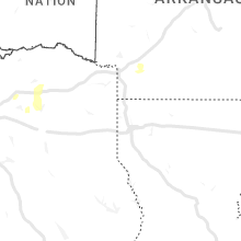
Hail Map for Tuesday, July 11, 2023
Number of Impacted Households on 7/11/2023
0
Impacted by 1" or Larger Hail
0
Impacted by 1.75" or Larger Hail
0
Impacted by 2.5" or Larger Hail
Square Miles of Populated Area Impacted on 7/11/2023
0
Impacted by 1" or Larger Hail
0
Impacted by 1.75" or Larger Hail
0
Impacted by 2.5" or Larger Hail


Cities Most Affected by Hail Storms of 7/11/2023
| Hail Size | Demographics of Zip Codes Affected | ||||||
|---|---|---|---|---|---|---|---|
| City | Count | Average | Largest | Pop Density | House Value | Income | Age |
| Rapid City, SD | 4 | 1.81 | 2.00 | 111 | $119k | $47.4k | 44.3 |
| Hazard, NE | 2 | 2.75 | 2.75 | 5 | $39k | $27.8k | 44.0 |
| Ravenna, NE | 2 | 2.75 | 2.75 | 11 | $53k | $31.4k | 43.3 |
| Wibaux, MT | 1 | 3.00 | 3.00 | 1 | $38k | $28.2k | 49.0 |
| Sheridan, WY | 1 | 2.75 | 2.75 | 36 | $103k | $34.3k | 40.9 |
| Clearmont, WY | 1 | 2.75 | 2.75 | 0 | $65k | $35.2k | 43.8 |
| Decker, MT | 1 | 2.50 | 2.50 | 0 | $47k | $17.8k | 45.0 |
| Recluse, WY | 1 | 2.50 | 2.50 | 0 | $113k | $55.2k | 50.3 |
| Devils Tower, WY | 1 | 2.00 | 2.00 | 1 | $460k | $33.8k | 54.3 |
| Ludlow, SD | 1 | 1.75 | 1.75 | 1 | $29k | $17.5k | 38.0 |
| Rhame, ND | 1 | 1.75 | 1.75 | 0 | $31k | $22.9k | 47.0 |
| Culbertson, MT | 1 | 1.75 | 1.75 | 1 | $48k | $30.4k | 45.0 |
Hail and Wind Damage Spotted on 7/11/2023
Filter by Report Type:Hail ReportsWind Reports
States Impacted
Nebraska, Michigan, Illinois, Mississippi, Montana, South Dakota, Wyoming, North Dakota, Texas, IowaNebraska
| Local Time | Report Details |
|---|---|
| 11:55 AM CDT | Baseball sized hail reported near Hazard, NE, 37.8 miles WNW of Grand Island, NE, tennis to baseball size hail reported from storm chaser... windshield broken. |
| 10:24 PM CDT | Half Dollar sized hail reported near Broken Bow, NE, 65.5 miles ENE of North Platte, NE, report relayed from emergency manager. |
| 11:02 PM CDT | Ping Pong Ball sized hail reported near Ansley, NE, 66.9 miles WNW of Grand Island, NE |
| 11:28 PM CDT | Quarter sized hail reported near Mason City, NE, 51.2 miles WNW of Grand Island, NE, em relayed report of quarter sized hail. |
| 11:30 PM CDT | Ping Pong Ball sized hail reported near Litchfield, NE, 47.8 miles WNW of Grand Island, NE |
| 11:55 PM CDT | Baseball sized hail reported near Hazard, NE, 37.8 miles WNW of Grand Island, NE, tennis to baseball size hail reported from storm chaser... windshield broken. corrected time from 1155 am to 1155 pm. |
| 12:04 AM CDT | Baseball sized hail reported near Ravenna, NE, 32.2 miles WNW of Grand Island, NE, report from spotter network of hail to baseball size... windshield broken. |
| 12:05 AM CDT | Baseball sized hail reported near Ravenna, NE, 32.6 miles WNW of Grand Island, NE, mainly golf ball sized hail but a few were as big as baseballs. |
| 2:16 AM CDT | Asos reports 60 mph gus in cherry county NE, 1 miles S of Valentine, NE |
| 2:19 AM CDT | Asos reports 71 mph wind gus in cherry county NE, 1 miles S of Valentine, NE |
| 2:28 AM CDT | Asos reports another gust of 71 mph with 0.75 mmi visibilit in cherry county NE, 1 miles S of Valentine, NE |
| 2:55 AM CDT | Storm damage reported in brown county NE, 34.6 miles SE of Valentine, NE |
| 3:23 AM CDT | Storm damage reported in holt county NE, 31.9 miles NNW of Oneill, NE |
| 3:27 AM CDT | Storm damage reported in holt county NE, 27.2 miles WNW of Oneill, NE |
| 3:32 AM CDT | Pws reports via weather undergroun in holt county NE, 32.1 miles NW of Oneill, NE |
| 3:43 AM CDT | Pws reports via ambient weathe in holt county NE, 8.8 miles WNW of Oneill, NE |
| 3:55 AM CDT | Konl awo in holt county NE, 1.8 miles WNW of Oneill, NE |
| 4:15 AM CDT | Measured from personal weather statio in knox county NE, 38.3 miles E of Oneill, NE |
| 4:38 AM CDT | Pws via ambient weather report in wheeler county NE, 43.9 miles S of Oneill, NE |
| 4:43 AM CDT | Kbrx radio station in oneill reports some tree limbs down and minor street flooding in oneil in holt county NE, 0.2 miles NNW of Oneill, NE |
| 4:51 AM CDT | Measured at kofk aso in madison county NE, 70.4 miles ESE of Oneill, NE |
| 5:08 AM CDT | Personal weather statio in cuming county NE, 71.9 miles NW of Omaha, NE |
| 5:08 AM CDT | Recorded at a personal weather statio in cuming county NE, 71.1 miles NW of Omaha, NE |
| 5:10 AM CDT | As recorded at a personal weather statio in wayne county NE, 79.7 miles NW of Omaha, NE |
| 5:14 AM CDT | Via personal weather statio in union county SD, 69.3 miles W of Storm Lake, IA |
| 5:14 AM CDT | Tree roughly 30 feet tall and 12 inch in diameter blocking westbound lane of hwy 20 in jackso in dakota county NE, 71.2 miles W of Storm Lake, IA |
| 5:16 AM CDT | Storm damage reported in colfax county NE, 63.8 miles WNW of Omaha, NE |
| 5:20 AM CDT | Updates previous tstm wnd dmg report from bancroft. widespread tree damage in and near bancroft. power poles snapped off. roof blown off of a machine she in cuming county NE, 61.1 miles NNW of Omaha, NE |
| 5:29 AM CDT | As measured by a personal weather statio in burt county NE, 48.5 miles NW of Omaha, NE |
| 5:31 AM CDT | Personal weather statio in stanton county NE, 77.7 miles NW of Omaha, NE |
| 5:36 AM CDT | Measured by an anemomete in dodge county NE, 41 miles NW of Omaha, NE |
| 5:50 AM CDT | At fremont airpor in dodge county NE, 32.8 miles WNW of Omaha, NE |
| 5:59 AM CDT | Personal weather statio in douglas county NE, 13.7 miles WNW of Omaha, NE |
| 5:59 AM CDT | At nws omah in douglas county NE, 22.7 miles W of Omaha, NE |
| 6:09 AM CDT | Personal weather statio in douglas county NE, 7.7 miles NNW of Omaha, NE |
| 6:10 AM CDT | Widespread tree damage reported in tow in washington county NE, 14.5 miles NNW of Omaha, NE |
| 6:11 AM CDT | Large tree down... time estimated from rada in saunders county NE, 23.9 miles W of Omaha, NE |
| 6:16 AM CDT | Recorded at eppley airpor in douglas county NE, 3.4 miles NE of Omaha, NE |
| 6:19 AM CDT | Storm damage reported in douglas county NE, 5.5 miles NW of Omaha, NE |
| 6:23 AM CDT | Storm damage reported in sarpy county NE, 23.2 miles SW of Omaha, NE |
| 6:27 AM CDT | Personal weather statio in sarpy county NE, 9.7 miles S of Omaha, NE |
| 11:27 AM UTC | Reported by klnk airport aso in lancaster county NE, 51.3 miles WSW of Omaha, NE |
| 6:27 AM CDT | Powerlines down and sparkin in sarpy county NE, 10.4 miles SW of Omaha, NE |
| 6:32 AM CDT | Medium tree snapped at trun in douglas county NE, 0.1 miles SSE of Omaha, NE |
| 6:34 AM CDT | Tree down on house... no injurie in stanton county NE, 81.3 miles ESE of Oneill, NE |
| 6:34 AM CDT | Personal weather statio in cass county NE, 36.7 miles SSW of Omaha, NE |
| 6:39 AM CDT | Trees down across hwy 6 in cass county NE, 19.2 miles SSW of Omaha, NE |
| 6:40 AM CDT | Personal weather statio in lancaster county NE, 59.8 miles SW of Omaha, NE |
Michigan
| Local Time | Report Details |
|---|---|
| 2:52 PM EDT | Quarter sized hail reported near Mayville, MI, 28.2 miles NNE of Flint, MI, picture of quarter sized hail |
| 3:13 PM EDT | Dispatch reports wires down across the northern portion of lapeer county with a tree down near mayville in lapeer county MI, 28.4 miles NE of Flint, MI |
| 4:02 PM EDT | Tree and large limbs down with small hail in livingston county MI, 42.8 miles SSW of Flint, MI |
| 4:02 PM EDT | Em reports numerous trees down on houses... numerous wires down... and a 20ft pontoon boat was flipped on halfmoon lake in washtenaw county MI, 44 miles SSW of Flint, MI |
| 4:42 PM EDT | Social media picture of tree across road near the intersection of silverbell and gallagher rds in oakland county MI, 33 miles SE of Flint, MI |
| 4:43 PM EDT | Large limbs down area the area of rochester rd... hamlin rd... and avon rds in oakland county MI, 37.7 miles SE of Flint, MI |
| 4:44 PM EDT | Large limbs down causing damage to house siding near avon and dequindre in oakland county MI, 37.9 miles SE of Flint, MI |
| 4:49 PM EDT | Numerous large limbs down around 24 mile and shelby rd in macomb county MI, 38.7 miles SE of Flint, MI |
| 5:00 PM EDT | Em reports numerous trees down and damage to a barn near clinton and allen rds in washtenaw county MI, 65.2 miles SSW of Flint, MI |
| 5:03 PM EDT | Large tree limbs down partially blocking north ave between 26 and 27 mile rds in macomb county MI, 45.3 miles ESE of Flint, MI |
| 5:05 PM EDT | Social media pictures of numerous trees down in yards... across streets... and on power lines in macomb county MI, 49.3 miles ESE of Flint, MI |
| 5:12 PM EDT | Social media pictures of large limbs down near m-29 and walpol in macomb county MI, 53.8 miles ESE of Flint, MI |
| 5:20 PM EDT | Pictures of tree uprooted... numerous tree limbs of various sizes down in lenawee county MI, 68.8 miles S of Flint, MI |
| 5:25 PM EDT | Quarter sized hail reported near Britton, MI, 70 miles S of Flint, MI, quarter size hail along the edge of the hail core |
| 5:30 PM EDT | Tree limbs down throughout town in st. clair county MI, 63.7 miles ESE of Flint, MI |
| 5:48 PM EDT | Large limbs down in yard near mayer and yager rds in st. clair county MI, 54.6 miles E of Flint, MI |
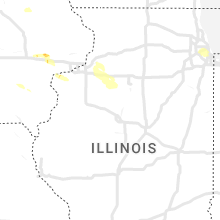
Illinois
| Local Time | Report Details |
|---|---|
| 2:33 PM CDT | Storm damage reported in cook county IL, 9.7 miles SW of Chicago, IL |
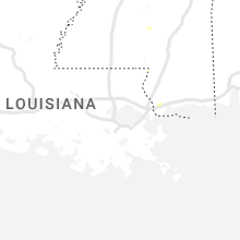
Mississippi
| Local Time | Report Details |
|---|---|
| 3:09 PM CDT | Trees were reported down along hwy 2 in copiah county MS, 42.7 miles SSW of Jackson, MS |
Montana
| Local Time | Report Details |
|---|---|
| 2:38 PM MDT | Quarter sized hail reported near Brockton, MT, 63.5 miles WNW of Williston, ND, also reported 30-40mph gusts. |
| 3:15 PM MDT | Golf Ball sized hail reported near Culbertson, MT, 41.1 miles W of Williston, ND, picture of hailstone submitted via facebook. |
| 3:20 PM MDT | Quarter sized hail reported near Culbertson, MT, 41.5 miles W of Williston, ND, also noted that hail was accumulating in town (at least one inch deep). |
| 3:23 PM MDT | Ping Pong Ball sized hail reported near Culbertson, MT, 41.5 miles W of Williston, ND, facebook photos showed hail measuring up to ping pong ball size and accumulating on the roadways. |
| 4:07 PM MDT | Quarter sized hail reported near Glendive, MT, 60.2 miles NE of Miles City, MT, via facebook. |
| 4:14 PM MDT | Ping Pong Ball sized hail reported near Lindsay, MT, 65.2 miles NNE of Miles City, MT, ping pong ball size estimated with photo. |
| 4:17 PM MDT | 3-4 inch diameter trees limbs dow in custer county MT, 0.5 miles S of Miles City, MT |
| 4:17 PM MDT | 3-4 inch diameter trees limbs dow in custer county MT, 0.5 miles S of Miles City, MT |
| 4:25 PM MDT | Quarter sized hail reported near Circle, MT, 64.1 miles SSE of Glasgow, MT, spotter reported heavy locally heavy rainfall with 1 inch hail stones bouncing off the ground. |
| 4:40 PM MDT | Quarter sized hail reported near Circle, MT, 71 miles N of Miles City, MT |
| 4:47 PM MDT | Quarter sized hail reported near Glendive, MT, 62.4 miles NE of Miles City, MT |
| 4:51 PM MDT | Large cottonwood tree down in custer county MT, 2.3 miles SE of Miles City, MT |
| 4:52 PM MDT | Quarter sized hail reported near Glendive, MT, 57 miles NE of Miles City, MT |
| 5:24 PM MDT | Reported at the pine hills raws sit in wibaux county MT, 65.7 miles ENE of Miles City, MT |
| 5:31 PM MDT | Tea Cup sized hail reported near Wibaux, MT, 74.6 miles ENE of Miles City, MT, spotter reported a hail stone of 3 inches embedded within a field of 1 inch sized hail. |
| 5:57 PM MDT | Quarter sized hail reported near Baker, MT, 78.4 miles E of Miles City, MT |
| 5:59 PM MDT | Ping Pong Ball sized hail reported near Baker, MT, 85.3 miles E of Miles City, MT |
| 6:05 PM MDT | Cannonball creek raws in fallon county MT, 85.1 miles E of Miles City, MT |
| 6:10 PM MDT | Tennis Ball sized hail reported near Decker, MT, 82 miles NW of Gillette, WY, picture from social media |
| 8:00 PM MDT | Quarter sized hail reported near Miles City, MT, 7.9 miles SSE of Miles City, MT |
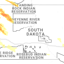
South Dakota
| Local Time | Report Details |
|---|---|
| 4:56 PM MDT | Ping Pong Ball sized hail reported near Box Elder, SD, 8.4 miles ENE of Rapid City, SD |
| 5:48 PM MDT | Quarter sized hail reported near Rapid City, SD, 9.6 miles WNW of Rapid City, SD |
| 6:11 PM MDT | Half Dollar sized hail reported near Rapid City, SD, 4.2 miles S of Rapid City, SD |
| 6:14 PM MDT | Half Dollar sized hail reported near Newell, SD, 70.8 miles N of Rapid City, SD |
| 6:19 PM MDT | Quarter sized hail reported near Rapid City, SD, 4.2 miles S of Rapid City, SD |
| 6:21 PM MDT | Storm damage reported in butte county SD, 68.8 miles N of Rapid City, SD |
| 6:48 PM MDT | Quarter sized hail reported near Newell, SD, 55.2 miles N of Rapid City, SD |
| 7:15 PM MDT | Ping Pong Ball sized hail reported near Lemmon, SD, 82.7 miles SW of Bismarck, ND, hail lasted about 15 minutes 815 to 830 pm. |
| 7:40 PM MDT | Quarter sized hail reported near Ludlow, SD, 122.5 miles ESE of Miles City, MT, marbles with a few quarter hail |
| 7:56 PM MDT | Storm damage reported in harding county SD, 124 miles ESE of Miles City, MT |
| 7:59 PM MDT | Ping Pong Ball sized hail reported near New Underwood, SD, 34.3 miles NE of Rapid City, SD |
| 8:18 PM MDT | Ping Pong Ball sized hail reported near Prairie City, SD, 110.2 miles N of Rapid City, SD |
| 9:14 PM MDT | Quarter sized hail reported near Spearfish, SD, 42.1 miles NW of Rapid City, SD, mping report |
| 9:33 PM MDT | Golf Ball sized hail reported near Ludlow, SD, 119.6 miles N of Rapid City, SD |
| 10:00 PM MDT | Golf Ball sized hail reported near Rapid City, SD, 13.4 miles W of Rapid City, SD |
| 10:10 PM MDT | Quarter sized hail reported near Rapid City, SD, 8.7 miles WSW of Rapid City, SD |
| 10:19 PM MDT | Golf Ball sized hail reported near Rapid City, SD, 5.1 miles SW of Rapid City, SD, mping report |
| 10:20 PM MDT | Quarter sized hail reported near Rapid City, SD, 3.3 miles SW of Rapid City, SD, mping report |
| 10:20 PM MDT | Ping Pong Ball sized hail reported near Rapid City, SD, 5.1 miles SW of Rapid City, SD |
| 10:22 PM MDT | Quarter sized hail reported near Rapid City, SD, 1.5 miles S of Rapid City, SD |
| 10:23 PM MDT | Hen Egg sized hail reported near Rapid City, SD, 4.2 miles S of Rapid City, SD |
| 10:24 PM MDT | Ping Pong Ball sized hail reported near Rapid City, SD, 4 miles SSW of Rapid City, SD, mping report |
| 10:25 PM MDT | Golf Ball sized hail reported near Rapid City, SD, 3.8 miles SSW of Rapid City, SD |
| 10:25 PM MDT | Ping Pong Ball sized hail reported near Rapid City, SD, 3.6 miles SW of Rapid City, SD |
| 2:07 AM CDT | Storm damage reported in todd county SD, 15.8 miles N of Valentine, NE |
| 2:12 AM CDT | Storm damage reported in todd county SD, 15.8 miles N of Valentine, NE |
| 2:36 AM CDT | Mesonet station 214 sd rwis plankinto in aurora county SD, 86.5 miles N of Oneill, NE |
| 2:37 AM CDT | Storm damage reported in tripp county SD, 40.2 miles ENE of Valentine, NE |
| 2:42 AM CDT | Storm damage reported in tripp county SD, 40.2 miles ENE of Valentine, NE |
| 2:52 AM CDT | Storm damage reported in tripp county SD, 40.2 miles ENE of Valentine, NE |
| 2:57 AM CDT | Storm damage reported in tripp county SD, 40.2 miles ENE of Valentine, NE |
| 3:02 AM CDT | Quarter sized hail reported near Mitchell, SD, 65.6 miles W of Sioux Falls, SD, report from mping: quarter (1.00 in.). |
| 3:07 AM CDT | Storm damage reported in tripp county SD, 40.2 miles ENE of Valentine, NE |
| 3:12 AM CDT | Storm damage reported in tripp county SD, 40.2 miles ENE of Valentine, NE |
| 3:20 AM CDT | Mesonet station 213 sd rwis alexandri in hanson county SD, 49.8 miles W of Sioux Falls, SD |
| 3:28 AM CDT | Mesonet station 244 sd rwis ft. randall da in gregory county SD, 41.1 miles N of Oneill, NE |
| 3:36 AM CDT | Mesonet station 26 sd rwis trip in hutchinson county SD, 63.5 miles NNE of Oneill, NE |
| 3:43 AM CDT | Ping Pong Ball sized hail reported near Volin, SD, 44.7 miles SSW of Sioux Falls, SD, pictures via social media. |
| 3:50 AM CDT | Mesonet station 18 sd rwis montros in mccook county SD, 22.7 miles WNW of Sioux Falls, SD |
| 3:51 AM CDT | Mesonet station 163 sd rwis freema in hutchinson county SD, 39.2 miles WSW of Sioux Falls, SD |
| 3:58 AM CDT | Mesonet station 179 sd rwis tyndal in bon homme county SD, 57 miles NE of Oneill, NE |
| 4:01 AM CDT | Mesonet station 310 sd rwis parke in turner county SD, 21.3 miles SW of Sioux Falls, SD |
| 4:13 AM CDT | Awos station kykn yankton municipal airpor in yankton county SD, 53.9 miles SW of Sioux Falls, SD |
| 4:13 AM CDT | Asos station kfsd sioux falls airpor in minnehaha county SD, 2.6 miles NNW of Sioux Falls, SD |
| 4:17 AM CDT | Mesonet station 197 sd rwis gayvill in yankton county SD, 52.1 miles SSW of Sioux Falls, SD |
| 4:26 AM CDT | Mesonet station bfms2 beresford 7 wsw (sd mesonet in clay county SD, 35.9 miles SSW of Sioux Falls, SD |
| 4:30 AM CDT | Mesonet station 16 sd rwis beresfor in union county SD, 35.1 miles S of Sioux Falls, SD |
| 4:39 AM CDT | Via personal weather statio in union county SD, 53 miles S of Sioux Falls, SD |
Wyoming
| Local Time | Report Details |
|---|---|
| 5:38 PM MDT | Baseball sized hail reported near Sheridan, WY, 81.5 miles NW of Gillette, WY |
| 6:00 PM MDT | Ping Pong Ball sized hail reported near Sheridan, WY, 72.7 miles NW of Gillette, WY, windows broken by hail. |
| 6:24 PM MDT | Baseball sized hail reported near Clearmont, WY, 54.6 miles NW of Gillette, WY |
| 6:40 PM MDT | Ping Pong Ball sized hail reported near Sheridan, WY, 72.7 miles NW of Gillette, WY |
| 7:08 PM MDT | Tennis Ball sized hail reported near Recluse, WY, 33 miles NNW of Gillette, WY, broken windows and damaged siding. likely more damage than that. also estimated 50-60+ mph winds. |
| 7:08 PM MDT | Broken windows and damaged siding. likely more damage than that. estimated 50-60+ mph winds with tennis ball size hai in campbell county WY, 33 miles NNW of Gillette, WY |
| 7:59 PM MDT | Quarter sized hail reported near Moorcroft, WY, 34.4 miles NE of Gillette, WY |
| 8:15 PM MDT | Storm damage reported in crook county WY, 44.3 miles ENE of Gillette, WY |
| 8:15 PM MDT | Hen Egg sized hail reported near Devils Tower, WY, 44.3 miles ENE of Gillette, WY |
| 8:27 PM MDT | Ping Pong Ball sized hail reported near Sundance, WY, 44.3 miles ENE of Gillette, WY |
| 8:41 PM MDT | Half Dollar sized hail reported near Sundance, WY, 56.2 miles E of Gillette, WY |
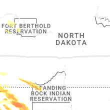
North Dakota
| Local Time | Report Details |
|---|---|
| 6:26 PM MDT | Ndawn mesonet site measured at 10 meter in slope county ND, 92.4 miles E of Miles City, MT |
| 6:37 PM MDT | Golf Ball sized hail reported near Rhame, ND, 100.3 miles E of Miles City, MT, ongoing at time of observation. moving north to south. |
| 6:47 PM MDT | Quarter sized hail reported near Rhame, ND, 105.5 miles E of Miles City, MT, report from social media... 6 minute duration. |
| 8:06 PM MDT | Storm damage reported in harding county SD, 123.4 miles N of Rapid City, SD |
Texas
| Local Time | Report Details |
|---|---|
| 4:23 AM CDT | West texas mesonet 1nw of palo duro reservoi in hansford county TX, 87.6 miles NNE of Amarillo, TX |
| 5:40 AM CDT | Mesa vista awos measured 58 mph wind gust from heat burst due to nearby thunderstor in roberts county TX, 65.3 miles NE of Amarillo, TX |
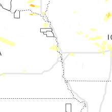
Iowa
| Local Time | Report Details |
|---|---|
| 4:58 AM CDT | Tree branch and powerline down over division st between 3rd and 5th s in sioux county IA, 38.6 miles SE of Sioux Falls, SD |
| 5:24 AM CDT | Wires down across the west side of sioux cit in woodbury county IA, 64.5 miles W of Storm Lake, IA |
| 5:26 AM CDT | Asos station ksux sioux gateway airpor in woodbury county IA, 63 miles WSW of Storm Lake, IA |
| 5:35 AM CDT | Storm damage reported in woodbury county IA, 59.5 miles WSW of Storm Lake, IA |
| 11:28 AM UTC | Mesonet station rsli4 storm lak in buena vista county IA, 7.5 miles NNE of Storm Lake, IA |
Connect with Interactive Hail Maps