

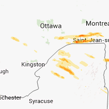
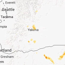
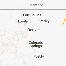
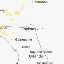
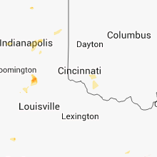
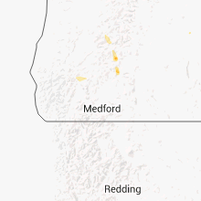
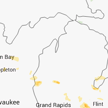
Hail Map for Tuesday, July 17, 2012

Number of Impacted Households on 7/17/2012
0
Impacted by 1" or Larger Hail
0
Impacted by 1.75" or Larger Hail
0
Impacted by 2.5" or Larger Hail
Square Miles of Populated Area Impacted on 7/17/2012
0
Impacted by 1" or Larger Hail
0
Impacted by 1.75" or Larger Hail
0
Impacted by 2.5" or Larger Hail


Cities Most Affected by Hail Storms of 7/17/2012
| Hail Size | Demographics of Zip Codes Affected | ||||||
|---|---|---|---|---|---|---|---|
| City | Count | Average | Largest | Pop Density | House Value | Income | Age |
| Cottonwood, ID | 1 | 1.75 | 1.75 | 2 | $84k | $33.1k | 38.9 |
Hail and Wind Damage Spotted on 7/17/2012
Filter by Report Type:Hail ReportsWind Reports
States Impacted
Georgia, South Carolina, North Carolina, Florida, Tennessee, New York, South Dakota, Alabama, Texas, Wisconsin, Vermont, Nebraska, Indiana, Wyoming, New Hampshire, Colorado, Oregon, Michigan, Montana, Idaho, MissouriGeorgia
| Local Time | Report Details |
|---|---|
| 12:15 PM EDT | Quarter sized hail reported near Sylvester, GA, 55.3 miles W of Douglas, GA, law enforcement reports quarter inch hail |
| 12:30 PM EDT | Tree down on highway 107 one mile into irwin count in irwin county GA, 29.7 miles WNW of Douglas, GA |
| 12:55 PM EDT | Trees down along hwy 112 near ashburn in turner county GA, 47.2 miles WNW of Douglas, GA |
| 1:00 PM EDT | Quarter sized hail reported near Camilla, GA, 54.6 miles N of Tallahassee, FL, quarter size hail reported in camilla. |
| 1:15 PM EDT | Quarter sized hail reported near Camilla, GA, 54.6 miles N of Tallahassee, FL, quarter size hail in camilla. |
| 1:15 PM EDT | Power lines and trees dow in tift county GA, 39.2 miles W of Douglas, GA |
| 1:18 PM EDT | One tree down on power in berrien county GA, 28.3 miles SSW of Douglas, GA |
| 1:35 PM EDT | Several trees and power lines blown down in the winder are in barrow county GA, 42 miles ENE of Atlanta, GA |
| 1:42 PM EDT | Several trees down countywide in berrien county GA, 29.1 miles WSW of Douglas, GA |
| 1:45 PM EDT | The sheriffs office reported a large tree down on old graham road which was blocking the roadway. the time given was based on rada in jeff davis county GA, 29.1 miles NNE of Douglas, GA |
| 2:15 PM EDT | Several trees blown down in the walnut grove are in walton county GA, 31.2 miles E of Atlanta, GA |
| 2:20 PM EDT | Several trees blown down in the oxford are in newton county GA, 31.3 miles ESE of Atlanta, GA |
| 2:25 PM EDT | Trees down near the town center of ambrose in coffee county GA, 11.1 miles WNW of Douglas, GA |
| 2:30 PM EDT | One large tree down on 4th ave se in cairo by southside eleme in grady county GA, 30.6 miles N of Tallahassee, FL |
| 2:30 PM EDT | Several large trees in grady county GA, 30.6 miles N of Tallahassee, FL |
| 2:30 PM EDT | Large trees down on 2 homes on birmingham avenue in nicholls. in addition...quarter sized hail was reporte in coffee county GA, 12.4 miles E of Douglas, GA |
| 2:34 PM EDT | Tree down on home at 891 bold springs roa in grady county GA, 30.6 miles N of Tallahassee, FL |
| 2:34 PM EDT | County dispatch reports trees down in parts of grady count in grady county GA, 28.3 miles N of Tallahassee, FL |
| 2:53 PM EDT | County dispatch reports numerous trees down all over decatur count in decatur county GA, 36.4 miles NNW of Tallahassee, FL |
| 3:20 PM EDT | Numerous trees down. some over roadway in decatur county GA, 38.5 miles WNW of Tallahassee, FL |
| 3:20 PM EDT | Public reported one large tree down across a driveway on northeast side of mcdonoug in henry county GA, 24.7 miles SE of Atlanta, GA |
| 3:25 PM EDT | Powerlines down in city of boston in thomas county GA, 37.4 miles NE of Tallahassee, FL |
| 4:40 PM EDT | A couple of trees were blown down in the gay are in meriwether county GA, 46.5 miles SSW of Atlanta, GA |
| 5:32 PM EDT | Harris county ema relayed a report of 30 trees down west of pine mountain. time is based on rada in harris county GA, 38 miles ENE of Auburn, AL |
| 5:45 PM EDT | Quarter sized hail reported near Pine Mountain, GA, 41 miles ENE of Auburn, AL |
| 5:58 PM EDT | A couple of trees were blown down in the centralhatchee are in heard county GA, 48.5 miles WSW of Atlanta, GA |
| 11:12 PM EDT | The sheriffs office reported a large tree down on old graham road which was blocking the roadway. the time given was based on rada in jeff davis county GA, 29.1 miles NNE of Douglas, GA |
South Carolina
| Local Time | Report Details |
|---|---|
| 1:22 PM EDT | Dispatch center reported a tree down at sc hwy 3 and cohens bluff r in allendale county SC, 54.3 miles SE of Augusta, GA |
| 2:55 PM EDT | Tree down on highway 21 near scdot shed according to highway patro in colleton county SC, 47.8 miles WSW of Charleston, SC |
| 3:00 PM EDT | Dispatch center reported a tree down on hwy 21 at risher r in colleton county SC, 47.8 miles WSW of Charleston, SC |
| 3:05 PM EDT | Dispatch center reported trees down on highway 21 at quarters driv in colleton county SC, 48.7 miles WSW of Charleston, SC |
| 3:20 PM EDT | Dispatch center reported a car hit a tree that fell on jefferies blvd in walterbor in colleton county SC, 43 miles WSW of Charleston, SC |
| 4:04 PM EDT | Dispatch center reported trees down on highway 21 at quarters driv in colleton county SC, 48.7 miles WSW of Charleston, SC |
| 4:48 PM EDT | Dispatch center reported a tree down at intersection of highway 462 and glover rd. pea size hail also reporte in jasper county SC, 26.5 miles NNE of Savannah, GA |
| 5:20 PM EDT | Dispatch center reported a tree on a car on mungin creek rd. no injurie in jasper county SC, 10.2 miles NNE of Savannah, GA |
| 5:40 PM EDT | A few large tree limbs down at musgrove mill state historic sit in laurens county SC, 45.8 miles ESE of Greenville, SC |
| 7:20 PM EDT | Quarter sized hail reported near Spartanburg, SC, 38.8 miles ENE of Greenville, SC |
North Carolina
| Local Time | Report Details |
|---|---|
| 2:24 PM EDT | Multiple trees and power lines down on 4th ave west near north washington s in henderson county NC, 34.6 miles NNE of Greenville, SC |
| 4:51 PM EDT | A few trees down along wolf pond road in union county NC, 24.2 miles SE of Charlotte, NC |
Florida
| Local Time | Report Details |
|---|---|
| 1:34 PM CDT | Tree down on home at 891 bold springs roa in bay county FL, 52.9 miles E of Miramar Beach, FL |
| 1:41 PM CDT | Power line down at 800 n 15th in mexico beac in bay county FL, 63.5 miles ESE of Miramar Beach, FL |
| 3:15 PM EDT | Tree down on power line on county road 25 in jefferson county FL, 19.8 miles E of Tallahassee, FL |
| 2:20 PM CDT | Trees down between argyle and ponce de leon on u.s. 9 in holmes county FL, 34.6 miles NE of Miramar Beach, FL |
| 3:30 PM EDT | Tree down on power line on cherry tree road close to highway 2 in jefferson county FL, 19.8 miles E of Tallahassee, FL |
| 3:39 PM EDT | Trees down near mile marker 161 on interstate 10 in gadsden county FL, 38.6 miles WNW of Tallahassee, FL |
| 2:40 PM CDT | Trees down at college poin in bay county FL, 45.1 miles E of Miramar Beach, FL |
| 3:40 PM EDT | St lucie em reported one quarter of plywood roof peeled off of a quadplex. possible tornado. time estimated by rada in st. lucie county FL, 17 miles N of Port Saint Lucie, FL |
| 3:53 PM EDT | Roof damage at piney in leon county FL, 4.2 miles E of Tallahassee, FL |
| 3:54 PM EDT | Tree on house at 5504 hampton oak plac in leon county FL, 6 miles E of Tallahassee, FL |
| 3:57 PM EDT | Tree down over roadway in gadsden county FL, 34.4 miles WNW of Tallahassee, FL |
| 3:58 PM EDT | Tree down on power line at bucklake road at pedrick roa in leon county FL, 6.2 miles ENE of Tallahassee, FL |
| 3:58 PM EDT | A car crashed into a tree on bucklake road at chaires roa in leon county FL, 9.7 miles E of Tallahassee, FL |
| 4:00 PM EDT | The sheriffs received reports of a tree down just east of dowling park and another just north of luraville. the trees were partially blocking the roadways. the time giv in suwannee county FL, 63.7 miles ESE of Tallahassee, FL |
| 4:02 PM EDT | Tree down on springhill road one mile south of orange avenu in leon county FL, 3.1 miles SW of Tallahassee, FL |
| 3:03 PM CDT | Tree down on power line on e 9th c in bay county FL, 43.4 miles ESE of Miramar Beach, FL |
| 4:13 PM EDT | Trees and limbs on powerlines at old st. augustine road at southwood plantation roa in leon county FL, 4.4 miles ESE of Tallahassee, FL |
| 4:14 PM EDT | Tree on road at march road at apalachee parkwa in leon county FL, 5.4 miles E of Tallahassee, FL |
| 4:19 PM EDT | Tree/limbs down on power line at ro co co road and veterans memorial driv in leon county FL, 16.6 miles ENE of Tallahassee, FL |
| 3:20 PM CDT | Trees down between argyle and ponce de leon on u.s. 9 in holmes county FL, 34.6 miles NE of Miramar Beach, FL |
| 4:20 PM EDT | The ema reported trees and powerlines as well damage to a corn field due to a possible microburst. the time given was based on rada in suwannee county FL, 74.9 miles ESE of Tallahassee, FL |
| 4:27 PM EDT | Tree/limbs on power lines at jefferson road at mahan driv in leon county FL, 13.7 miles ENE of Tallahassee, FL |
| 4:27 PM EDT | Tree on roadway at stone road at old bainbridge roa in leon county FL, 3.3 miles NNW of Tallahassee, FL |
| 4:28 PM EDT | Trees down on rivers road and lafrance in leon county FL, 6 miles SSW of Tallahassee, FL |
| 3:29 PM CDT | Trees and powerline down at burnt mill creek road and state highway 38 in bay county FL, 36.1 miles E of Miramar Beach, FL |
| 4:30 PM EDT | Trees down at corner of la france and river road in leon county FL, 6.4 miles SSW of Tallahassee, FL |
| 4:40 PM EDT | One tree down on state road 26 in wakulla county FL, 14.6 miles S of Tallahassee, FL |
| 3:45 PM CDT | Tree down blocking perkins roa in walton county FL, 41.7 miles N of Miramar Beach, FL |
| 5:40 PM EDT | The general public reported a tree and powerlines down along harlow blvd on the west side. the tree was around 12 inches in diameter. there was also a branch down on po in duval county FL, 7.5 miles SW of Jacksonville, FL |
Tennessee
| Local Time | Report Details |
|---|---|
| 2:50 PM EDT | Quarter sized hail reported near Powell, TN, 7.8 miles NW of Knoxville, TN |
| 4:20 PM EDT | One tree down in monroe county TN, 35.6 miles SSW of Knoxville, TN |
| 4:40 PM EDT | One tree down in monroe county TN, 47.9 miles SSW of Knoxville, TN |
| 7:15 PM CDT | Several large trees were uprooted at the intersection of pendergrass road and tn highway 275. two bradford pear trees were split in half. several small to medium sized in lincoln county TN, 63 miles W of Chattanooga, TN |
New York
| Local Time | Report Details |
|---|---|
| 3:18 PM EDT | Multiple trees down in st. lawrence county NY, 38.9 miles E of Ogdensburg, NY |
| 3:21 PM EDT | Structural damage to 4 buildings... 30 people evacuated in st. lawrence county NY, 25.2 miles E of Ogdensburg, NY |
| 3:21 PM EDT | Trees down on morley-potsdam road outside of potsdam in st. lawrence county NY, 22.7 miles E of Ogdensburg, NY |
| 3:24 PM EDT | Numerous trees down in st. lawrence county NY, 29.1 miles ESE of Ogdensburg, NY |
| 3:25 PM EDT | Widespread trees and power lines down with numerous road closures in st. lawrence county NY, 25.2 miles E of Ogdensburg, NY |
| 3:30 PM EDT | Multiple trees uprooted or snapped - estimated wind speed 65 mph by local police in st. lawrence county NY, 26.3 miles ESE of Ogdensburg, NY |
| 3:49 PM EDT | Uprooted trees and siding damage to houses in clinton county NY, 30.4 miles WNW of Burlington, VT |
| 3:50 PM EDT | Trees down in clinton county NY, 28.6 miles WNW of Burlington, VT |
| 4:00 PM EDT | Trees down in st. lawrence county NY, 24.8 miles SE of Ogdensburg, NY |
| 4:01 PM EDT | Multiple trees down... rte 30 closed in franklin county NY, 51.3 miles W of Burlington, VT |
| 4:03 PM EDT | Multiple trees and powerlines down in franklin county NY, 46.5 miles WSW of Burlington, VT |
| 4:05 PM EDT | Multiple trees and powerlines down in essex county NY, 43.6 miles W of Burlington, VT |
| 4:20 PM EDT | 2 ft diameter tree uprooted on nash street... powerlines down as well in essex county NY, 40.5 miles WSW of Burlington, VT |
| 4:30 PM EDT | Damage to willsboro bay marina in essex county NY, 11.9 miles SW of Burlington, VT |
| 4:30 PM EDT | Estimated 60mph wind gust... multiple trees and large branches down in essex county NY, 9.4 miles WSW of Burlington, VT |
| 4:35 PM EDT | Quarter sized hail reported near Edwards, NY, 29.9 miles SSE of Ogdensburg, NY, public report via the shave program |
| 4:36 PM EDT | Numerous trees down in essex county NY, 26.5 miles SW of Burlington, VT |
| 4:45 PM EDT | Quarter sized hail reported near Edwards, NY, 28.4 miles SSE of Ogdensburg, NY, public report via shave program |
| 4:54 PM EDT | Multiple trees down along lakeshore drive in essex county NY, 23.3 miles SSW of Burlington, VT |
| 4:54 PM EDT | Large tree down on house in essex county NY, 21.5 miles SSW of Burlington, VT |
| 5:24 PM EDT | Trees down in essex county NY, 44.5 miles SW of Burlington, VT |
| 5:25 PM EDT | Numerous trees down in essex county NY, 48.5 miles SSW of Burlington, VT |
| 5:30 PM EDT | Multiple trees down in essex county NY, 51.6 miles SSW of Burlington, VT |
| 5:30 PM EDT | Late report. several pine and maple trees down in willsboro. also received a photo of an uprooted tree on faceboo in essex county NY, 11.9 miles SW of Burlington, VT |
| 5:41 PM EDT | Trees dow in hamilton county NY, 69.4 miles WSW of Burlington, VT |
| 5:47 PM EDT | Trees and wires down at routes 8 and 9 in warren county NY, 52.1 miles SSW of Burlington, VT |
| 6:00 PM EDT | Quarter sized hail reported near Cranberry Lake, NY, 46.2 miles SE of Ogdensburg, NY, quarter-sized hail |
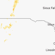
South Dakota
| Local Time | Report Details |
|---|---|
| 1:30 PM MDT | Quarter sized hail reported near Nemo, SD, 23.5 miles WNW of Rapid City, SD |
| 2:25 PM MDT | Quarter sized hail reported near Rapid City, SD, 17.3 miles WNW of Rapid City, SD, lots of heavy rain also |
| 2:41 PM MDT | Quarter sized hail reported near Rapid City, SD, 15 miles W of Rapid City, SD |
| 6:12 PM MDT | Quarter sized hail reported near Hill City, SD, 31.1 miles WSW of Rapid City, SD |
| 6:50 PM MDT | Quarter sized hail reported near Hill City, SD, 21.4 miles WSW of Rapid City, SD |
| 6:55 PM MDT | Storm damage reported in butte county SD, 79.3 miles NNW of Rapid City, SD |
| 7:16 PM MDT | Storm damage reported in butte county SD, 71.1 miles N of Rapid City, SD |
| 8:30 PM CDT | Storm damage reported in tripp county SD, 43.2 miles NE of Valentine, NE |
| 7:40 PM MDT | Quarter sized hail reported near Custer, SD, 39 miles SW of Rapid City, SD |
| 8:10 PM MDT | Storm damage reported in harding county SD, 118.3 miles N of Rapid City, SD |
| 8:53 PM MDT | Storm damage reported in perkins county SD, 109.2 miles SW of Bismarck, ND |
| 11:00 PM MDT | Storm damage reported in pennington county SD, 2.7 miles N of Rapid City, SD |
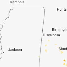
Alabama
| Local Time | Report Details |
|---|---|
| 2:50 PM CDT | Power lines down along kowaliga rd causing a grass fire. time estimated from rada in elmore county AL, 31.3 miles W of Auburn, AL |
| 3:00 PM CDT | Tree in roadway near the intersection of rifle range rd and rock springs rd. time estimated from rada in elmore county AL, 31.5 miles WSW of Auburn, AL |
| 3:30 PM CDT | Power lines down along barbour lane near eufaul in barbour county AL, 52.3 miles SSE of Auburn, AL |
| 3:45 PM CDT | Several trees down across the eastern part of the county including at slocomb high schoo in geneva county AL, 68.3 miles NE of Miramar Beach, FL |
| 3:54 PM CDT | Highway 27 blocked by fallen trees. tree down at 206 windcreek lan in coffee county AL, 71.2 miles NNE of Miramar Beach, FL |
| 3:55 PM CDT | Trees and power lines down. one tree feel onto an occupied vehicle at earline road and apache driv in houston county AL, 78.5 miles NE of Miramar Beach, FL |
| 4:17 PM CDT | Two trees down...one on cr46 and another on cr54. time estimated by rada in henry county AL, 72.8 miles S of Auburn, AL |
| 4:20 PM CDT | Quarter sized hail reported near Brewton, AL, 63.3 miles S of Camden, AL, public report of quarter size hail |
| 4:21 PM CDT | Tree down on baker avenu in geneva county AL, 54 miles NNE of Miramar Beach, FL |
| 4:30 PM CDT | Large tree down on county route 3 in dale county AL, 77.1 miles NE of Miramar Beach, FL |
| 4:30 PM CDT | Trees down at state route 123 and county route 4 in dale county AL, 79.3 miles NE of Miramar Beach, FL |
| 4:42 PM CDT | Quarter sized hail reported near Brewton, AL, 63.3 miles S of Camden, AL, public report of quarter size hail |
| 5:05 PM CDT | Roof damage to hangar at the old brundidge municipal airport. winds estimated at 40-50 mph based on rada in pike county AL, 63.5 miles SSW of Auburn, AL |
| 5:30 PM CDT | Quarter sized hail reported near Greenville, AL, 40.4 miles ESE of Camden, AL, quarter hail reported downtown greenville at 530 pm. |
| 6:45 PM CDT | Tree down in whitehouse fork in baldwin county AL, 16.8 miles ENE of Mobile, AL |
| 7:00 PM CDT | Power line down on hwy. 31 in daphn in baldwin county AL, 10.9 miles ESE of Mobile, AL |
| 7:50 PM CDT | Dauphin island police report entire island without power...power outage occurred at time of gust on the islan in mobile county AL, 29.7 miles S of Mobile, AL |
Texas
| Local Time | Report Details |
|---|---|
| 3:30 PM CDT | Trees blown down at woodlands pkwy and panther cree in montgomery county TX, 28.5 miles NNW of Houston, TX |
Wisconsin
| Local Time | Report Details |
|---|---|
| 3:40 PM CDT | Trees down across the city. power lines down. some power outages. delayed report. time estimated by rada in outagamie county WI, 26 miles SW of Green Bay, WI |
| 3:41 PM CDT | Tree down. delayed report. time estimated by rada in outagamie county WI, 21.4 miles SW of Green Bay, WI |
| 3:45 PM CDT | Storm damage reported in calumet county WI, 27.5 miles SW of Green Bay, WI |
| 3:45 PM CDT | Quarter sized hail reported near Appleton, WI, 26.8 miles SW of Green Bay, WI, report received via facebook from wfrv-tv. time of event is estimated and originial source of report is unknown. |
| 4:32 PM CDT | Storm damage reported in fond du lac county WI, 56.6 miles SSW of Green Bay, WI |
| 4:33 PM CDT | 3 foot diameter oak tree dow in fond du lac county WI, 56.6 miles SSW of Green Bay, WI |
| 4:35 PM CDT | Trees...branches...and power lines down across the cit in fond du lac county WI, 55.1 miles SSW of Green Bay, WI |
| 7:22 PM CDT | 2 trees dow in adams county WI, 77.2 miles ENE of La Crosse, WI |
Vermont
| Local Time | Report Details |
|---|---|
| 4:42 PM EDT | 8 trees and multiple powerlines down on falls road in chittenden county VT, 7.4 miles S of Burlington, VT |
| 5:00 PM EDT | Tree down on river road near rte 7 in addison county VT, 28.8 miles S of Burlington, VT |
| 5:12 PM EDT | Tree down in addison county VT, 31.6 miles S of Burlington, VT |
| 5:54 PM EDT | Several trees down on happy hollow and rainbow roads in windsor county VT, 56 miles SE of Burlington, VT |
| 6:12 PM EDT | Numerous roads impassable due to trees down in orange county VT, 65.4 miles SE of Burlington, VT |
| 6:12 PM EDT | Numerous roads imppassable due to trees down in orange county VT, 65.4 miles SE of Burlington, VT |
| 7:54 PM EDT | Tree down in rutland county VT, 60.5 miles S of Burlington, VT |
| 9:06 PM EDT | Trees and power lines down at north beach in chittenden county VT, 1.6 miles NW of Burlington, VT |
| 9:10 PM EDT | Quarter sized hail reported near Burlington, VT, 3.8 miles NW of Burlington, VT, quarter-sized hail |
| 9:12 PM EDT | Half Dollar sized hail reported near Burlington, VT, 0.3 miles NNE of Burlington, VT, half-dollar sized hail |
| 9:13 PM EDT | Ping Pong Ball sized hail reported near Burlington, VT, 1.6 miles NW of Burlington, VT |
| 9:15 PM EDT | Quarter sized hail reported near Colchester, VT, 2.4 miles NNE of Burlington, VT, quarter sized hail |
| 9:15 PM EDT | Quarter sized hail reported near Colchester, VT, 5.4 miles NE of Burlington, VT, quarter-sized hail |
| 9:15 PM EDT | Ping Pong Ball sized hail reported near Essex Junction, VT, 6.2 miles E of Burlington, VT |
| 9:20 PM EDT | Trees down in chittenden county VT, 1.5 miles NE of Burlington, VT |
| 9:20 PM EDT | Quarter sized hail reported near Williston, VT, 8.1 miles E of Burlington, VT, quarter-sized hail |
| 9:22 PM EDT | Ping Pong Ball sized hail reported near Winooski, VT, 1.5 miles NE of Burlington, VT, ping pong ball sized hail |
Nebraska
| Local Time | Report Details |
|---|---|
| 2:45 PM MDT | Quarter sized hail reported near Chappell, NE, 65.3 miles NNE of Yuma, CO, few quarter size hail stones occurring at time of report. |
| 2:45 PM MDT | Quarter sized hail reported near Chappell, NE, 68.3 miles N of Yuma, CO, few quarter size hail stones occurring at time of report. |
Indiana
| Local Time | Report Details |
|---|---|
| 5:12 PM EDT | Tree down at 300e and wabash rd in miami county IN, 52.7 miles WSW of Fort Wayne, IN |
| 5:40 PM EDT | Tree of unknown size and health down on road. power outage. scattered 1-inch tree limbs down along or near state route 67. time estimate in owen county IN, 40 miles SW of Indianapolis, IN |
| 5:40 PM EDT | Tree with radius of 14 to 16 inches and small dead core down on road. power outage. scattered 1-inch tree limbs down along or near state route 67. time estimate in owen county IN, 40 miles SW of Indianapolis, IN |
| 6:10 PM EDT | Quarter sized hail reported near Jonesville, IN, 50.7 miles SSE of Indianapolis, IN, time estimated from radar. location approximated. |
| 6:33 PM EDT | Tree with approx 1 foot diameter down at poplar and pearl streets. street flooding to 6 inches dept in hancock county IN, 19.9 miles NE of Indianapolis, IN |
| 6:40 PM EDT | Quarter sized hail reported near Indianapolis, IN, 10.7 miles E of Indianapolis, IN, pea size to quarter size hail fell for 5 minutes |
| 6:54 PM EDT | Small to medium size tree limbs down in jackson county IN, 58.7 miles SSE of Indianapolis, IN |
| 8:23 PM EDT | Powerline down at 1290n and 300e in lagrange county IN, 42.4 miles NNW of Fort Wayne, IN |
| 8:34 PM EDT | Tree down and landed on suv in west side of downtown lagrange in lagrange county IN, 42.4 miles NNW of Fort Wayne, IN |
| 8:35 PM EDT | Several trees downed and power outages countywide relayed by media in lagrange county IN, 42.4 miles NNW of Fort Wayne, IN |
| 9:09 PM EDT | Tree down at 600w and us20 in steuben county IN, 38.6 miles N of Fort Wayne, IN |
Wyoming
| Local Time | Report Details |
|---|---|
| 3:27 PM MDT | Storm damage reported in campbell county WY, 4.1 miles SSE of Gillette, WY |
| 3:30 PM MDT | Quarter sized hail reported near Moorcroft, WY, 34.5 miles E of Gillette, WY |
| 3:38 PM MDT | Storm damage reported in campbell county WY, 9.3 miles SE of Gillette, WY |
| 3:55 PM MDT | Very heavy rainfall in crook county WY, 37.2 miles ENE of Gillette, WY |
| 3:55 PM MDT | North side of a roof was blown off a 4 bay shop. roof landed about 200 ft away from the building. lots of siding damage on homes throughout the are in campbell county WY, 15.7 miles E of Gillette, WY |
| 3:55 PM MDT | Quarter sized hail reported near Osage, WY, 54.1 miles ESE of Gillette, WY, rainfall total of 0.76 inch |
| 3:58 PM MDT | Half Dollar sized hail reported near Rozet, WY, 14.2 miles E of Gillette, WY, ground white with hail |
| 3:58 PM MDT | Very heavy rain in campbell county WY, 13.7 miles ENE of Gillette, WY |
| 3:58 PM MDT | Tree damage in campbell county WY, 14.2 miles E of Gillette, WY |
| 4:00 PM MDT | 18 inch cottonwood tree trunk snappe in campbell county WY, 19.7 miles E of Gillette, WY |
| 4:00 PM MDT | Straight line winds caused a portion of a roof on a house to be peeled up at the eves. also damage to a shop with one wall bowed out 6 to 8 inches. both buildings were in campbell county WY, 20.6 miles ENE of Gillette, WY |
| 4:20 PM MDT | Storm damage reported in crook county WY, 27.6 miles E of Gillette, WY |
| 4:45 PM MDT | Wind gusting over 60 mph for 10 minutes - 445 pm to 455 pm. 1/2 inch hai in crook county WY, 43 miles NE of Gillette, WY |
| 4:55 PM MDT | Wind gusts over 60 mph began at 445 pm and continued through 455 pm. 1/2 inch hail also reporte in crook county WY, 43 miles NE of Gillette, WY |
New Hampshire
| Local Time | Report Details |
|---|---|
| 5:27 PM EDT | Large branches down in grafton county NH, 73.8 miles ESE of Burlington, VT |
| 6:25 PM EDT | 12-18 inch diameter trees dow in grafton county NH, 69.7 miles SE of Burlington, VT |
| 6:28 PM EDT | Hanover police say trees are down all over. event still ongoin in grafton county NH, 70.6 miles SE of Burlington, VT |
| 6:30 PM EDT | Trees down all over town in grafton county NH, 75 miles SE of Burlington, VT |
| 6:45 PM EDT | Downed tree across road in danbur in merrimack county NH, 80.9 miles W of Portland, ME |
| 6:45 PM EDT | Trees and wires down in moultonboroug in carroll county NH, 57.6 miles W of Portland, ME |
| 6:50 PM EDT | Large branches and trees down in merrimack county NH, 71.6 miles WSW of Portland, ME |
| 6:51 PM EDT | Tree down on murray hill road in hil in merrimack county NH, 73.1 miles W of Portland, ME |
| 6:51 PM EDT | Public reported large branches broken in tilto in belknap county NH, 68.6 miles WSW of Portland, ME |
| 6:53 PM EDT | Tree down on house on lawrence street in andover in merrimack county NH, 79.9 miles W of Portland, ME |
| 6:55 PM EDT | Tree and wires down in sanbornto in belknap county NH, 67.4 miles W of Portland, ME |
| 7:00 PM EDT | Multiple reports of trees and wires down in frankli in merrimack county NH, 71.6 miles WSW of Portland, ME |
| 7:00 PM EDT | Tree and wires down in tilto in belknap county NH, 68.6 miles WSW of Portland, ME |
| 7:04 PM EDT | Multiple reports of trees and wires dow in belknap county NH, 61.5 miles W of Portland, ME |
| 7:05 PM EDT | Multiple trees down in belmon in belknap county NH, 63.1 miles WSW of Portland, ME |
| 7:15 PM EDT | Many trees down and a garage damaged near crystal lake in gilmanton iron work in belknap county NH, 57.8 miles WSW of Portland, ME |
| 7:15 PM EDT | Observer estimated 60 mph... heard reports of wind damage on scanner from the towns of laconia... gilford in belknap county NH, 58.8 miles W of Portland, ME |
| 7:20 PM EDT | Tree down blocking route 140 in alto in belknap county NH, 50.5 miles WSW of Portland, ME |
| 7:25 PM EDT | Tree down on province road in barnstea in belknap county NH, 56.7 miles WSW of Portland, ME |
| 7:25 PM EDT | Public reported trees down in center barnstea in belknap county NH, 54.8 miles WSW of Portland, ME |
| 7:33 PM EDT | Observer estimated 60 mph... heard reports of wind damagae on scanner from the towns of laconia... gilford in belknap county NH, 58.8 miles W of Portland, ME |
| 7:33 PM EDT | Observer estimated 60 mph... heard reports of wind damage on scanner from the towns of laconia... gilford in belknap county NH, 58.8 miles W of Portland, ME |
| 7:38 PM EDT | Microburst...hundreds of trees blown dow in merrimack county NH, 78.6 miles WSW of Portland, ME |
| 7:45 PM EDT | Large branches and power lines dow in strafford county NH, 44 miles SW of Portland, ME |
| 8:11 PM EDT | Tree down at river road and castle driv in hillsborough county NH, 75.9 miles SW of Portland, ME |
| 8:11 PM EDT | Tree down on castle drive in hillsborough county NH, 75.9 miles SW of Portland, ME |
| 12:00 AM EDT | Several trees down on orfordvile road in grafton county NH, 69.8 miles SE of Burlington, VT |
| 12:20 AM EDT | Trees down on prescott hill road in grafton county NH, 85.2 miles W of Portland, ME |
Colorado
| Local Time | Report Details |
|---|---|
| 3:30 PM MDT | Quarter sized hail reported near Haxtun, CO, 38.5 miles N of Yuma, CO |
Oregon
| Local Time | Report Details |
|---|---|
| 3:35 PM PDT | Quarter sized hail reported near La Grande, OR, 56 miles S of Walla Walla, WA |
| 4:15 PM PDT | Golf Ball sized hail reported near Heppner, OR, 74.3 miles SW of Walla Walla, WA |
| 4:30 PM PDT | Quarter sized hail reported near Heppner, OR, 71.5 miles SW of Walla Walla, WA, hail the size of a quarter in diameter was reported with some minor creek flash flooding around 530 pm. |
| 4:46 PM PDT | Quarter sized hail reported near Heppner, OR, 76.8 miles SW of Walla Walla, WA |
| 5:00 PM PDT | Quarter sized hail reported near Elgin, OR, 41.9 miles SE of Walla Walla, WA, 20 minutes of hail fell around 5 pm and covered the ground. several hail stones were at least 1 inch in diameter or slightly larger. |
| 5:35 PM PDT | Quarter sized hail reported near Wallowa, OR, 51.9 miles SE of Walla Walla, WA, heavy hail currently falling largest hail stones are the size of a quarter in diameter with several penny sized hail stones as well. no significant wind to report with |
Michigan
| Local Time | Report Details |
|---|---|
| 7:08 PM EDT | 2 foot diameter healthy tree snapped in half and leaning over towards his house. numerous limbs dow in oceana county MI, 61.4 miles NW of Grand Rapids, MI |
| 7:12 PM EDT | Numerous tree branches dow in oceana county MI, 62.8 miles NNW of Grand Rapids, MI |
| 7:26 PM EDT | Numerous reports of trees and power lines dow in oceana county MI, 61.4 miles NW of Grand Rapids, MI |
| 7:35 PM EDT | Reports of trees down in fremont from 911 call center in newayg in newaygo county MI, 37.3 miles NNW of Grand Rapids, MI |
| 8:00 PM EDT | 5 inch limbs dow in osceola county MI, 62.1 miles N of Grand Rapids, MI |
| 8:48 PM EDT | 911 in stanton received reports of a couple of trees down near lake montcalm...just west of stanto in montcalm county MI, 35.7 miles NE of Grand Rapids, MI |
| 9:00 PM EDT | 911 in stanton received reports of a couple of trees down near lake montcalm...just west of stanto in montcalm county MI, 35.7 miles NE of Grand Rapids, MI |
Montana
| Local Time | Report Details |
|---|---|
| 5:13 PM MDT | Storm damage reported in phillips county MT, 74.2 miles ESE of Havre, MT |
Idaho
| Local Time | Report Details |
|---|---|
| 6:12 PM PDT | Golf Ball sized hail reported near Cottonwood, ID, 14.1 miles NW of Grangeville, ID, public reported golf ball size hail at hospital in cottonwood idaho |
| 7:30 PM PDT | Gust reported at corral creek raws. occurred between 701-801pm in lewis county ID, 36.5 miles NW of Grangeville, ID |
| 7:30 PM PDT | Gust reported at mission creek raws. occurred between 701-801 pm pd in lewis county ID, 36.5 miles NW of Grangeville, ID |
Missouri
| Local Time | Report Details |
|---|---|
| 8:30 PM CDT | Delayed report...branches down and brief power outage...winds estimated at 60 mph in buchanan county MO, 38.4 miles NNW of Kansas City, MO |
Connect with Interactive Hail Maps