

Hail Map for Sunday, July 2, 2017

Number of Impacted Households on 7/2/2017
0
Impacted by 1" or Larger Hail
0
Impacted by 1.75" or Larger Hail
0
Impacted by 2.5" or Larger Hail
Square Miles of Populated Area Impacted on 7/2/2017
0
Impacted by 1" or Larger Hail
0
Impacted by 1.75" or Larger Hail
0
Impacted by 2.5" or Larger Hail


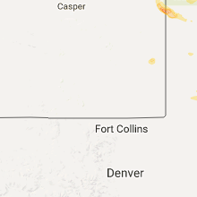


Cities Most Affected by Hail Storms of 7/2/2017
| Hail Size | Demographics of Zip Codes Affected | ||||||
|---|---|---|---|---|---|---|---|
| City | Count | Average | Largest | Pop Density | House Value | Income | Age |
| Mullen, NE | 1 | 1.75 | 1.75 | 0 | $41k | $28.7k | 49.6 |
| Lakeside, NE | 1 | 1.75 | 1.75 | 0 | $33k | $30.8k | 39.9 |
| Stapleton, NE | 1 | 1.75 | 1.75 | 1 | $53k | $33.9k | 45.0 |
Hail and Wind Damage Spotted on 7/2/2017
Filter by Report Type:Hail ReportsWind Reports
States Impacted
Oklahoma, Georgia, Tennessee, Wisconsin, Colorado, Nebraska, South Carolina, Utah, Wyoming, Illinois, North Dakota, Arkansas, Kansas, TexasOklahoma
| Local Time | Report Details |
|---|---|
| 2:25 PM CDT | Lots of utility poles snapped on 63rd st. near midwest blv in oklahoma county OK, 8.7 miles ENE of Oklahoma City, OK |
| 2:40 PM CDT | Quarter sized hail reported near Wellston, OK, 30.3 miles ENE of Oklahoma City, OK |
| 3:24 PM CDT | Storm damage reported in payne county OK, 38.9 miles NNE of Oklahoma City, OK |
| 3:30 PM CDT | 12-inch diameter tree downe in payne county OK, 51.6 miles NNE of Oklahoma City, OK |
| 3:56 PM CDT | Storm damage reported in lincoln county OK, 50.2 miles ENE of Oklahoma City, OK |
| 4:10 PM CDT | Byars sit in mcclain county OK, 51.5 miles SE of Oklahoma City, OK |
| 4:15 PM CDT | Byars sit in mcclain county OK, 51.5 miles SE of Oklahoma City, OK |
| 4:35 PM CDT | Large tree downed and across the road near pine st & craddock rd. relayed by e in pontotoc county OK, 39.8 miles NW of Atoka, OK |
| 4:55 PM CDT | Storm damage reported in tulsa county OK, 6.6 miles W of Tulsa, OK |
| 5:10 PM CDT | Quarter sized hail reported near Ringling, OK, 57 miles E of Wichita Falls, TX |
| 5:15 PM CDT | Large tree down in midtown. time estimated by rada in tulsa county OK, 4.3 miles ESE of Tulsa, OK |
| 5:20 PM CDT | Large tree limbs snapped near 33rd and peoria. time estimated by rada in tulsa county OK, 4.3 miles ESE of Tulsa, OK |
| 5:20 PM CDT | Storm damage reported in tulsa county OK, 9 miles ESE of Tulsa, OK |
| 5:25 PM CDT | Roof blown off of the masonic lodge. tree damage also observe in hughes county OK, 50.3 miles NNW of Atoka, OK |
| 5:30 PM CDT | One inch tree limbs broken... shingles blown off roo in rogers county OK, 14.8 miles E of Tulsa, OK |
| 5:36 PM CDT | One inch tree limbs broken... shingles blown off roo in wagoner county OK, 16.6 miles ESE of Tulsa, OK |
| 5:40 PM CDT | Near hwy 123 and county road 2495 west of bartlesvill in osage county OK, 39.4 miles N of Tulsa, OK |
| 6:18 PM CDT | Storm damage reported in carter county OK, 66.3 miles WSW of Atoka, OK |
| 6:18 PM CDT | North of wagoner. time estimated by rada in wagoner county OK, 35.8 miles ESE of Tulsa, OK |
| 6:18 PM CDT | North of wagoner. time estimated by rada in wagoner county OK, 35.8 miles ESE of Tulsa, OK |
| 6:21 PM CDT | Ping Pong Ball sized hail reported near Lone Grove, OK, 66.3 miles WSW of Atoka, OK |
| 9:55 PM CDT | Numerous utility poles downed and across the road in marshall county OK, 50 miles WSW of Atoka, OK |
| 10:09 PM CDT | Measured wind gust at the eoc in duran in bryan county OK, 30.5 miles SSW of Atoka, OK |
Georgia
| Local Time | Report Details |
|---|---|
| 4:17 PM EDT | One tree down on new franklin church rd and hwy 327. time estimated from rada in franklin county GA, 43.7 miles SW of Greenville, SC |
| 4:55 PM EDT | Tree reported down near the 300-block of e liberty street in savanna in chatham county GA, 0.7 miles S of Savannah, GA |
| 5:10 PM EDT | Three trees reported down in the bowman are in elbert county GA, 49.9 miles SSW of Greenville, SC |
| 5:18 PM EDT | A tree was reported down on a power line on arnold spence roa in cherokee county GA, 40.8 miles N of Atlanta, GA |
| 5:27 PM EDT | A small tree was reported down in the roadway on upper dowda mill road at lower dowda mill roa in cherokee county GA, 43.6 miles N of Atlanta, GA |
| 5:51 PM EDT | A tree was reported down in the roadway on reinhardt college parkway down from garland mountain trai in cherokee county GA, 42.7 miles NNW of Atlanta, GA |
| 5:59 PM EDT | 15-20 downed trees scattered along redbud way... gran forest drive... and haw creek drive. four trees down on homes. no injuries. time estimated from rada in forsyth county GA, 32.7 miles NNE of Atlanta, GA |
Tennessee
| Local Time | Report Details |
|---|---|
| 3:55 PM CDT | Image of a tree split. also several reports of pea size hail. time estimated based on rada in davidson county TN, 14.5 miles WSW of Nashville, TN |
| 3:57 PM CDT | Several large trees down in the riverwalk are in davidson county TN, 14 miles WSW of Nashville, TN |
| 4:06 PM CDT | Image of a tree split. also several reports of pea size hai in davidson county TN, 14.5 miles WSW of Nashville, TN |
Wisconsin
| Local Time | Report Details |
|---|---|
| 4:02 PM CDT | Quarter sized hail reported near Cross Plains, WI, 12.4 miles WNW of Madison, WI |
| 4:05 PM CDT | Ping Pong Ball sized hail reported near Waunakee, WI, 10.2 miles NW of Madison, WI |
| 4:07 PM CDT | Quarter sized hail reported near Middleton, WI, 9 miles WNW of Madison, WI |
| 6:30 PM CDT | Quarter sized hail reported near Verona, WI, 12.4 miles WSW of Madison, WI |
Colorado
| Local Time | Report Details |
|---|---|
| 3:07 PM MDT | Ft carson airfield automated weather statio in el paso county CO, 36.2 miles NNW of Pueblo, CO |
| 3:31 PM MDT | Dry microburst winds estimated at 60 mph to 70 mph broke branches and knocked down trees in a residential area of brighto in adams county CO, 20.3 miles NNE of Denver, CO |
| 3:40 PM MDT | Dry microburst winds knocked down power lines in northeast brighton causing a small grass fir in adams county CO, 21.2 miles NNE of Denver, CO |
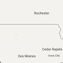
Nebraska
| Local Time | Report Details |
|---|---|
| 4:20 PM CDT | Quarter sized hail reported near Ord, NE, 55.2 miles NNW of Grand Island, NE, reported via twitter. |
| 3:35 PM MDT | Quarter sized hail reported near Mullen, NE, 67.1 miles NNW of North Platte, NE, nickel to quarter size hail. |
| 3:51 PM MDT | Quarter sized hail reported near Mullen, NE, 53.7 miles SSW of Valentine, NE, dime to quarter size hail. |
| 4:00 PM MDT | Quarter sized hail reported near Bingham, NE, 81.2 miles E of Scottsbluff, NE, estimated time of 5pm cdt report of quarter size hail. |
| 5:06 PM CDT | Ping Pong Ball sized hail reported near Comstock, NE, 63.5 miles SSW of Oneill, NE |
| 5:11 PM CDT | Half Dollar sized hail reported near Taylor, NE, 60.5 miles SW of Oneill, NE |
| 4:15 PM MDT | Golf Ball sized hail reported near Mullen, NE, 50.6 miles NNW of North Platte, NE, reported golf ball size hail at highway 92 by dismal river. |
| 5:20 PM CDT | Half Dollar sized hail reported near Comstock, NE, 64.2 miles NW of Grand Island, NE, relayed by dispatch from fire chief... report of half dollar size hail. |
| 5:22 PM CDT | Half Dollar sized hail reported near Comstock, NE, 64.2 miles NW of Grand Island, NE |
| 4:29 PM MDT | Quarter sized hail reported near Mullen, NE, 58.2 miles NNW of North Platte, NE |
| 4:32 PM MDT | Quarter sized hail reported near Ellsworth, NE, 74.4 miles ENE of Scottsbluff, NE |
| 4:36 PM MDT | Golf Ball sized hail reported near Lakeside, NE, 80.6 miles E of Scottsbluff, NE |
| 4:39 PM MDT | Ping Pong Ball sized hail reported near Mullen, NE, 57.3 miles NNW of North Platte, NE, ping pong... golf ball and quarter size hail covering the ground. |
| 4:50 PM MDT | Quarter sized hail reported near Hay Springs, NE, 75.3 miles NE of Scottsbluff, NE |
| 5:07 PM MDT | Quarter sized hail reported near Hyannis, NE, 67.2 miles NW of North Platte, NE, pea to quarter size hail. |
| 5:24 PM MDT | Quarter sized hail reported near Whitman, NE, 62.3 miles NW of North Platte, NE, very hard hail to the size of quarters. |
| 6:39 PM CDT | Quarter sized hail reported near Broken Bow, NE, 60 miles ENE of North Platte, NE, hail from dime to quarter size. |
| 6:43 PM CDT | Quarter sized hail reported near Tryon, NE, 30.7 miles NNW of North Platte, NE, hail to the size of quarters. |
| 6:01 PM MDT | Half Dollar sized hail reported near Harrison, NE, 63.6 miles N of Scottsbluff, NE, quarter to half dollar size hail. |
| 7:07 PM CDT | Quarter sized hail reported near Stapleton, NE, 18.4 miles NNE of North Platte, NE, relay from keith county. |
| 7:11 PM CDT | Golf Ball sized hail reported near Stapleton, NE, 15.9 miles NNE of North Platte, NE, report via social media. |
| 6:28 PM MDT | Quarter sized hail reported near Sidney, NE, 56.3 miles SE of Scottsbluff, NE, nickel to quarter size hail. |
| 7:30 PM CDT | Hillcrest site in lincoln county NE, 3 miles N of North Platte, NE |
| 7:35 PM CDT | Report from husker inn of 60 mph winds with dime size hai in lincoln county NE, 0.6 miles SW of North Platte, NE |
| 6:44 PM MDT | Storm damage reported in keith county NE, 47 miles W of North Platte, NE |
| 7:03 PM MDT | Storm damage reported in keith county NE, 35.7 miles W of North Platte, NE |
| 8:12 PM CDT | Quarter sized hail reported near Gothenburg, NE, 33.3 miles ESE of North Platte, NE, trained spotter reports hail up to the size of quarters. |
| 8:13 PM CDT | Half Dollar sized hail reported near Gothenburg, NE, 34.6 miles ESE of North Platte, NE, hail to the size of half dollars reported in gothenburg. |
| 8:28 PM CDT | 50-60 mph wind gusts estimate in lincoln county NE, 26.7 miles S of North Platte, NE |
| 8:40 PM CDT | Quarter sized hail reported near Gothenburg, NE, 34.6 miles ESE of North Platte, NE, trained spotter reported hail to the size of quarters in gothenburg. |
| 8:46 PM CDT | Quarter sized hail reported near Farnam, NE, 39.7 miles SE of North Platte, NE, public report of quarter size hail. |
| 7:46 PM MDT | 53-kt gus in box butte county NE, 46.5 miles ENE of Scottsbluff, NE |
| 9:04 PM CDT | Quarter sized hail reported near Farnam, NE, 41.3 miles SE of North Platte, NE |
| 9:05 PM CDT | Storm damage reported in hayes county NE, 45.3 miles SSW of North Platte, NE |
| 9:07 PM CDT | Trained spotter estimated 70 mph wind gus in furnas county NE, 65.4 miles SSE of North Platte, NE |
| 9:13 PM CDT | Storm damage reported in frontier county NE, 56.8 miles SE of North Platte, NE |
| 9:17 PM CDT | Storm spotter estimated wind gusts of 60 mp in red willow county NE, 59.8 miles NNE of Colby, KS |
| 9:18 PM CDT | Storm damage reported in furnas county NE, 65.5 miles SSE of North Platte, NE |
| 9:22 PM CDT | Quarter sized hail reported near Eustis, NE, 56.8 miles SE of North Platte, NE |
| 9:30 PM CDT | Dispatch reported numerous calls of wind damage and fires started by lightning across the count in hitchcock county NE, 52.9 miles N of Colby, KS |
| 9:36 PM CDT | Wind gust of 59 mph reported by spotte in hitchcock county NE, 52.5 miles NNE of Colby, KS |
| 9:38 PM CDT | Quarter sized hail reported near Holbrook, NE, 64.9 miles SE of North Platte, NE |
| 9:40 PM CDT | Site moorenoi measured a 75 mph wind gust in red willow county NE, 63.8 miles SSE of North Platte, NE |
| 9:43 PM CDT | Spotter reported 60 mph wind gust. time estimated by rada in red willow county NE, 63.9 miles NE of Colby, KS |
| 9:46 PM CDT | Half Dollar sized hail reported near Cambridge, NE, 59 miles SSE of North Platte, NE |
| 9:58 PM CDT | Quarter sized hail reported near Holbrook, NE, 69.4 miles SE of North Platte, NE, trained spotter reported heavy rain and hail to the size of quarters. |
| 10:00 PM CDT | 75 to 80 mph wind gust in furnas county NE, 82.5 miles NE of Colby, KS |
| 10:03 PM CDT | Half Dollar sized hail reported near Arapahoe, NE, 70.9 miles SE of North Platte, NE, half dollar size hail and 67 mph wind gusts. heavy rainfall. |
South Carolina
| Local Time | Report Details |
|---|---|
| 6:55 PM EDT | Tree down blocking road at pumpkintown hwy and barnewood pl. time estimated from rada in pickens county SC, 13.9 miles N of Greenville, SC |
| 7:45 PM EDT | Tree down on pine creek dr and williamsburg d in greenville county SC, 12.8 miles ESE of Greenville, SC |
| 7:45 PM EDT | Tree down on a house on fargo st in mauldin. time estimated from rada in greenville county SC, 18 miles E of Greenville, SC |
Utah
| Local Time | Report Details |
|---|---|
| 5:00 PM MDT | Us-40 at starvation in duchesne county UT, 42.8 miles NNE of Price, UT |
Wyoming
| Local Time | Report Details |
|---|---|
| 5:15 PM MDT | Ping Pong Ball sized hail reported near Lusk, WY, 83 miles NNW of Scottsbluff, NE, quarter to ping pong ball size hailstones. |
| 8:35 PM MDT | Quarter sized hail reported near Veteran, WY, 36.1 miles WNW of Scottsbluff, NE, marble to quarter size hail. |
Illinois
| Local Time | Report Details |
|---|---|
| 6:19 PM CDT | Numerous tree limbs 3-4 inches in diameter blown dow in cook county IL, 22.4 miles S of Chicago, IL |
North Dakota
| Local Time | Report Details |
|---|---|
| 5:34 PM MDT | Strong winds lasted 10 minutes. corrected for start tim in golden valley county ND, 85.7 miles SSW of Williston, ND |
| 5:37 PM MDT | Strong winds lasted 10 minute in golden valley county ND, 85.7 miles SSW of Williston, ND |
Arkansas
| Local Time | Report Details |
|---|---|
| 6:50 PM CDT | Quarter sized hail reported near Rogers, AR, 67.6 miles NNE of Fort Smith, AR, penny to quarter size hail east of rogers. |
| 7:00 PM CDT | One inch tree limbs broken... shingle damag in benton county AR, 70.5 miles SW of Springfield, MO |
Kansas
| Local Time | Report Details |
|---|---|
| 9:59 PM CDT | Koin awos site recorded 67 mph gus in decatur county KS, 40.1 miles NE of Colby, KS |
| 10:59 PM CDT | Knrn measured a 56 kt wind gust in norton county KS, 68.8 miles ENE of Colby, KS |
| 11:24 PM CDT | Storm damage reported in phillips county KS, 56 miles NNW of Hays, KS |
| 11:36 PM CDT | Pkwnd so far 62 mph 1139 p in phillips county KS, 60 miles N of Hays, KS |
| 11:42 PM CDT | Storm damage reported in phillips county KS, 60 miles N of Hays, KS |
| 11:45 PM CDT | Time est fm rada in phillips county KS, 55.6 miles N of Hays, KS |
| 12:25 AM CDT | Kansas state univ sit in osborne county KS, 52.4 miles NE of Hays, KS |
Texas
| Local Time | Report Details |
|---|---|
| 10:34 PM CDT | Quarter sized hail reported near Bushland, TX, 12.8 miles W of Amarillo, TX, some quarters within the accumulating hail. |
| 10:46 PM CDT | Quarter sized hail reported near Bushland, TX, 12.8 miles W of Amarillo, TX, some quarters within the accumulating hail. |
| 12:15 AM CDT | Measured 58 mph wind gusts at bonham awo in fannin county TX, 54.9 miles S of Atoka, OK |
| 2:39 AM CDT | West texas mesonet report in briscoe county TX, 55.9 miles W of Childress, TX |
Connect with Interactive Hail Maps