

Hail Map for Saturday, July 25, 2020

Number of Impacted Households on 7/25/2020
0
Impacted by 1" or Larger Hail
0
Impacted by 1.75" or Larger Hail
0
Impacted by 2.5" or Larger Hail
Square Miles of Populated Area Impacted on 7/25/2020
0
Impacted by 1" or Larger Hail
0
Impacted by 1.75" or Larger Hail
0
Impacted by 2.5" or Larger Hail


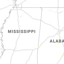


Cities Most Affected by Hail Storms of 7/25/2020
| Hail Size | Demographics of Zip Codes Affected | ||||||
|---|---|---|---|---|---|---|---|
| City | Count | Average | Largest | Pop Density | House Value | Income | Age |
| Ellijay, GA | 1 | 1.75 | 1.75 | 58 | $0k | $0.0k | 44.7 |
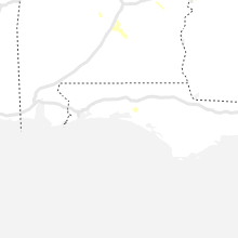
Hail and Wind Damage Spotted on 7/25/2020
Filter by Report Type:Hail ReportsWind Reports
States Impacted
Georgia, South Carolina, Alabama, North Dakota, Tennessee, South Dakota, North Carolina, Nebraska, Colorado, Minnesota, TexasGeorgia
| Local Time | Report Details |
|---|---|
| 2:05 PM EDT | Tree down in a yard on the 700th block of ives wa in gwinnett county GA, 19.6 miles NE of Atlanta, GA |
| 2:30 PM EDT | Quarter sized hail reported near Lawrenceville, GA, 30.6 miles NE of Atlanta, GA |
| 2:30 PM EDT | Power lines were reported down near the intersection of highway 15 s and sandersville highwa in hancock county GA, 56.5 miles WSW of Augusta, GA |
| 2:33 PM EDT | Half Dollar sized hail reported near Snellville, GA, 23.3 miles E of Atlanta, GA, half dollar sized hail reported along joseph eli drive. |
| 2:35 PM EDT | A tree was reported down on marben farm roa in jasper county GA, 43.2 miles ESE of Atlanta, GA |
| 2:55 PM EDT | A tree was reported down on thomas driv in putnam county GA, 71.2 miles SE of Atlanta, GA |
| 3:12 PM EDT | A tree was reported down near the intersection of highway 212 and twin bridges road s in putnam county GA, 67.6 miles SE of Atlanta, GA |
| 3:12 PM EDT | Two trees were reported down on eatonton highway between homer chiles road and stallings road in jones county GA, 67.7 miles SE of Atlanta, GA |
| 3:33 PM EDT | Two trees and several power lines were reported down along mcmahon road and also on hazelbrand roa in newton county GA, 35 miles ESE of Atlanta, GA |
| 3:48 PM EDT | A few trees were blown down across cannon driv in fayette county GA, 20 miles S of Atlanta, GA |
| 3:55 PM EDT | Four trees were blown down along sutton road. one tree fell partially in the roadway and another was reported on a ca in monroe county GA, 52.6 miles SSE of Atlanta, GA |
| 4:00 PM EDT | Tree down blocking road near the intersection of ga-83 and stokes store rd per gdo in monroe county GA, 51.7 miles SE of Atlanta, GA |
| 4:05 PM EDT | Multiple trees were reported down along dover trail in fayette county GA, 26.4 miles SSW of Atlanta, GA |
| 4:33 PM EDT | Quarter sized hail reported near Woodstock, GA, 25.3 miles NNW of Atlanta, GA, quarter sized hail was reported near the intersection of highway 92 and bascomb carmel road. |
| 4:33 PM EDT | Ping Pong Ball sized hail reported near Woodstock, GA, 24.6 miles NNW of Atlanta, GA, quarter to ping-pong ball sized hail was reported along fitchburg drive. |
| 4:33 PM EDT | Quarter sized hail reported near Woodstock, GA, 24.8 miles NNW of Atlanta, GA, quarter sized hail fell for about 5 minutes and began to accumulate. |
| 4:33 PM EDT | Two trees and several power lines were reported down along mcmahon road and also on hazelbrand roa in newton county GA, 35 miles ESE of Atlanta, GA |
| 4:48 PM EDT | Multiple trees were reported down along roberts quarters roa in pike county GA, 45.4 miles S of Atlanta, GA |
| 4:55 PM EDT | Quarter sized hail reported near Bowdon, GA, 51 miles WSW of Atlanta, GA, quarter inch hail was reported in bowden... 1 mile east of the police department. |
| 5:01 PM EDT | Half Dollar sized hail reported near Blairsville, GA, 72.9 miles E of Chattanooga, TN, half dollar sized hail fell for about 3 minutes. |
| 5:12 PM EDT | Quarter sized hail reported near Greenville, GA, 52.8 miles SSW of Atlanta, GA, quarter sized hail fell for 2 minutes. |
| 5:13 PM EDT | Three trees were reported down along lee lane. two trees were blown into the roadway with another into a yar in meriwether county GA, 50.4 miles SSW of Atlanta, GA |
| 5:20 PM EDT | Multiple trees were reported down on jefferson street in mancheste in meriwether county GA, 54.2 miles ENE of Auburn, AL |
| 5:44 PM EDT | Trees were reported down on power lines in the 200 block of tant road. nearby in the 100 block of rodgers cut off an additional tree was reported down on powerline in bartow county GA, 47.7 miles NW of Atlanta, GA |
| 5:50 PM EDT | Golf Ball sized hail reported near Ellijay, GA, 60.1 miles ESE of Chattanooga, TN, quarter to golf-ball sized hail was reported near the intersection of highway 52 and rackley road. |
| 5:54 PM EDT | A tree was reported down near the intersection of cassville road and james avenu in bartow county GA, 39.7 miles NW of Atlanta, GA |
| 6:00 PM EDT | A tree was reported down near the intersection of 4th street and field stree in laurens county GA, 72.4 miles N of Douglas, GA |
| 6:05 PM EDT | Quarter sized hail reported near Columbus, GA, 36.8 miles ESE of Auburn, AL, dime to quarter sized hail was reported near carver park. |
| 6:10 PM EDT | At tree was reported down on chulio roa in floyd county GA, 53.1 miles NW of Atlanta, GA |
| 6:10 PM EDT | Two trees were reported down on old wire roa in talbot county GA, 55.7 miles E of Auburn, AL |
| 6:11 PM EDT | A tree was reported down in the roadway on northgate driv in muscogee county GA, 33.5 miles ESE of Auburn, AL |
| 6:20 PM EDT | A tree was reported down along shaw stree in bartow county GA, 46.3 miles NW of Atlanta, GA |
| 6:21 PM EDT | Csg asos reported a 52kt wind gust at at 6:21 p in muscogee county GA, 32.2 miles E of Auburn, AL |
| 6:27 PM EDT | A tree was reported down on shannon circl in floyd county GA, 50.3 miles SSE of Chattanooga, TN |
| 6:43 PM EDT | A tree was reported down near the intersection of pridgen road and highway 11 in laurens county GA, 63.3 miles N of Douglas, GA |
| 6:46 PM EDT | A tree was reported down in the roadwa in bartow county GA, 46.5 miles NNW of Atlanta, GA |
| 6:50 PM EDT | Multiple trees were reported down along commanche roa in muscogee county GA, 28.7 miles E of Auburn, AL |
| 6:53 PM EDT | A tree was reported down near the intersection of s drive and park plac in laurens county GA, 71.4 miles N of Douglas, GA |
South Carolina
| Local Time | Report Details |
|---|---|
| 2:29 PM EDT | Schp reported tree on roadway at keeler mill road and silvers road. time estimated with rada in greenville county SC, 11.8 miles NNE of Greenville, SC |
| 2:38 PM EDT | 2 trees blown down by storm win in pickens county SC, 6.6 miles NE of Greenville, SC |
| 5:20 PM EDT | County dispatch received a report of a tree down on ellis road and abbeville st in due west. time estimated with radar in abbeville county SC, 37.4 miles SSE of Greenville, SC |
| 5:35 PM EDT | Highway patrol reported tree in roadway beth eden road at old whitmire highwa in newberry county SC, 63.4 miles NNE of Augusta, GA |
| 5:40 PM EDT | Highway patrol reported tree in roadway dennis dairy road at hawkins roa in newberry county SC, 56.9 miles NNE of Augusta, GA |
| 7:46 PM EDT | Trees and power lines down along charlotte highwa in york county SC, 22.6 miles SW of Charlotte, NC |
Alabama
| Local Time | Report Details |
|---|---|
| 3:55 PM CDT | Partial roof damage to a residence with a few trees down in the vicinity as well. time estimated from rada in barbour county AL, 57.7 miles S of Auburn, AL |
| 5:10 PM CDT | Tree down on newell s in tallapoosa county AL, 16.5 miles NW of Auburn, AL |
| 5:43 PM CDT | Power lines down in the 700 block of webster ford r in tallapoosa county AL, 19.2 miles W of Auburn, AL |
| 6:00 PM CDT | A few trees down in maplesvill in chilton county AL, 51.9 miles S of Birmingham, AL |
| 6:00 PM CDT | Tree down blocking cr 45 near the cemetar in chilton county AL, 54 miles S of Birmingham, AL |
| 6:15 PM CDT | Tree down near the intersection of tallassee hwy and neman rd. time estimate in elmore county AL, 29.1 miles W of Auburn, AL |
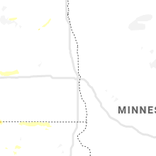
North Dakota
| Local Time | Report Details |
|---|---|
| 4:05 PM CDT | Quarter sized hail reported near Munich, ND, 47.6 miles N of Devils Lake, ND, mostly pea size hail... but a few larger stones. |
| 3:06 PM MDT | Half Dollar sized hail reported near Hettinger, ND, 104.9 miles WSW of Bismarck, ND, hail is ongoing at the time of the call. |
| 4:12 PM CDT | Ping Pong Ball sized hail reported near Wales, ND, 45.5 miles N of Devils Lake, ND, report received via broadcast media. time estimated via radar. |
| 6:32 PM CDT | Storm damage reported in sioux county ND, 45 miles S of Bismarck, ND |
| 8:02 PM CDT | Storm damage reported in emmons county ND, 40.5 miles SE of Bismarck, ND |
| 8:18 PM CDT | Storm damage reported in emmons county ND, 56.5 miles SE of Bismarck, ND |
| 8:30 PM CDT | Storm damage reported in emmons county ND, 44.8 miles SE of Bismarck, ND |
| 9:10 PM CDT | Quarter sized hail reported near Devils Lake, ND, 0.6 miles WSW of Devils Lake, ND |
Tennessee
| Local Time | Report Details |
|---|---|
| 5:30 PM EDT | Reports of multiple trees down across the county from hawkins co dispatc in hawkins county TN, 44.6 miles W of Bristol, TN |
South Dakota
| Local Time | Report Details |
|---|---|
| 3:59 PM MDT | Storm damage reported in perkins county SD, 91.2 miles SW of Bismarck, ND |
| 4:30 PM MDT | Trees and branches knocked down. nickle hail. time estimate in corson county SD, 78.7 miles SW of Bismarck, ND |
| 4:35 PM MDT | 60-70mph estimate... trees and limbs down. time estimate in corson county SD, 75.9 miles SW of Bismarck, ND |
| 4:48 PM MDT | A large barn was lost... and heavy tree damage occurred in the yard. time estimated from rada in sioux county ND, 61.8 miles SSW of Bismarck, ND |
| 4:50 PM MDT | 50-60mph winds with some limb damage. childrens playhouse blown across road. time estimate in corson county SD, 73.1 miles SW of Bismarck, ND |
| 4:54 PM MDT | Estimates 70 to 80 mph winds. lots of tree damage. time estimated from rada in sioux county ND, 59.4 miles SSW of Bismarck, ND |
| 5:44 PM MDT | Mesonet station 205 mclaughlin (sddot in corson county SD, 66.3 miles S of Bismarck, ND |
| 6:00 PM MDT | Mesonet station 205 mclaughlin (sddot in corson county SD, 66.3 miles S of Bismarck, ND |
| 7:29 PM CDT | Estimated around 65mph winds at current tim in campbell county SD, 66.8 miles SSE of Bismarck, ND |
| 10:05 PM CDT | Ping Pong Ball sized hail reported near Long Lake, SD, 47.9 miles NW of Aberdeen, SD, photo via social media. radar estimated time. |
| 12:27 AM CDT | Time estimated on rada in marshall county SD, 55.8 miles ENE of Aberdeen, SD |
| 1:25 AM CDT | Quarter sized hail reported near Bristol, SD, 36.7 miles ESE of Aberdeen, SD |
| 2:11 AM CDT | Storm damage reported in codington county SD, 70.8 miles W of Montevideo, MN |
| 2:25 AM CDT | Relayed by emergency manage in codington county SD, 58.7 miles W of Montevideo, MN |
North Carolina
| Local Time | Report Details |
|---|---|
| 6:36 PM EDT | Shopton fire department reported two trees down on shopton road wes in mecklenburg county NC, 9.6 miles WSW of Charlotte, NC |
Nebraska
| Local Time | Report Details |
|---|---|
| 7:08 PM CDT | 60 mph winds... blew over a shed... knocked out power. pea sized hai in blaine county NE, 57.4 miles SSE of Valentine, NE |
| 7:30 PM CDT | Auger flipped over. picture sent through social medi in blaine county NE, 60.5 miles SSE of Valentine, NE |
| 8:20 PM CDT | Estimated 70 mph wind gust. 4 to 6 inch tree limb broke in lincoln county NE, 3.2 miles S of North Platte, NE |
| 8:23 PM CDT | Estimated 70 mph wind gust. 4 to 6 inch tree limb broke in lincoln county NE, 3.2 miles S of North Platte, NE |
| 8:30 PM CDT | 70 mph wind gusts. w side of north platte in lincoln county NE, 0.6 miles SW of North Platte, NE |
| 8:31 PM CDT | 4 to 6 inch tree limb broken. 0.75 inch hail... est 50+mph in lincoln county NE, 5.3 miles S of North Platte, NE |
Colorado
| Local Time | Report Details |
|---|---|
| 6:45 PM MDT | Mesonet station tt563 south republica in yuma county CO, 46.5 miles SE of Yuma, CO |
Minnesota
| Local Time | Report Details |
|---|---|
| 2:04 AM CDT | Quarter sized hail reported near Norcross, MN, 69.4 miles NNW of Montevideo, MN, report received via social media. time estimated by radar. |
Texas
| Local Time | Report Details |
|---|---|
| 3:34 AM CDT | Public report of power lines down near california rd. and s dakota ave. possible tornado. time estimate in cameron county TX, 4.7 miles E of Brownsville, TX |
Connect with Interactive Hail Maps