

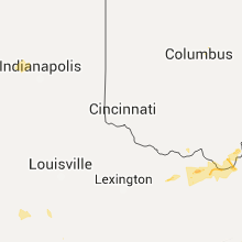
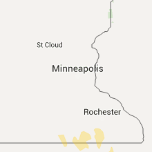
Hail Map for Wednesday, July 6, 2016

Number of Impacted Households on 7/6/2016
0
Impacted by 1" or Larger Hail
0
Impacted by 1.75" or Larger Hail
0
Impacted by 2.5" or Larger Hail
Square Miles of Populated Area Impacted on 7/6/2016
0
Impacted by 1" or Larger Hail
0
Impacted by 1.75" or Larger Hail
0
Impacted by 2.5" or Larger Hail


Cities Most Affected by Hail Storms of 7/6/2016
| Hail Size | Demographics of Zip Codes Affected | ||||||
|---|---|---|---|---|---|---|---|
| City | Count | Average | Largest | Pop Density | House Value | Income | Age |
| Union Center, SD | 2 | 2.50 | 2.50 | 0 | $45k | $27.9k | 40.8 |
| Box Elder, SD | 2 | 1.75 | 1.75 | 45 | $66k | $32.6k | 30.1 |
| North Platte, NE | 2 | 1.75 | 1.75 | 50 | $79k | $36.3k | 38.7 |
| White Owl, SD | 1 | 3.00 | 3.00 | 0 | $308k | $33.2k | 40.8 |
| Hershey, NE | 1 | 1.75 | 1.75 | 4 | $78k | $42.2k | 42.2 |
| Maxwell, NE | 1 | 1.75 | 1.75 | 1 | $52k | $32.3k | 41.6 |
| Arthur, NE | 1 | 1.75 | 1.75 | 0 | $48k | $30.5k | 43.8 |
| Stapleton, NE | 1 | 1.75 | 1.75 | 1 | $53k | $33.9k | 45.0 |
| Ellsworth AFB, SD | 1 | 1.75 | 1.75 | 497 | $29k | $33.1k | 21.4 |
Hail and Wind Damage Spotted on 7/6/2016
Filter by Report Type:Hail ReportsWind Reports
States Impacted
Illinois, Alabama, Iowa, Indiana, Missouri, Arkansas, Georgia, Nebraska, Kentucky, South Carolina, Florida, Ohio, Montana, Tennessee, South Dakota, North Dakota, Virginia, Wyoming, Mississippi, Texas, North Carolina, West Virginia, Oklahoma, Minnesota, KansasIllinois
| Local Time | Report Details |
|---|---|
| 7:12 AM CDT | Power lines down near airport. time estimate in coles county IL, 5.1 miles E of Mattoon, IL |
| 7:17 AM CDT | Trees down. time estimate in coles county IL, 11.5 miles E of Mattoon, IL |
| 7:24 AM CDT | Power lines down. time estimated from rada in cumberland county IL, 11.8 miles SSW of Mattoon, IL |
| 8:19 AM CDT | Trees and power lines down in crawford county IL, 40.3 miles SE of Mattoon, IL |
| 8:20 AM CDT | Trees down in crawford county IL, 41.6 miles SE of Mattoon, IL |
| 8:31 AM CDT | Tree down. power reported out in robinson...oblong..west union...hutsonville...annapoli in crawford county IL, 48.1 miles SE of Mattoon, IL |
| 8:31 AM CDT | Trees and power lines down in crawford county IL, 51.6 miles SE of Mattoon, IL |
| 8:45 AM CDT | Trees down in lawrence county IL, 57.1 miles N of Evansville, IN |
| 8:48 AM CDT | Trees down blocking route 1 in lawrence county IL, 53.1 miles N of Evansville, IN |
| 1:15 PM CDT | Large tree down. large limbs down...one on a car. estimated 70 mph. time estimate in pulaski county IL, 20.8 miles ESE of Cape Girardeau, MO |
| 1:25 PM CDT | 2-3 inch limbs dow in jackson county IL, 28.9 miles NNE of Cape Girardeau, MO |
| 1:49 PM CDT | Significant damage to trees. spotter report of 70 mph winds in metropoli in massac county IL, 46.1 miles ESE of Cape Girardeau, MO |
| 1:53 PM CDT | Power out at hospital additio in massac county IL, 46 miles ESE of Cape Girardeau, MO |
| 1:56 PM CDT | Power poles and trees snapped. roof damage. in massac county IL, 46.1 miles ESE of Cape Girardeau, MO |
| 2:00 PM CDT | Roof off of maintenance building. other outbuildings destroye in massac county IL, 47.2 miles ESE of Cape Girardeau, MO |
| 2:00 PM CDT | Over 30 trees down or uproote in massac county IL, 46.5 miles ESE of Cape Girardeau, MO |
Alabama
| Local Time | Report Details |
|---|---|
| 8:46 AM CDT | Tree limbs greater than 2 inches in diameter were downe in etowah county AL, 46.2 miles NE of Birmingham, AL |
| 9:00 AM CDT | *** 1 inj *** this is a correction to initial information of an injury on the gadsden state community college campus. the injury was caused by a falling tree branch. in etowah county AL, 57.3 miles NE of Birmingham, AL |
| 9:14 AM CDT | A large tree was downed along keeling roa in etowah county AL, 58.7 miles NE of Birmingham, AL |
| 12:13 PM CDT | Tree down blocking stuart tarter road near vivian adams school in dale county AL, 80 miles S of Auburn, AL |
| 1:28 PM CDT | Report of a tree down near banks in pike county. time estimated by rada in pike county AL, 58.8 miles SSW of Auburn, AL |
| 2:10 PM CDT | Tree reported down near fort deposit. time estimated by rada in lowndes county AL, 41.7 miles E of Camden, AL |
| 4:20 PM CDT | Two trees reported down on roadway of buyck road. estimated 40 to 50 mph winds. time estimated by rada in elmore county AL, 45.9 miles W of Auburn, AL |
| 4:25 PM CDT | Tree down near graham. estimated 40 to 50 mph winds. time estimated by radar. corrected event typ in randolph county AL, 57.1 miles WSW of Atlanta, GA |
Iowa
| Local Time | Report Details |
|---|---|
| 8:56 AM CDT | Power lines down in tow in wapello county IA, 55.3 miles NW of Kahoka, MO |
| 12:50 AM CDT | Extensive tree damage reported in the city. reported via city of fonda social media. time estimated by rada in pocahontas county IA, 18.3 miles ESE of Storm Lake, IA |
| 1:03 AM CDT | 12 inch in diameter tree limbs down. time estimated from rada in calhoun county IA, 34.7 miles ESE of Storm Lake, IA |
| 1:16 AM CDT | Measured by home weather statio in palo alto county IA, 33.3 miles NE of Storm Lake, IA |
| 1:16 AM CDT | Trees down in town. time estimated from rada in palo alto county IA, 41.5 miles NE of Storm Lake, IA |
| 1:39 AM CDT | Kossuth co. emergency manager reported extensive tree damage across the entire county due to straight line winds. burt... algona... swea city... luverne... bancroft wer in kossuth county IA, 52.7 miles W of Mason City, IA |
| 2:17 AM CDT | Large tree blocking highway 69 in winnebago county IA, 23.7 miles WNW of Mason City, IA |
| 2:24 AM CDT | Measured by kimt tv stormnet sit in cerro gordo county IA, 13.1 miles W of Mason City, IA |
| 2:30 AM CDT | Tree damage in town including very large tree uprooted. a few trees on vehicle in winnebago county IA, 25.6 miles NW of Mason City, IA |
| 2:40 AM CDT | Four trees 6-8 inches wide down and one 10-12 inch wide tree down. time estimated by radar and other report in worth county IA, 8.8 miles NNE of Mason City, IA |
| 2:50 AM CDT | Highway 65 blocked in both directions due to downed power lines. detour in effect. time estimated per rada in worth county IA, 19.6 miles N of Mason City, IA |
| 2:57 AM CDT | Measured by home weather statio in worth county IA, 14.1 miles NNE of Mason City, IA |
| 3:45 AM CDT | Roof off power plant in town as well as damage to chicken plant southwest of town. large branches down around town. time based on radar in montgomery county IA, 55.1 miles ESE of Omaha, NE |
Indiana
| Local Time | Report Details |
|---|---|
| 10:02 AM EDT | Tree downed. barn damage. wind estimated above 60 mp in greene county IN, 63.3 miles SW of Indianapolis, IN |
| 10:20 AM EDT | Tree downed on davis road. event time correcte in knox county IN, 54.7 miles N of Evansville, IN |
| 10:29 AM EDT | Tree downed on davis roa in knox county IN, 54.7 miles N of Evansville, IN |
| 10:32 AM EDT | Tree downed on power lines on holscher r in knox county IN, 37.5 miles N of Evansville, IN |
| 10:48 AM EDT | Tree downed on power lines at parkinson s in knox county IN, 48.6 miles N of Evansville, IN |
Missouri
| Local Time | Report Details |
|---|---|
| 9:10 AM CDT | Several trees down around the skyline near z hw in webster county MO, 24.2 miles ESE of Springfield, MO |
| 9:20 AM CDT | Tree blocking driveway near hwy b and cty rd 514 and several trees down along hwy b north of av in douglas county MO, 36.8 miles ESE of Springfield, MO |
| 9:30 AM CDT | Uprooted tree and multiple tree limbs dow in wright county MO, 39.9 miles E of Springfield, MO |
| 9:35 AM CDT | 4 inch limbs down on house south of macomb. power lines down at residence in wright county MO, 44.6 miles ESE of Springfield, MO |
| 9:42 AM CDT | Tree blocking driveway near hwy in douglas county MO, 36.8 miles ESE of Springfield, MO |
| 9:50 AM CDT | Several trees down around the skyline near z hw in webster county MO, 24.2 miles ESE of Springfield, MO |
| 9:55 AM CDT | Several trees down near hwy 95. tree on car near v hw in douglas county MO, 57 miles ESE of Springfield, MO |
| 10:10 AM CDT | Several reports of power lines and trees blown in willow springs in howell county MO, 50.6 miles SSW of Salem, MO |
| 10:26 AM CDT | Delayed report...cattle barn and trees blown down in linn county MO, 77.5 miles NW of Columbia, MO |
| 10:27 AM CDT | Damage to the roof of business in summersville in texas county MO, 32.2 miles SSW of Salem, MO |
| 10:50 AM CDT | Quarter sized hail reported near Columbia, MO, 0.3 miles SE of Columbia, MO |
| 10:55 AM CDT | Numerous 2-3 inch tree limbs down in brandsville in howell county MO, 68.6 miles S of Salem, MO |
| 11:05 AM CDT | Sizable tree down over road at rice and mckee in columbia in boone county MO, 0.3 miles SE of Columbia, MO |
| 11:05 AM CDT | Large tree down over f highway in koshkonong in oregon county MO, 71.8 miles S of Salem, MO |
| 11:20 AM CDT | Report of trees partially blocking the road in centerville in reynolds county MO, 34.4 miles ESE of Salem, MO |
| 11:30 AM CDT | Reports of trees down throughout lesterville in reynolds county MO, 40.6 miles ESE of Salem, MO |
| 11:42 AM CDT | Numerous trees and power lines down through the cit in iron county MO, 43.2 miles E of Salem, MO |
| 11:50 AM CDT | Power pole snapped in washington county MO, 42.8 miles ENE of Salem, MO |
| 11:51 AM CDT | Report of multiple trees down in st. francois county MO, 57.2 miles E of Salem, MO |
| 11:53 AM CDT | Some gusts higher than 60 mp in ripley county MO, 79.6 miles SSE of Salem, MO |
| 12:00 PM CDT | Auto zone sign blown down in farmington in st. francois county MO, 58.7 miles NW of Cape Girardeau, MO |
| 12:02 PM CDT | Reports of numerous trees down in park hills and surrounding communities in st. francois county MO, 56.6 miles SSW of Saint Louis, MO |
| 12:07 PM CDT | Report of two trees down at the intersection of bloomfield and hwy oo in madison county MO, 45.2 miles WNW of Cape Girardeau, MO |
| 12:07 PM CDT | Numerous trees and power lines dow in iron county MO, 49.1 miles E of Salem, MO |
| 12:15 PM CDT | Signs blown down. winds estimated at 55 mp in butler county MO, 61.2 miles SW of Cape Girardeau, MO |
| 12:20 PM CDT | Trees snapped and uproote in bollinger county MO, 30.8 miles WSW of Cape Girardeau, MO |
| 12:20 PM CDT | Top of tree snapped of in st. francois county MO, 52.4 miles SSW of Saint Louis, MO |
| 12:25 PM CDT | Construction trailer blown into ditch. lots of power outages. trees down. late repor in butler county MO, 60.3 miles SW of Cape Girardeau, MO |
| 12:25 PM CDT | Several trees down in town. power lines down to in butler county MO, 61.2 miles SW of Cape Girardeau, MO |
| 12:36 PM CDT | Several large trees down in ste. genevieve. other trees damaged throughout county as wel in ste. genevieve county MO, 46.1 miles S of Saint Louis, MO |
| 12:45 PM CDT | Several trees down on the west side of tow in cape girardeau county MO, 1.5 miles WNW of Cape Girardeau, MO |
| 12:50 PM CDT | Trees down. time estimate in cape girardeau county MO, 16.6 miles WNW of Cape Girardeau, MO |
| 12:53 PM CDT | Trees down north and south of dexte in stoddard county MO, 39.8 miles SSW of Cape Girardeau, MO |
| 12:55 PM CDT | Malden airport reported a 60 mph gus in dunklin county MO, 55.4 miles SSW of Cape Girardeau, MO |
| 12:55 PM CDT | Metal roof ripped off business downtown. power out in the business distric in stoddard county MO, 41.3 miles SSW of Cape Girardeau, MO |
| 12:55 PM CDT | One huge tree uprooted with multiple tree limbs down. time estimate in stoddard county MO, 49 miles SSW of Cape Girardeau, MO |
| 12:56 PM CDT | Time estimated. trees dow in scott county MO, 12.7 miles S of Cape Girardeau, MO |
| 1:04 PM CDT | Tree down in capaha park. via social medi in cape girardeau county MO, 0.4 miles WSW of Cape Girardeau, MO |
| 1:05 PM CDT | Winds estimated 65 mph. several trees down with power outages. there is also some corn field damage in cape girardeau county MO, 13.8 miles WSW of Cape Girardeau, MO |
| 1:10 PM CDT | Large tree feel into a house. split the house in two. time estimate in mississippi county MO, 38.6 miles SSE of Cape Girardeau, MO |
| 1:15 PM CDT | Trees dow in cape girardeau county MO, 16.6 miles WNW of Cape Girardeau, MO |
| 3:17 AM CDT | Tractor trailer flipped on its side near corning. i-29 close in holt county MO, 74.3 miles SSE of Omaha, NE |
| 3:25 AM CDT | Numerous trees/power lines down throughout the city. hwy 59 near fairfax closed due to grain bin in roa in atchison county MO, 69.8 miles SSE of Omaha, NE |
| 3:25 AM CDT | Trailer truck blown over on j highway west of tow in atchison county MO, 68.9 miles SSE of Omaha, NE |
| 3:30 AM CDT | Tree down. time est in holt county MO, 79.4 miles NNW of Kansas City, MO |
| 3:30 AM CDT | Large trees down. city is without powe in holt county MO, 79.7 miles SSE of Omaha, NE |
| 4:00 AM CDT | Power out and large trees down in the cit in nodaway county MO, 84.8 miles SE of Omaha, NE |
| 4:00 AM CDT | Power lines down in nodaway county MO, 86.2 miles N of Kansas City, MO |
| 4:23 AM CDT | Estimated 50 to 60 mph wind gusts. time estimated from rada in dekalb county MO, 56.3 miles NNE of Kansas City, MO |
| 4:35 AM CDT | Storm damage reported in platte county MO, 12.6 miles NNW of Kansas City, MO |
| 4:35 AM CDT | Trees dow in worth county MO, 86.5 miles SSW of Des Moines, IA |
| 4:44 AM CDT | Large tree limbs...6 inch plus...down all over. streets blocke in clay county MO, 6.8 miles N of Kansas City, MO |
| 5:10 AM CDT | Storm damage reported in jackson county MO, 8.8 miles E of Kansas City, MO |
| 5:10 AM CDT | 60 mph wind gust in the plaza area in jackson county MO, 0.3 miles SE of Kansas City, MO |
| 6:16 AM CDT | Estimated 55 to 60 mph wind in pettis county MO, 62.4 miles WSW of Columbia, MO |
| 6:25 AM CDT | Large tree down in roadway near hwy h. power line down near lincol in benton county MO, 66.7 miles SW of Columbia, MO |
| 6:25 AM CDT | Shed destroyed near lincol in benton county MO, 66.4 miles SW of Columbia, MO |
Arkansas
| Local Time | Report Details |
|---|---|
| 10:20 AM CDT | Trained spotter reported strong wind gusts and multiple powerlines down near highway 178 in lakevie in baxter county AR, 70.7 miles SE of Springfield, MO |
| 10:20 AM CDT | Trained spotter reported powerlines and large tree limbs down in gassvill in baxter county AR, 78 miles SE of Springfield, MO |
| 12:00 PM CDT | A large tree was down across highway 90 west near springview road. time is radar estimate in randolph county AR, 94.9 miles SSE of Salem, MO |
Georgia
| Local Time | Report Details |
|---|---|
| 12:00 PM EDT | Tree down blocking ga293 between iron belt road and grassdale roa in bartow county GA, 39.7 miles NW of Atlanta, GA |
| 12:20 PM EDT | 911 call center received report of several trees down on new mackland rd...cooper dr lake near the intersection of atlanta rd...paper mill rd...and maxwell avenue sw ne in cobb county GA, 17.2 miles NNW of Atlanta, GA |
| 12:30 PM EDT | Tree down on roadway...arnold mill r in cherokee county GA, 25.3 miles NNW of Atlanta, GA |
| 12:42 PM EDT | Tree down on west paces ferry road...near governors mansion in fulton county GA, 6.3 miles N of Atlanta, GA |
| 12:45 PM EDT | Large tree down along weatherstone way in the woodland hills area. time estimated from rada in dekalb county GA, 5.2 miles NE of Atlanta, GA |
| 12:48 PM EDT | Tree down on ga tech campus...knocked out power. over 10000 power outages reported in fulton in fulton county GA, 2.2 miles N of Atlanta, GA |
| 12:49 PM EDT | Trees down on powerlines at intersection of castlerock way and blarney way. time estimated from rada in gwinnett county GA, 19.9 miles NE of Atlanta, GA |
| 12:50 PM EDT | Roof and awning of valero gas station on shallowford road collapsed in cobb county GA, 19.1 miles NNW of Atlanta, GA |
| 12:50 PM EDT | Tree and powerline down across conferate ave se in fulton county GA, 2.2 miles SE of Atlanta, GA |
| 12:53 PM EDT | Trees and powerlines down on a house in the snellville area. time estimated by rada in gwinnett county GA, 22.3 miles ENE of Atlanta, GA |
| 12:54 PM EDT | Tree down on house on whitegrass way in gwinnett county GA, 27.7 miles ENE of Atlanta, GA |
| 12:54 PM EDT | Tree down on windward lane in gwinnett county GA, 18.7 miles NE of Atlanta, GA |
| 12:55 PM EDT | Several reports of trees down around the lawrenceville area. one tree down on a business. one tree down on a home... and one tree down on a vehicle. time estimated from in gwinnett county GA, 28.9 miles NE of Atlanta, GA |
| 12:55 PM EDT | Five trees were blown down on railroad tracks parallel to highway 27 between sargent and newnan bypas in coweta county GA, 34.9 miles SW of Atlanta, GA |
| 12:55 PM EDT | Multiple trees and powerlines down in lilburn. tree on house along pleasant hill drive. trees and powerlines downed along hale dr.. .acado. ..hewatt. ..and lake lucerne in gwinnett county GA, 17.4 miles NE of Atlanta, GA |
| 12:56 PM EDT | A large tree branch fell onto the roof of the coweta samaritan clini in coweta county GA, 34.7 miles SW of Atlanta, GA |
| 1:00 PM EDT | Report of 1 large tree down/blocking road on welcome rd near hwy 34/newnan bypass r in coweta county GA, 38.8 miles SW of Atlanta, GA |
| 1:45 PM EDT | 911 call center received reports of several trees down across the county including one tree on pocket rd near hwy 60...two trees on martin st...and one tree down on edn in twiggs county GA, 85.9 miles NNW of Douglas, GA |
| 1:57 PM EDT | Several reports of electrical lines down across count in clarke county GA, 66 miles E of Atlanta, GA |
| 2:20 PM EDT | 911 call center received report of one tree down at the intersection of concord church rd and bridges store rd in schley county GA, 73 miles ESE of Auburn, AL |
| 2:27 PM EDT | Several reports of trees down across southern part of county. walker church road near armour bridge road...and leach road near liberty church roa in greene county GA, 69 miles W of Augusta, GA |
| 2:36 PM EDT | Multiple trees and power lines down in idea in macon county GA, 77 miles ESE of Auburn, AL |
| 2:36 PM EDT | Multiple trees down along highway 90 just north of idea in macon county GA, 76.9 miles E of Auburn, AL |
| 2:36 PM EDT | Multiple trees down at the intersection of highway 240 and travelers home church roa in macon county GA, 78 miles ESE of Auburn, AL |
| 2:40 PM EDT | One tree down along highway 12 in macon county GA, 81.6 miles E of Auburn, AL |
| 2:42 PM EDT | 1 tree down on shoulder of westbound i-20 near mm152 in taliaferro county GA, 49.4 miles W of Augusta, GA |
| 2:43 PM EDT | Three trees were blown down at highway 195 and old stage r in sumter county GA, 86.2 miles ESE of Auburn, AL |
| 2:45 PM EDT | Multiple trees down at the intersection of highways 128 and 12 in macon county GA, 83.3 miles E of Auburn, AL |
| 2:47 PM EDT | Tree down along jake smith road in macon county GA, 84.8 miles ESE of Auburn, AL |
| 2:55 PM EDT | Tree down along bryant hill roa in macon county GA, 89.4 miles E of Auburn, AL |
| 3:10 PM EDT | Ema report of tree down on powerline off hwy 18 before camelot road. time estimated from rada in jones county GA, 69.4 miles SE of Atlanta, GA |
| 3:15 PM EDT | Trees and large limbs reported down in the winfield communit in columbia county GA, 26.1 miles WNW of Augusta, GA |
| 3:20 PM EDT | Mcduffie dispatch reported power lines down on dogwood dr. at magnolia d in mcduffie county GA, 30.9 miles W of Augusta, GA |
| 3:42 PM EDT | A tree was blown down onto highway 1 in twiggs county GA, 88.7 miles NNW of Douglas, GA |
| 3:56 PM EDT | A tree was blown down on jack clay r in twiggs county GA, 82.6 miles NNW of Douglas, GA |
| 4:13 PM EDT | Sumter emc reports power outages in northern lee county due mostly to trees and limbs on the lines in lee county GA, 75.5 miles WNW of Douglas, GA |
| 5:00 PM EDT | Trees and a power line down within sylvester in worth county GA, 58.5 miles W of Douglas, GA |
| 5:07 PM EDT | Bulloch county warning point reports a tree down near the intersection of two chop rd and rocky ford rd. time estimated from radar in bulloch county GA, 58.3 miles NW of Savannah, GA |
| 5:29 PM EDT | Bulloch co warning point reports trees down on cypress lake rd near the intersections of brannen dr and veterans mem pkwy. time estimated from radar in bulloch county GA, 48.7 miles WNW of Savannah, GA |
| 5:50 PM EDT | Report of power line down along u.s. highway 221 /uvalda highway/ northeast of hazlehurs in jeff davis county GA, 33 miles NNE of Douglas, GA |
| 6:19 PM EDT | Several trees and power lines were downed along highway 78 near tallapoos in haralson county GA, 50 miles W of Atlanta, GA |
| 7:02 PM EDT | Two trees were downed on providence church roa in coweta county GA, 38.8 miles SW of Atlanta, GA |
| 7:03 PM EDT | A tree was blown down on turner roa in coweta county GA, 37 miles SW of Atlanta, GA |
Nebraska
| Local Time | Report Details |
|---|---|
| 11:55 AM CDT | Storm damage reported in platte county NE, 61.9 miles NE of Grand Island, NE |
| 3:25 PM MDT | Quarter sized hail reported near Hay Springs, NE, 65.3 miles NE of Scottsbluff, NE |
| 3:35 PM MDT | Half Dollar sized hail reported near Arthur, NE, 64 miles WNW of North Platte, NE |
| 3:42 PM MDT | Quarter sized hail reported near Lakeside, NE, 71.4 miles ENE of Scottsbluff, NE |
| 3:42 PM MDT | Quarter sized hail reported near Arthur, NE, 58.2 miles WNW of North Platte, NE |
| 4:06 PM MDT | Quarter sized hail reported near Lemoyne, NE, 60.1 miles WNW of North Platte, NE |
| 4:45 PM MDT | Collapsing thunderstorm in cheyenne county NE, 62 miles SE of Scottsbluff, NE |
| 6:27 PM CDT | Storm damage reported in cherry county NE, 17.9 miles SSW of Valentine, NE |
| 6:58 PM CDT | Storm damage reported in cherry county NE, 1.1 miles SSE of Valentine, NE |
| 6:35 PM MDT | Golf Ball sized hail reported near Arthur, NE, 50 miles WNW of North Platte, NE |
| 7:44 PM CDT | Storm damage reported in keya paha county NE, 42.5 miles E of Valentine, NE |
| 8:00 PM CDT | Golf Ball sized hail reported near Hershey, NE, 16.6 miles WNW of North Platte, NE |
| 8:11 PM CDT | Storm damage reported in holt county NE, 33 miles NW of Oneill, NE |
| 8:15 PM CDT | Hail inch hail with the win in mcpherson county NE, 37.3 miles NNW of North Platte, NE |
| 8:45 PM CDT | Quarter sized hail reported near North Platte, NE, 1.7 miles NNW of North Platte, NE |
| 8:45 PM CDT | Golf Ball sized hail reported near North Platte, NE, 14.5 miles NW of North Platte, NE |
| 8:45 PM CDT | Storm damage reported in lincoln county NE, 19.2 miles W of North Platte, NE |
| 9:05 PM CDT | Storm damage reported in hitchcock county NE, 60 miles NNW of Colby, KS |
| 9:05 PM CDT | Storm damage reported in lincoln county NE, 5.1 miles N of North Platte, NE |
| 9:12 PM CDT | Ping Pong Ball sized hail reported near North Platte, NE, 3 miles N of North Platte, NE, 70 mph winds. |
| 9:14 PM CDT | Storm damage reported in lincoln county NE, 3.9 miles NNE of North Platte, NE |
| 9:15 PM CDT | Storm damage reported in lincoln county NE, 3 miles N of North Platte, NE |
| 9:15 PM CDT | Golf Ball sized hail reported near North Platte, NE, 5.8 miles N of North Platte, NE, via social media |
| 9:40 PM CDT | Storm damage reported in custer county NE, 61.4 miles ENE of North Platte, NE |
| 9:58 PM CDT | Measured at mccook airport in red willow county NE, 61.7 miles NNE of Colby, KS |
| 10:22 PM CDT | Respected storm chaser reporting 60-70 mph winds and branches down in furnas county NE, 66.8 miles SSE of North Platte, NE |
| 10:30 PM CDT | Golf Ball sized hail reported near Stapleton, NE, 14.8 miles N of North Platte, NE |
| 10:30 PM CDT | Golf Ball sized hail reported near Maxwell, NE, 14.6 miles NE of North Platte, NE |
| 11:15 PM CDT | Spotter report relayed to emergency manager. winds estimated at up to 60 mph briefly with initial gusts. then winds 40 to 50 mph lasted another 10 to 15 minutes.this wa in thurston county NE, 80.1 miles NNW of Omaha, NE |
| 12:02 AM CDT | Quarter sized hail reported near Franklin, NE, 58.8 miles SSW of Grand Island, NE |
| 12:24 AM CDT | Storm damage reported in webster county NE, 55.7 miles SSW of Grand Island, NE |
| 12:37 AM CDT | Also had penny size hail in adams county NE, 19.1 miles S of Grand Island, NE |
| 12:37 AM CDT | At least a half dozen reports of large branches down across hastings along with reports of power outages in adams county NE, 23.2 miles S of Grand Island, NE |
| 3:04 AM CDT | Large maple tree fell onto a house allowing rain to enter into the hom in nemaha county NE, 57.8 miles S of Omaha, NE |
| 3:13 AM CDT | 59 knot gust at the falls city airport aso in richardson county NE, 81.3 miles NE of Manhattan, KS |
Kentucky
| Local Time | Report Details |
|---|---|
| 12:40 PM CDT | Measured at paducah airport in mccracken county KY, 47 miles ESE of Cape Girardeau, MO |
| 1:16 PM CDT | Storm damage reported in trigg county KY, 70.6 miles S of Evansville, IN |
| 1:25 PM CDT | Damage to wrights sawmill on county road 1201 in carlisle county KY, 45.8 miles SE of Cape Girardeau, MO |
| 1:27 PM CDT | Power lines down. strong winds being reporte in ballard county KY, 34 miles SE of Cape Girardeau, MO |
| 1:27 PM CDT | Double wide mobile home roof blown into a field and scattered at least one half mile awa in ballard county KY, 35.6 miles ESE of Cape Girardeau, MO |
| 1:29 PM CDT | Multiple trees down blocking roads in the count in ballard county KY, 36.2 miles ESE of Cape Girardeau, MO |
| 1:29 PM CDT | 10 trees blown down and roof blown off bar in mccracken county KY, 36 miles ESE of Cape Girardeau, MO |
| 1:30 PM CDT | Numerous trees down. tin roof blown off equipment shed and another business in clinto in hickman county KY, 45.9 miles NW of Mc Kenzie, TN |
| 1:31 PM CDT | Trees and power lines down in la cente in ballard county KY, 35.5 miles ESE of Cape Girardeau, MO |
| 1:33 PM CDT | Barn damaged along 6000 block of ky route 307 south...between ky routes 121 and 80 east in carlisle county KY, 49.3 miles NNW of Mc Kenzie, TN |
| 1:35 PM CDT | Mobile home overturne in ballard county KY, 32.8 miles ESE of Cape Girardeau, MO |
| 1:39 PM CDT | Large tree snapped. via social medi in graves county KY, 48.4 miles NNW of Mc Kenzie, TN |
| 1:40 PM CDT | Storm damage reported in mccracken county KY, 45.6 miles ESE of Cape Girardeau, MO |
| 1:43 PM CDT | 7000 people without power in paducah...lone oa in mccracken county KY, 51.8 miles ESE of Cape Girardeau, MO |
| 1:48 PM CDT | Trees down on broadway and joe clifton driv in mccracken county KY, 53.8 miles ESE of Cape Girardeau, MO |
| 1:50 PM CDT | Two trees down. estimated 70 mph wind in mccracken county KY, 50.3 miles ESE of Cape Girardeau, MO |
| 1:52 PM CDT | South side of paduca in mccracken county KY, 56 miles ESE of Cape Girardeau, MO |
| 1:55 PM CDT | Storm damage reported in graves county KY, 43.1 miles N of Mc Kenzie, TN |
| 1:55 PM CDT | Tree down on hous in mccracken county KY, 48 miles ESE of Cape Girardeau, MO |
| 1:55 PM CDT | Roof damage. late report. time estimate in graves county KY, 52.6 miles N of Mc Kenzie, TN |
| 1:56 PM CDT | Numerous trees dow in mccracken county KY, 49.8 miles ESE of Cape Girardeau, MO |
| 1:59 PM CDT | At least 50 mph winds with power outage in graves county KY, 42.4 miles N of Mc Kenzie, TN |
| 2:00 PM CDT | Trees down and uprooted near kmart . time estimate in mccracken county KY, 52.3 miles ESE of Cape Girardeau, MO |
| 2:00 PM CDT | Trees down on berger road. time estimate in mccracken county KY, 52.6 miles ESE of Cape Girardeau, MO |
| 2:02 PM CDT | Time estimate in livingston county KY, 61.6 miles SW of Evansville, IN |
| 2:04 PM CDT | Reports of numerous trees down north of mayfiel in graves county KY, 48.7 miles N of Mc Kenzie, TN |
| 2:05 PM CDT | Storm damage reported in marshall county KY, 55.8 miles N of Mc Kenzie, TN |
| 2:05 PM CDT | Numerous trees and power lines down in bowling green and across the count in warren county KY, 58.4 miles NNE of Nashville, TN |
| 2:10 PM CDT | 4 power poles with transformers dow in lyon county KY, 68.9 miles SSW of Evansville, IN |
| 2:10 PM CDT | Large trees dow in calloway county KY, 33 miles NNE of Mc Kenzie, TN |
| 2:10 PM CDT | Power poles and trees down. time estimate in marshall county KY, 52.4 miles N of Mc Kenzie, TN |
| 2:14 PM CDT | Highest winds they have ever experience in calloway county KY, 34.7 miles NNE of Mc Kenzie, TN |
| 2:17 PM CDT | Trees dow in marshall county KY, 56.8 miles NNE of Mc Kenzie, TN |
| 2:20 PM CDT | Trees down. some structural damage reported in benton/draffenville are in marshall county KY, 51 miles N of Mc Kenzie, TN |
| 2:25 PM CDT | Trees down. other trees down across count in trigg county KY, 62 miles NNE of Mc Kenzie, TN |
| 2:28 PM CDT | From davis weather instrument in trigg county KY, 54.7 miles NNE of Mc Kenzie, TN |
| 2:29 PM CDT | Storm damage reported in caldwell county KY, 62.4 miles SSW of Evansville, IN |
| 3:30 PM EDT | Power outage in hardin county KY, 25.4 miles SSW of Louisville, KY |
| 2:30 PM CDT | Trees and power lines down across the cit in trigg county KY, 62.8 miles NE of Mc Kenzie, TN |
| 3:33 PM EDT | Numerous trees down in the elizabethtown and glendale area in hardin county KY, 21.5 miles SSW of Louisville, KY |
| 3:35 PM EDT | Downed tree blocking st john r in hardin county KY, 22.8 miles SSW of Louisville, KY |
| 2:36 PM CDT | Storm damage reported in caldwell county KY, 62.4 miles SSW of Evansville, IN |
| 2:50 PM CDT | Multiple trees and power lines down in or near clay...tree fell on a house...several trees fell blocking roads or onto power lines in webster county KY, 37 miles SSW of Evansville, IN |
| 2:53 PM CDT | Storm damage reported in trigg county KY, 61.7 miles NNE of Mc Kenzie, TN |
| 2:58 PM CDT | Numerous trees down across southern and western portions of the county including the woodbury area. in butler county KY, 70.3 miles N of Nashville, TN |
| 3:00 PM CDT | Numerous power outages reported along west kentucky parkway. from nortonville to graham. time estimate in hopkins county KY, 53.9 miles S of Evansville, IN |
| 3:04 PM CDT | Numerous trees and power lines down in the chalybeate and rhoda areas and near the intersection of hwy 101 and hwy 74 in edmonson county KY, 66.8 miles SSW of Louisville, KY |
| 3:04 PM CDT | Treed down. per medi in todd county KY, 51.4 miles NNW of Nashville, TN |
| 3:09 PM CDT | Metal siding and a roof blown off a building near ann in warren county KY, 68.6 miles NNE of Nashville, TN |
| 3:09 PM CDT | Numerous large trees down and siding and fencing blown dow in butler county KY, 68.7 miles SW of Louisville, KY |
| 3:10 PM CDT | Wooden swing set destroyed. via social medi in todd county KY, 50.3 miles NNW of Nashville, TN |
| 3:10 PM CDT | Power outag in edmonson county KY, 66.3 miles SW of Louisville, KY |
| 3:24 PM CDT | Numerous trees and power lines down in the chalybeate and rhoda areas and near the intersection of hwy 101 and hwy 74 in edmonson county KY, 66.8 miles SSW of Louisville, KY |
| 3:25 PM CDT | Numerous trees and power lines down across the count in logan county KY, 47.3 miles N of Nashville, TN |
| 3:42 PM CDT | Trees down across the county including turnertown rd and elliott rd. in simpson county KY, 39.6 miles NNE of Nashville, TN |
| 3:45 PM CDT | Several downed trees and a barn blown dow in barren county KY, 61.7 miles NE of Nashville, TN |
| 3:54 PM CDT | Downed tree blocking shady lane church r in hart county KY, 50.4 miles S of Louisville, KY |
| 3:54 PM CDT | Large tree on a trailer in lindseyville. in edmonson county KY, 60.4 miles SSW of Louisville, KY |
| 3:56 PM CDT | Tree down on ky 6 in adair county KY, 63.5 miles SSE of Louisville, KY |
| 4:06 PM CDT | Numerous trees down countywid in metcalfe county KY, 69.7 miles S of Louisville, KY |
| 4:22 PM CDT | Barn fully engulfed in flames at 7753 morgantown r in warren county KY, 60.7 miles NNE of Nashville, TN |
| 5:33 PM EDT | 1 tree down along old waitsboro road in pulaski county KY, 60.5 miles SW of Irvine, KY |
| 5:33 PM EDT | Trees down on lanetown road in pulaski county KY, 60.9 miles SW of Irvine, KY |
| 5:37 PM EDT | 1 tree down along lakeshore drive in pulaski county KY, 59.9 miles SW of Irvine, KY |
| 5:40 PM EDT | Trees down along hwy 318 in pulaski county KY, 59.9 miles SW of Irvine, KY |
| 4:41 PM CDT | A couple of large limbs had to be removed from roadway in russell county KY, 77 miles SSE of Louisville, KY |
| 6:30 PM EDT | Multiple trees reported dow in laurel county KY, 47.3 miles S of Irvine, KY |
| 8:22 PM EDT | Reports of trees down along aden road. time estimated from radar in carter county KY, 63.1 miles NE of Irvine, KY |
| 8:36 PM EDT | Roofing material torn from a house in grayson. time estimated from radar in carter county KY, 70.8 miles NE of Irvine, KY |
| 8:45 PM EDT | Tree down near 3000 block ky state route 3 in boyd county KY, 57.6 miles W of Charleston, WV |
| 3:49 AM CDT | Lawn furniture damaged...small tree limbs blown down...gutters blown off of home in calloway county KY, 40 miles NNE of Mc Kenzie, TN |
South Carolina
| Local Time | Report Details |
|---|---|
| 1:53 PM EDT | Saluda dispatch reported trees on power lines on hwy 178 near salud in saluda county SC, 38.1 miles NNE of Augusta, GA |
| 1:57 PM EDT | Saluda dispatch reported a tree fell on a residence and destroyed the home on graham street in salud in saluda county SC, 38.6 miles NNE of Augusta, GA |
| 1:59 PM EDT | Reported that a tree fell down on a power line in a yard along gartrell road. the line sparked and the fire department is on scene. in mccormick county SC, 39.6 miles NW of Augusta, GA |
| 2:24 PM EDT | Utility company reports power outages due to trees or limbs on electrical equipment between cox street and blake street. website reports around 20 customers without pow in anderson county SC, 21.5 miles SSE of Greenville, SC |
| 2:40 PM EDT | Indian trail golf course reported numerous large tree limbs dow in lexington county SC, 36.3 miles NE of Augusta, GA |
| 3:25 PM EDT | Sc dept. of highways reported trees down at morris rd. and stoney hill r in newberry county SC, 54.1 miles NNE of Augusta, GA |
| 3:37 PM EDT | Trees reported down on efird metts rd and old dutch r in newberry county SC, 56.4 miles NNE of Augusta, GA |
| 3:40 PM EDT | Lexington dispatch reported trees down on kitti wake d in lexington county SC, 55.7 miles NE of Augusta, GA |
| 4:00 PM EDT | Trees down on hwy 321 bypas in fairfield county SC, 56.9 miles SSW of Charlotte, NC |
| 4:09 PM EDT | Trees down on hwy 20 in fairfield county SC, 50.8 miles S of Charlotte, NC |
| 4:29 PM EDT | Trees down on van exem roa in fairfield county SC, 63.5 miles S of Charlotte, NC |
| 4:40 PM EDT | Calhoun county highway department reported large tree limbs blocking one lane of country club r in calhoun county SC, 51.7 miles NW of Charleston, SC |
| 4:46 PM EDT | South carolina state police report tree down at the intersection of john f drive and two sisters ferry rd. time estimated from rada in hampton county SC, 46.9 miles N of Savannah, GA |
| 4:49 PM EDT | South carolina state police report a tree down on intersection of yemassee hwy and chanel drive. time estimated from rada in hampton county SC, 52.3 miles N of Savannah, GA |
| 4:50 PM EDT | Bamberg dispatch reported trees down on church st. near denmar in bamberg county SC, 50.6 miles ESE of Augusta, GA |
| 5:01 PM EDT | South carolina state police report tree down at the intersection of burnell road and turner expressway. time estimated from rada in hampton county SC, 46.3 miles N of Savannah, GA |
| 5:10 PM EDT | Allendale co warning point reports a tree down across bull pond rd. time estimated from radar in allendale county SC, 52.8 miles SE of Augusta, GA |
| 5:12 PM EDT | Clarendon dispatch reported trees down on subdivision r in clarendon county SC, 38.2 miles N of Charleston, SC |
| 5:16 PM EDT | South carolina state police report tree down at the intersection of yemassee highway and possum corner road. time estimated from rada in hampton county SC, 47.1 miles NNE of Savannah, GA |
| 5:32 PM EDT | Tree down n. georgetown rd and us 378 in florence county SC, 53.4 miles NNE of Charleston, SC |
| 5:40 PM EDT | South carolina state police report tree down at intersection of cottageville hwy and round o road. time estimated from rada in colleton county SC, 35.3 miles WSW of Charleston, SC |
| 5:42 PM EDT | Tree in roadway on salem r in florence county SC, 54.5 miles NNE of Charleston, SC |
| 5:48 PM EDT | South carolina state police report tree down at the intersection of timber bay drive and rehoboth road. time estimated from rada in colleton county SC, 31.3 miles WSW of Charleston, SC |
| 5:50 PM EDT | South carolina state police report 2300 block mcdanieltown road and good hope landing lane. time estimated from radar in colleton county SC, 28.7 miles SW of Charleston, SC |
| 5:58 PM EDT | Colleton county warning point reports a tree down in the 1400 block of penny creek rd. time estimated from radar in charleston county SC, 38.7 miles SW of Charleston, SC |
| 5:58 PM EDT | South carolina state police report tree down at intersection of hwy 17 and clubhouse road. time estimated from rada in dorchester county SC, 25.5 miles SW of Charleston, SC |
| 6:01 PM EDT | Report of numerous trees down with outflow from thunderstorm on bruce k smalls dr. time estimated from radar in beaufort county SC, 34.9 miles NE of Savannah, GA |
| 6:11 PM EDT | South carolina state police report tree down at the intersection of delemar hwy and beech hill road. time estimated from radar in dorchester county SC, 20.2 miles SSW of Charleston, SC |
| 6:14 PM EDT | Twitter report of tree down on hwy 61 near osullivan lan in dorchester county SC, 20.2 miles SSW of Charleston, SC |
| 6:17 PM EDT | Tree on roadway on cottingham dr in marlboro county SC, 88.1 miles ESE of Charlotte, NC |
| 6:21 PM EDT | South carolina state police report tree down at the intersection of club course drive and e fairway woods circle. time estimated from radar in dorchester county SC, 19.2 miles SSW of Charleston, SC |
| 6:29 PM EDT | Numerous reports of a very large tree down across interstate 526 at international blv in charleston county SC, 22.5 miles S of Charleston, SC |
| 6:32 PM EDT | Charleston naval weapons station employee reports a large tree down on red bank rd near wilkinson way. time estimated from radar in berkeley county SC, 18.8 miles SSE of Charleston, SC |
| 6:48 PM EDT | A tree was down in front of st matthews church along king stree in charleston county SC, 28.3 miles S of Charleston, SC |
| 6:55 PM EDT | Tree down on home on canterbury drive. minimal damage...but tree was also leaning on powerline in berkeley county SC, 19.8 miles S of Charleston, SC |
Florida
| Local Time | Report Details |
|---|---|
| 2:00 PM EDT | Local emergency management reported 2 empty tractor trailer trucks were blown over along with 8 queen palm trees on i-75. time estimated from rada in manatee county FL, 4.8 miles ENE of Bradenton, FL |
| 8:30 PM EDT | Quarter sized hail reported near De Leon Springs, FL, 40.1 miles N of Orlando, FL, updated report from skywarn spotter. received some hail up to quarter size. |
Ohio
| Local Time | Report Details |
|---|---|
| 2:39 PM EDT | Tree down in darbyville. time estimated by rada in pickaway county OH, 19 miles SSW of Columbus, OH |
| 3:24 PM EDT | Tree broken on east 8th street. a utility pole broken on diamond avenue. time estimated by rada in adams county OH, 56.6 miles ESE of Cincinnati, OH |
| 7:05 PM EDT | Tree down on route 43 in jefferson county OH, 48.7 miles W of Pittsburgh, PA |
| 8:08 PM EDT | Multiple trees down across rt 2 in meigs county OH, 39.3 miles NNW of Charleston, WV |
| 8:25 PM EDT | Tree down on burgett lane in canfield... blocking roa in mahoning county OH, 57.5 miles NW of Pittsburgh, PA |
| 8:30 PM EDT | Couple of trees down at indianola and glenwood. one tree on a ca in mahoning county OH, 57.1 miles NW of Pittsburgh, PA |
Montana
| Local Time | Report Details |
|---|---|
| 1:00 PM MDT | Quarter sized hail reported near Glendive, MT, 56.8 miles NE of Miles City, MT, trained spotter reported quarter sized hail lasting for 15 minutes and 35 mph winds. |
| 1:45 PM MDT | Ping Pong Ball sized hail reported near Glendive, MT, 71.6 miles NE of Miles City, MT, park ranger at makoshika state park reported ping pong ball sized hail. |
| 2:45 PM MDT | Quarter sized hail reported near Wibaux, MT, 79 miles SSW of Williston, ND, public reported quarter sized hail and 50 mph winds. |
| 3:40 PM MDT | Storm damage reported in fallon county MT, 76.1 miles E of Miles City, MT |
| 3:50 PM MDT | Storm damage reported in fallon county MT, 85.1 miles E of Miles City, MT |
Tennessee
| Local Time | Report Details |
|---|---|
| 2:08 PM CDT | Reports that power poles broken in hal in davidson county TN, 6.1 miles ESE of Nashville, TN |
| 2:08 PM CDT | Large tree blocking the parking lo in wilson county TN, 26.4 miles E of Nashville, TN |
| 2:08 PM CDT | Reports that power poles broken in hal in wilson county TN, 25.7 miles E of Nashville, TN |
| 2:45 PM CDT | Tree down on cedar grove road 1 mile off coles ferry pike in wilson county TN, 26.6 miles ENE of Nashville, TN |
| 2:48 PM CDT | Multiple large trees down near the lak in henry county TN, 22.2 miles ENE of Mc Kenzie, TN |
| 2:48 PM CDT | Trees were reported down across dove in stewart county TN, 44.9 miles ENE of Mc Kenzie, TN |
| 3:00 PM CDT | Numerous trees dow in stewart county TN, 52.4 miles NE of Mc Kenzie, TN |
| 3:05 PM CDT | Tree down on roadway at 6131 troudale ferry pike resulting in a vehicle accident in wilson county TN, 34.1 miles E of Nashville, TN |
| 3:06 PM CDT | Numerous trees uprooted on smith/wilson county line near highway 70 in smith county TN, 37.3 miles E of Nashville, TN |
| 3:07 PM CDT | Tree down blocking highway 231 in sumner county TN, 35.6 miles NE of Nashville, TN |
| 3:08 PM CDT | Numerous trees down along 2-3 mile stretch of hiwasee road near cedar bluff road in smith county TN, 40.6 miles ENE of Nashville, TN |
| 3:14 PM CDT | Trees and limbs down across the are in smith county TN, 43.6 miles ENE of Nashville, TN |
| 3:15 PM CDT | Corrected time. tree fell on a house on patty run road off peachers mill road. another tree fell near a home on dale terrace. several other trees and tree limbs down on in montgomery county TN, 44.8 miles NW of Nashville, TN |
| 3:18 PM CDT | Trees down across the are in montgomery county TN, 41.8 miles NW of Nashville, TN |
| 3:22 PM CDT | Trees down across of the count in macon county TN, 48.3 miles ENE of Nashville, TN |
| 3:24 PM CDT | Several trees reported down. time estimated from rada in macon county TN, 48.3 miles ENE of Nashville, TN |
| 3:40 PM CDT | Dozens of trees and power lines down across robertson county. one tree down across youngville road and another on church street in greenbrier. over 4700 customers witho in robertson county TN, 23.6 miles NNW of Nashville, TN |
| 3:42 PM CDT | Tree limbs down and power outages on hwy 48 south in dickson in dickson county TN, 34.2 miles W of Nashville, TN |
| 3:45 PM CDT | Sheet metal roof blown off a shop on dixon road in cross plains in robertson county TN, 26.2 miles NNE of Nashville, TN |
| 3:45 PM CDT | Two trees blown down in cheatham county TN, 17.5 miles WNW of Nashville, TN |
| 3:48 PM CDT | A 4-6 diameter tree dow in cheatham county TN, 13.8 miles W of Nashville, TN |
| 3:51 PM CDT | Numerous trees reported dow in robertson county TN, 26.2 miles NNE of Nashville, TN |
| 4:00 PM CDT | Several reports of trees and limbs down in the portland are in sumner county TN, 32.5 miles NNE of Nashville, TN |
| 4:00 PM CDT | Several trees reported down and blocking roadwa in sumner county TN, 31.9 miles NNE of Nashville, TN |
| 4:05 PM CDT | Received a report of a large mature tree dow in davidson county TN, 9.6 miles NE of Nashville, TN |
| 4:05 PM CDT | Tree down on house on cobble circle in hendersonville in sumner county TN, 13.1 miles NE of Nashville, TN |
| 4:06 PM CDT | Several trees reported dow in sumner county TN, 23.6 miles NE of Nashville, TN |
| 4:08 PM CDT | Several trees down in cookeville in putnam county TN, 70.9 miles E of Nashville, TN |
| 4:10 PM CDT | 12 trees down across the city of nashville in davidson county TN, 0.2 miles NNW of Nashville, TN |
| 4:11 PM CDT | Tree blocking roadway at woods ferry road and creighton lane in wilson county TN, 20.8 miles ENE of Nashville, TN |
| 4:12 PM CDT | Trees down in castalian springs in sumner county TN, 30.3 miles ENE of Nashville, TN |
| 4:13 PM CDT | Two trees down on andrew jackson pkwy...one at highland view and another at old lebanon dirt road in davidson county TN, 9.5 miles E of Nashville, TN |
| 4:15 PM CDT | Tree fell on a house on patty run road off peachers mill road. another tree fell near a home on dale terrace. several other trees and tree limbs down on fort cambpell a in montgomery county TN, 44.8 miles NW of Nashville, TN |
| 4:16 PM CDT | Large tree down in yard of home in trousdale county TN, 37.8 miles ENE of Nashville, TN |
| 4:19 PM CDT | Picture received via twitter of a large tree broken in reservoir park. tree might not of been that health in davidson county TN, 1.9 miles S of Nashville, TN |
| 4:20 PM CDT | Several tree limbs dow in wilson county TN, 26.2 miles ENE of Nashville, TN |
| 4:24 PM CDT | Several trees reported down. time estimated from rada in macon county TN, 49.3 miles ENE of Nashville, TN |
| 5:25 PM EDT | Several trees down in southern meigs county in meigs county TN, 29.8 miles NE of Chattanooga, TN |
| 4:26 PM CDT | Power lines down on spring street at dawson lane in wilson county TN, 25.8 miles E of Nashville, TN |
| 4:27 PM CDT | Reports of several limbs dow in wilson county TN, 27.9 miles E of Nashville, TN |
| 4:30 PM CDT | Numerous trees down on rome road at gregory farms in smith county TN, 40.5 miles ENE of Nashville, TN |
| 4:35 PM CDT | Tree reported in roadway at big springs road between hwy 70 and tuckers crossroads in wilson county TN, 33.6 miles E of Nashville, TN |
| 4:36 PM CDT | Picture received via twitter of a large tree broken. tree might not of been that health in davidson county TN, 1.9 miles S of Nashville, TN |
| 4:36 PM CDT | Multiple reports of trees down across the cit in davidson county TN, 0.2 miles NNW of Nashville, TN |
| 4:42 PM CDT | Tree reported in roadwa in wilson county TN, 33.6 miles E of Nashville, TN |
| 5:45 PM EDT | Trees dow in loudon county TN, 29 miles WSW of Knoxville, TN |
| 4:45 PM CDT | Tree down on walker road in fairview in williamson county TN, 26.6 miles SW of Nashville, TN |
| 4:50 PM CDT | Received a facebook picture of a tree on a truc in cumberland county TN, 62.7 miles W of Knoxville, TN |
| 5:00 PM CDT | Power lines down near florence station in rutherford county TN, 28.7 miles SE of Nashville, TN |
| 5:05 PM CDT | Tree down on parker branch roa in williamson county TN, 21.4 miles SW of Nashville, TN |
| 5:06 PM CDT | Several limbs reported down. time estimated based on rada in jackson county TN, 62.1 miles E of Nashville, TN |
| 6:12 PM EDT | Several trees dow in loudon county TN, 25.9 miles SW of Knoxville, TN |
| 5:12 PM CDT | Several limbs reported down. time estimated by rada in jackson county TN, 65.7 miles E of Nashville, TN |
| 6:20 PM EDT | Several trees down county-wid in mcminn county TN, 48.8 miles NE of Chattanooga, TN |
| 5:20 PM CDT | Quarter sized hail reported near Spring Hill, TN, 30.5 miles SSW of Nashville, TN, pea to quarter size hail reported in spring hill |
| 6:24 PM EDT | Several trees dow in campbell county TN, 30.6 miles NNW of Knoxville, TN |
| 6:30 PM EDT | Several trees dow in anderson county TN, 14.7 miles NW of Knoxville, TN |
| 5:30 PM CDT | Tree down on bethesda road. time estimated based on rada in williamson county TN, 27.5 miles S of Nashville, TN |
| 6:40 PM EDT | Several trees and power lines dow in monroe county TN, 39.6 miles SW of Knoxville, TN |
| 6:50 PM EDT | Several trees dow in union county TN, 24.2 miles NNE of Knoxville, TN |
| 7:10 PM EDT | Trees down reported across much of the count in hawkins county TN, 45.7 miles WSW of Bristol, TN |
| 7:17 PM EDT | Several trees down across the are in knox county TN, 14.6 miles ENE of Knoxville, TN |
| 7:30 PM EDT | Several trees down near the cherokee lak in grainger county TN, 42.2 miles NE of Knoxville, TN |
| 7:30 PM EDT | Several trees and power lines dow in greene county TN, 38.4 miles WSW of Bristol, TN |
| 7:46 PM EDT | Very high winds and trees dow in greene county TN, 50.9 miles ENE of Knoxville, TN |
| 8:01 PM EDT | Several trees down across the city of greenevill in greene county TN, 44.3 miles SW of Bristol, TN |
| 8:30 PM EDT | Several trees down across chattanooga and county-wid in hamilton county TN, 3.2 miles ENE of Chattanooga, TN |
| 8:45 PM EDT | Several trees down near the stoney creek are in carter county TN, 16 miles S of Bristol, TN |
| 3:22 AM CDT | Numerous trees and power lines down all across putnam county in putnam county TN, 70.9 miles E of Nashville, TN |
South Dakota
| Local Time | Report Details |
|---|---|
| 2:50 PM MDT | Storm damage reported in butte county SD, 44.4 miles NNW of Rapid City, SD |
| 2:50 PM MDT | Quarter sized hail reported near Newell, SD, 44.4 miles NNW of Rapid City, SD |
| 3:30 PM MDT | Storm damage reported in meade county SD, 16.6 miles NW of Rapid City, SD |
| 4:10 PM MDT | Ping Pong Ball sized hail reported near Buffalo, SD, 102.9 miles ESE of Miles City, MT |
| 4:10 PM MDT | Tennis Ball sized hail reported near Union Center, SD, 47.9 miles NE of Rapid City, SD, several broken vehicle windows |
| 4:10 PM MDT | Several broken vehicle windows in meade county SD, 47.9 miles NE of Rapid City, SD |
| 4:15 PM MDT | Quarter sized hail reported near Box Elder, SD, 14 miles NE of Rapid City, SD |
| 4:19 PM MDT | Ping Pong Ball sized hail reported near Ellsworth AFB, SD, 9.3 miles ENE of Rapid City, SD |
| 4:20 PM MDT | Storm damage reported in meade county SD, 36.6 miles NE of Rapid City, SD |
| 4:20 PM MDT | Golf Ball sized hail reported near Box Elder, SD, 10.1 miles ENE of Rapid City, SD |
| 4:20 PM MDT | Golf Ball sized hail reported near Box Elder, SD, 8.4 miles ENE of Rapid City, SD |
| 4:20 PM MDT | Golf Ball sized hail reported near Ellsworth AFB, SD, 8.1 miles NE of Rapid City, SD |
| 4:20 PM MDT | Tennis Ball sized hail reported near Union Center, SD, 47.9 miles NE of Rapid City, SD, shattered windshield |
| 4:22 PM MDT | Half Dollar sized hail reported near White Owl, SD, 44.1 miles NE of Rapid City, SD, hail drifts |
| 4:23 PM MDT | Tea Cup sized hail reported near White Owl, SD, 46.9 miles NE of Rapid City, SD, hail accumulated |
| 4:30 PM MDT | Storm damage reported in meade county SD, 40.1 miles ENE of Rapid City, SD |
| 4:30 PM MDT | Storm damage reported in meade county SD, 41 miles ENE of Rapid City, SD |
| 4:40 PM MDT | Storm damage reported in fall river county SD, 47.8 miles S of Rapid City, SD |
| 4:50 PM MDT | Many tree tops broken off ... some 100 years old... worst winds he had seen in 50 years. door blown off the hinge in pennington county SD, 66.2 miles ENE of Rapid City, SD |
| 4:55 PM MDT | Trees broken and up rooted... 2 barns destroyed... one barn moved off foundation... pickup truck flipped on its side in haakon county SD, 68.7 miles ENE of Rapid City, SD |
| 5:10 PM MDT | At least 20 minutes of gusts greater than 58 mph in ziebach county SD, 71.6 miles ENE of Rapid City, SD |
| 5:15 PM MDT | Quarter sized hail reported near Milesville, SD, 63.7 miles W of Pierre, SD, lasted 30 minutes |
| 5:15 PM MDT | Lasted 30 minutes in haakon county SD, 63.7 miles W of Pierre, SD |
| 5:20 PM MDT | Storm damage reported in pennington county SD, 37.1 miles ESE of Rapid City, SD |
| 5:46 PM MDT | Foster bay rwi in stanley county SD, 44.2 miles WNW of Pierre, SD |
| 5:50 PM MDT | Storm damage reported in jackson county SD, 69.5 miles ESE of Rapid City, SD |
| 5:56 PM MDT | Recorded from personal weather statio in stanley county SD, 32.7 miles W of Pierre, SD |
| 6:00 PM MDT | Storm damage reported in jackson county SD, 72.3 miles ESE of Rapid City, SD |
| 6:10 PM MDT | Storm damage reported in jackson county SD, 72.3 miles ESE of Rapid City, SD |
| 6:15 PM MDT | Storm damage reported in perkins county SD, 109.2 miles SW of Bismarck, ND |
| 6:40 PM MDT | Storm damage reported in haakon county SD, 44.9 miles W of Pierre, SD |
| 8:15 PM CDT | Mesonet station vivian 12 n /rfps2 in lyman county SD, 17.4 miles S of Pierre, SD |
| 8:45 PM CDT | Storm damage reported in hand county SD, 61.4 miles E of Pierre, SD |
| 8:55 PM CDT | Storm damage reported in brule county SD, 65.9 miles SE of Pierre, SD |
| 9:00 PM CDT | Storm damage reported in lyman county SD, 60.2 miles SE of Pierre, SD |
| 9:00 PM CDT | Ping Pong Ball sized hail reported near Chamberlain, SD, 65.9 miles SE of Pierre, SD, . |
| 9:00 PM CDT | Storm damage reported in brule county SD, 63.8 miles SE of Pierre, SD |
| 9:10 PM CDT | Storm damage reported in charles mix county SD, 40.9 miles NNE of Oneill, NE |
| 9:20 PM CDT | Numerous branches downed. in buffalo county SD, 72.2 miles ESE of Pierre, SD |
| 9:55 PM CDT | Storm damage reported in beadle county SD, 75.6 miles S of Aberdeen, SD |
| 10:06 PM CDT | Storm damage reported in davison county SD, 67.4 miles WNW of Sioux Falls, SD |
North Dakota
| Local Time | Report Details |
|---|---|
| 2:54 PM MDT | Quarter sized hail reported near Beach, ND, 74.5 miles SSW of Williston, ND, lots of pea sized hail and some quarter hail covered the road. time estimated based on radar. via social media. |
| 3:55 PM MDT | Quarter sized hail reported near Marmarth, ND, 87.8 miles E of Miles City, MT, hail covering the ground. winds estimated to be 50 mph. |
| 4:30 PM MDT | Storm damage reported in bowman county ND, 97.7 miles ESE of Miles City, MT |
| 4:35 PM MDT | Quarter sized hail reported near Rhame, ND, 108.4 miles E of Miles City, MT, mostly pea sized hail covered the ground with a few quarter sized hail. |
| 4:40 PM MDT | Quarter sized hail reported near Rhame, ND, 108.4 miles E of Miles City, MT, mostly pea sized hail covered the ground with a few quarter sized hail. |
| 5:46 PM MDT | Ongoing at time of report and rain had just starte in hettinger county ND, 79.3 miles WSW of Bismarck, ND |
| 5:59 PM MDT | Asos station hettinger municipal airport /hei in adams county ND, 104.9 miles WSW of Bismarck, ND |
| 6:00 PM MDT | Trees dow in hettinger county ND, 79.3 miles WSW of Bismarck, ND |
| 6:40 PM MDT | Torrential rain also reporte in grant county ND, 49.3 miles WSW of Bismarck, ND |
| 7:05 PM MDT | Torrential rain also reporte in grant county ND, 45.7 miles SW of Bismarck, ND |
| 7:20 PM MDT | Storm damage reported in grant county ND, 45.2 miles SW of Bismarck, ND |
| 8:48 PM CDT | Multiple branches reported down and torrential rai in morton county ND, 30.4 miles SSW of Bismarck, ND |
Virginia
| Local Time | Report Details |
|---|---|
| 5:10 PM EDT | Several trees down near ewin in lee county VA, 53.7 miles NNE of Knoxville, TN |
| 5:50 PM EDT | Trees down about 4 miles east of jonesville... v in lee county VA, 46 miles W of Bristol, TN |
| 8:00 PM EDT | Sheriff reports tree down across deskins rd rt 620 near licklog branch in buchanan county VA, 42.1 miles NNE of Bristol, TN |
Wyoming
| Local Time | Report Details |
|---|---|
| 3:35 PM MDT | Storm damage reported in weston county WY, 52 miles WSW of Rapid City, SD |
| 6:18 PM MDT | Asos station casper airport /cpr in natrona county WY, 7.9 miles WNW of Casper, WY |
| 6:50 PM MDT | Dry thunderstorm winds quickly spread 4 grass fires in southwestern converse count in converse county WY, 48.1 miles E of Casper, WY |
Mississippi
| Local Time | Report Details |
|---|---|
| 4:55 PM CDT | Tree fell into a home around 2273 highway 15 in jones county MS, 82.8 miles SE of Jackson, MS |
| 5:45 PM CDT | Trees downed along potterchitto roa in newton county MS, 63.8 miles E of Jackson, MS |
| 5:45 PM CDT | Trees downed on sand springs church road northeast of newto in newton county MS, 65.2 miles E of Jackson, MS |
| 5:50 PM CDT | Reports of trees downed on hickory little road road and highway 80. tree that fell on car on highway 80 with no injuries reporte in newton county MS, 67.9 miles E of Jackson, MS |
| 6:15 PM CDT | Trees downed along suqualena meehand roa in lauderdale county MS, 70.7 miles S of Starkville, MS |
| 6:25 PM CDT | Tree down across a trailor on whippoorwill roa in lauderdale county MS, 73.5 miles S of Starkville, MS |
| 6:34 PM CDT | Powerline downed and on fire along lizelia roa in lauderdale county MS, 70.7 miles S of Starkville, MS |
Texas
| Local Time | Report Details |
|---|---|
| 5:00 PM CDT | Storm damage reported in castro county TX, 51 miles SSW of Amarillo, TX |
| 5:00 PM CDT | Storm damage reported in lubbock county TX, 11.3 miles W of Lubbock, TX |
| 5:07 PM CDT | Storm damage reported in lubbock county TX, 5.7 miles NNE of Lubbock, TX |
| 6:00 PM CDT | Downed power lines and power outages in portions of southwest lubboc in lubbock county TX, 3.4 miles SW of Lubbock, TX |
| 7:50 PM CDT | Storm damage reported in hall county TX, 27.6 miles NW of Childress, TX |
| 7:57 PM CDT | Storm damage reported in hall county TX, 27.6 miles NW of Childress, TX |
| 8:21 PM CDT | Storm damage reported in childress county TX, 3.9 miles W of Childress, TX |
| 8:22 PM CDT | 69mph gust measured at odessa-schlemeyer field in ector county TX, 0.3 miles E of Odessa, TX |
| 8:24 PM CDT | Numerous power poles down along yukon road near ratliff stadium. time estimated from rada in ector county TX, 0.3 miles E of Odessa, TX |
| 8:25 PM CDT | Wind gusts of 65 mph or greater from 820 pm to 840 p in childress county TX, 2.2 miles NNE of Childress, TX |
| 8:25 PM CDT | Storm damage reported in motley county TX, 24.8 miles WSW of Childress, TX |
| 8:30 PM CDT | Wind gust measured at midland international air and space port. 3/4 mile visibility in blowing dus in midland county TX, 20.2 miles ENE of Odessa, TX |
| 8:40 PM CDT | 2 gas pumps blown over. several awnings blown over at gas stations and buisinesses in downtown. numerous trees and powerlines blown down. brick wall on sw side of build in childress county TX, 2.3 miles WSW of Childress, TX |
| 8:50 PM CDT | Storm damage reported in hardeman county TX, 16.7 miles ESE of Childress, TX |
| 9:00 PM CDT | Storm damage reported in hardeman county TX, 16.7 miles ESE of Childress, TX |
| 9:15 PM CDT | Via em in wilbarger county TX, 48.7 miles ESE of Childress, TX |
| 9:19 PM CDT | Storm damage reported in wilbarger county TX, 49.4 miles E of Childress, TX |
North Carolina
| Local Time | Report Details |
|---|---|
| 7:38 PM EDT | A report of tree limbs on the railroad track in arde in buncombe county NC, 44.4 miles N of Greenville, SC |
| 7:38 PM EDT | An area near the intersection of old fort road and highway 74 has trees and powerlines dow in buncombe county NC, 49 miles N of Greenville, SC |
| 7:43 PM EDT | Quarter sized hail reported near Hendersonville, NC, 38.3 miles NNE of Greenville, SC, mostly marble to nickel sized hail...but a few stones up to quarter-sized. |
| 7:50 PM EDT | Several trees down across the county...mainly east sid in cherokee county NC, 60.3 miles S of Knoxville, TN |
| 8:20 PM EDT | Trees down between hot springs and spring cree in madison county NC, 60.5 miles E of Knoxville, TN |
| 8:32 PM EDT | Trees dow in madison county NC, 55.7 miles SSW of Bristol, TN |
| 8:45 PM EDT | Numerous trees and powerlines down in buncombe county from north to east of ashevill in buncombe county NC, 53.3 miles N of Greenville, SC |
West Virginia
| Local Time | Report Details |
|---|---|
| 8:08 PM EDT | Multiple trees down across rt 2 in mason county WV, 36.3 miles NW of Charleston, WV |
| 8:10 PM EDT | Numerous trees down along jerrys run roa in mason county WV, 33.7 miles NW of Charleston, WV |
| 9:08 PM EDT | Tree down on rt 75 near interstate. time estimated via rada in wayne county WV, 50.6 miles W of Charleston, WV |
| 9:08 PM EDT | Tree down on rt 75 near interstate. time estimated via rada in wayne county WV, 51.2 miles W of Charleston, WV |
Oklahoma
| Local Time | Report Details |
|---|---|
| 8:45 PM CDT | Storm damage reported in harmon county OK, 27.3 miles NE of Childress, TX |
| 8:45 PM CDT | Storm damage reported in jackson county OK, 26.9 miles ENE of Childress, TX |
| 9:10 PM CDT | Grain bin blown over at d street and w 5th in jackson county OK, 45.9 miles E of Childress, TX |
| 9:15 PM CDT | Storm damage reported in jackson county OK, 51.6 miles ENE of Childress, TX |
| 9:30 PM CDT | Storm damage reported in tillman county OK, 51.8 miles NW of Wichita Falls, TX |
Minnesota
| Local Time | Report Details |
|---|---|
| 3:00 AM CDT | Trees and power lines down in the city of albert lea. a recreational vehicle at the fairgrounds took a hit from a tree. time estimate in freeborn county MN, 35.8 miles NNW of Mason City, IA |
| 3:05 AM CDT | Several reports of trees down in the austin area. time estimated from rada in mower county MN, 38 miles NNE of Mason City, IA |
| 3:10 AM CDT | Trees down. time estimate in freeborn county MN, 35.8 miles NNW of Mason City, IA |
| 3:42 AM CDT | Tree down on power lines in fillmore county MN, 50.3 miles NE of Mason City, IA |
Kansas
| Local Time | Report Details |
|---|---|
| 4:05 AM CDT | Measured by kdot sit in jackson county KS, 46.2 miles ENE of Manhattan, KS |
| 4:33 AM CDT | Citizen reported street light blown down to county emergency manage in shawnee county KS, 45 miles ESE of Manhattan, KS |
| 4:35 AM CDT | Storm damage reported in shawnee county KS, 45.4 miles E of Manhattan, KS |
| 4:40 AM CDT | Storm damage reported in shawnee county KS, 50.3 miles ESE of Manhattan, KS |
| 4:40 AM CDT | This is an updated lsr. previous was listed as non-tstm wnd gus in douglas county KS, 45.6 miles W of Kansas City, MO |
| 4:43 AM CDT | Downed power lines reported by citizen in shawnee county KS, 46.4 miles ESE of Manhattan, KS |
| 4:45 AM CDT | Confirmed by em that a large tree was down blocking a portion of hwy 5 in jefferson county KS, 39.7 miles W of Kansas City, MO |
| 5:05 AM CDT | Em reported 18 inch tree dow in jefferson county KS, 51.1 miles W of Kansas City, MO |
| 5:40 AM CDT | Two trees reported blown down and fell on truc in franklin county KS, 50.6 miles SW of Kansas City, MO |
Connect with Interactive Hail Maps