

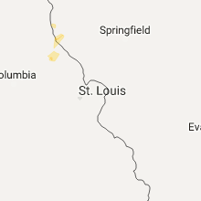
Hail Map for Thursday, July 6, 2017

Number of Impacted Households on 7/6/2017
0
Impacted by 1" or Larger Hail
0
Impacted by 1.75" or Larger Hail
0
Impacted by 2.5" or Larger Hail
Square Miles of Populated Area Impacted on 7/6/2017
0
Impacted by 1" or Larger Hail
0
Impacted by 1.75" or Larger Hail
0
Impacted by 2.5" or Larger Hail


Cities Most Affected by Hail Storms of 7/6/2017
| Hail Size | Demographics of Zip Codes Affected | ||||||
|---|---|---|---|---|---|---|---|
| City | Count | Average | Largest | Pop Density | House Value | Income | Age |
| Trempealeau, WI | 5 | 2.50 | 3.00 | 60 | $94k | $42.0k | 41.9 |
| Galesville, WI | 1 | 2.50 | 2.50 | 45 | $92k | $40.9k | 42.5 |
| Hayward, WI | 1 | 2.00 | 2.00 | 28 | $100k | $33.5k | 45.3 |
| Cochrane, WI | 1 | 1.75 | 1.75 | 34 | $85k | $38.4k | 47.1 |
| Fountain City, WI | 1 | 1.75 | 1.75 | 21 | $87k | $41.2k | 43.8 |
| La Crosse, WI | 1 | 1.75 | 1.75 | 624 | $94k | $34.8k | 30.3 |
Hail and Wind Damage Spotted on 7/6/2017
Filter by Report Type:Hail ReportsWind Reports
States Impacted
Michigan, Alabama, Georgia, Tennessee, North Carolina, South Carolina, Florida, Maine, Virginia, Kentucky, Colorado, Nevada, Louisiana, Wisconsin, Montana, Kansas, Nebraska, OhioMichigan
| Local Time | Report Details |
|---|---|
| 7:55 AM CDT | Tree down on roa in menominee county MI, 68.2 miles SSW of Marquette, MI |
| 7:55 AM CDT | Tree down on roa in menominee county MI, 71 miles S of Marquette, MI |
| 1:00 PM EDT | Estimated time of tree damage from radar observation. observed large uprooted maple and birch trees along camp 7 road just to the south of m123. the largest maple tree in luce county MI, 48.3 miles W of Sault Sainte Marie, MI |
| 2:15 PM EDT | 2 reports relayed via facebook of 5 inch and 6 inch limbs snapped. also a few shingles blown off roo in chippewa county MI, 1.2 miles SW of Sault Sainte Marie, MI |
| 5:45 PM EDT | Reported trees on power lines. time estimate in crawford county MI, 42.3 miles E of Traverse City, MI |
| 5:50 PM EDT | Reports of power lines down. time estimate in roscommon county MI, 50.9 miles ESE of Traverse City, MI |
| 5:51 PM EDT | Reports of power lines dow in roscommon county MI, 49.8 miles ESE of Traverse City, MI |
| 5:51 PM EDT | Several trees and limbs down along the southwest side of higgins lak in roscommon county MI, 49.8 miles ESE of Traverse City, MI |
| 5:55 PM EDT | Report of tree and power line down on car. time estimate in ogemaw county MI, 66.1 miles SSW of Alpena, MI |
| 5:59 PM EDT | Tree down in 200 block of shirley lane. time estimate in roscommon county MI, 52.5 miles ESE of Traverse City, MI |
| 6:20 PM EDT | Power lines down on the south side of clear lak in ogemaw county MI, 61.8 miles SW of Alpena, MI |
| 6:20 PM EDT | Widespread trees down reported across portions of ogemaw county. relayed from ogemaw county law enforcemen in ogemaw county MI, 61.7 miles SW of Alpena, MI |
| 6:46 PM EDT | Tree uprooted. report relayed via social media. time estimate in ogemaw county MI, 52 miles SSW of Alpena, MI |
| 7:02 PM EDT | Several trees down near sage lak in ogemaw county MI, 54.6 miles SSW of Alpena, MI |
| 8:45 PM EDT | Four to five medium to large trees were down along m95 near the floodwood r in marquette county MI, 35.1 miles SW of Marquette, MI |
| 8:55 PM EDT | Quarter sized hail reported near Houghton Lake, MI, 49.2 miles SE of Traverse City, MI, report of quarter sized hail. relayed from 9 & 10 news broadcast meteorologist. |
| 8:50 PM CDT | Delta county dispatch reports that a tree has fallen on a van on french town r in menominee county MI, 59.7 miles S of Marquette, MI |
| 9:10 PM CDT | Tree snapped and uprooted. one of the large trees was 2 to 3 foot in diamete in menominee county MI, 67.6 miles NNE of Green Bay, WI |
| 9:17 PM CDT | Trees snapped or uprooted. large tree 2-3 foot in diameter uproote in menominee county MI, 67.6 miles NNE of Green Bay, WI |
| 2:36 AM EDT | Thunderstorms winds broke a healthy maple tree off its trunk. the tree was healthy. also power lines down at porter rd. and lake harbor roa in muskegon county MI, 32.9 miles WNW of Grand Rapids, MI |
| 2:40 AM EDT | Muskegon gler in muskegon county MI, 38 miles WNW of Grand Rapids, MI |
| 2:50 AM EDT | Multiple trees down in the area... some on homes and some over roads. power lines are also dow in ottawa county MI, 28.5 miles WNW of Grand Rapids, MI |
| 2:50 AM EDT | *** 1 fatal *** large tree fell on a home. 72 year old man was killed. time estimate in ottawa county MI, 29.4 miles WNW of Grand Rapids, MI |
| 2:50 AM EDT | Gust to 80 mph at 247 am... and gust to 88 at 250 am. may have reached 103 mph before station stopped reporting. south highland association personal weather station kmi in ottawa county MI, 29.2 miles W of Grand Rapids, MI |
| 2:52 AM EDT | Mesonet station xghl... 1 w grand have in lmz846 county MI, 30.5 miles WNW of Grand Rapids, MI |
| 2:53 AM EDT | Trees reported to have been blown down by thunderstorm winds onto homes in grand have in ottawa county MI, 28.5 miles WNW of Grand Rapids, MI |
| 3:10 AM EDT | Trees and power lines down... some roads are blocke in ottawa county MI, 12.1 miles SW of Grand Rapids, MI |
| 3:15 AM EDT | Reported at grand valley state univ-allendal in ottawa county MI, 11.1 miles W of Grand Rapids, MI |
| 3:15 AM EDT | 3 large trees are blocking the road on kenowa avenue... south of 36th street. kenowa avenue is closed off in that sectio in ottawa county MI, 7.2 miles SW of Grand Rapids, MI |
| 3:18 AM EDT | Trees and power lines have been blown down around the rivertown crossings mall. some roads are blocked. reported at rivertown parkway and wilson avenue... grandville mi in kent county MI, 7.5 miles SW of Grand Rapids, MI |
| 3:24 AM EDT | Reported at memorial feild... grand rapids m in kent county MI, 3.3 miles ESE of Grand Rapids, MI |
| 3:26 AM EDT | Pea size but no trees reported dow in kent county MI, 1.2 miles SSW of Grand Rapids, MI |
| 3:29 AM EDT | Reported at colindale grand rapid in kent county MI, 3.6 miles WNW of Grand Rapids, MI |
| 3:29 AM EDT | Trees and power lines dow in ottawa county MI, 14.2 miles W of Grand Rapids, MI |
| 3:31 AM EDT | Asos station grr... gerald r ford int in kent county MI, 8.5 miles SE of Grand Rapids, MI |
| 3:40 AM EDT | Trees and power lines down across kent county. some trees on home in kent county MI, 14.1 miles SE of Grand Rapids, MI |
| 4:28 AM EDT | Strong thunderstorm winds have blown down several trees on the south side of holt near waverly roa in eaton county MI, 53 miles WSW of Flint, MI |
Alabama
| Local Time | Report Details |
|---|---|
| 11:48 AM CDT | Several trees reported down along highway 75 from fyffe to rainsvill in dekalb county AL, 53.1 miles SW of Chattanooga, TN |
| 11:58 AM CDT | A few trees and power lines down between fort payne and fyffe along hwy 75 and cr 86 in dekalb county AL, 53.1 miles SW of Chattanooga, TN |
| 12:10 PM CDT | Multiple trees down near the intersection of cr 255 and cr 256... between fort payne and adamsbur in dekalb county AL, 48.9 miles SSW of Chattanooga, TN |
| 12:48 PM CDT | A tree was blown down blocking the road on the 2000 block of cr 21 in cullman county AL, 38.8 miles N of Birmingham, AL |
| 2:43 PM CDT | Trees were blown down on cr 3 at this locatio in jackson county AL, 54.5 miles WSW of Chattanooga, TN |
| 3:18 PM CDT | Trees down on county road 287 near al 117. also one oak tree uprooted onto a house. time estimated from rada in jackson county AL, 32.3 miles WSW of Chattanooga, TN |
| 3:30 PM CDT | Tree down across al 277 off us 72. time estimated from rada in jackson county AL, 24.4 miles WSW of Chattanooga, TN |
| 3:54 PM CDT | Trees down on davis street in glenco in etowah county AL, 59.3 miles ENE of Birmingham, AL |
| 4:00 PM CDT | Trees down in ohatchee... including one tree on a structure on thompson rd. time based on rada in calhoun county AL, 49 miles ENE of Birmingham, AL |
| 4:24 PM CDT | Trees and power lines down in piedmont. time based on rada in calhoun county AL, 71.8 miles W of Atlanta, GA |
| 4:33 PM CDT | Trees reported down on al hwy 102 at the fayette/walker co line via social medi in fayette county AL, 45.4 miles WNW of Birmingham, AL |
| 4:40 PM CDT | Multiple trees down in pell city... including roof damage reported on allen road... where half of the roof was blown off of an unknown building. time estimated by radar in st. clair county AL, 31 miles E of Birmingham, AL |
| 5:27 PM CDT | Trees down at the intersection of mcintosh road and mary drive. time based on rada in talladega county AL, 56.7 miles E of Birmingham, AL |
| 5:30 PM CDT | Power lines down at martin luther king drive and washington street in hobson city. time based on rada in calhoun county AL, 56.5 miles E of Birmingham, AL |
| 5:30 PM CDT | Trees and power lines reported down in oxford on luttrell stree in calhoun county AL, 57 miles E of Birmingham, AL |
| 5:30 PM CDT | Tree down on diane drive on the northeast side of oxfor in calhoun county AL, 58.8 miles E of Birmingham, AL |
Georgia
| Local Time | Report Details |
|---|---|
| 1:13 PM EDT | Utility wires reported down at 1573 marble quarry r in cherokee county GA, 29.9 miles NNW of Atlanta, GA |
| 1:39 PM EDT | Tree reported down on a house at 394 burns l in cherokee county GA, 33.9 miles N of Atlanta, GA |
| 2:00 PM EDT | Power lines reported down at the intersection of keith bridge rd and parks r in forsyth county GA, 40.7 miles NNE of Atlanta, GA |
| 2:24 PM EDT | Wind gust of 60 mph reported by gainesville asos at 1824 in hall county GA, 48.3 miles NE of Atlanta, GA |
| 3:05 PM EDT | Tree reported down near 200 block of vaughn r in banks county GA, 58.7 miles SW of Greenville, SC |
| 3:08 PM EDT | Tree and power lines reported down at 120 snow mountain lan in gilmer county GA, 52.9 miles ESE of Chattanooga, TN |
| 3:25 PM EDT | Franklin dispatch reported 2 trees down and power lines down in franklin spring in franklin county GA, 48.7 miles SW of Greenville, SC |
| 3:31 PM EDT | 911 call center reported a tree down on river bend circle in roysto in franklin county GA, 50.9 miles SW of Greenville, SC |
| 3:36 PM EDT | Tree down blocking the road on henson way at the intersection of union hill r in cherokee county GA, 33.2 miles N of Atlanta, GA |
| 3:38 PM EDT | Multiple trees down in a 100 yard swath between cambridge way and red top mountain r in bartow county GA, 33.8 miles NW of Atlanta, GA |
| 3:43 PM EDT | Multiple trees down and at least one house was damaged along sam nelson rd... between nelson trl and rampley tr in cherokee county GA, 37.8 miles NNW of Atlanta, GA |
| 3:43 PM EDT | Tree reported down across the road at the intersection of sam nelson rd and rampley trl in cherokee county GA, 37 miles NNW of Atlanta, GA |
| 3:48 PM EDT | Tree reported down on a house at 1311 reinhardt college parkwa in cherokee county GA, 35.7 miles N of Atlanta, GA |
| 3:48 PM EDT | Tree down on power lines at the intersection of shoal creek rd and whispering woods d in cherokee county GA, 35.1 miles N of Atlanta, GA |
| 3:50 PM EDT | Several trees down on a residence at 6714 bells ferry r in cherokee county GA, 29.3 miles NNW of Atlanta, GA |
| 4:07 PM EDT | Tree reported down on power lines at the intersection of wyatt rd and smithwick rd in cherokee county GA, 33.6 miles N of Atlanta, GA |
| 4:52 PM EDT | Reported a couple of trees down along... dot barrels blown all over roadway and traffic lights out. these occurred along furys ferry road... point comfort road... gibbs in columbia county GA, 8.2 miles NW of Augusta, GA |
| 4:56 PM EDT | Tree reported down at the intersection of stephens salem rd and hugh culbreth r in oglethorpe county GA, 68.3 miles WNW of Augusta, GA |
| 5:05 PM EDT | Tree reported down along frank matthews r in oglethorpe county GA, 67.5 miles WNW of Augusta, GA |
| 5:42 PM EDT | Tree down along danburg rd near the intersection with bradford r in wilkes county GA, 47.3 miles NW of Augusta, GA |
| 5:53 PM EDT | Reported 10 power poles snapped and lines down near the intersection of graball road and highway 7 in lincoln county GA, 46.7 miles NW of Augusta, GA |
| 5:54 PM EDT | Tree down in the 400 block of monroe mill r in haralson county GA, 51.6 miles W of Atlanta, GA |
| 6:03 PM EDT | Tree reported down on sam hutchens rd in cedartow in polk county GA, 55.1 miles WNW of Atlanta, GA |
| 6:11 PM EDT | Several trees reported down in the 1000 block of 5 points rd in haralson county GA, 44.6 miles W of Atlanta, GA |
| 6:15 PM EDT | Tree down near the intersection of hightower falls rd and antioch r in polk county GA, 46.4 miles WNW of Atlanta, GA |
| 6:20 PM EDT | Tree reported down near the intersection of floyd rd and mountain view r in haralson county GA, 44.7 miles WNW of Atlanta, GA |
Tennessee
| Local Time | Report Details |
|---|---|
| 1:55 PM EDT | Tree down on neyland driv in knox county TN, 1.8 miles WNW of Knoxville, TN |
| 2:50 PM EDT | 3 trees down on hopewell road. time estimated by rada in claiborne county TN, 48.1 miles NNE of Knoxville, TN |
| 4:37 PM CDT | Trees down on swan ridge road in clay county TN, 79.7 miles ENE of Nashville, TN |
| 5:06 PM CDT | Tree down on cross avenue in livingston in overton county TN, 81.9 miles ENE of Nashville, TN |
| 5:29 PM CDT | Tree down on wilder hwy southeast of livingston in overton county TN, 77.8 miles WNW of Knoxville, TN |
| 7:09 PM EDT | High winds reported with several trees dow in campbell county TN, 30.6 miles NNW of Knoxville, TN |
| 6:22 PM CDT | Tree down on 7th street and north jefferson avenue in cookeville in putnam county TN, 70.9 miles E of Nashville, TN |
| 7:35 PM EDT | Several trees down across northern union count in union county TN, 25.6 miles NNE of Knoxville, TN |
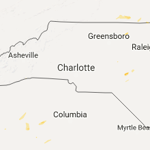
North Carolina
| Local Time | Report Details |
|---|---|
| 2:30 PM EDT | Trees down. flag pole snapped. outdoor furniture blown aroun in pender county NC, 20.3 miles NE of Wilmington, NC |
| 4:45 PM EDT | Emergency mngr reported trees down on power lines on wildlife rd at hwy 12 in mcdowell county NC, 61.8 miles SSE of Bristol, TN |
| 4:49 PM EDT | Emergency mngr reported us 221 s shut down due to trees and power lines down in the glenwood communit in mcdowell county NC, 65.6 miles NNE of Greenville, SC |
| 4:50 PM EDT | Social media reported trees down blocking i-40 in valdese in burke county NC, 53.7 miles NW of Charlotte, NC |
| 5:15 PM EDT | Social media reported area of roof torn off a town home off reese blvd west. time estimated from rada in mecklenburg county NC, 12.3 miles N of Charlotte, NC |
| 5:16 PM EDT | Fire dept/rescue reported a tree down on power lines on beatties ford rd. time estimated from rada in mecklenburg county NC, 4.2 miles NNW of Charlotte, NC |
| 5:20 PM EDT | Fire dept/rescue reported a tree down on reed blvd. time estimated from rada in mecklenburg county NC, 5.4 miles WNW of Charlotte, NC |
| 5:20 PM EDT | Fire dept/rescue reported a tree down on northcrest dr. time estimated from rada in mecklenburg county NC, 3.9 miles NNE of Charlotte, NC |
| 5:20 PM EDT | Amateur radio reported tree down on reese blvd at reese blvd wes in mecklenburg county NC, 12.3 miles N of Charlotte, NC |
| 5:20 PM EDT | Trained spotter reported a tree down across powerlines on mt. holly-huntersville rd and hwy 115. time estimated from rada in mecklenburg county NC, 10.2 miles N of Charlotte, NC |
| 5:30 PM EDT | Amateur radio reported a tree down on long common parkway at leferts house place. time estimated from rada in mecklenburg county NC, 11.2 miles NNE of Charlotte, NC |
| 5:31 PM EDT | Social media reported trees down on bud henderson rd off of beatties ford rd. time estimated from rada in mecklenburg county NC, 13.1 miles NNW of Charlotte, NC |
| 8:11 PM EDT | Public estimated peak winds of 60-65 mph in the buffalo lakes area. several small trees and numerous branches were blown dow in harnett county NC, 40.8 miles SSW of Raleigh, NC |
| 8:23 PM EDT | Storm damage reported in pitt county NC, 72.7 miles E of Raleigh, NC |
| 9:16 PM EDT | One tree down at the 5000 block of goldsboro r in cumberland county NC, 46.1 miles S of Raleigh, NC |
| 9:21 PM EDT | One tree down near the intersection of goldsboro rd and wade-stedman r in cumberland county NC, 45.3 miles S of Raleigh, NC |
| 9:36 PM EDT | Gust was associated with the outflow boundary from the storm in beaufort county NC, 86.4 miles SSW of Virginia Beach, VA |
| 9:50 PM EDT | Emergency manager reported multiple trees down near the intersection of railroad bed road and highway 9 in washington county NC, 77.5 miles SSW of Virginia Beach, VA |
South Carolina
| Local Time | Report Details |
|---|---|
| 3:40 PM EDT | Social media reported a tree down on mt. airy church rd in easley. time estimated from rada in anderson county SC, 6.3 miles SE of Greenville, SC |
| 3:40 PM EDT | 911 call center reported numerous trees down in southern easle in anderson county SC, 4.9 miles SE of Greenville, SC |
| 3:44 PM EDT | 911 call center reported numerous trees down in the town of powdersvill in anderson county SC, 5.6 miles ESE of Greenville, SC |
| 3:48 PM EDT | Social media reported a large limb down on powerlines at the 185-85 interchange in greenville county in greenville county SC, 9.5 miles ESE of Greenville, SC |
| 5:06 PM EDT | Reported a tree down on cherry tree lan in edgefield county SC, 9.4 miles NNW of Augusta, GA |
| 5:26 PM EDT | 2 trees down at powderhouse rd and woodwardia glen in se aike in aiken county SC, 16.1 miles E of Augusta, GA |
| 6:00 PM EDT | Reported tree downed a power line and is blocking jalapa road near i-2 in newberry county SC, 61 miles ESE of Greenville, SC |
| 6:25 PM EDT | Reported several trees down across the northern portion of the county. one area was near old chappells ferry road and long cane roa in edgefield county SC, 29 miles NNE of Augusta, GA |
| 6:39 PM EDT | Tree down on power lines on bickley road across from ballentine elementary schoo in richland county SC, 61.7 miles NE of Augusta, GA |
| 6:55 PM EDT | Tree down near the intersection of highway 269 and landis road. time estimated based on rada in fairfield county SC, 70.2 miles SSW of Charlotte, NC |
| 7:04 PM EDT | Reported trees down along i-77 near the richland county and fairfield county lin in fairfield county SC, 68.4 miles S of Charlotte, NC |
| 7:04 PM EDT | Tree in roadway at slab landing road and woodhaven street. reported by sc highway patro in orangeburg county SC, 54.4 miles E of Augusta, GA |
| 7:06 PM EDT | Public report via twitter of trees down/uprooted. tree uprooted and down on hous in lexington county SC, 48.5 miles NE of Augusta, GA |
| 7:17 PM EDT | Pictures from the public on social media indicate at least one tree trunk snapped as well as numerous large tree limbs on k avenue. time estimated based on rada in lexington county SC, 62.5 miles NE of Augusta, GA |
| 7:29 PM EDT | Reported a tree down along wateree dam roa in kershaw county SC, 63.3 miles S of Charlotte, NC |
| 8:08 PM EDT | Reported trees down along black river road. a tree blocking crestview road near black river road. a power line was down near dorsey driv in sumter county SC, 62.9 miles NNW of Charleston, SC |
| 8:18 PM EDT | Reported a tree down on biddle road near u.s. highway 1 in sumter county SC, 62.8 miles NNW of Charleston, SC |
| 8:19 PM EDT | Reported a tree down along sumter highway... u.s. highway 1 in lee county SC, 63.4 miles NNW of Charleston, SC |
| 8:22 PM EDT | Reported trees and power lines south of bishopville on wisacky highwa in lee county SC, 66.5 miles N of Charleston, SC |
| 8:49 PM EDT | Reported a tree down along the southbound lane of i-95 near exit 14 in sumter county SC, 57.5 miles N of Charleston, SC |
Florida
| Local Time | Report Details |
|---|---|
| 3:45 PM EDT | A large tree was blown down at the intersection of sw 102nd street road and sw 214 cour in marion county FL, 76.9 miles WNW of Orlando, FL |
| 5:30 PM EDT | 13 mobile homes sustained wind damage in the river haven mobile home park. no injuries were foun in charlotte county FL, 52.9 miles NNW of Naples, FL |
| 9:00 PM EDT | Albert whitted airport reported a wind gust of 58 mp in pinellas county FL, 18.5 miles N of Bradenton, FL |
Maine
| Local Time | Report Details |
|---|---|
| 4:06 PM EDT | 2 large spruce trees down on the russell roa in aroostook county ME, 10.6 miles SE of Caribou, ME |
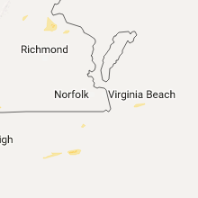
Virginia
| Local Time | Report Details |
|---|---|
| 4:33 PM EDT | Pine tree blown down has road blocke in pittsylvania county VA, 41 miles SE of Roanoke, VA |
| 4:40 PM EDT | One tree down across bearskin roa in pittsylvania county VA, 43.1 miles SE of Roanoke, VA |
| 4:41 PM EDT | Power lines down on military driv in pittsylvania county VA, 42.7 miles SE of Roanoke, VA |
| 4:44 PM EDT | One tree down across dry fork roa in pittsylvania county VA, 45.7 miles SE of Roanoke, VA |
| 4:51 PM EDT | Power lines down along u.s. 2 in pittsylvania county VA, 47.5 miles SE of Roanoke, VA |
| 5:07 PM EDT | One tree down across reeves mill roa in pittsylvania county VA, 56.9 miles SE of Roanoke, VA |
| 5:15 PM EDT | Thunderstorm winds downed a tree near the intersection of deer ridge trail and oak level road just west of the city of south bosto in halifax county VA, 59.6 miles SE of Roanoke, VA |
| 5:32 PM EDT | Thunderstorm winds downed a tree near the intersection of deer ridge trail and oak level road just west of the city of south bosto in halifax county VA, 59.6 miles SE of Roanoke, VA |
| 5:36 PM EDT | Thunderstorm winds downed a tree near the intersection of philpott road and maplewood driv in halifax county VA, 63.6 miles NNW of Raleigh, NC |
| 5:37 PM EDT | Thunderstorm winds downed at least four healthy trees within the city of south boston. time estimated via rada in halifax county VA, 64.7 miles NNW of Raleigh, NC |
| 5:37 PM EDT | A tree was blown down near the intersection of briggs street and n main stree in halifax county VA, 66 miles NNW of Raleigh, NC |
| 5:45 PM EDT | A tree was blown down along timberlake driv in campbell county VA, 37.1 miles E of Roanoke, VA |
| 5:47 PM EDT | Tree blown on a car along edgewood avenu in city of lynchburg county VA, 42.4 miles E of Roanoke, VA |
| 5:54 PM EDT | A tree was blown down along camp hydaway roa in campbell county VA, 43.8 miles E of Roanoke, VA |
| 5:58 PM EDT | A tree was blown down along beaver creek crossin in campbell county VA, 45.9 miles E of Roanoke, VA |
| 6:08 PM EDT | A tree was blown down along toll gate roa in campbell county VA, 52.5 miles E of Roanoke, VA |
| 6:19 PM EDT | Three tree linbs down at rapidan rd and locust dale r in culpeper county VA, 60.1 miles NNW of Richmond, VA |
| 6:40 PM EDT | A tree dow in mecklenburg county VA, 61.9 miles NNE of Raleigh, NC |
| 6:42 PM EDT | 5 to 10 trees down on route 20 at sunflower ln in orange county VA, 55 miles NNW of Richmond, VA |
| 6:44 PM EDT | Tree down at st. just rd and mine run r in orange county VA, 53.5 miles NNW of Richmond, VA |
| 6:44 PM EDT | Tree down on route 20 between grasty gold mine rd and burr hill r in orange county VA, 55.5 miles NNW of Richmond, VA |
| 7:15 PM EDT | Tree down on robert e lee drive in spotsylvania county VA, 48 miles N of Richmond, VA |
| 7:30 PM EDT | Several trees dow in lee county VA, 48.7 miles WNW of Bristol, TN |
| 7:50 PM EDT | Trees down in port royal are in caroline county VA, 52.4 miles NNE of Richmond, VA |
| 8:00 PM EDT | Trees down in the fort ap hill are in caroline county VA, 46.7 miles NNE of Richmond, VA |
| 8:25 PM EDT | Tree down on us rt 17 between hunters hill road and o'neil road. in essex county VA, 50.4 miles NE of Richmond, VA |
Kentucky
| Local Time | Report Details |
|---|---|
| 5:15 PM EDT | Quarter sized hail reported near Somerset, KY, 56.8 miles SW of Irvine, KY, quarter size hail reported south of somerset. also a funnel cloud was sighted. |
| 5:23 PM EDT | Trees down across eads street in monticello in wayne county KY, 76.4 miles SW of Irvine, KY |
| 5:24 PM EDT | A roof was blown off of a trailer on jacksboro road. the time of the event is estimated from radar dat in pulaski county KY, 60.5 miles SW of Irvine, KY |
| 5:48 PM EDT | Damage to a barn roof and one tree was split in hal in laurel county KY, 49.5 miles SSW of Irvine, KY |
| 5:52 PM EDT | A large tree was blown down onto the road at the intersection of ky hwy 638 and ky hwy 57 in laurel county KY, 32.4 miles S of Irvine, KY |
| 5:58 PM EDT | A tree was repoted to have been blown down in the knox county portion of corbin. the time of the event is estimated from radar dat in knox county KY, 52.7 miles S of Irvine, KY |
| 5:59 PM EDT | Power poles down along harris karr road in laurel county KY, 39.7 miles S of Irvine, KY |
| 6:08 PM EDT | A tree was reported to have been blown down in the stearns vicinity but closer to yamacraw. the time of the event is estimated from radar dat in mccreary county KY, 61.2 miles NNW of Knoxville, TN |
| 6:16 PM EDT | A tree was reported to have been blown down on ky 92 in the pine knot area. the time of the event is estimated from radar dat in mccreary county KY, 56.3 miles NNW of Knoxville, TN |
| 6:28 PM EDT | A tree was reported to have been blown down. the time of the evet is esimated from radar dat in knox county KY, 59.9 miles N of Knoxville, TN |
| 6:32 PM EDT | A tree was blown down onto ky highway 66. the time of the event is estimated from radar dat in clay county KY, 52.9 miles SSE of Irvine, KY |
| 6:42 PM EDT | A tree was down near the intersection of us highway 421 and middle fork road. the time of the event is estimated from radar dat in leslie county KY, 55.4 miles SE of Irvine, KY |
| 6:44 PM EDT | A tree was blown down onto us highway 421. the event time is estimated from radar dat in leslie county KY, 53.4 miles SE of Irvine, KY |
| 6:45 PM EDT | Telephone/tv lines and/or pole down along ky 476 near godsey hollow roa in perry county KY, 52.3 miles ESE of Irvine, KY |
| 6:45 PM EDT | Telephone/tv lines and/or pole down along ky 476 near godsey hollow roa in perry county KY, 52.3 miles ESE of Irvine, KY |
| 7:06 PM EDT | A tree was repoted to have been blown down onto powerlines. the time of the event is estimated from radar dat in harlan county KY, 57.4 miles WNW of Bristol, TN |
| 10:55 PM EDT | Trees uprooted from high winds in whitley county KY, 55.2 miles N of Knoxville, TN |
Colorado
| Local Time | Report Details |
|---|---|
| 3:35 PM MDT | No damage. lots of blowing dus in weld county CO, 60.1 miles SE of Laramie, WY |
Nevada
| Local Time | Report Details |
|---|---|
| 2:42 PM PDT | Mesonet station spmn2... spruce mountain raw in elko county NV, 57.3 miles ESE of Elko, NV |
| 5:35 PM PDT | Reese river valley dri mesonet sit in lander county NV, 122.5 miles S of Winnemucca, NV |
| 5:42 PM PDT | Storm damage reported in clark county NV, 42.1 miles NW of Las Vegas, NV |
| 7:46 PM PDT | Storm damage reported in clark county NV, 42.1 miles NW of Las Vegas, NV |
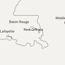
Louisiana
| Local Time | Report Details |
|---|---|
| 4:50 PM CDT | Tree dow in caddo county LA, 6.8 miles WNW of Shreveport, LA |
| 4:50 PM CDT | Tree dow in caddo county LA, 9.7 miles WNW of Shreveport, LA |
| 4:50 PM CDT | Tree dow in caddo county LA, 14.1 miles WNW of Shreveport, LA |
| 4:54 PM CDT | Tree dow in caddo county LA, 13.7 miles WSW of Shreveport, LA |
| 4:54 PM CDT | Tree dow in caddo county LA, 14.5 miles WSW of Shreveport, LA |
| 4:55 PM CDT | Tree dow in caddo county LA, 11.9 miles SW of Shreveport, LA |
| 4:55 PM CDT | Tree dow in caddo county LA, 12.4 miles SW of Shreveport, LA |
| 4:55 PM CDT | Power lines dow in caddo county LA, 8.8 miles SW of Shreveport, LA |
| 4:55 PM CDT | Tree dow in caddo county LA, 3.7 miles NNW of Shreveport, LA |
| 5:04 PM CDT | Tree dow in caddo county LA, 6.7 miles WSW of Shreveport, LA |
| 5:09 PM CDT | Tree dow in caddo county LA, 2.6 miles SW of Shreveport, LA |
| 5:10 PM CDT | Tree dow in caddo county LA, 3.1 miles SW of Shreveport, LA |
| 5:10 PM CDT | Powerlines dow in caddo county LA, 5.1 miles S of Shreveport, LA |
| 5:10 PM CDT | Tree dow in caddo county LA, 2.7 miles WSW of Shreveport, LA |
| 5:12 PM CDT | Tree dow in caddo county LA, 2.5 miles SSW of Shreveport, LA |
| 5:15 PM CDT | Tree dow in caddo county LA, 4.5 miles S of Shreveport, LA |
| 5:15 PM CDT | Tree dow in caddo county LA, 6.8 miles SSW of Shreveport, LA |
| 5:20 PM CDT | Trees dow in caddo county LA, 6.9 miles SSE of Shreveport, LA |
| 5:20 PM CDT | Tree dow in caddo county LA, 7.1 miles SSE of Shreveport, LA |
| 5:50 PM CDT | Trees and power lines dow in de soto county LA, 39.7 miles SSW of Shreveport, LA |
| 6:05 PM CDT | Tree down by ac steere elementary schoo in caddo county LA, 4.1 miles SSE of Shreveport, LA |
| 6:10 PM CDT | Trees and power lines dow in de soto county LA, 29.5 miles S of Shreveport, LA |
Wisconsin
| Local Time | Report Details |
|---|---|
| 5:30 PM CDT | Ping Pong Ball sized hail reported near Waupaca, WI, 53.3 miles WSW of Green Bay, WI, submitted via internet. |
| 6:30 PM CDT | Quarter sized hail reported near Drummond, WI, 53 miles SE of Duluth, MN, report relayed via mping. |
| 6:36 PM CDT | Quarter sized hail reported near Ashland, WI, 60.2 miles ESE of Duluth, MN, relayed by local media to nws office. |
| 6:45 PM CDT | Pictures sent into the office of several trees downed by thunderstorms. one of the trees was struck by lightning with another having roots exposed. property damage to w in sawyer county WI, 61.8 miles SSE of Duluth, MN |
| 6:51 PM CDT | Golf Ball sized hail reported near Cochrane, WI, 41.1 miles NW of La Crosse, WI, law enforcement reported golf ball size hail near the city of cochrane |
| 7:08 PM CDT | Hen Egg sized hail reported near Hayward, WI, 60.3 miles SSE of Duluth, MN, time estimated from radar. photographed sent into office via social media. |
| 7:18 PM CDT | Golf Ball sized hail reported near Fountain City, WI, 30.5 miles NW of La Crosse, WI, trained spotter reported golf ball size hail. |
| 7:21 PM CDT | Quarter sized hail reported near Winter, WI, 80.8 miles SE of Duluth, MN, report relayed via mping. |
| 7:33 PM CDT | Half Dollar sized hail reported near Nekoosa, WI, 75.2 miles ENE of La Crosse, WI |
| 7:45 PM CDT | Some dead branches blew off tree in florence county WI, 56.3 miles SW of Marquette, MI |
| 7:45 PM CDT | Hen Egg sized hail reported near Trempealeau, WI, 21.9 miles NW of La Crosse, WI |
| 7:48 PM CDT | Tennis Ball sized hail reported near Galesville, WI, 20.3 miles NNW of La Crosse, WI, broadcast media via social media. |
| 7:48 PM CDT | Ping Pong Ball sized hail reported near Trempealeau, WI, 18.8 miles NW of La Crosse, WI |
| 7:53 PM CDT | Hen Egg sized hail reported near Trempealeau, WI, 16.5 miles NW of La Crosse, WI, broadcast media via social media. |
| 7:53 PM CDT | Tea Cup sized hail reported near Trempealeau, WI, 16.9 miles NNW of La Crosse, WI, trained spotter reports three and a half inch size hail at trailer park in trempealeau and broken windows. |
| 8:00 PM CDT | Ping Pong Ball sized hail reported near Hancock, WI, 70.9 miles N of Madison, WI, intersection of county highways b and c |
| 8:14 PM CDT | Baseball sized hail reported near Trempealeau, WI, 16.5 miles NW of La Crosse, WI, reported in the city of trempealeau. |
| 8:30 PM CDT | Ping Pong Ball sized hail reported near Glen Flora, WI, 68.4 miles W of Rhinelander, WI, reported at highway 8 and hiway 73... tony... wi. |
| 8:35 PM CDT | Tree branches down at stoker rd and highway in rusk county WI, 70.9 miles W of Rhinelander, WI |
| 8:35 PM CDT | Ping Pong Ball sized hail reported near Onalaska, WI, 5.6 miles NNE of La Crosse, WI |
| 8:38 PM CDT | Quarter sized hail reported near Onalaska, WI, 5.9 miles NE of La Crosse, WI |
| 8:48 PM CDT | Baseball sized hail reported near Trempealeau, WI, 18.8 miles NW of La Crosse, WI, via social media baseball size hail with broken windows near perot state park. |
| 8:48 PM CDT | Golf Ball sized hail reported near La Crosse, WI, 7.9 miles ESE of La Crosse, WI |
| 9:25 PM CDT | Quarter sized hail reported near Oxford, WI, 55.7 miles N of Madison, WI, one inch diameter hail was accumulating to 1 to 2 inch depth. has been hailing for 5-6 minutes. |
| 9:29 PM CDT | Quarter sized hail reported near Westfield, WI, 57.2 miles N of Madison, WI, delayed report. quarter size hail in lawrence. also multiple tree branches down. time estimated from radar. |
| 9:37 PM CDT | Trees and power lines down in egg harbor. time estimated from radar. other sporatic trees and power lines down throughout the count in door county WI, 51.1 miles NE of Green Bay, WI |
| 9:56 PM CDT | Mping report of 3 inch tree limbs broken as well as power poles broken. time estimated from rada in adams county WI, 50.2 miles NNW of Madison, WI |
| 10:25 PM CDT | Trees down near portag in columbia county WI, 33.2 miles N of Madison, WI |
| 10:55 PM CDT | Multiple trees down in beaver da in dodge county WI, 38.9 miles NE of Madison, WI |
| 11:15 PM CDT | Estimated wind gust to 60 mph. tree limbs and branches down. power outages citywidy... approx. 3400 customers affecte in outagamie county WI, 15.8 miles W of Green Bay, WI |
| 11:33 PM CDT | Quarter sized hail reported near Madison, WI, 5.2 miles NE of Madison, WI, 1 inch diameter hail near dane co. airport. |
| 11:43 PM CDT | Tree down on a house at intersection of woodlawn drive and glenview drive. several trees down in this are in dane county WI, 3.5 miles ESE of Madison, WI |
| 12:16 AM CDT | Quarter sized hail reported near Palmyra, WI, 42.5 miles ESE of Madison, WI, estimated 50 mph wind with 1" diameter hail. |
| 12:25 AM CDT | Trees down and power outages in waterfor in racine county WI, 62.8 miles ESE of Madison, WI |
Montana
| Local Time | Report Details |
|---|---|
| 5:13 PM MDT | Storm damage reported in yellowstone county MT, 2.8 miles NW of Billings, MT |
| 5:15 PM MDT | Storm damage reported in musselshell county MT, 47.4 miles N of Billings, MT |
| 5:20 PM MDT | Storm damage reported in yellowstone county MT, 6.3 miles SE of Billings, MT |
| 5:25 PM MDT | Storm damage reported in yellowstone county MT, 2.8 miles NW of Billings, MT |
| 5:25 PM MDT | Tree branch on car. time estimate in yellowstone county MT, 1.7 miles W of Billings, MT |
| 5:27 PM MDT | Storm damage reported in yellowstone county MT, 3.9 miles NNE of Billings, MT |
| 5:30 PM MDT | Storm damage reported in musselshell county MT, 32.3 miles N of Billings, MT |
| 6:05 PM MDT | A metal barn destroyed. it was made of 2 by 4s and railroad ties. debris blown 70 feet away. event time/location estimate in lewis and clark county MT, 71.7 miles SSW of Great Falls, MT |
| 6:21 PM MDT | Storm damage reported in yellowstone county MT, 6.3 miles SE of Billings, MT |
Kansas
| Local Time | Report Details |
|---|---|
| 6:45 PM CDT | Storm spotter reported 60 mph wind gusts with blowing dust in cheyenne county KS, 35.2 miles NW of Colby, KS |
| 6:52 PM CDT | Bird city airport reported 64 mph wind gust and reduced visibility to one quarter mile due to blowing dus in cheyenne county KS, 35.5 miles NW of Colby, KS |
Nebraska
| Local Time | Report Details |
|---|---|
| 7:32 PM CDT | Measured on a hand held devic in furnas county NE, 66.8 miles SSE of North Platte, NE |
| 7:46 PM CDT | Storm damage reported in furnas county NE, 65.8 miles SSE of North Platte, NE |
| 10:02 PM MDT | Storm damage reported in dawes county NE, 75 miles NNE of Scottsbluff, NE |
Ohio
| Local Time | Report Details |
|---|---|
| 7:20 AM EDT | Crawford county 911 call center reported trees and wires down in the city of bucyru in crawford county OH, 57.8 miles N of Columbus, OH |
Connect with Interactive Hail Maps