

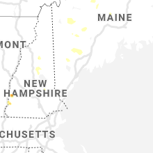
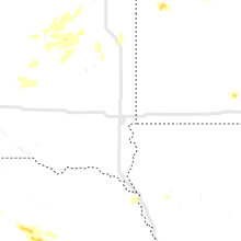
Hail Map for Wednesday, July 8, 2020

Number of Impacted Households on 7/8/2020
0
Impacted by 1" or Larger Hail
0
Impacted by 1.75" or Larger Hail
0
Impacted by 2.5" or Larger Hail
Square Miles of Populated Area Impacted on 7/8/2020
0
Impacted by 1" or Larger Hail
0
Impacted by 1.75" or Larger Hail
0
Impacted by 2.5" or Larger Hail


Cities Most Affected by Hail Storms of 7/8/2020
| Hail Size | Demographics of Zip Codes Affected | ||||||
|---|---|---|---|---|---|---|---|
| City | Count | Average | Largest | Pop Density | House Value | Income | Age |
| Thedford, NE | 2 | 2.13 | 2.50 | 0 | $39k | $31.7k | 46.4 |
| Park Rapids, MN | 2 | 2.00 | 2.00 | 28 | $95k | $33.5k | 47.2 |
| Nevis, MN | 2 | 2.00 | 2.00 | 22 | $124k | $37.3k | 52.1 |
| Ortonville, MN | 1 | 2.00 | 2.00 | 20 | $48k | $31.3k | 49.2 |
| Wilsonville, NE | 1 | 1.75 | 1.75 | 1 | $24k | $34.7k | 52.8 |
| Westmoreland, NH | 1 | 1.75 | 1.75 | 40 | $129k | $55.9k | 47.8 |
| Elsmere, NE | 1 | 1.75 | 1.75 | 0 | $113k | $28.8k | 45.5 |
| Carpenter, SD | 1 | 1.75 | 1.75 | 1 | $34k | $31.8k | 41.5 |
| Charlestown, NH | 1 | 1.75 | 1.75 | 90 | $83k | $38.5k | 44.0 |
| South Acworth, NH | 1 | 1.75 | 1.75 | 9 | $74k | $27.4k | 52.4 |
| Lake Nebagamon, WI | 1 | 1.75 | 1.75 | 21 | $107k | $46.9k | 46.4 |
| Motley, MN | 1 | 1.75 | 1.75 | 16 | $77k | $31.9k | 44.7 |
| Edison, NE | 1 | 1.75 | 1.75 | 1 | $31k | $33.6k | 45.3 |
Hail and Wind Damage Spotted on 7/8/2020
Filter by Report Type:Hail ReportsWind Reports
States Impacted
Montana, Nebraska, Kansas, Michigan, Kentucky, Maine, New York, New Hampshire, Indiana, Illinois, Vermont, Iowa, Mississippi, Missouri, Ohio, Pennsylvania, Minnesota, Colorado, Wisconsin, Georgia, South Dakota, North DakotaMontana
| Local Time | Report Details |
|---|---|
| 10:27 AM MDT | Quarter sized hail reported near Bozeman, MT, 6.8 miles SSW of Bozeman, MT, picture from twitter of quarter sized hail. |
Nebraska
| Local Time | Report Details |
|---|---|
| 11:46 AM CDT | Cwop ew156 in clay county NE, 35.1 miles S of Grand Island, NE |
| 11:51 AM CDT | Cwop ew156 in clay county NE, 35.1 miles S of Grand Island, NE |
| 4:40 PM MDT | Union pacific mesonet in deuel county NE, 72.4 miles N of Yuma, CO |
| 6:05 PM CDT | Quarter sized hail reported near Springview, NE, 29.7 miles E of Valentine, NE |
| 5:11 PM MDT | Asos station ksny sidney airpor in cheyenne county NE, 63.4 miles SE of Scottsbluff, NE |
| 5:11 PM MDT | Storm damage reported in cheyenne county NE, 63.1 miles SSE of Scottsbluff, NE |
| 5:30 PM MDT | Storm damage reported in cheyenne county NE, 61.7 miles N of Yuma, CO |
| 6:39 PM CDT | Quarter sized hail reported near Springview, NE, 32.1 miles E of Valentine, NE |
| 6:58 PM CDT | Quarter sized hail reported near Springview, NE, 32.4 miles E of Valentine, NE |
| 5:58 PM MDT | Awos station k1iw india madi in cheyenne county NE, 64.7 miles N of Yuma, CO |
| 6:25 PM MDT | Unl mesonet in perkins county NE, 53.6 miles WSW of North Platte, NE |
| 7:30 PM CDT | Law enforcement reports several power lines down in springview. roof was torn off of a building and the power is out in springvie in keya paha county NE, 40.8 miles E of Valentine, NE |
| 7:46 PM CDT | Storm damage reported in cherry county NE, 47.4 miles SSE of Valentine, NE |
| 8:00 PM CDT | Relayed report of trailer moved 30 feet and building blown down... structure type unknow in holt county NE, 29.8 miles WNW of Oneill, NE |
| 8:12 PM CDT | Large trees down in the town of stuart... time estimated by rada in holt county NE, 26.9 miles WNW of Oneill, NE |
| 8:20 PM CDT | Golf Ball sized hail reported near Elsmere, NE, 45.1 miles SSE of Valentine, NE, report via social media. |
| 8:23 PM CDT | Quarter sized hail reported near Hershey, NE, 12.5 miles W of North Platte, NE |
| 8:24 PM CDT | Tennis Ball sized hail reported near Thedford, NE, 55.5 miles S of Valentine, NE |
| 8:25 PM CDT | Unl mesonet in brown county NE, 55.7 miles WSW of Oneill, NE |
| 8:30 PM CDT | Severe winds knocked out power in town of atkinso in holt county NE, 17.6 miles WNW of Oneill, NE |
| 8:34 PM CDT | Storm damage reported in holt county NE, 19.2 miles W of Oneill, NE |
| 8:49 PM CDT | Storm damage reported in lincoln county NE, 12.2 miles S of North Platte, NE |
| 9:00 PM CDT | Storm damage reported in brown county NE, 59.7 miles SE of Valentine, NE |
| 9:00 PM CDT | Storm damage reported in frontier county NE, 33.7 miles SSE of North Platte, NE |
| 9:03 PM CDT | Storm damage reported in holt county NE, 32.3 miles SW of Oneill, NE |
| 9:10 PM CDT | Town of newport without power due to strong wind in rock county NE, 36.1 miles WNW of Oneill, NE |
| 9:13 PM CDT | Golf Ball sized hail reported near Thedford, NE, 53.6 miles N of North Platte, NE |
| 9:45 PM CDT | Storm damage reported in knox county NE, 38.8 miles E of Oneill, NE |
| 9:45 PM CDT | Pws station knecambr in furnas county NE, 65.8 miles SSE of North Platte, NE |
| 10:08 PM CDT | Pws station kneoxfor in furnas county NE, 81.5 miles WSW of Grand Island, NE |
| 10:14 PM CDT | Large trees down in town blocking the roa in custer county NE, 61.4 miles ENE of North Platte, NE |
| 10:19 PM CDT | Kbbw asos in custer county NE, 61.9 miles ENE of North Platte, NE |
| 10:20 PM CDT | Report of a tree limb roughly 3 car lengths in length dow in red willow county NE, 60.1 miles NNE of Colby, KS |
| 10:23 PM CDT | Storm damage reported in red willow county NE, 59.8 miles NNE of Colby, KS |
| 10:30 PM CDT | Storm damage reported in valley county NE, 40.9 miles NNW of Grand Island, NE |
| 10:32 PM CDT | Davis weatherlink statio in phelps county NE, 65.4 miles WSW of Grand Island, NE |
| 10:33 PM CDT | Pws station knealma in harlan county NE, 77.5 miles SW of Grand Island, NE |
| 11:03 PM CDT | Estimated 60-70 mph gust in buffalo county NE, 42.5 miles W of Grand Island, NE |
| 11:04 PM CDT | Branches down in town. time estimated from rada in sherman county NE, 32.5 miles NW of Grand Island, NE |
| 11:10 PM CDT | Davis weatherlink statio in buffalo county NE, 38.3 miles WSW of Grand Island, NE |
| 11:12 PM CDT | Estimated 50-60 mph wind gusts with tree branches down in loup cit in sherman county NE, 41 miles NW of Grand Island, NE |
| 11:21 PM CDT | Davis weatherlink statio in kearney county NE, 37.3 miles SW of Grand Island, NE |
| 11:25 PM CDT | 50 to 60 mph wind gust in adams county NE, 26.9 miles SW of Grand Island, NE |
| 11:25 PM CDT | Golf Ball sized hail reported near Wilsonville, NE, 70 miles NE of Colby, KS, facebook report and picture of hail. |
| 11:33 PM CDT | Davis weatherlink statio in webster county NE, 41.5 miles S of Grand Island, NE |
| 11:34 PM CDT | Storm damage reported in hall county NE, 3.5 miles NNE of Grand Island, NE |
| 11:35 PM CDT | Davis weatherlink statio in hall county NE, 9.7 miles WSW of Grand Island, NE |
| 11:40 PM CDT | Storm damage reported in hall county NE, 15.4 miles WSW of Grand Island, NE |
| 11:40 PM CDT | Spotter network repor in hall county NE, 6.9 miles SSW of Grand Island, NE |
| 11:40 PM CDT | Storm damage reported in adams county NE, 19.1 miles S of Grand Island, NE |
| 11:42 PM CDT | Davis weatherlink statio in adams county NE, 17 miles S of Grand Island, NE |
| 11:44 PM CDT | Multiple reports of trees down and power outages in grand islan in hall county NE, 1.6 miles WSW of Grand Island, NE |
| 11:45 PM CDT | Quarter sized hail reported near Grand Island, NE, 1.9 miles WSW of Grand Island, NE, spotter network report. |
| 11:46 PM CDT | Corrects previous tstm wnd gst report from 4 e pauline. cwop ew156 in clay county NE, 35.1 miles S of Grand Island, NE |
| 11:47 PM CDT | Davis weatherlink statio in hall county NE, 10.7 miles S of Grand Island, NE |
| 11:47 PM CDT | Estimated 60-70 mp in hamilton county NE, 15.5 miles SSE of Grand Island, NE |
| 11:48 PM CDT | Storm damage reported in adams county NE, 22.9 miles SSW of Grand Island, NE |
| 11:48 PM CDT | Trees down and blocking roads in hasting in adams county NE, 23.2 miles S of Grand Island, NE |
| 11:49 PM CDT | Estimated 50-60 mp in hamilton county NE, 7 miles ESE of Grand Island, NE |
| 11:51 PM CDT | Corrects previous tstm wnd gst report from 4 e pauline. cwop ew156 in clay county NE, 35.1 miles S of Grand Island, NE |
| 11:51 PM CDT | Davis weatherlink statio in hamilton county NE, 18.2 miles ESE of Grand Island, NE |
| 11:52 PM CDT | Power out in nelson to nor in nuckolls county NE, 52 miles SSE of Grand Island, NE |
| 11:55 PM CDT | Power outage in deweese due to win in clay county NE, 41 miles SSE of Grand Island, NE |
| 11:55 PM CDT | Storm damage reported in hamilton county NE, 18.5 miles E of Grand Island, NE |
| 11:58 PM CDT | Storm damage reported in clay county NE, 34.3 miles SSE of Grand Island, NE |
| 12:02 AM CDT | Lots of tree damage in clay center... including home hit by a tree limb as wel in clay county NE, 31.8 miles SSE of Grand Island, NE |
| 12:03 AM CDT | Pws station kneharva in clay county NE, 24.8 miles SSE of Grand Island, NE |
| 12:03 AM CDT | Davis weatherlink statio in clay county NE, 40.8 miles SSE of Grand Island, NE |
| 12:04 AM CDT | Power outage in harvard due to wind damag in clay county NE, 24.5 miles SSE of Grand Island, NE |
| 12:05 AM CDT | Lots of tree damage in edga in clay county NE, 42.9 miles SSE of Grand Island, NE |
| 12:05 AM CDT | Davis weatherlink statio in polk county NE, 53.9 miles ENE of Grand Island, NE |
| 12:06 AM CDT | Estimated 70 mph or greater gust in clay county NE, 34.9 miles SE of Grand Island, NE |
| 12:07 AM CDT | Estimated 50-60 mp in clay county NE, 36.1 miles SSE of Grand Island, NE |
| 12:08 AM CDT | Davis weatherlink statio in nuckolls county NE, 52.2 miles SSE of Grand Island, NE |
| 12:10 AM CDT | Pws station knebrads in york county NE, 32.5 miles E of Grand Island, NE |
| 12:14 AM CDT | Davis weatherlink statio in york county NE, 46.1 miles E of Grand Island, NE |
| 12:14 AM CDT | Davis weatherlink statio in fillmore county NE, 42.6 miles SE of Grand Island, NE |
| 12:15 AM CDT | Pws station kneedgar1 in clay county NE, 43 miles SSE of Grand Island, NE |
| 12:15 AM CDT | Storm damage reported in york county NE, 37.8 miles E of Grand Island, NE |
| 12:15 AM CDT | Davis weatherlink statio in fillmore county NE, 46.5 miles SE of Grand Island, NE |
| 12:17 AM CDT | Davis weatherlink statio in thayer county NE, 51.6 miles SSE of Grand Island, NE |
| 12:20 AM CDT | Storm damage reported in seward county NE, 52.9 miles E of Grand Island, NE |
| 12:23 AM CDT | Wind damage across hebron including a car trailer possibly blown across the street. time estimated from rada in thayer county NE, 65.3 miles SE of Grand Island, NE |
| 12:23 AM CDT | Davis weatherlink statio in york county NE, 46.1 miles E of Grand Island, NE |
| 12:24 AM CDT | Pws station knecarle in thayer county NE, 55.3 miles SE of Grand Island, NE |
| 12:26 AM CDT | Davis weatherlink statio in thayer county NE, 58.2 miles SE of Grand Island, NE |
| 12:27 AM CDT | Branches down as wel in thayer county NE, 63.2 miles SSE of Grand Island, NE |
| 12:29 AM CDT | Davis weatherlink statio in fillmore county NE, 60 miles SE of Grand Island, NE |
| 12:30 AM CDT | Pws station knedaven1 in thayer county NE, 56.2 miles SSE of Grand Island, NE |
| 12:44 AM CDT | Power line dow in thayer county NE, 72.1 miles SE of Grand Island, NE |
| 12:45 AM CDT | Storm damage reported in seward county NE, 64.9 miles E of Grand Island, NE |
| 12:49 AM CDT | Power lines and trees dow in jefferson county NE, 74.1 miles NNW of Manhattan, KS |
| 12:52 AM CDT | Power is out in crete... per emergency managemen in saline county NE, 68.1 miles SW of Omaha, NE |
| 12:57 AM CDT | Multiple trees and parts of roofs in the street. town is without powe in jefferson county NE, 74.1 miles NNW of Manhattan, KS |
| 1:00 AM CDT | Storm damage reported in lancaster county NE, 54.5 miles WSW of Omaha, NE |
| 1:06 AM CDT | Storm damage reported in lancaster county NE, 47.1 miles SW of Omaha, NE |
| 1:11 AM CDT | Storm damage reported in gage county NE, 75.1 miles N of Manhattan, KS |
| 1:12 AM CDT | Significant number of power outages in lincoln due to downed power line in lancaster county NE, 49.6 miles SW of Omaha, NE |
| 1:13 AM CDT | Storm damage reported in lancaster county NE, 52 miles SW of Omaha, NE |
| 1:16 AM CDT | Corrects previous tstm wnd gst report from lincoln. there are a significant number of power outages in lincol in lancaster county NE, 49.6 miles SW of Omaha, NE |
| 1:16 AM CDT | Storm damage reported in lancaster county NE, 61.4 miles SW of Omaha, NE |
| 1:23 AM CDT | Lights have been flickering in beatric in gage county NE, 75.1 miles N of Manhattan, KS |
| 2:00 AM CDT | Golf Ball sized hail reported near Edison, NE, 78.5 miles SE of North Platte, NE, heavy rain and street covered with hail. |
| 2:10 AM CDT | Quarter sized hail reported near Edison, NE, 78.5 miles SE of North Platte, NE, had a break... followed by another round of quarter size hail. |
Kansas
| Local Time | Report Details |
|---|---|
| 11:59 AM CDT | Pws station kkscourt in jewell county KS, 69 miles SSE of Grand Island, NE |
| 8:00 PM CDT | Time and speed are estimate in cheyenne county KS, 47.4 miles WNW of Colby, KS |
| 8:25 PM CDT | Report of damage to roof. time and location are not exac in cheyenne county KS, 47.9 miles WNW of Colby, KS |
| 10:33 PM CDT | Storm damage reported in norton county KS, 64.9 miles ENE of Colby, KS |
| 11:10 PM CDT | Storm damage reported in phillips county KS, 60 miles N of Hays, KS |
| 11:59 PM CDT | Corrects previous tstm wnd gst report from 5 ene webber. pws station kkscourt in jewell county KS, 69 miles SSE of Grand Island, NE |
| 11:59 PM CDT | Storm damage reported in smith county KS, 67.9 miles NNE of Hays, KS |
| 12:00 AM CDT | Storm damage reported in jewell county KS, 72.1 miles S of Grand Island, NE |
| 12:29 AM CDT | Personal weather station kksranda in jewell county KS, 85.8 miles WNW of Manhattan, KS |
| 12:40 AM CDT | Estimated wind speeds at least 65 mph. also had tree damage but the extent of the damage was unknow in cloud county KS, 70.5 miles WNW of Manhattan, KS |
| 1:12 AM CDT | Storm damage reported in washington county KS, 49.3 miles NNW of Manhattan, KS |
| 1:35 AM CDT | Measured at the marysville airpor in marshall county KS, 47.1 miles N of Manhattan, KS |
| 2:06 AM CDT | Very strong wind reported... speeds were unknown. power is out at the locatio in nemaha county KS, 46.2 miles NNE of Manhattan, KS |
| 3:10 AM CDT | Asos station kfoe topeka forbe in shawnee county KS, 52 miles ESE of Manhattan, KS |
| 3:15 AM CDT | Corrects previous tstm wnd gst report from 3 ne topek in shawnee county KS, 50.5 miles E of Manhattan, KS |
| 3:16 AM CDT | Storm damage reported in shawnee county KS, 50.5 miles E of Manhattan, KS |
| 3:22 AM CDT | A tree and numerous branches were down on the muddy creek bridge on k-4. the highway was closed for a brief tim in jefferson county KS, 52.8 miles E of Manhattan, KS |
| 3:45 AM CDT | Reported at kem in lyon county KS, 60.2 miles NW of Chanute, KS |
| 5:55 AM CDT | Storm damage reported in montgomery county KS, 40.3 miles SSW of Chanute, KS |
| 6:16 AM CDT | Strongest winds were brief. no known wind damage at this time. report relayed via arkansas city e in cowley county KS, 48.6 miles SSE of Wichita, KS |
Michigan
| Local Time | Report Details |
|---|---|
| 2:05 PM EDT | Eight inch diameter tree down... along with many smaller limb in st. clair county MI, 53.6 miles E of Flint, MI |
| 2:30 PM EDT | Quarter sized hail reported near Detroit, MI, 52.8 miles SE of Flint, MI |
Kentucky
| Local Time | Report Details |
|---|---|
| 2:10 PM EDT | Tree down on power lines and parked vehicle on whitney av in fayette county KY, 38.4 miles NW of Irvine, KY |
| 3:50 PM EDT | Trees on power line in jefferson county KY, 23.2 miles NNE of Louisville, KY |
| 3:50 PM EDT | Trees down along goose creek r in jefferson county KY, 22.1 miles NNE of Louisville, KY |
| 4:08 PM EDT | Several large tree limbs down in springbrooke circl in jefferson county KY, 22.8 miles NNE of Louisville, KY |
| 5:10 PM EDT | Large tree limb blown down on a fence. time estimated from rada in whitley county KY, 57.4 miles N of Knoxville, TN |
| 6:40 PM EDT | Tree blown down near intersection of crawford ave. and holmes av in pulaski county KY, 54.3 miles SW of Irvine, KY |
| 7:08 PM EDT | Tree blown down in 3000 block of piney grove road wes in pulaski county KY, 59 miles SW of Irvine, KY |
| 7:15 PM EDT | Tree blown down at 75 south highway 83 in pulaski county KY, 62.2 miles SW of Irvine, KY |
Maine
| Local Time | Report Details |
|---|---|
| 2:15 PM EDT | 1 tree down reported on knights hill r in oxford county ME, 43 miles NW of Portland, ME |
| 3:00 PM EDT | Tree down on rt 121 near spurs corne in oxford county ME, 31.3 miles NNW of Portland, ME |
| 3:26 PM EDT | Widespread tree damage in raymon in cumberland county ME, 20.4 miles NNW of Portland, ME |
| 3:45 PM EDT | Half Dollar sized hail reported near Jay, ME, 59.4 miles N of Portland, ME, half dollar sized hail in east dixfied. time estimated from radar. |
| 3:50 PM EDT | Half Dollar sized hail reported near Dixfield, ME, 60.6 miles N of Portland, ME, half dollar sized hail. |
| 3:56 PM EDT | Corrects previous tstm wnd dmg report from 1 n rangeley. trees and wires down throughout the town of rangele in franklin county ME, 92.6 miles W of Bangor, ME |
| 4:05 PM EDT | Trees and wires down. time estimated by rada in kennebec county ME, 60.4 miles N of Portland, ME |
| 4:45 PM EDT | Multiple reports of many trees down across town. reported by sheriffs office. time estimated from rada in oxford county ME, 63.2 miles NNW of Portland, ME |
| 4:50 PM EDT | Trees down in wilton. time estimated by rada in franklin county ME, 65 miles N of Portland, ME |
| 5:00 PM EDT | Trees down in town. reported by sheriffs office. time estimated from rada in oxford county ME, 61 miles N of Portland, ME |
| 5:05 PM EDT | Trees down in town. reported by sheriffs office. time estimated from rada in oxford county ME, 59.2 miles N of Portland, ME |
| 5:15 PM EDT | Trees down in town. reported by sheriffs office. time estimated from rada in oxford county ME, 43 miles NW of Portland, ME |
| 5:30 PM EDT | Trees and wire down. time estimated by rada in kennebec county ME, 55.6 miles WSW of Bangor, ME |
| 5:35 PM EDT | White oak hill rd closed due to storm damage. time estimated from rada in androscoggin county ME, 28.1 miles NNW of Portland, ME |
| 5:45 PM EDT | Trees and wires down in town. reported by sheriffs office. time estimated from rada in kennebec county ME, 48.8 miles NNE of Portland, ME |
| 5:45 PM EDT | Trees and wires down in town. reported by sheriffs office. time estimated from rada in kennebec county ME, 35.5 miles NNE of Portland, ME |
| 6:09 PM EDT | Measured on kestrel handheld anemometer. downed limbs reported as wel in cumberland county ME, 16.8 miles NW of Portland, ME |
| 6:36 PM EDT | Trees and wires down across rd in tenants harbo in knox county ME, 56.6 miles ENE of Portland, ME |
| 7:20 PM EDT | Fire dept reports trees and wires down in town of acton. time estimated from rada in york county ME, 34 miles WSW of Portland, ME |
| 7:20 PM EDT | Fire dept reports trees and wires down on back rd in shapleigh. time estimated from rada in york county ME, 29.4 miles WSW of Portland, ME |
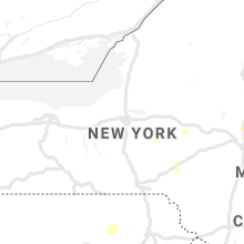
New York
| Local Time | Report Details |
|---|---|
| 2:17 PM EDT | Tree down on wires on city terrace in orange county NY, 55.7 miles N of Brooklyn, NY |
| 2:30 PM EDT | Tree down on cairns mills road. time estimate in cortland county NY, 24.7 miles SSE of Syracuse, NY |
| 2:46 PM EDT | Two trees snapped with debris on route 9n near sabbath day point in warren county NY, 57.7 miles SSW of Burlington, VT |
| 2:50 PM EDT | Several 6" diameter branches down on route 245 in yates county NY, 63.4 miles WSW of Syracuse, NY |
| 3:00 PM EDT | Tree down in dresden on state route 2 in washington county NY, 56.6 miles S of Burlington, VT |
| 3:06 PM EDT | Tree down on blue goose road and state route 22 intersection. time is radar estimate in washington county NY, 60 miles NNE of Schenectady, NY |
| 3:15 PM EDT | Trees and wires down in hampto in washington county NY, 61.4 miles S of Burlington, VT |
| 3:20 PM EDT | Tree down at the intersection of route 4 and old fair haven rd. time estimated from radar in washington county NY, 61 miles NNE of Schenectady, NY |
| 3:25 PM EDT | Tree on house on telephone road near knickerbocker roa in cortland county NY, 38.4 miles SSE of Syracuse, NY |
| 3:26 PM EDT | Downed tree on ny 120 both directions north of armonk-bedford rd in westchester county NY, 33.6 miles NNE of Brooklyn, NY |
| 3:51 PM EDT | Tree down across route 50 in saratoga county NY, 8.7 miles NNE of Schenectady, NY |
| 3:55 PM EDT | 1 tree down on lansing avenue. time estimated from rada in rensselaer county NY, 13.8 miles E of Schenectady, NY |
| 3:55 PM EDT | One tree down on river road in schaghticoke. time estimated by rada in rensselaer county NY, 14.2 miles ENE of Schenectady, NY |
| 4:15 PM EDT | Multiple trees and wires down... along state highway in otsego county NY, 66.9 miles WSW of Schenectady, NY |
| 4:20 PM EDT | As per dispatch feed... multiple trees down including blockage of highway 28. power also out in the villag in delaware county NY, 65.9 miles WSW of Schenectady, NY |
| 4:48 PM EDT | Lawn furniture strewn in yard... large branch down... small window dislodged from frame. radar-based tim in delaware county NY, 58.1 miles NNE of Scranton, PA |
New Hampshire
| Local Time | Report Details |
|---|---|
| 2:25 PM EDT | Half Dollar sized hail reported near Charlestown, NH, 81.4 miles ENE of Schenectady, NY, measured on rt 123a... 1 hail with some 1.25 stones mixed in. |
| 2:40 PM EDT | Golf Ball sized hail reported near Charlestown, NH, 84.9 miles ENE of Schenectady, NY, storm also damaged home anemometer. |
| 2:50 PM EDT | Golf Ball sized hail reported near South Acworth, NH, 88.3 miles ENE of Schenectady, NY, between acworth and south acworth on hill road off of rte 123a. |
| 3:30 PM EDT | Trees and wires down on mercier rd. time estimated from rada in coos county NH, 102.9 miles ENE of Burlington, VT |
| 3:45 PM EDT | Golf Ball sized hail reported near Westmoreland, NH, 76.9 miles E of Schenectady, NY, hail up to 1.75... hail lasted for 10 minutes. minor damage to car hood. |
| 3:45 PM EDT | Trees and wires down in town on route 63. time estimated from rada in cheshire county NH, 76.5 miles E of Schenectady, NY |
| 4:32 PM EDT | Half Dollar sized hail reported near Center Barnstead, NH, 54.5 miles WSW of Portland, ME, hail for 8 mins. |
| 4:35 PM EDT | Trees downed on summit roa in cheshire county NH, 83.3 miles E of Schenectady, NY |
| 4:35 PM EDT | Trees and wires down in town. reported by sheriffs office. time estimated from rada in carroll county NH, 47.7 miles WNW of Portland, ME |
| 4:45 PM EDT | Corrects time from previous tstm wnd dmg report from 2 e stark. trees and wires down on kelley rd. time estimated from rada in coos county NH, 85 miles NW of Portland, ME |
| 4:45 PM EDT | Trees and wires down on marlboro st. time estimated from rada in cheshire county NH, 85.7 miles E of Schenectady, NY |
| 5:15 PM EDT | Tree limbs down on mccoy r in hillsborough county NH, 74.5 miles NNW of Providence, RI |
| 5:25 PM EDT | Trees and wires down on hadley highway. time estimated from rada in hillsborough county NH, 71 miles NNW of Providence, RI |
| 5:25 PM EDT | Trees and wires down on kelley rd. time estimated from rada in coos county NH, 85 miles NW of Portland, ME |
| 5:25 PM EDT | Corrects previous tstm wnd dmg report from 2 sw temple. trees and wires down on moran rd. time estimated from rada in hillsborough county NH, 71.2 miles NNW of Providence, RI |
| 5:25 PM EDT | Corrects previous tstm wnd dmg report from 2 sw temple. trees and wires down on moran rd. time estimated from rada in hillsborough county NH, 71.2 miles NNW of Providence, RI |
| 5:30 PM EDT | Tons of trees down reported in town by police. time estimated from rada in coos county NH, 79.6 miles E of Burlington, VT |
| 5:30 PM EDT | Trees down in town. reported by sheriffs office. time estimated from rada in grafton county NH, 72.4 miles E of Burlington, VT |
| 5:45 PM EDT | Trees and wires down on north street. time estimated from rada in hillsborough county NH, 71.1 miles N of Providence, RI |
| 5:45 PM EDT | Trees and wires down transvale rd. time estimated from rada in carroll county NH, 49.9 miles WNW of Portland, ME |
| 7:30 PM EDT | Trees down on nh-113 and willoughby rd. time estimated from rada in grafton county NH, 65.7 miles W of Portland, ME |
| 7:30 PM EDT | Police report trees and wires down. time estimated from rada in grafton county NH, 65.6 miles W of Portland, ME |
Indiana
| Local Time | Report Details |
|---|---|
| 2:36 PM EDT | Trees and power lines dow in crawford county IN, 52 miles WNW of Louisville, KY |
| 2:44 PM EDT | Half dozen of trees snapped along hwy 6 in crawford county IN, 50.7 miles WNW of Louisville, KY |
| 3:53 PM EDT | Asos station kfwa fort wayne international a in allen county IN, 7.8 miles SSW of Fort Wayne, IN |
| 4:45 PM EDT | Trees and power poles down on north end of kokom in howard county IN, 49.9 miles N of Indianapolis, IN |
| 5:12 PM EDT | Two trees down across roads (550w and 500 w) east of 31 and southwest of sharpsvill in tipton county IN, 36.9 miles N of Indianapolis, IN |
Illinois
| Local Time | Report Details |
|---|---|
| 2:10 PM CDT | Tree fell on house. report relayed by broadcast media. time estimated by rada in peoria county IL, 5 miles NNW of Peoria, IL |
| 2:10 PM CDT | Powerline down. reported relayed by broadcast media. time estimated by rada in peoria county IL, 6 miles NNW of Peoria, IL |
| 2:20 PM CDT | Large healthy limb fell on two parked vehicles in the city of freepor in stephenson county IL, 54.9 miles SSW of Madison, WI |
| 2:40 PM CDT | Large tree limb fell on phone and power lines at west college and keiser avenues. time estimated from rada in mclean county IL, 32.4 miles ESE of Peoria, IL |
| 2:55 PM CDT | Tree limbs down on metrolink tracks near the fairview heights statio in st. clair county IL, 8.5 miles ESE of Saint Louis, MO |
| 3:10 PM CDT | Tree limbs down on highway 15 near national shrine of our lady of the snow in st. clair county IL, 7.5 miles SE of Saint Louis, MO |
| 4:53 PM CDT | Tree snapped in back yard. around 12 inches in diamete in henry county IL, 59.6 miles NNW of Peoria, IL |
| 5:25 PM CDT | Two large trees were blown down blocking the road and a fair bit of corn laying down in the area of cedar road and baker roa in will county IL, 34.4 miles SSW of Chicago, IL |
| 6:00 PM CDT | Large tree down in edgar county IL, 38.5 miles ENE of Mattoon, IL |
| 7:10 PM CDT | Photo shared on twitter of a large tree limb blown down. time estimate in kankakee county IL, 52.7 miles SSW of Chicago, IL |
Vermont
| Local Time | Report Details |
|---|---|
| 3:12 PM EDT | Ping Pong Ball sized hail reported near Fair Haven, VT, 60.5 miles S of Burlington, VT, hail damage to the siding of a house. |
| 3:30 PM EDT | Trees and powerlines dow in rutland county VT, 60.3 miles NE of Schenectady, NY |
| 3:45 PM EDT | Trees dow in orleans county VT, 62.9 miles ENE of Burlington, VT |
| 3:45 PM EDT | Trees dow in orleans county VT, 68.8 miles ENE of Burlington, VT |
| 4:00 PM EDT | Numerous trees... power poles and power lines knocked over. reports of damage to several structures as wel in rutland county VT, 60.4 miles NE of Schenectady, NY |
| 4:20 PM EDT | Power outages extending from swanton to alburgh were reported due to power lines and trees being blown dow in franklin county VT, 31 miles N of Burlington, VT |
| 4:21 PM EDT | Off-duty officer reported tree down between brunswick and bloomfield on route-10 in essex county VT, 80.2 miles ENE of Burlington, VT |
| 4:35 PM EDT | Trees... powerlines... and poles dow in franklin county VT, 29.3 miles NE of Burlington, VT |
| 4:35 PM EDT | Trees... powerlines... and poles dow in franklin county VT, 25.9 miles NNE of Burlington, VT |
| 4:35 PM EDT | Trees... powerlines... and poles dow in franklin county VT, 30.8 miles NNE of Burlington, VT |
| 4:40 PM EDT | Trees and powerlines down on georgia shore roa in franklin county VT, 19 miles N of Burlington, VT |
| 4:43 PM EDT | Trees and powerlines down on woody driv in franklin county VT, 23.9 miles N of Burlington, VT |
| 4:50 PM EDT | Trees and powerlines down on lake roa in chittenden county VT, 13.2 miles NNE of Burlington, VT |
| 4:54 PM EDT | Tree and powerlines down on middle roa in chittenden county VT, 11 miles NNE of Burlington, VT |
| 5:04 PM EDT | Trees and powerline down on coon hill r in chittenden county VT, 7.7 miles NNE of Burlington, VT |
| 5:12 PM EDT | 12 inch diameter tree dow in chittenden county VT, 5.4 miles ENE of Burlington, VT |
| 5:12 PM EDT | Large tree limbs down and damaged siding on londonderry lan in chittenden county VT, 7 miles ENE of Burlington, VT |
| 5:15 PM EDT | Trees and powerlines down on old stage rd and center r in chittenden county VT, 7.9 miles ENE of Burlington, VT |
| 5:22 PM EDT | Trees down along skunk hollow rd... barber farm rd... and browns trace r in chittenden county VT, 11.2 miles E of Burlington, VT |
| 5:36 PM EDT | Numerous power outages from fallen trees and power line in chittenden county VT, 18 miles ESE of Burlington, VT |
| 6:00 PM EDT | Multiple power outages being reported from fayston to waitsfield to moretown due to fallen trees and power line in washington county VT, 23.7 miles SE of Burlington, VT |
| 6:08 PM EDT | Trees and power lines dow in washington county VT, 35.5 miles SE of Burlington, VT |
Iowa
| Local Time | Report Details |
|---|---|
| 2:51 PM CDT | Rsois clocked in at 50 knot in scott county IA, 61.9 miles ESE of Cedar Rapids, IA |
| 2:55 PM CDT | Asos clocked in at 58 mp in scott county IA, 61.9 miles ESE of Cedar Rapids, IA |
| 3:27 PM CDT | Tree blown down at 35th and marquett in scott county IA, 63.3 miles ESE of Cedar Rapids, IA |
| 3:43 PM CDT | Several trees down due to thunderstorm wind in scott county IA, 63.6 miles ESE of Cedar Rapids, IA |
Mississippi
| Local Time | Report Details |
|---|---|
| 3:00 PM CDT | Power line down near new hope rd and kokomo r in marion county MS, 80.7 miles SSE of Jackson, MS |
| 3:05 PM CDT | Tree down on pittman r in marion county MS, 71.3 miles SSE of Jackson, MS |
| 3:20 PM CDT | A tree was reported down on tatum salt dome roa in lamar county MS, 86.1 miles NNE of New Orleans, LA |
Missouri
| Local Time | Report Details |
|---|---|
| 3:22 PM CDT | Trained spotter observed a downed tree branch near harvester road and mcclay rd. size unknown and wind gust estimated to 45 mp in st. charles county MO, 22.5 miles WNW of Saint Louis, MO |
Ohio
| Local Time | Report Details |
|---|---|
| 4:41 PM EDT | Power poles leaning... greenhouse roof taken off. time estimated from rada in henry county OH, 49.3 miles NE of Fort Wayne, IN |
| 5:43 PM EDT | Quarter sized hail reported near Celina, OH, 44.1 miles SSE of Fort Wayne, IN |
| 5:54 PM EDT | 1 1/2 ft tree limb fell on house. time estimated from rada in mercer county OH, 46 miles SE of Fort Wayne, IN |
| 6:00 PM EDT | 1 foot diameter tree down. limbs dow in lucas county OH, 88.7 miles ENE of Fort Wayne, IN |
| 7:00 PM EDT | Numerous trees and power lines down. roads closed due to a lot of damag in ottawa county OH, 78.8 miles W of Cleveland, OH |
Pennsylvania
| Local Time | Report Details |
|---|---|
| 5:10 PM EDT | Trees and wires down. time estimate in wyoming county PA, 23.9 miles WNW of Scranton, PA |
| 5:13 PM EDT | Trees and wires down in turbot townshi in northumberland county PA, 56.6 miles ENE of State College, PA |
| 5:25 PM EDT | Vehicle stuck between downed trees or branches. wires down with power outages on vosburg road... as per dispatch fee in wyoming county PA, 21.5 miles NW of Scranton, PA |
| 5:35 PM EDT | Tree down blocking both directions of route 87 as per dispatch fee in wyoming county PA, 24.5 miles WNW of Scranton, PA |
| 5:55 PM EDT | Trees and wires down. time estimate in wyoming county PA, 28.2 miles WNW of Scranton, PA |
| 6:03 PM EDT | Trees down on wire in york county PA, 49.2 miles N of Baltimore, MD |
| 6:07 PM EDT | Trees down on wire in york county PA, 50.7 miles N of Baltimore, MD |
| 6:09 PM EDT | Trees down in east buffalo township south of linntow in union county PA, 51.3 miles ENE of State College, PA |
| 6:17 PM EDT | Trees down on wire in sullivan county PA, 38.8 miles W of Scranton, PA |
| 6:23 PM EDT | Trees down on wire in snyder county PA, 48.3 miles E of State College, PA |
| 6:27 PM EDT | Trees down on wires on lilac lan in sullivan county PA, 35.4 miles W of Scranton, PA |
| 6:29 PM EDT | Tree on wires along freeburg road near iron ore driv in snyder county PA, 47.2 miles E of State College, PA |
| 6:33 PM EDT | Tree down across route 220 in laporte. corrected time from previous repor in sullivan county PA, 41.6 miles W of Scranton, PA |
| 6:35 PM EDT | Trees down on wire in snyder county PA, 48.3 miles E of State College, PA |
| 7:20 PM EDT | Trees down on wire in lycoming county PA, 57 miles NE of State College, PA |
| 7:26 PM EDT | Trees down on wire in juniata county PA, 42.4 miles ESE of State College, PA |
| 7:33 PM EDT | Tree down across route 220 in laport in sullivan county PA, 41.6 miles W of Scranton, PA |
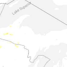
Minnesota
| Local Time | Report Details |
|---|---|
| 5:40 PM CDT | Multiple trees dow in otter tail county MN, 65.4 miles ESE of Fargo, ND |
| 6:50 PM CDT | Quarter sized hail reported near Brainerd, MN, 89.8 miles SSE of Bemidji, MN |
| 6:53 PM CDT | Quarter sized hail reported near Pillager, MN, 80.5 miles SSE of Bemidji, MN |
| 7:04 PM CDT | Quarter sized hail reported near Brainerd, MN, 91.3 miles SSE of Bemidji, MN |
| 7:09 PM CDT | Quarter sized hail reported near Motley, MN, 78.3 miles S of Bemidji, MN |
| 7:14 PM CDT | Quarter sized hail reported near Pillager, MN, 79.5 miles S of Bemidji, MN |
| 7:43 PM CDT | Golf Ball sized hail reported near Motley, MN, 77.7 miles S of Bemidji, MN |
| 8:07 PM CDT | Quarter sized hail reported near Aitkin, MN, 83.1 miles WSW of Duluth, MN, hailstone next to quarter picture sent in via twitter. |
| 8:30 PM CDT | Quarter sized hail reported near Aitkin, MN, 68.1 miles WSW of Duluth, MN |
| 9:15 PM CDT | Hen Egg sized hail reported near Ortonville, MN, 43.9 miles NW of Montevideo, MN, time estimated by radar. report relayed through nws employee and social media. |
| 9:45 PM CDT | Quarter sized hail reported near Nisswa, MN, 71.1 miles SSE of Bemidji, MN |
| 9:58 PM CDT | Quarter sized hail reported near Ortonville, MN, 42.7 miles NW of Montevideo, MN, time estimated by radar and social media report. relayed through nws employee and social media. |
| 10:05 PM CDT | Quarter sized hail reported near Pequot Lakes, MN, 65.8 miles SSE of Bemidji, MN, dime to quarter size hail. location approximate. |
| 11:21 PM CDT | Quarter sized hail reported near Walker, MN, 33.3 miles SSE of Bemidji, MN |
| 12:15 AM CDT | Hen Egg sized hail reported near Nevis, MN, 35.6 miles S of Bemidji, MN, corrects previous hail report from dorset. time updated to reflect message from em. |
| 12:35 AM CDT | Measured by mn dot rwi in wilkin county MN, 59.3 miles SSE of Fargo, ND |
| 12:45 AM CDT | Quarter sized hail reported near Tintah, MN, 54.7 miles SSE of Fargo, ND, lots of hail... large piles in yard. |
| 12:45 AM CDT | Hen Egg sized hail reported near Park Rapids, MN, 39.1 miles SSW of Bemidji, MN, corrects previous hail report from park rapids. pic relayed thru social media from public. chat with em and from pic agree on 2.0 inch size. |
| 12:50 AM CDT | Quarter sized hail reported near Park Rapids, MN, 39.1 miles SSW of Bemidji, MN |
| 12:55 AM CDT | Hen Egg sized hail reported near Nevis, MN, 35.6 miles S of Bemidji, MN, time estimated by radar. |
| 1:00 AM CDT | Storm damage reported in wilkin county MN, 46.1 miles SSE of Fargo, ND |
| 1:05 AM CDT | Quarter sized hail reported near Backus, MN, 48.4 miles SSE of Bemidji, MN |
| 1:23 AM CDT | Hen Egg sized hail reported near Park Rapids, MN, 39.1 miles SSW of Bemidji, MN, pic relayed thru social media from public. chat with em and from pic agree on 2.0 inch size. |
| 2:23 AM CDT | Pkd aso in hubbard county MN, 39.1 miles SSW of Bemidji, MN |
| 2:26 AM CDT | Quarter sized hail reported near Bemidji, MN, 8.8 miles N of Bemidji, MN, report of quarter hail and torrential rainfall 8 miles north of bemidji via social media. |
| 2:30 AM CDT | Asos station kaxn alexandria mn aso in douglas county MN, 65.3 miles NNE of Montevideo, MN |
| 2:45 AM CDT | Numerous trees down at shallow lak in hubbard county MN, 34.8 miles S of Bemidji, MN |
| 4:00 AM CDT | Quarter sized hail reported near Isanti, MN, 35.3 miles N of Minneapolis, MN, picture on twitter. |
| 4:45 AM CDT | Quarter sized hail reported near Minneapolis, MN, 10 miles SSW of Minneapolis, MN |
| 4:54 AM CDT | Quarter sized hail reported near Minneapolis, MN, 11.8 miles S of Minneapolis, MN |
| 5:05 AM CDT | Quarter sized hail reported near Minneapolis, MN, 10.4 miles S of Minneapolis, MN, picture on twitter. |
| 5:40 AM CDT | Quarter sized hail reported near Hastings, MN, 25.1 miles SE of Minneapolis, MN |
| 5:43 AM CDT | Half Dollar sized hail reported near Hastings, MN, 26.2 miles SE of Minneapolis, MN, picture on twitter. |
Colorado
| Local Time | Report Details |
|---|---|
| 4:44 PM MDT | Storm damage reported in logan county CO, 57.2 miles NW of Yuma, CO |
| 6:11 PM MDT | Co034 at 1812 md in sedgwick county CO, 64 miles NNE of Yuma, CO |
| 6:29 PM MDT | Storm damage reported in sedgwick county CO, 55.5 miles NNE of Yuma, CO |
Wisconsin
| Local Time | Report Details |
|---|---|
| 6:50 PM CDT | Golf Ball sized hail reported near Lake Nebagamon, WI, 25.9 miles SE of Duluth, MN, quarter to golf ball sized hail reported. |
| 7:45 PM CDT | Quarter sized hail reported near Iron River, WI, 38.6 miles ESE of Duluth, MN, sent to the office via twitter. tweet included picture of hailstone next to a quarter. |
| 8:30 PM CDT | Birch tree was downed. caller said that it was not the healthiest tree as the leaves were looking less healthy than last year. approximately 10-12 inches in diamete in bayfield county WI, 60.4 miles SE of Duluth, MN |
| 10:02 PM CDT | Fire department was called to remove a large tree 14 inches in diameter that had fallen and taken out power lines. department was called at 11:40 pm to move the tree. t in iron county WI, 48.2 miles NW of Rhinelander, WI |
| 10:02 PM CDT | Trees down over roadways along highway 13 between port wing and the bayfield/douglas county border. time estimated by rada in bayfield county WI, 29.9 miles E of Duluth, MN |
| 10:05 PM CDT | 9-inch diameter healthy tree dow in iron county WI, 43.5 miles NW of Rhinelander, WI |
| 10:13 PM CDT | Trees down over roadways between iron river and delta... wi. time estimated by rada in bayfield county WI, 41.3 miles ESE of Duluth, MN |
| 10:30 PM CDT | A few trees down in vilas county WI, 44.9 miles NNW of Rhinelander, WI |
| 10:33 PM CDT | A couple trees down in vilas county WI, 31.7 miles NW of Rhinelander, WI |
| 10:39 PM CDT | Asos station kasx ashland airpor in ashland county WI, 58.5 miles ESE of Duluth, MN |
| 10:50 PM CDT | A few trees down in vilas county WI, 44.9 miles NNW of Rhinelander, WI |
| 10:53 PM CDT | A couple trees down in vilas county WI, 31.7 miles NW of Rhinelander, WI |
| 11:50 PM CDT | Trees down in town. also house fire due to lightning strik in oneida county WI, 20.4 miles NW of Rhinelander, WI |
| 5:05 AM CDT | Ping Pong Ball sized hail reported near Chippewa Falls, WI, 83.2 miles N of La Crosse, WI, time estimated. |
Georgia
| Local Time | Report Details |
|---|---|
| 8:30 PM EDT | 2 trees reported down along rolling creek drive n in gwinnett county GA, 33.8 miles NE of Atlanta, GA |
| 8:30 PM EDT | Large tree down along stoneleigh run drive which damaged the roof of a ca in gwinnett county GA, 36 miles NE of Atlanta, GA |
| 9:30 PM EDT | Tall pine tree down along rosewood lane which damage vehicle windshiel in forsyth county GA, 34.9 miles NNE of Atlanta, GA |
South Dakota
| Local Time | Report Details |
|---|---|
| 9:00 PM CDT | Mesonet station 244 sd rwis ft. randall da in gregory county SD, 41.1 miles N of Oneill, NE |
| 9:50 PM CDT | Golf Ball sized hail reported near Carpenter, SD, 63.2 miles SSE of Aberdeen, SD |
| 3:07 AM MDT | Quarter sized hail reported near Kyle, SD, 69.3 miles SE of Rapid City, SD |
North Dakota
| Local Time | Report Details |
|---|---|
| 12:37 AM CDT | Peak gusts from personal weather statio in richland county ND, 54.2 miles S of Fargo, ND |
| 1:00 AM CDT | Trees down in the cit in richland county ND, 42.6 miles S of Fargo, ND |
Connect with Interactive Hail Maps