

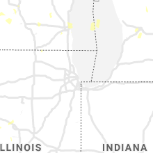
Hail Map for Thursday, July 9, 2020

Number of Impacted Households on 7/9/2020
0
Impacted by 1" or Larger Hail
0
Impacted by 1.75" or Larger Hail
0
Impacted by 2.5" or Larger Hail
Square Miles of Populated Area Impacted on 7/9/2020
0
Impacted by 1" or Larger Hail
0
Impacted by 1.75" or Larger Hail
0
Impacted by 2.5" or Larger Hail


Cities Most Affected by Hail Storms of 7/9/2020
| Hail Size | Demographics of Zip Codes Affected | ||||||
|---|---|---|---|---|---|---|---|
| City | Count | Average | Largest | Pop Density | House Value | Income | Age |
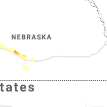
| Alliance, NE | 3 | 1.83 | 2.00 | 10 | $73k | $39.4k | 40.8 |
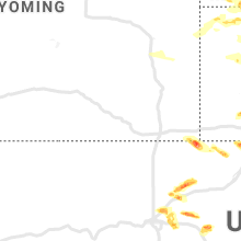
| Gillette, WY | 2 | 2.13 | 2.50 | 14 | $103k | $48.9k | 31.7 |
| Hermosa, SD | 1 | 2.75 | 2.75 | 3 | $127k | $35.4k | 44.4 |
| Keystone, SD | 1 | 2.50 | 2.50 | 9 | $97k | $31.4k | 50.6 |
| Bennett, CO | 1 | 2.50 | 2.50 | 16 | $141k | $55.3k | 40.3 |
| Watkins, CO | 1 | 2.00 | 2.00 | 9 | $232k | $64.1k | 38.1 |
| Deer Trail, CO | 1 | 1.75 | 1.75 | 1 | $111k | $37.3k | 42.8 |
| Beulah, WY | 1 | 1.75 | 1.75 | 0 | $134k | $29.5k | 43.3 |
| Mullen, NE | 1 | 1.75 | 1.75 | 0 | $41k | $28.7k | 49.6 |
| Mapleton, ME | 1 | 1.75 | 1.75 | 15 | $67k | $35.7k | 44.0 |
| Stoneham, CO | 1 | 1.75 | 1.75 | 0 | $90k | $30.8k | 47.3 |
Hail and Wind Damage Spotted on 7/9/2020
Filter by Report Type:Hail ReportsWind Reports
States Impacted
Wisconsin, Minnesota, Arkansas, Iowa, Maine, Kentucky, Ohio, Michigan, Georgia, Indiana, Pennsylvania, South Dakota, Tennessee, Colorado, West Virginia, Texas, Illinois, Nebraska, Wyoming, Montana, KansasWisconsin
| Local Time | Report Details |
|---|---|
| 7:00 AM CDT | Reports of power line down in north menomonie and a 12 inch diameter tree snapped off 10 feet above ground in downtown area. approximate tim in dunn county WI, 65.8 miles E of Minneapolis, MN |
| 7:15 AM CDT | Quarter sized hail reported near Cornell, WI, 90.6 miles WSW of Rhinelander, WI |
| 1:20 PM CDT | Several sources reported tree damag in jefferson county WI, 34.8 miles ENE of Madison, WI |
| 2:00 PM CDT | Trees reported down across highway 80 between necedah and new lisbon. also... reports of trees down on highway 58... county road a... county road g and several other in juneau county WI, 58.8 miles E of La Crosse, WI |
| 2:10 PM CDT | A few trees reported down in necedah... germantown... and clearfield areas. time estimate in juneau county WI, 62.8 miles ENE of La Crosse, WI |
| 3:00 PM CDT | Large tree dow in washington county WI, 68.2 miles ENE of Madison, WI |
| 4:45 PM CDT | Trees and power lines down in arena. time estimated from rada in iowa county WI, 27.1 miles WNW of Madison, WI |
| 5:00 PM CDT | Tree and power line damage in the sauk city are in sauk county WI, 22 miles NW of Madison, WI |
| 5:03 PM CDT | Tree damage in the area. part of a large tree in road at grand ave and 6th stree in sauk county WI, 22.9 miles NW of Madison, WI |
| 6:26 PM CDT | Trees and part of a power line down near delavan lake. time estimated from rada in walworth county WI, 50.8 miles SE of Madison, WI |
| 6:35 PM CDT | Several large trees dow in walworth county WI, 45.4 miles ESE of Madison, WI |
| 7:02 PM CDT | Trees and power lines down between dousman and eagle on highway 67. time estimated from rada in waukesha county WI, 46.6 miles E of Madison, WI |
| 7:14 PM CDT | Multiple large uprooted trees on lac la belle dr. relayed through broadcast medi in waukesha county WI, 43.6 miles E of Madison, WI |
| 7:17 PM CDT | Racine batten airport measured 59 knot gus in racine county WI, 61.2 miles N of Chicago, IL |
| 7:20 PM CDT | Large tree down in caledonia. time estimated from rada in racine county WI, 63.9 miles N of Chicago, IL |
| 7:25 PM CDT | A couple of large tree branches down at cliffside par in racine county WI, 65.3 miles N of Chicago, IL |
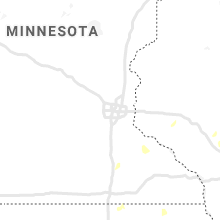
Minnesota
| Local Time | Report Details |
|---|---|
| 9:14 AM CDT | Tree knocked ove in st. louis county MN, 2.9 miles W of Duluth, MN |
| 2:41 PM CDT | One tree branch down. time estimated from rada in houston county MN, 22.6 miles SW of La Crosse, WI |
Arkansas
| Local Time | Report Details |
|---|---|
| 10:06 AM CDT | Observed by kxna asos in benton county AR, 60.5 miles N of Fort Smith, AR |
| 10:11 AM CDT | Tree down in west fayettevill in washington county AR, 48.8 miles NNE of Fort Smith, AR |
| 10:25 AM CDT | Several trees down in springdale near highway 41 in washington county AR, 57.9 miles NNE of Fort Smith, AR |
| 11:25 AM CDT | Tree down in alm in crawford county AR, 13.1 miles ENE of Fort Smith, AR |
| 12:51 PM CDT | Trees and powerlines dow in yell county AR, 55.9 miles ESE of Fort Smith, AR |
| 1:42 PM CDT | Social media video of a large mature tree being blown over was shown on an evening news segmen in lonoke county AR, 17.7 miles ENE of Little Rock, AR |
Iowa
| Local Time | Report Details |
|---|---|
| 10:27 AM CDT | Trees down in algon in kossuth county IA, 52.3 miles W of Mason City, IA |
| 11:45 AM CDT | Wind gust at the mason city airpor in cerro gordo county IA, 6.5 miles W of Mason City, IA |
| 12:15 PM CDT | Several trees blown dow in mitchell county IA, 21.5 miles NE of Mason City, IA |
| 12:33 PM CDT | Large tree uprooted and many tree limbs down throughout town of cedar falls. report via kwwl. report via social media. time estimated by rada in black hawk county IA, 54 miles NW of Cedar Rapids, IA |
| 12:35 PM CDT | Crops flattened... many trees uprooted of various sizes... playground set demolished... and power out. report via social medi in black hawk county IA, 52.3 miles SE of Mason City, IA |
| 12:40 PM CDT | Large trees uprooted and tree limbs down. mailbox damaged. report via social medi in black hawk county IA, 56.2 miles SE of Mason City, IA |
| 12:40 PM CDT | Large tree smashed pickup truck. photo via social media. time estimate in black hawk county IA, 55.7 miles NW of Cedar Rapids, IA |
| 12:50 PM CDT | Storm damage reported in black hawk county IA, 54.9 miles NW of Cedar Rapids, IA |
| 1:13 PM CDT | Storm damage reported in black hawk county IA, 54.9 miles NW of Cedar Rapids, IA |
| 1:20 PM CDT | One tree branch down. time estimated from rada in chickasaw county IA, 45.5 miles E of Mason City, IA |
| 1:29 PM CDT | Large branches down. estimating 50 to 60 mph wind in fayette county IA, 50.1 miles NNW of Cedar Rapids, IA |
| 1:35 PM CDT | 5 trees down on west charles st. a few other trees down in tow in fayette county IA, 50.1 miles NNW of Cedar Rapids, IA |
| 1:38 PM CDT | Roof blown off of building. branches down. time estimated based on rada in fayette county IA, 65.8 miles SSW of La Crosse, WI |
| 1:40 PM CDT | Several 8-10 inch tree branches snapped off tree in buchanan county IA, 39.6 miles N of Cedar Rapids, IA |
| 1:44 PM CDT | One tree branch down on garag in winneshiek county IA, 53.3 miles SW of La Crosse, WI |
| 2:10 PM CDT | Tree and powerline damage in postvill in allamakee county IA, 52.4 miles SSW of La Crosse, WI |
| 2:20 PM CDT | Large tree limb broken off tree... about 6 inches or large in benton county IA, 19.9 miles W of Cedar Rapids, IA |
| 2:22 PM CDT | Tree and powerline damage in the waukon area. time estimate in allamakee county IA, 39.2 miles SSW of La Crosse, WI |
| 3:20 PM CDT | Recorded by rwi in linn county IA, 3.2 miles S of Cedar Rapids, IA |
| 3:49 PM CDT | Video sent from social media of a tree falling in a yard and onto the roa in linn county IA, 1.1 miles S of Cedar Rapids, IA |
| 3:50 PM CDT | Social media submitted photo of a tree snapped by the wind. at least 6 inches in diameter trunk. estimated time to be 330-345pm... but the radar estimate is at 350p in delaware county IA, 33.7 miles NE of Cedar Rapids, IA |
| 4:40 PM CDT | Reported at dubuque regional airport aso in dubuque county IA, 57.5 miles ENE of Cedar Rapids, IA |
| 6:30 PM CDT | 3 inch diameter branch down. time estimated from rada in scott county IA, 65.9 miles ESE of Cedar Rapids, IA |
Maine
| Local Time | Report Details |
|---|---|
| 1:23 PM EDT | 2 trees down on state roa in aroostook county ME, 18.4 miles SW of Caribou, ME |
| 6:30 PM EDT | Ping Pong Ball sized hail reported near Mapleton, ME, 15.5 miles SSW of Caribou, ME |
| 6:40 PM EDT | Golf Ball sized hail reported near Mapleton, ME, 18.1 miles S of Caribou, ME, lots of leaf debris from hail. |
Kentucky
| Local Time | Report Details |
|---|---|
| 1:25 PM EDT | Large tree down blocking old frankfort pik in fayette county KY, 43.5 miles NW of Irvine, KY |
| 1:45 PM EDT | Tree down near the old capitol parking structure off ky 42 in franklin county KY, 48 miles ENE of Louisville, KY |
| 1:45 PM EDT | Report of a tree dow in franklin county KY, 48.2 miles ENE of Louisville, KY |
| 1:45 PM EDT | Tree down near the thornhill bypas in franklin county KY, 50.4 miles ENE of Louisville, KY |
| 1:45 PM EDT | Transformer sparking due to a tree down on reilly r in franklin county KY, 49.1 miles ENE of Louisville, KY |
| 1:45 PM EDT | Reports of trees down on devils hollow access r in franklin county KY, 46.9 miles ENE of Louisville, KY |
| 3:02 PM EDT | Large tree down on e-z street. several other trees down in dry ridg in grant county KY, 29.7 miles S of Cincinnati, OH |
| 3:02 PM EDT | Trees down in the four corners area of dry ridg in grant county KY, 30 miles S of Cincinnati, OH |
Ohio
| Local Time | Report Details |
|---|---|
| 2:53 PM EDT | Leaning power pole and tree limbs down between stubbs mills and shawhan r in warren county OH, 26.5 miles NE of Cincinnati, OH |
| 2:57 PM EDT | Quarter sized hail reported near Morrow, OH, 26.2 miles NE of Cincinnati, OH |
| 3:56 PM EDT | Large tree fell onto mobile home and car. photo evidence provide in butler county OH, 21.7 miles N of Cincinnati, OH |
| 3:56 PM EDT | Supporting pillars on house blown away on randall driv in butler county OH, 21 miles N of Cincinnati, OH |
| 4:14 PM EDT | Several trees down across the are in trumbull county OH, 54.9 miles ESE of Cleveland, OH |
| 4:20 PM EDT | Part of tree down on mobile home. time estimated from rada in allen county OH, 54.9 miles ESE of Fort Wayne, IN |
| 4:44 PM EDT | Numerous reports of branches and power lines down. location approximate. time estimated from rada in van wert county OH, 31.1 miles ESE of Fort Wayne, IN |
| 4:45 PM EDT | Healthy tree 18-24 inch diameter uprooted. time estimated from rada in preble county OH, 44.9 miles N of Cincinnati, OH |
| 5:17 PM EDT | Photo of large tree snapped about 6-10 feet from the base. rot visible. em reports numerous trees and large branches down in this general are in van wert county OH, 36.6 miles ESE of Fort Wayne, IN |
| 5:18 PM EDT | Barn roof blown of in van wert county OH, 37.4 miles SE of Fort Wayne, IN |
| 6:14 PM EDT | Tree and power lines down on hom in henry county OH, 62 miles ENE of Fort Wayne, IN |
| 6:14 PM EDT | Semi-truck blown ove in henry county OH, 61.8 miles ENE of Fort Wayne, IN |
| 7:20 PM EDT | A couple trees reported down east side of bellevue. time estimated from rada in huron county OH, 59.7 miles WSW of Cleveland, OH |
| 7:29 PM EDT | Tree leaning on home south side of sandusky. also a couple other trees down across southern side of sandusky. time estimated by rada in erie county OH, 52.8 miles W of Cleveland, OH |
| 7:51 PM EDT | Trees knocked down. time estimated from rada in scioto county OH, 74.6 miles S of Columbus, OH |
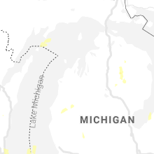
Michigan
| Local Time | Report Details |
|---|---|
| 4:12 PM EDT | Tree down at colfax and taylo in kent county MI, 1.6 miles N of Grand Rapids, MI |
| 5:50 PM EDT | Microburst. spruce tree snapped. vinyl fence panels blown ou in kent county MI, 11.1 miles SSW of Grand Rapids, MI |
| 5:53 PM EDT | Microburst. several public reports and photos between byron center and cutlerville of snapped or uprooted trees. occurred with half inch hai in kent county MI, 10.1 miles S of Grand Rapids, MI |
| 6:17 PM EDT | Trees blocking road on cr 628... e of m-33 about 4-6 miles north of atlant in montmorency county MI, 35.1 miles W of Alpena, MI |
| 6:24 PM EDT | Powerlines dow in st. clair county MI, 39 miles ENE of Flint, MI |
| 6:30 PM EDT | Numerous trees down from thunderstorm winds. power and cable companies... as well as road commission clearing trees. time of storm based on radar and 911 calls to montm in montmorency county MI, 43.7 miles WSW of Alpena, MI |
| 6:30 PM EDT | Downed powerline in buel township near peck and kilgore roads. time estimated based on rada in sanilac county MI, 52.3 miles ENE of Flint, MI |
| 6:49 PM EDT | Tree down on cabin from winds off of lake. time estimated from rada in montmorency county MI, 44.7 miles WSW of Alpena, MI |
| 6:51 PM EDT | Quarter sized hail reported near Lewiston, MI, 44.2 miles WSW of Alpena, MI |
| 9:50 PM EDT | *** 1 inj *** several 2-3 feet diameter trees downed. one large hardwood tree fell through a roof and into the living room of a home near todds lane and donovan road. e in washtenaw county MI, 43.7 miles S of Flint, MI |
| 10:21 PM EDT | Trees and wires downed near pettysville r in livingston county MI, 38.5 miles SSW of Flint, MI |
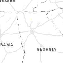
Georgia
| Local Time | Report Details |
|---|---|
| 4:40 PM EDT | Tree down along crestwood view road via public repor in union county GA, 76.6 miles S of Knoxville, TN |
| 4:40 PM EDT | Half Dollar sized hail reported near Blairsville, GA, 72.2 miles W of Greenville, SC, several reports of hail of quarter size to half dollar size to the se of blairsville in eastern union county. |
| 4:42 PM EDT | Quarter sized hail reported near Talking Rock, GA, 51.2 miles N of Atlanta, GA, hail up to quarter-sized fell along hunters ridge north of jasper. |
| 4:45 PM EDT | 2 trees down along arbor hills road north near talking rock. time estimated from rada in pickens county GA, 51.2 miles N of Atlanta, GA |
| 4:50 PM EDT | Quarter sized hail reported near Jasper, GA, 50.5 miles N of Atlanta, GA, quarter-sized hail fell for about 3 minutes and accummulated in grass along navaho trail drive in jasper. |
| 5:45 PM EDT | Half Dollar sized hail reported near Ellijay, GA, 51.1 miles ESE of Chattanooga, TN, hail a little larger than quarters falling north of ellijay... along bmw drive. |
| 7:05 PM EDT | Report of 2 trees down along tambec trace nw in the lilburn are in gwinnett county GA, 19.3 miles ENE of Atlanta, GA |
| 7:15 PM EDT | Large tree down along with some minor property damage along fairgreen drive north of stone mountain. time estimate in dekalb county GA, 14.2 miles ENE of Atlanta, GA |
Indiana
| Local Time | Report Details |
|---|---|
| 4:45 PM EDT | Report of several trees and power lines down... including one tree on residence near oak st and hauss av in clark county IN, 28.5 miles N of Louisville, KY |
Pennsylvania
| Local Time | Report Details |
|---|---|
| 5:22 PM EDT | A large tree was found across the road on route 8 on both south and north bound lane in allegheny county PA, 7.3 miles NNE of Pittsburgh, PA |
| 5:45 PM EDT | Report of 2 large trees down in franklin park area in allegheny county PA, 9.5 miles NNW of Pittsburgh, PA |
| 6:10 PM EDT | Several reports of trees down in the vicinity of cecil townshi in washington county PA, 12.6 miles SW of Pittsburgh, PA |
| 6:35 PM EDT | Trees and power lines down around intersection of bank street and 2nd st in greene county PA, 41.1 miles SSW of Pittsburgh, PA |
| 7:00 PM EDT | Several trees have fallen on crucible rd... blocking one lane near the intersections of river rd and old ferry r in greene county PA, 33.7 miles S of Pittsburgh, PA |
| 7:00 PM EDT | A couple trees were down across home run roa in washington county PA, 29.3 miles SSW of Pittsburgh, PA |
| 7:10 PM EDT | Several trees down on sr88 north of the sr188 intersection to the washington county lin in greene county PA, 33.7 miles S of Pittsburgh, PA |
| 7:45 PM EDT | Trees and wires down on 1700 block east maiden street in south strabane township. other trees reported down in the area as wel in washington county PA, 22.2 miles SSW of Pittsburgh, PA |
| 7:52 PM EDT | Multiple trees down 800 block east wilmington s in washington county PA, 23.5 miles SW of Pittsburgh, PA |
| 8:34 PM EDT | Multiple trees down in the elgin-beaver dam are in erie county PA, 79.4 miles SSW of Buffalo, NY |
| 10:08 PM EDT | Tree down blocking the road at main and avella in washington county PA, 22.3 miles SSW of Pittsburgh, PA |
| 10:08 PM EDT | Tree down blocking the road at main and avella in washington county PA, 19.5 miles WSW of Pittsburgh, PA |
| 10:20 PM EDT | A couple of trees down blocking roads in washington county PA, 17.8 miles WSW of Pittsburgh, PA |
South Dakota
| Local Time | Report Details |
|---|---|
| 3:50 PM MDT | Tennis Ball sized hail reported near Keystone, SD, 16.4 miles SSW of Rapid City, SD, 1.5 inch to 2.5 inch hail |
| 3:56 PM MDT | Baseball sized hail reported near Hermosa, SD, 17.4 miles SSW of Rapid City, SD, mostly ping pong ball to golfball size... some up to baseball size |
| 4:22 PM MDT | Ping Pong Ball sized hail reported near Hermosa, SD, 22.9 miles S of Rapid City, SD, hail began at 422 pm... and is still hailing. |
| 4:22 PM MDT | Ping Pong Ball sized hail reported near Hermosa, SD, 20.3 miles S of Rapid City, SD |
| 4:45 PM MDT | Half Dollar sized hail reported near Fairburn, SD, 29.2 miles S of Rapid City, SD |
| 8:30 PM MDT | Quarter sized hail reported near Oelrichs, SD, 67.2 miles S of Rapid City, SD |
Tennessee
| Local Time | Report Details |
|---|---|
| 6:00 PM EDT | Several trees down across alco in blount county TN, 12.2 miles SSW of Knoxville, TN |
| 6:00 PM EDT | Several trees down throughout maryvill in blount county TN, 14.8 miles S of Knoxville, TN |
| 6:00 PM EDT | Quarter sized hail reported near Maryville, TN, 14.8 miles S of Knoxville, TN, time of hail estimated. |
Colorado
| Local Time | Report Details |
|---|---|
| 5:19 PM MDT | Golf Ball sized hail reported near Deer Trail, CO, 53 miles E of Denver, CO, spotter submitted photo of hail. time estimated by radar. |
| 6:40 PM MDT | Quarter sized hail reported near Bennett, CO, 32.4 miles ENE of Denver, CO, spotter has moved location from current record to near the intersection of 112th and hw 79... approx. 10 n of bennett. |
| 6:54 PM MDT | Quarter sized hail reported near Strasburg, CO, 38.2 miles ENE of Denver, CO |
| 7:57 PM MDT | Half Dollar sized hail reported near New Raymer, CO, 69.2 miles S of Scottsbluff, NE |
| 8:19 PM MDT | Golf Ball sized hail reported near Stoneham, CO, 65.2 miles NW of Yuma, CO, time estimated from radar. |
| 8:35 PM MDT | Quarter sized hail reported near Brighton, CO, 18.4 miles NNE of Denver, CO, strong winds were also occurring at the time of the report. time estimated by radar. |
| 8:35 PM MDT | Spotter reported small broken branches and debris being blown down the street. also... penny size hai in adams county CO, 16.5 miles NNE of Denver, CO |
| 8:40 PM MDT | Storm damage reported in adams county CO, 20.3 miles NNE of Denver, CO |
| 9:19 PM MDT | Quarter sized hail reported near Denver, CO, 18.4 miles ENE of Denver, CO, meteorologist reported a few quarter sized hailstones on pena blvd just west of dia. |
| 9:38 PM MDT | Hen Egg sized hail reported near Watkins, CO, 20.9 miles E of Denver, CO, photo of hen egg sized hail in watkins provided by spotter. time estimated by radar. |
| 9:45 PM MDT | Quarter sized hail reported near Bennett, CO, 30.5 miles E of Denver, CO, spotter sent a picture over twitter. |
| 10:10 PM MDT | Tennis Ball sized hail reported near Bennett, CO, 28 miles ESE of Denver, CO |
West Virginia
| Local Time | Report Details |
|---|---|
| 7:26 PM EDT | Tree down on west veterans memorial highway. in taylor county WV, 29.3 miles NW of Elkins, WV |
| 7:27 PM EDT | 9 trees down on bailey hollow road. tree roots pulled up a natural gas distribution lin in taylor county WV, 30.5 miles NW of Elkins, WV |
Texas
| Local Time | Report Details |
|---|---|
| 6:30 PM CDT | Storm damage reported in hall county TX, 27.6 miles NW of Childress, TX |
| 6:34 PM CDT | Quarter sized hail reported near Estelline, TX, 15.5 miles WNW of Childress, TX |
| 6:45 PM CDT | Roof blown off home and power poles down in hall county TX, 19 miles WNW of Childress, TX |
| 8:01 PM CDT | Half Dollar sized hail reported near Childress, TX, 24.2 miles WSW of Childress, TX, walnut size hail |
Illinois
| Local Time | Report Details |
|---|---|
| 6:41 PM CDT | Large tree limb blown down. photo shared on facebook. time estimate in cook county IL, 26.1 miles NW of Chicago, IL |
| 6:48 PM CDT | A large tree limb was blown down. photo shared on facebook. time estimate in lake county IL, 27.8 miles NW of Chicago, IL |
| 7:03 PM CDT | A large tree limb was blown down across a road. photo shared on twitter. time estimate in lake county IL, 37.8 miles NNW of Chicago, IL |
| 7:10 PM CDT | Large tree limbs were blown down. video shared on twitter. time estimate in kane county IL, 35.1 miles WNW of Chicago, IL |
| 7:49 PM CDT | Wind gusts estimated to 60 mph with 2 inch tree limbs blown dow in lake county IL, 32.4 miles NNW of Chicago, IL |
| 7:55 PM CDT | Crop damage in knox county IL, 41 miles NW of Peoria, IL |
| 8:15 PM CDT | Powerline down on the road. report relayed by broadcast medi in knox county IL, 28 miles NW of Peoria, IL |
| 8:20 PM CDT | Branch size around 10 inches in fulton county IL, 34.6 miles WSW of Peoria, IL |
| 8:50 PM CDT | Trees down and crops damaged in fulton county IL, 29.9 miles SW of Peoria, IL |
| 9:00 PM CDT | Large tree blocking the road in peoria county IL, 11.9 miles NNW of Peoria, IL |
| 9:12 PM CDT | Several limbs down across havana. one was large enough to knock a meter off a house. most of the downed limbs were 2-3 inches in diamete in mason county IL, 36.8 miles SW of Peoria, IL |
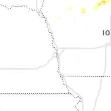
Nebraska
| Local Time | Report Details |
|---|---|
| 7:26 PM MDT | Quarter sized hail reported near Broadwater, NE, 46.2 miles ESE of Scottsbluff, NE |
| 8:16 PM MDT | Golf Ball sized hail reported near Mullen, NE, 58.9 miles SW of Valentine, NE, report with photo via social media. time estimated from radar. |
| 8:20 PM MDT | Quarter sized hail reported near Alliance, NE, 42.1 miles ENE of Scottsbluff, NE |
| 8:28 PM MDT | Quarter sized hail reported near Alliance, NE, 44 miles ENE of Scottsbluff, NE |
| 8:29 PM MDT | Golf Ball sized hail reported near Alliance, NE, 44 miles ENE of Scottsbluff, NE, hailing for the past 5 minutes. |
| 8:29 PM MDT | Golf Ball sized hail reported near Alliance, NE, 44.5 miles ENE of Scottsbluff, NE, reported at 707 flack ave... alliance... ne 69301. |
| 8:36 PM MDT | Hen Egg sized hail reported near Alliance, NE, 44 miles ENE of Scottsbluff, NE, via phone. |
| 8:40 PM MDT | Quarter sized hail reported near Ashby, NE, 86.9 miles NW of North Platte, NE |
| 11:51 PM CDT | Power knocked out in sutherland. report via public phone call in lincoln county NE, 19.2 miles W of North Platte, NE |
| 11:55 PM CDT | Semi blown over on i-80 near mm 160. report via social media. time estimated from rada in lincoln county NE, 17.1 miles W of North Platte, NE |
| 12:04 AM CDT | Home weather station pws-knenorth14 in lincoln county NE, 6.5 miles N of North Platte, NE |
| 12:20 AM CDT | Rsois gusted to 51 knot in lincoln county NE, 3.3 miles E of North Platte, NE |
| 12:24 AM CDT | Corrects previous tstm wnd gst report from 6 wnw maxwell. asos station klbf north platte airpor in lincoln county NE, 7.2 miles ESE of North Platte, NE |
| 12:30 AM CDT | Union pacific up101 in lincoln county NE, 5.4 miles ENE of North Platte, NE |
| 12:30 AM CDT | Union pacific up101 in lincoln county NE, 7.7 miles ESE of North Platte, NE |
| 1:10 AM CDT | Corrects time of previous tstm wnd dmg report from 1 wnw willow island. corrects location of previous tstm wnd dmg report from 5 w lexington. report via twitter of over in dawson county NE, 39.8 miles ESE of North Platte, NE |
| 6:14 AM UTC | Pictures via facebook of extensive tree damage and damage to an outbuilding. time estimated by rada in dawson county NE, 44.7 miles ESE of North Platte, NE |
| 1:18 AM CDT | Report via facebook. damage to a grain bin in cozad and power ou in dawson county NE, 45.2 miles ESE of North Platte, NE |
| 1:18 AM CDT | Storm damage reported in dawson county NE, 44.9 miles ESE of North Platte, NE |
| 1:22 AM CDT | Storm damage reported in dawson county NE, 45.2 miles ESE of North Platte, NE |
| 1:25 AM CDT | Report via twitter of overturned trailer blocking traffic on i-80 at mm218 w in dawson county NE, 54.2 miles ESE of North Platte, NE |
| 1:25 AM CDT | Corrects location of previous tstm wnd dmg report from 5 w lexington. report via twitter of overturned trailer blocking traffic on i-80 at mm218 w in dawson county NE, 39.8 miles ESE of North Platte, NE |
| 1:35 AM CDT | Awos station klxn lexington airpor in dawson county NE, 57.5 miles ESE of North Platte, NE |
Wyoming
| Local Time | Report Details |
|---|---|
| 8:55 PM MDT | Tennis Ball sized hail reported near Gillette, WY, 1.7 miles W of Gillette, WY |
| 9:00 PM MDT | Half Dollar sized hail reported near Gillette, WY, 1.2 miles SE of Gillette, WY |
| 9:00 PM MDT | Half Dollar sized hail reported near Gillette, WY, 1.2 miles SW of Gillette, WY |
| 9:00 PM MDT | Ping Pong Ball sized hail reported near Gillette, WY, 1.5 miles SE of Gillette, WY |
| 9:00 PM MDT | Golf Ball sized hail reported near Gillette, WY, 0.9 miles WNW of Gillette, WY |
| 9:05 PM MDT | Ping Pong Ball sized hail reported near Gillette, WY, 2.6 miles SSE of Gillette, WY |
| 10:45 PM MDT | Golf Ball sized hail reported near Beulah, WY, 53.5 miles NW of Rapid City, SD |
Montana
| Local Time | Report Details |
|---|---|
| 11:00 PM MDT | Storm damage reported in yellowstone county MT, 21.1 miles WNW of Billings, MT |
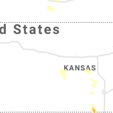
Kansas
| Local Time | Report Details |
|---|---|
| 6:34 AM CDT | Storm damage reported in harper county KS, 45 miles SW of Wichita, KS |
Connect with Interactive Hail Maps