

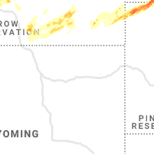
Hail Map for Tuesday, July 7, 2020

Number of Impacted Households on 7/7/2020
0
Impacted by 1" or Larger Hail
0
Impacted by 1.75" or Larger Hail
0
Impacted by 2.5" or Larger Hail
Square Miles of Populated Area Impacted on 7/7/2020
0
Impacted by 1" or Larger Hail
0
Impacted by 1.75" or Larger Hail
0
Impacted by 2.5" or Larger Hail


Cities Most Affected by Hail Storms of 7/7/2020
| Hail Size | Demographics of Zip Codes Affected | ||||||
|---|---|---|---|---|---|---|---|
| City | Count | Average | Largest | Pop Density | House Value | Income | Age |
| Roundup, MT | 6 | 1.92 | 2.50 | 4 | $55k | $25.4k | 48.9 |
| Buffalo, SD | 1 | 2.50 | 2.50 | 0 | $50k | $25.3k | 43.2 |
| Ryegate, MT | 1 | 2.00 | 2.00 | 0 | $51k | $29.3k | 49.9 |
| Shepherd, MT | 1 | 2.00 | 2.00 | 9 | $111k | $41.2k | 39.4 |
| Martinsdale, MT | 1 | 1.75 | 1.75 | 0 | $64k | $24.5k | 41.6 |
| Broadus, MT | 1 | 1.75 | 1.75 | 0 | $58k | $27.8k | 49.9 |
| Bozeman, MT | 1 | 1.75 | 1.75 | 64 | $158k | $35.0k | 30.5 |
| Lavina, MT | 1 | 1.75 | 1.75 | 1 | $45k | $26.4k | 48.0 |
| Ekalaka, MT | 1 | 1.75 | 1.75 | 0 | $23k | $25.4k | 50.1 |
Hail and Wind Damage Spotted on 7/7/2020
Filter by Report Type:Hail ReportsWind Reports
States Impacted
Indiana, Kentucky, Pennsylvania, Wisconsin, Ohio, Minnesota, Montana, Maryland, Colorado, Missouri, Iowa, Illinois, Texas, Arkansas, Nebraska, Michigan, West Virginia, South Dakota, Georgia, North DakotaIndiana
| Local Time | Report Details |
|---|---|
| 1:55 PM EDT | Tree down at porterfield rd and route 12 in wayne county IN, 54 miles NNW of Cincinnati, OH |
| 1:00 PM CDT | Photo of two pine trees snapped about 1-2 feet up from their base from social media. time estimated by rada in lake county IN, 35.5 miles SSE of Chicago, IL |
| 2:00 PM EDT | Several reports of large limbs and a few trees down on newcastle road 1-2 miles south of sia...i-65 and sr 38. a report of corn also knocked dow in tippecanoe county IN, 52.3 miles NW of Indianapolis, IN |
| 5:37 PM EDT | Tree limbs...approximately 2 to 3 inches in diameter...blown down. dime size hail accompanied the wind. report received via twitte in hendricks county IN, 17 miles WNW of Indianapolis, IN |
| 9:11 PM EDT | Semi truck and exit sign blown over. time estimated from rada in huntington county IN, 30.3 miles SW of Fort Wayne, IN |
| 9:11 PM EDT | Trees down on power lines. time estimated from rada in huntington county IN, 29.5 miles SW of Fort Wayne, IN |
Kentucky
| Local Time | Report Details |
|---|---|
| 2:00 PM EDT | Large tree fell on a deck and pool. time estimated using rada in fayette county KY, 37.9 miles WNW of Irvine, KY |
Pennsylvania
| Local Time | Report Details |
|---|---|
| 2:19 PM EDT | Downed tree limbs and wires near route 191 in coolbaugh twp. time estimated from rada in monroe county PA, 22.1 miles SE of Scranton, PA |
| 2:43 PM EDT | Downed tree on eagleville road near pinetown road in oaks. time estimated from rada in montgomery county PA, 85 miles WSW of Brooklyn, NY |
| 4:41 PM EDT | Limbs blown down and some shingles off a roof in butler county PA, 23.1 miles N of Pittsburgh, PA |
| 5:25 PM EDT | Trees and wires down in washington county PA, 18.3 miles WSW of Pittsburgh, PA |
| 7:15 PM EDT | Trees and power lines down on clay plant road. time estimated from rada in jefferson county PA, 59.9 miles WNW of State College, PA |
Wisconsin
| Local Time | Report Details |
|---|---|
| 1:30 PM CDT | Quarter sized hail reported near Onalaska, WI, 6.1 miles N of La Crosse, WI |
| 1:40 PM CDT | Quarter sized hail reported near Onalaska, WI, 6.2 miles NNE of La Crosse, WI, social media report. |
| 1:50 PM CDT | 5 power poles blown down north of trempealeau. time estimate in trempealeau county WI, 16.9 miles NNW of La Crosse, WI |
| 1:55 PM CDT | Tree limbs down... size unknown. power outage in trempealeau county WI, 16.5 miles NW of La Crosse, WI |
| 4:30 PM CDT | Several trees down in the city of dodgevill in iowa county WI, 38.4 miles WSW of Madison, WI |
| 6:45 PM CDT | Tree and branches down... fell on powerline that brought down a power pol in waukesha county WI, 65.2 miles E of Madison, WI |
Ohio
| Local Time | Report Details |
|---|---|
| 2:35 PM EDT | Several trees down in muskingum county OH, 58.2 miles E of Columbus, OH |
| 3:08 PM EDT | Tree reported down on south dayton brandt road. time estimated from rada in miami county OH, 56.1 miles W of Columbus, OH |
| 3:10 PM EDT | Tree and wires down in guernsey county OH, 77.1 miles E of Columbus, OH |
| 3:11 PM EDT | Large tree limbs dow in coshocton county OH, 66.2 miles ENE of Columbus, OH |
| 3:12 PM EDT | Trees down... and nickel size hail reported in coshocton county OH, 64.4 miles ENE of Columbus, OH |
| 5:02 PM EDT | Tree down. tree has some rot. tin roof from a barn blown of in van wert county OH, 34.6 miles ESE of Fort Wayne, IN |
| 5:16 PM EDT | Quarter sized hail reported near Delphos, OH, 42.2 miles ESE of Fort Wayne, IN, 1 in hail and measured 51 mph wind. |
| 6:49 PM EDT | Branches down. photo posted on social media. time estimated from rada in scioto county OH, 71.8 miles S of Columbus, OH |
Minnesota
| Local Time | Report Details |
|---|---|
| 2:03 PM CDT | Corn field flattened... damaged to 2 homes - extent unknow in fillmore county MN, 39.3 miles WSW of La Crosse, WI |
| 2:35 PM CDT | Tree down across highway 1 in houston county MN, 20.7 miles SW of La Crosse, WI |
| 4:19 AM CDT | Peak winds measured at a personal weather station located 10 ese breckenridg in wilkin county MN, 48.8 miles SSE of Fargo, ND |
| 4:20 AM CDT | Peak wind measured at an rwis statio in wilkin county MN, 34.6 miles SE of Fargo, ND |
| 4:20 AM CDT | Peak wind measured at an rwis statio in wilkin county MN, 59.3 miles SSE of Fargo, ND |
| 4:33 AM CDT | Peak wind measured at a personal weather statio in otter tail county MN, 53.3 miles SE of Fargo, ND |
| 4:35 AM CDT | Peak wind measured at the fergus falls airport /kffm in otter tail county MN, 52.1 miles SE of Fargo, ND |
| 5:15 AM CDT | Trees blown down... an irrigation system flipped... calf sheds tossed. strong winds from 510 through 520 am cdt. reports and photos posted via social medi in otter tail county MN, 75.4 miles ESE of Fargo, ND |
| 5:30 AM CDT | Peak winds measured at a personal weather station. strong and persistent winds with trees laying sideways. multiple gusts to 60 mph from 530 through 535 am cd in otter tail county MN, 69.1 miles SSW of Bemidji, MN |
| 5:34 AM CDT | Peak winds measured at a personal weather station. strong and persistent winds with trees laying sideway in otter tail county MN, 69.1 miles SSW of Bemidji, MN |
Montana
| Local Time | Report Details |
|---|---|
| 1:18 PM MDT | Quarter sized hail reported near Bozeman, MT, 5.4 miles SW of Bozeman, MT |
| 1:20 PM MDT | Quarter sized hail reported near Gallatin Gateway, MT, 7.4 miles SW of Bozeman, MT, report from mping: quarter (1.00 in.). |
| 1:25 PM MDT | Quarter sized hail reported near Bozeman, MT, 5.1 miles SSW of Bozeman, MT |
| 1:30 PM MDT | Golf Ball sized hail reported near Bozeman, MT, 5.3 miles ENE of Bozeman, MT |
| 1:30 PM MDT | Quarter sized hail reported near Bozeman, MT, 1.6 miles E of Bozeman, MT |
| 1:45 PM MDT | Quarter sized hail reported near Geraldine, MT, 46.8 miles ENE of Great Falls, MT, a few quarter size hail. mostly penny size hail. hail covered the ground. some crop damage. |
| 1:50 PM MDT | Storm damage reported in park county MT, 21.1 miles E of Bozeman, MT |
| 1:57 PM MDT | Half Dollar sized hail reported near Bozeman, MT, 5 miles SSW of Bozeman, MT, report from mping: half dollar (1.25 in.). |
| 1:59 PM MDT | Quarter sized hail reported near Geraldine, MT, 52.4 miles ENE of Great Falls, MT |
| 2:10 PM MDT | Golf Ball sized hail reported near Martinsdale, MT, 65.5 miles NNE of Bozeman, MT |
| 2:44 PM MDT | Storm damage reported in wheatland county MT, 79.4 miles NW of Billings, MT |
| 2:55 PM MDT | Ping Pong Ball sized hail reported near Denton, MT, 67.2 miles ESE of Great Falls, MT, few ping pong ball size hail stones. |
| 3:10 PM MDT | Grain bins put on their side and buildings damaged. trees stripped of vegetaio in wheatland county MT, 75.3 miles NW of Billings, MT |
| 3:10 PM MDT | Ping Pong Ball sized hail reported near Lewistown, MT, 87.8 miles S of Havre, MT, ping pong size hail... 45 mph wind gusts... and a little over 3/4 inches of heavy rainfall fell. |
| 3:15 PM MDT | Hen Egg sized hail reported near Ryegate, MT, 52 miles WNW of Billings, MT |
| 3:34 PM MDT | Awos station k1om osca in fergus county MT, 91.2 miles SSE of Havre, MT |
| 3:40 PM MDT | Quarter sized hail reported near Bozeman, MT, 5.5 miles S of Bozeman, MT, photo sent to office of 1in hail. |
| 3:41 PM MDT | Awos station k1nm novembe in fergus county MT, 92.3 miles NNW of Billings, MT |
| 3:52 PM MDT | Mesonet station jpkm8 judith peak raw in fergus county MT, 94.4 miles SSE of Havre, MT |
| 4:00 PM MDT | Half Dollar sized hail reported near Grass Range, MT, 87.2 miles N of Billings, MT, 4 minutes of hail ranging from pea to half dollar sized. |
| 4:03 PM MDT | Golf Ball sized hail reported near Lavina, MT, 33.6 miles NNW of Billings, MT |
| 4:03 PM MDT | Storm damage reported in golden valley county MT, 33.6 miles NNW of Billings, MT |
| 4:04 PM MDT | Mesonet station mcdm8 manning corral dogtow in phillips county MT, 80.7 miles SE of Havre, MT |
| 4:10 PM MDT | Golf Ball sized hail reported near Roundup, MT, 33.8 miles NNW of Billings, MT, golf ball hail from 410-420pm. |
| 4:10 PM MDT | Tennis Ball sized hail reported near Roundup, MT, 34 miles NNW of Billings, MT |
| 4:13 PM MDT | Hen Egg sized hail reported near Roundup, MT, 35.8 miles NNW of Billings, MT |
| 4:15 PM MDT | Golf Ball sized hail reported near Roundup, MT, 38.2 miles NNW of Billings, MT |
| 4:16 PM MDT | 71 mph wind gust blew tree down next to house. from social medi in phillips county MT, 68.5 miles SE of Havre, MT |
| 4:22 PM MDT | Mesonet station tr464 lewistown port no. in petroleum county MT, 90.3 miles SW of Glasgow, MT |
| 4:25 PM MDT | Quarter sized hail reported near Busby, MT, 83.2 miles ESE of Billings, MT |
| 4:25 PM MDT | Half Dollar sized hail reported near Winnett, MT, 82.2 miles N of Billings, MT |
| 4:30 PM MDT | Mesonet station mtmal 11.3 sw phillips (mt dot in phillips county MT, 75 miles ESE of Havre, MT |
| 4:30 PM MDT | 15-20 foot tall flowering crab apple tree down... along with a flagpole. received a little less than 1in of rai in blaine county MT, 44.6 miles ENE of Havre, MT |
| 4:30 PM MDT | 30 x 60 foot shed destroye in valley county MT, 38.3 miles NW of Glasgow, MT |
| 4:35 PM MDT | Quarter sized hail reported near Roundup, MT, 46.7 miles N of Billings, MT |
| 4:35 PM MDT | Storm damage reported in phillips county MT, 70 miles SE of Havre, MT |
| 4:36 PM MDT | Quarter sized hail reported near Roundup, MT, 46 miles N of Billings, MT |
| 4:36 PM MDT | Golf Ball sized hail reported near Roundup, MT, 41.9 miles N of Billings, MT |
| 4:40 PM MDT | Several trees blown over in the malta cemetery. from social medi in phillips county MT, 57.4 miles W of Glasgow, MT |
| 4:41 PM MDT | Personal weather statio in phillips county MT, 63.7 miles E of Havre, MT |
| 4:45 PM MDT | Golf Ball sized hail reported near Roundup, MT, 51.4 miles NNE of Billings, MT |
| 4:49 PM MDT | Storm damage reported in sweet grass county MT, 52.2 miles W of Billings, MT |
| 4:50 PM MDT | Hen Egg sized hail reported near Shepherd, MT, 13.1 miles NE of Billings, MT |
| 4:54 PM MDT | 3-4 foot chunks of tree branches down. a few bigger chunks in tow in blaine county MT, 61.2 miles ENE of Havre, MT |
| 4:55 PM MDT | Malta awo in phillips county MT, 60.4 miles WNW of Glasgow, MT |
| 4:58 PM MDT | Ping Pong Ball sized hail reported near Shepherd, MT, 11.8 miles NE of Billings, MT |
| 5:00 PM MDT | Quarter sized hail reported near Worden, MT, 17.1 miles NE of Billings, MT |
| 5:06 PM MDT | Mesonet station ssmm8 devils creek rec area 6es in garfield county MT, 60.4 miles SW of Glasgow, MT |
| 5:07 PM MDT | Storm damage reported in park county MT, 37.1 miles SE of Bozeman, MT |
| 5:18 PM MDT | Mesonet station fblm8 fort belknap raw in blaine county MT, 47.1 miles ESE of Havre, MT |
| 5:18 PM MDT | Mesonet station mtsco 1.9 e saco (mt dot in phillips county MT, 35.3 miles WNW of Glasgow, MT |
| 5:24 PM MDT | Wind pushed harrow 200 feet and picked up a grain bin and carried it over a wind break. wind also carried a few bulls... some other buildings... and a junk pile 300 yar in phillips county MT, 37.5 miles WNW of Glasgow, MT |
| 5:25 PM MDT | Siding and shingles peeled off hous in phillips county MT, 45.1 miles NW of Glasgow, MT |
| 5:30 PM MDT | 61 mph wind gust. multiple tree branches dow in roosevelt county MT, 43.2 miles ENE of Glasgow, MT |
| 5:37 PM MDT | Personal weather statio in valley county MT, 1.8 miles NNW of Glasgow, MT |
| 5:39 PM MDT | Personal weather statio in valley county MT, 3.8 miles N of Glasgow, MT |
| 5:40 PM MDT | Personal weather station measured wind gust of 70 mph along with 0.7 inch of rai in valley county MT, 34.3 miles NW of Glasgow, MT |
| 5:46 PM MDT | Mesonet station blum8 thoeny 1wsw/bluff cree in valley county MT, 48.8 miles NNW of Glasgow, MT |
| 5:47 PM MDT | Storm damage reported in rosebud county MT, 79.2 miles NNW of Gillette, WY |
| 5:50 PM MDT | Personal weather statio in valley county MT, 33.6 miles NNE of Glasgow, MT |
| 5:50 PM MDT | Public posted photo to social media showing a house with the roof completely remove in valley county MT, 15.5 miles SSE of Glasgow, MT |
| 5:53 PM MDT | Mesonet station 07mt 1.0 ne saint marie (ggwwfo in valley county MT, 15.8 miles NNE of Glasgow, MT |
| 6:00 PM MDT | Storm damage reported in valley county MT, 16 miles NNE of Glasgow, MT |
| 6:03 PM MDT | Storm damage reported in valley county MT, 37.8 miles NNE of Glasgow, MT |
| 6:05 PM MDT | Quarter sized hail reported near Broadus, MT, 67.6 miles S of Miles City, MT |
| 6:27 PM MDT | Golf Ball sized hail reported near Broadus, MT, 68.2 miles SSE of Miles City, MT |
| 6:28 PM MDT | Mesonet station fw0464 lustr in roosevelt county MT, 43.2 miles ENE of Glasgow, MT |
| 6:30 PM MDT | Quarter sized hail reported near Broadus, MT, 66.7 miles N of Gillette, WY |
| 6:35 PM MDT | Ping Pong Ball sized hail reported near Broadus, MT, 67.6 miles SSE of Miles City, MT |
| 6:51 PM MDT | Mesonet station mtcow 9.9 s vida (mt dot in mccone county MT, 63.7 miles ESE of Glasgow, MT |
| 6:54 PM MDT | Storm damage reported in garfield county MT, 36.2 miles NNW of Miles City, MT |
| 7:02 PM MDT | Ping Pong Ball sized hail reported near Broadus, MT, 77.8 miles NNE of Gillette, WY |
| 7:15 PM MDT | Storm damage reported in custer county MT, 2.5 miles NW of Miles City, MT |
| 7:22 PM MDT | Large tree branches down on i-94 at mile markers 144 and 14 in custer county MT, 7.6 miles NE of Miles City, MT |
| 7:30 PM MDT | Hopper bottom fertilizer bin blown over by thunderstorm winds. from social medi in sheridan county MT, 50.1 miles NW of Williston, ND |
| 7:41 PM MDT | Reported on social media. loss of power and damage to outdoor she in roosevelt county MT, 43.6 miles WNW of Williston, ND |
| 7:45 PM MDT | Half Dollar sized hail reported near Ekalaka, MT, 71.2 miles SE of Miles City, MT |
| 8:01 PM MDT | Mt dot commertown turn-off mt-mp statio in sheridan county MT, 54.1 miles NNW of Williston, ND |
| 8:12 PM MDT | Golf Ball sized hail reported near Ekalaka, MT, 91.5 miles SE of Miles City, MT |
Maryland
| Local Time | Report Details |
|---|---|
| 4:05 PM EDT | Two trees down near intersection of waxler rd. and fort ashby r in mineral county WV, 59.3 miles NE of Elkins, WV |
Colorado
| Local Time | Report Details |
|---|---|
| 2:32 PM MDT | Storm damage reported in adams county CO, 30.5 miles E of Denver, CO |
| 8:24 PM MDT | Storm damage reported in yuma county CO, 0.9 miles SE of Yuma, CO |
| 10:16 PM MDT | Storm damage reported in phillips county CO, 38.2 miles NE of Yuma, CO |
Missouri
| Local Time | Report Details |
|---|---|
| 4:35 PM CDT | Area of thunderstorm wind damage along hwy 17/historic route 66 from near ichord road to near bates street area. numerous large branches and trees down... some onto hou in pulaski county MO, 39.6 miles WNW of Salem, MO |
Iowa
| Local Time | Report Details |
|---|---|
| 5:00 PM CDT | Young tree split in half on byson road in northeast cedar rapi in linn county IA, 6.1 miles NNE of Cedar Rapids, IA |
| 5:00 PM CDT | Large tree limb broken off tree outside the news station. rebecca kopelman reporte in linn county IA, 4.1 miles NNE of Cedar Rapids, IA |
| 5:10 PM CDT | Part of a large tree has split off and destroyed a trampoline. snapped part is about 12 inches in diameter... based from phot in linn county IA, 6.1 miles NNE of Cedar Rapids, IA |
| 5:31 PM CDT | Several 3-5 inch diameter tree limbs that are dow in jones county IA, 26.8 miles ENE of Cedar Rapids, IA |
| 5:40 PM CDT | Delayed report via social media. corn flattened in a field from a probable downburs in jones county IA, 29.2 miles NE of Cedar Rapids, IA |
Illinois
| Local Time | Report Details |
|---|---|
| 5:33 PM CDT | A large tree limb was blown down. video shared on twitte in cook county IL, 20.4 miles NW of Chicago, IL |
| 6:05 PM CDT | Report of 2-4 inch diameter tree limbs dow in woodford county IL, 16.3 miles E of Peoria, IL |
| 6:14 PM CDT | Measured gust to 60 mp in cook county IL, 15.3 miles WNW of Chicago, IL |
| 6:20 PM CDT | Quarter sized hail reported near Franklin Park, IL, 12.4 miles WNW of Chicago, IL, spotter reported nickel size hail for several minutes with quarter size hail as it ended. duration 620 pm to 627 pm. |
| 7:16 PM CDT | A 5 foot diameter tree was blown down... which brought down power lines and a utility pole. tree was described as rotte in mchenry county IL, 58 miles NW of Chicago, IL |
Texas
| Local Time | Report Details |
|---|---|
| 5:35 PM CDT | 58 mph wind gust measured at curtis field in brad in mcculloch county TX, 90.9 miles SSE of Abilene, TX |
Arkansas
| Local Time | Report Details |
|---|---|
| 6:00 PM CDT | Numerous limbs down in the area as well as a couple of tree in baxter county AR, 79.1 miles SE of Springfield, MO |
Nebraska
| Local Time | Report Details |
|---|---|
| 5:15 PM MDT | Awos station kgrn gordon airpor in sheridan county NE, 82.9 miles W of Valentine, NE |
| 7:30 PM MDT | Power pole snapped... picture via social media. time estimated in cherry county NE, 61.4 miles W of Valentine, NE |
| 11:15 PM MDT | Storm damage reported in sheridan county NE, 83.4 miles W of Valentine, NE |
Michigan
| Local Time | Report Details |
|---|---|
| 7:17 PM EDT | Multiple trees... large limbs and power lines dow in oakland county MI, 44.9 miles SE of Flint, MI |
West Virginia
| Local Time | Report Details |
|---|---|
| 7:27 PM EDT | Trees blown down across george washington highway in belgium in taylor county WV, 31.1 miles NNW of Elkins, WV |
| 7:43 PM EDT | Multiple reports of trees down across the area. time of event is time of first call received in kanawha county WV, 1.8 miles WSW of Charleston, WV |
| 7:54 PM EDT | Trees and powerlines down in south charleston. local utility company also reports nearly 4...000 customers without power in the south charleston are in kanawha county WV, 3.9 miles W of Charleston, WV |
| 8:07 PM EDT | Powerlines down in eastview. also penny size hail near stonewood in harrison county WV, 34.6 miles NW of Elkins, WV |
| 8:07 PM EDT | Tree blown onto house on locust ave in harrison county WV, 36.6 miles NW of Elkins, WV |
| 8:08 PM EDT | Several pictures and reports of large healthy trees blown down across the clarksburg area in harrison county WV, 35 miles NW of Elkins, WV |
| 8:12 PM EDT | Quarter sized hail reported near Mount Clare, WV, 34 miles NW of Elkins, WV |
| 8:15 PM EDT | Powerlines down in eastview. also penny size hail near stonewood in harrison county WV, 34.6 miles NW of Elkins, WV |
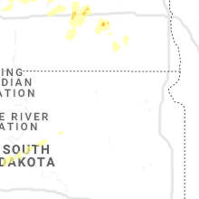
South Dakota
| Local Time | Report Details |
|---|---|
| 6:13 PM MDT | Storm damage reported in fall river county SD, 66.9 miles SW of Rapid City, SD |
| 6:30 PM MDT | Storm damage reported in jackson county SD, 69.1 miles NW of Valentine, NE |
| 6:55 PM MDT | Quarter sized hail reported near Philip, SD, 61.6 miles WSW of Pierre, SD |
| 7:55 PM MDT | From decaying storms east of martin in bennett county SD, 62.2 miles WNW of Valentine, NE |
| 8:10 PM MDT | Storm damage reported in pennington county SD, 36.4 miles E of Rapid City, SD |
| 8:40 PM MDT | Quarter sized hail reported near Camp Crook, SD, 105.3 miles ESE of Miles City, MT |
| 8:41 PM MDT | Tennis Ball sized hail reported near Buffalo, SD, 107.8 miles ESE of Miles City, MT, lasted 10 minutes |
| 8:59 PM MDT | Storm damage reported in haakon county SD, 44 miles WSW of Pierre, SD |
| 9:07 PM MDT | Storm damage reported in harding county SD, 117.5 miles ESE of Miles City, MT |
| 9:25 PM MDT | Half Dollar sized hail reported near Ludlow, SD, 121 miles N of Rapid City, SD |
Georgia
| Local Time | Report Details |
|---|---|
| 9:47 PM EDT | Large tree down in road along marilyn circl in catoosa county GA, 14.7 miles SE of Chattanooga, TN |
| 9:47 PM EDT | Tree down near home which damaged gutter along creeks bend d in catoosa county GA, 15.6 miles SE of Chattanooga, TN |
North Dakota
| Local Time | Report Details |
|---|---|
| 8:10 PM MDT | Sheriffs deputy relayed the report to the county emergency manage in bowman county ND, 102.9 miles E of Miles City, MT |
| 9:11 PM CDT | Williston airport aso in williams county ND, 9.5 miles NW of Williston, ND |
| 8:18 PM MDT | 60 to 70 mph wind gusts and heavy rai in slope county ND, 117.8 miles S of Williston, ND |
| 9:26 PM CDT | Ndawn sit in williams county ND, 28.7 miles NNE of Williston, ND |
| 8:30 PM MDT | Sand creek raw in slope county ND, 110.4 miles S of Williston, ND |
| 9:30 PM CDT | Damage report received via social media. shingles and soffit ripped off building. door to quonset caved in and additional tree damag in williams county ND, 9.7 miles SE of Williston, ND |
| 9:45 PM CDT | Ndawn sit in divide county ND, 48.3 miles NNE of Williston, ND |
| 9:45 PM CDT | Ongoing at the time of the cal in mckenzie county ND, 24.3 miles SE of Williston, ND |
| 9:52 PM CDT | 3 nw hawkeye ndawn sit in mckenzie county ND, 32.3 miles ESE of Williston, ND |
| 9:04 PM MDT | Dickinson airpor in stark county ND, 95.9 miles W of Bismarck, ND |
| 10:11 PM CDT | Mountrail county emergency manager reported strong winds. estimated around 60 mph... with his car shakin in mountrail county ND, 45.8 miles ENE of Williston, ND |
| 10:15 PM CDT | Awos station kd50 crosb in divide county ND, 56.1 miles NNE of Williston, ND |
| 9:16 PM MDT | Gladstone nddot sit in stark county ND, 84.1 miles W of Bismarck, ND |
| 10:16 PM CDT | Nddot sit in mountrail county ND, 53.7 miles ESE of Williston, ND |
| 9:25 PM MDT | Storm damage reported in stark county ND, 83.7 miles W of Bismarck, ND |
| 9:31 PM MDT | Gladstone nddot sit in stark county ND, 84.1 miles W of Bismarck, ND |
| 10:35 PM CDT | Report received via social media. shop had doors blown out and snapped cable on one side of bi-fold garage doo in burke county ND, 70.3 miles NE of Williston, ND |
| 9:55 PM MDT | Storm damage reported in grant county ND, 51 miles WSW of Bismarck, ND |
| 10:10 PM MDT | Nddot sit in mercer county ND, 69.1 miles WNW of Bismarck, ND |
| 11:13 PM CDT | Blaisdell nddot sit in mountrail county ND, 34.9 miles W of Minot, ND |
| 11:16 PM CDT | New salem nddot sit in morton county ND, 31.1 miles W of Bismarck, ND |
| 10:18 PM MDT | Knife river raws site. time estimated from rada in mercer county ND, 46 miles NW of Bismarck, ND |
| 10:24 PM MDT | Ndawn site 2w haze in mercer county ND, 54.6 miles NW of Bismarck, ND |
| 11:40 PM CDT | Report received via social media of a few big tree branches down and power lost several time in mclean county ND, 48.3 miles NNW of Bismarck, ND |
| 11:40 PM CDT | Bismarck airport aso in burleigh county ND, 2.2 miles SE of Bismarck, ND |
| 11:42 PM CDT | Washburn nddot site. time estimated from rada in mclean county ND, 36.3 miles NNW of Bismarck, ND |
| 11:42 PM CDT | Corrects previous tstm wnd dmg report from 2 s garrison. relayed through social media. garage door blown in. delayed repor in mclean county ND, 43 miles S of Minot, ND |
| 11:44 PM CDT | Storm damage reported in burleigh county ND, 2 miles SSE of Bismarck, ND |
| 11:46 PM CDT | Ndawn site 7s sawye in ward county ND, 20.5 miles SE of Minot, ND |
| 11:46 PM CDT | Nddot bismarck interstate 94 bridge sit in burleigh county ND, 2.6 miles WNW of Bismarck, ND |
| 11:56 PM CDT | Ndawn site 4n turtle lak in mclean county ND, 49.2 miles SSE of Minot, ND |
| 12:11 AM CDT | Sterling nddot site. time estimated from rada in burleigh county ND, 25.2 miles E of Bismarck, ND |
| 12:16 AM CDT | Long lake raws site. time estimated from rada in burleigh county ND, 27 miles ESE of Bismarck, ND |
| 12:30 AM CDT | Corrects previous tstm wnd dmg report from 1 w anamoose. law enforcement and fire department reporting many power lines down across the highway... as well as a building in mchenry county ND, 53.9 miles ESE of Minot, ND |
| 12:35 AM CDT | Large tree branches down in harve in wells county ND, 55.1 miles WSW of Devils Lake, ND |
| 12:46 AM CDT | Quarter sized hail reported near Litchville, ND, 68.5 miles WSW of Fargo, ND |
| 12:59 AM CDT | Awos station k46d carrington nd awos. time estimated from rada in foster county ND, 47.7 miles SSW of Devils Lake, ND |
| 1:10 AM CDT | Ndawn site 2n maddock in benson county ND, 32.3 miles WSW of Devils Lake, ND |
| 1:32 AM CDT | Ndawn site niles 3se measured at 10 meters in benson county ND, 21.9 miles WNW of Devils Lake, ND |
| 1:37 AM CDT | Law enforcement and fire department reporting many power lines down across the highway... as well as a building completely destroye in mchenry county ND, 53.9 miles ESE of Minot, ND |
| 1:56 AM CDT | Devils lake airport observation in ramsey county ND, 0.6 miles WSW of Devils Lake, ND |
| 1:57 AM CDT | Measured at cooperstown airport awos in griggs county ND, 58.6 miles SE of Devils Lake, ND |
| 2:16 AM CDT | Peak winds measured at an rwis statio in ramsey county ND, 3 miles SSW of Devils Lake, ND |
| 3:14 AM CDT | Quarter sized hail reported near Fargo, ND, 2.5 miles SW of Fargo, ND |
| 6:33 AM CDT | Relayed through social media. garage door blown i in mclean county ND, 43 miles S of Minot, ND |
Connect with Interactive Hail Maps