

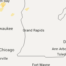
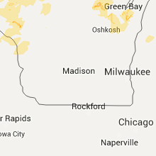
Hail Map for Friday, June 10, 2016

Number of Impacted Households on 6/10/2016
0
Impacted by 1" or Larger Hail
0
Impacted by 1.75" or Larger Hail
0
Impacted by 2.5" or Larger Hail
Square Miles of Populated Area Impacted on 6/10/2016
0
Impacted by 1" or Larger Hail
0
Impacted by 1.75" or Larger Hail
0
Impacted by 2.5" or Larger Hail


Cities Most Affected by Hail Storms of 6/10/2016
| Hail Size | Demographics of Zip Codes Affected | ||||||
|---|---|---|---|---|---|---|---|
| City | Count | Average | Largest | Pop Density | House Value | Income | Age |
| Hilger, MT | 4 | 1.94 | 2.00 | 1 | $52k | $29.1k | 49.5 |
| Roy, MT | 3 | 2.08 | 2.50 | 0 | $43k | $27.6k | 46.5 |
| Winnett, MT | 1 | 2.50 | 2.50 | 0 | $58k | $24.1k | 48.0 |
| Belt, MT | 1 | 2.00 | 2.00 | 2 | $80k | $32.0k | 43.0 |
| Geraldine, MT | 1 | 2.00 | 2.00 | 0 | $48k | $31.2k | 47.3 |
| Great Falls, MT | 1 | 1.75 | 1.75 | 81 | $92k | $32.4k | 34.0 |
| Highwood, MT | 1 | 1.75 | 1.75 | 1 | $100k | $37.7k | 46.3 |
| Bassett, NE | 1 | 1.75 | 1.75 | 1 | $41k | $25.5k | 50.4 |
| Spirit Lake, IA | 1 | 1.75 | 1.75 | 78 | $117k | $41.3k | 48.1 |
| Okabena, MN | 1 | 1.75 | 1.75 | 8 | $38k | $34.9k | 43.0 |
Hail and Wind Damage Spotted on 6/10/2016
Filter by Report Type:Hail ReportsWind Reports
Minnesota
| Local Time | Report Details |
|---|---|
| 1:25 PM CDT | Report of multiple trees down near intersection of highway 21 and county road 904. in st. louis county MN, 66 miles N of Duluth, MN |
| 1:25 PM CDT | Photos sent in of tree damage. tree snapped halfway up the trunk. time estimated by rada in st. louis county MN, 67.4 miles N of Duluth, MN |
| 2:43 PM CDT | Quarter sized hail reported near Sleepy Eye, MN, 66.7 miles SE of Montevideo, MN, . |
| 3:18 PM CDT | Six to eight inch trees down over house in town. power line also toppled. time estimated from radar. in le sueur county MN, 53.6 miles SSW of Minneapolis, MN |
| 3:36 PM CDT | Large branches down across road... power lines dow in goodhue county MN, 42.8 miles SE of Minneapolis, MN |
| 3:40 PM CDT | A few trees toppled. in le sueur county MN, 46.7 miles SSW of Minneapolis, MN |
| 3:44 PM CDT | Eight inch diameter tree down. in nicollet county MN, 66.9 miles SW of Minneapolis, MN |
| 3:45 PM CDT | Semi-trailer blown ove in le sueur county MN, 45.3 miles SSW of Minneapolis, MN |
| 3:45 PM CDT | Few trees and power lines down. occurred in rapida in blue earth county MN, 73.1 miles SW of Minneapolis, MN |
| 3:50 PM CDT | Multiple trees down in the city. time estimated from radar. in le sueur county MN, 40.3 miles SSW of Minneapolis, MN |
| 3:50 PM CDT | Few trees and power lines down. in blue earth county MN, 66.3 miles SSW of Minneapolis, MN |
| 3:55 PM CDT | Numerous trees and power lines toppled. in blue earth county MN, 73.9 miles NW of Mason City, IA |
| 4:05 PM CDT | Trees blown over road near county rd. 12 and independence ave. in rice county MN, 47 miles S of Minneapolis, MN |
| 4:05 PM CDT | Tree of 2.5 feet diameter down across road. occurred near 6th st. and 2nd ave. in rice county MN, 46.9 miles S of Minneapolis, MN |
| 4:35 PM CDT | Measured by mndot sensor south of cannon fall in goodhue county MN, 43.2 miles SSE of Minneapolis, MN |
| 4:50 PM CDT | Trees down reported just north of town in wabasha county MN, 55.3 miles NW of La Crosse, WI |
| 4:58 PM CDT | Numerous trees and power lines down in wabasha county MN, 60.7 miles SE of Minneapolis, MN |
| 6:10 PM CDT | Golf Ball sized hail reported near Okabena, MN, 72.7 miles E of Sioux Falls, SD, . |
| 6:35 PM CDT | Quarter sized hail reported near Lakefield, MN, 71.3 miles N of Storm Lake, IA, . |
| 6:45 PM CDT | Quarter sized hail reported near Lakefield, MN, 71.3 miles N of Storm Lake, IA, . |
Wisconsin
| Local Time | Report Details |
|---|---|
| 3:30 PM CDT | Multiple trees limbs down. power lines down. one of these occurred near 16th st e. power out over portion of town. in dunn county WI, 66.7 miles E of Minneapolis, MN |
| 3:35 PM CDT | Multiple 8 inch trees down. tree dmg was sporadic and not wide sprea in price county WI, 53.5 miles W of Rhinelander, WI |
| 3:48 PM CDT | Multiple trees and power lines down across the city. time estimated from rada in dunn county WI, 66.7 miles E of Minneapolis, MN |
| 3:50 PM CDT | Tree down near nugget park. in pierce county WI, 54.4 miles ESE of Minneapolis, MN |
| 3:50 PM CDT | 8 inch diameter tree downed at intersection of county highway h and county highway in iron county WI, 48.4 miles NW of Rhinelander, WI |
| 3:55 PM CDT | Large spruce tree blown dow in price county WI, 51 miles W of Rhinelander, WI |
| 3:55 PM CDT | Large trees toppled. barn door ripped off. occurred 14 miles east of ellsworth. in pierce county WI, 55.3 miles ESE of Minneapolis, MN |
| 3:55 PM CDT | Tree down on power line. in pierce county WI, 55.5 miles ESE of Minneapolis, MN |
| 4:00 PM CDT | Trees down in the western part of the county. also pea size hai in vilas county WI, 40.8 miles NNW of Rhinelander, WI |
| 4:02 PM CDT | Large pine tree down just south of phillips on highway 1 in price county WI, 47.5 miles W of Rhinelander, WI |
| 4:07 PM CDT | Medium size tree (4 inches in diameter)... toppled in nw portion of town. in eau claire county WI, 70.6 miles N of La Crosse, WI |
| 4:08 PM CDT | Quarter sized hail reported near Knapp, WI, 58.2 miles E of Minneapolis, MN, occurred near the knapp hill area on i-94. |
| 4:15 PM CDT | Large tree limbs/ 6 to 8 inch diameter branches down. wind estimated at 70 mph. occurred at coop site elrw3. in eau claire county WI, 70.6 miles N of La Crosse, WI |
| 4:18 PM CDT | Large trees down... some on a building. time estimate in oneida county WI, 20.4 miles NW of Rhinelander, WI |
| 4:20 PM CDT | Four to six inch branches dow in eau claire county WI, 70.6 miles N of La Crosse, WI |
| 4:20 PM CDT | Tree toppled onto house garage and vehicl in eau claire county WI, 69.5 miles N of La Crosse, WI |
| 4:22 PM CDT | Trees down. report relayed by wjfw-t in vilas county WI, 22 miles NNW of Rhinelander, WI |
| 4:25 PM CDT | Tree toppled. in chippewa county WI, 74.7 miles N of La Crosse, WI |
| 4:30 PM CDT | A couple trees on power line in lincoln county WI, 29.2 miles WSW of Rhinelander, WI |
| 4:40 PM CDT | A few trees dow in oneida county WI, 11.2 miles NNE of Rhinelander, WI |
| 4:45 PM CDT | Numerous trees and power lines down. in pepin county WI, 62.2 miles NW of La Crosse, WI |
| 5:12 PM CDT | A couple trees down near metonga lak in forest county WI, 25.5 miles ESE of Rhinelander, WI |
| 5:14 PM CDT | Trees on power lin in langlade county WI, 20.8 miles SSE of Rhinelander, WI |
| 5:21 PM CDT | Trees down just south of town in trempealeau county WI, 53 miles N of La Crosse, WI |
| 5:25 PM CDT | A few trees blown down in the vicinity of willard. time estimated from rada in clark county WI, 68.6 miles NNE of La Crosse, WI |
| 5:35 PM CDT | Trees and powerlines down. time estimated from rada in marinette county WI, 51.9 miles E of Rhinelander, WI |
| 5:35 PM CDT | Trees and powerlines down in the pembine and amberg areas. time estimated from rada in marinette county WI, 68.4 miles E of Rhinelander, WI |
| 5:37 PM CDT | Trees down along campground roa in clark county WI, 53.2 miles NNE of La Crosse, WI |
| 5:45 PM CDT | Large branches down in clark county WI, 74.1 miles NNE of La Crosse, WI |
| 5:47 PM CDT | Trees down in eastern langlade county. time estimate in langlade county WI, 35 miles SE of Rhinelander, WI |
| 5:47 PM CDT | Trees down near crooked lak in oconto county WI, 52.5 miles ESE of Rhinelander, WI |
| 5:55 PM CDT | Storm damage reported in marathon county WI, 74 miles SW of Rhinelander, WI |
| 5:55 PM CDT | Storm damage reported in clark county WI, 74.5 miles NNE of La Crosse, WI |
| 5:58 PM CDT | Quarter sized hail reported near Blair, WI, 29.8 miles N of La Crosse, WI |
| 6:00 PM CDT | Trees and powerlines down. time estimated from rada in marinette county WI, 58.6 miles N of Green Bay, WI |
| 6:04 PM CDT | Storm damage reported in wood county WI, 76.8 miles SSW of Rhinelander, WI |
| 6:20 PM CDT | Trees and power lines down around wisconsin rapids area. also trees down over much of the county. time estimated from rada in wood county WI, 81.1 miles ENE of La Crosse, WI |
| 6:45 PM CDT | On i-39. blowing dirt/dust reducing visibility. possible gustnado observe in portage county WI, 73.7 miles W of Green Bay, WI |
| 6:46 PM CDT | Quarter sized hail reported near Aniwa, WI, 42.3 miles S of Rhinelander, WI |
| 7:15 PM CDT | Trees down on highway 47. report relayed by wluk-t in menominee county WI, 39.7 miles NW of Green Bay, WI |
| 7:20 PM CDT | Trees down in shawano county WI, 44.1 miles WNW of Green Bay, WI |
| 7:38 PM CDT | Quarter sized hail reported near Shawano, WI, 32 miles WNW of Green Bay, WI |
| 7:40 PM CDT | Storm damage reported in waupaca county WI, 37.1 miles W of Green Bay, WI |
| 8:00 PM CDT | 911 center received numerous reports of trees down across the county from la valle to rock springs and baraboo between 8pm cdt and 820 pm cd in sauk county WI, 32.7 miles NNW of Madison, WI |
| 8:00 PM CDT | 911 center reported numerous trees down and 6 to 8 roads blocked by trees across northern and central portions of the county between 8 pm cdt and 820 pm cd in columbia county WI, 33.2 miles N of Madison, WI |
| 8:15 PM CDT | Numerous trees down... especially in the southern part of the count in brown county WI, 4.8 miles SSW of Green Bay, WI |
| 8:36 PM CDT | 911 call center received reports of trees and wires down scattered across the county between 836 pm cdt and 9 pm cd in sheboygan county WI, 54.6 miles SSE of Green Bay, WI |
| 8:40 PM CDT | Numerous trees down around the city of manitowoc and in the county. winds estimated well over 60 mp in manitowoc county WI, 34.6 miles SSE of Green Bay, WI |
Michigan
| Local Time | Report Details |
|---|---|
| 3:45 PM CDT | Two trees down on chaney lake road...blocking traffic in both direction in gogebic county MI, 53.1 miles NNW of Rhinelander, WI |
| 4:27 PM CDT | Large tree down on m-45 in gogebic county MI, 45.7 miles NNE of Rhinelander, WI |
| 9:15 PM EDT | Multiple trees and some utility lines down in frankfort area... reported by county dispatc in benzie county MI, 31.6 miles WSW of Traverse City, MI |
| 9:30 PM EDT | Medium size tree limbs dow in benzie county MI, 12.7 miles WSW of Traverse City, MI |
| 10:30 PM EDT | Several trees down around county. namely buckley and cadillac... reported by emergency manage in wexford county MI, 18.2 miles S of Traverse City, MI |
| 11:17 PM EDT | Two reports of power lines down. also getting reports of power outages in fremont as wel in newaygo county MI, 36.9 miles NNW of Grand Rapids, MI |
Montana
| Local Time | Report Details |
|---|---|
| 3:08 PM MDT | Quarter sized hail reported near Stockett, MT, 12.3 miles SE of Great Falls, MT |
| 3:35 PM MDT | Golf Ball sized hail reported near Highwood, MT, 31.2 miles E of Great Falls, MT, hail and wind lasted 14 minutes. no broken windows and no injuries. small tree limbs down. |
| 3:36 PM MDT | Hen Egg sized hail reported near Belt, MT, 24.3 miles E of Great Falls, MT, 2-inch hail...time estimated by radar. |
| 4:05 PM MDT | Quarter sized hail reported near Geraldine, MT, 48.9 miles E of Great Falls, MT |
| 4:40 PM MDT | Quarter sized hail reported near Monarch, MT, 35.6 miles SE of Great Falls, MT, hail up to quarter size falling. |
| 4:45 PM MDT | Hen Egg sized hail reported near Geraldine, MT, 51.8 miles E of Great Falls, MT, estimated hail falling up to 2 inches in diameter. |
| 5:37 PM MDT | Hen Egg sized hail reported near Hilger, MT, 75.9 miles S of Havre, MT |
| 5:42 PM MDT | Half Dollar sized hail reported near Denton, MT, 57.6 miles E of Great Falls, MT, estimated hail up to half dollar size. |
| 5:57 PM MDT | Hen Egg sized hail reported near Hilger, MT, 75.9 miles S of Havre, MT |
| 6:11 PM MDT | Two power poles dow in fergus county MT, 68.2 miles E of Great Falls, MT |
| 6:23 PM MDT | Hen Egg sized hail reported near Hilger, MT, 81.3 miles SSE of Havre, MT |
| 6:30 PM MDT | Quarter sized hail reported near Hilger, MT, 86.1 miles SSE of Havre, MT |
| 7:10 PM MDT | Golf Ball sized hail reported near Roy, MT, 87.3 miles SSE of Havre, MT |
| 7:18 PM MDT | 60 mph wind gust at the dot sensor just east of dento in fergus county MT, 69.8 miles ESE of Great Falls, MT |
| 7:21 PM MDT | Hen Egg sized hail reported near Roy, MT, 86 miles SSE of Havre, MT |
| 7:36 PM MDT | Quarter sized hail reported near Lewistown, MT, 87.8 miles S of Havre, MT, hail up to 1 inch in diameter. small tree branches around 1 inch broken off. |
| 7:41 PM MDT | Manning corral raws measured a 59 mph wind gus in phillips county MT, 78.1 miles SE of Havre, MT |
| 7:45 PM MDT | Golf Ball sized hail reported near Hilger, MT, 86.1 miles SSE of Havre, MT, broken window. |
| 8:00 PM MDT | Ping Pong Ball sized hail reported near Winnett, MT, 80.9 miles SW of Glasgow, MT |
| 8:41 PM MDT | Dry blood creek raws recored a wind gust at 72 mp in petroleum county MT, 100.2 miles N of Billings, MT |
| 8:45 PM MDT | Storm damage reported in fergus county MT, 92.9 miles WSW of Glasgow, MT |
| 8:45 PM MDT | Tennis Ball sized hail reported near Roy, MT, 92.9 miles WSW of Glasgow, MT |
| 8:45 PM MDT | Storm damage reported in petroleum county MT, 98.6 miles SW of Glasgow, MT |
| 8:45 PM MDT | Tennis Ball sized hail reported near Winnett, MT, 98.6 miles SW of Glasgow, MT |
| 9:56 PM MDT | Storm damage reported in garfield county MT, 61.8 miles SSW of Glasgow, MT |
| 9:56 PM MDT | Storm damage reported in garfield county MT, 61.8 miles SSW of Glasgow, MT |
| 10:04 PM MDT | Storm chasers had sustained 50 mph gusting to 60 mp in garfield county MT, 61.8 miles SSW of Glasgow, MT |
| 10:15 PM MDT | Storm chaser estimates wind gusts to 60 mp in garfield county MT, 60.6 miles S of Glasgow, MT |
| 10:26 PM MDT | Wind gust estimated at 70 mph by storm chaser in garfield county MT, 60.6 miles S of Glasgow, MT |
| 10:26 PM MDT | Wind gust estimated at 70 mph by storm chaser in garfield county MT, 60.6 miles S of Glasgow, MT |
| 10:30 PM MDT | Public reports a wind gust to 65 mp in dawson county MT, 75.9 miles WSW of Williston, ND |
| 11:35 PM MDT | Pea size hail about 10 minutes prior in dawson county MT, 80 miles SW of Williston, ND |
| 12:01 AM MDT | Storm damage reported in dawson county MT, 70.5 miles NE of Miles City, MT |
| 1:33 AM MDT | Quarter sized hail reported near Glasgow, MT, 2 miles W of Glasgow, MT |
| 1:35 AM MDT | Quarter sized hail reported near Glasgow, MT, 0.4 miles NNW of Glasgow, MT |
| 4:50 AM MDT | Quarter sized hail reported near Great Falls, MT, 4.8 miles SW of Great Falls, MT, quarter size hail fell at the wfo great falls office |
| 4:52 AM MDT | Quarter sized hail reported near Great Falls, MT, 0.9 miles ESE of Great Falls, MT |
| 4:55 AM MDT | Ping Pong Ball sized hail reported near Great Falls, MT, 0.9 miles ESE of Great Falls, MT |
| 4:55 AM MDT | Half Dollar sized hail reported near Great Falls, MT, 0.9 miles ESE of Great Falls, MT |
| 5:00 AM MDT | Golf Ball sized hail reported near Great Falls, MT, 3.6 miles E of Great Falls, MT, golf ball size hail reported on the east side of great falls. hail caused damage to vehicles |
Iowa
| Local Time | Report Details |
|---|---|
| 5:08 PM CDT | Quarter sized hail reported near Estherville, IA, 60.7 miles NNE of Storm Lake, IA |
| 5:25 PM CDT | Large hail reported...size unknow in emmet county IA, 63.6 miles NNE of Storm Lake, IA |
| 5:25 PM CDT | Reported at estherville airpor in emmet county IA, 55.2 miles NNE of Storm Lake, IA |
| 6:20 PM CDT | Quarter sized hail reported near Milford, IA, 47.2 miles N of Storm Lake, IA, . |
| 6:27 PM CDT | Quarter sized hail reported near Milford, IA, 47.2 miles N of Storm Lake, IA, social media report. |
| 6:30 PM CDT | Storm damage reported in dickinson county IA, 49.1 miles N of Storm Lake, IA |
| 7:40 PM CDT | Quarter sized hail reported near Lake Park, IA, 56.1 miles N of Storm Lake, IA, time estimated based on radar. |
| 8:00 PM CDT | Golf Ball sized hail reported near Spirit Lake, IA, 53.3 miles N of Storm Lake, IA, hailing for five minutes. |
| 8:00 PM CDT | Storm damage reported in dickinson county IA, 53.5 miles N of Storm Lake, IA |
| 8:20 PM CDT | Quarter sized hail reported near Milford, IA, 44.6 miles N of Storm Lake, IA, . |
| 8:45 PM CDT | Storm damage reported in clay county IA, 38.8 miles NNE of Storm Lake, IA |
| 8:45 PM CDT | Roof damage to hog barn and tree limb damage near and around st. benedict in kossuth county IA, 44.1 miles W of Mason City, IA |
| 9:00 PM CDT | Storm damage reported in clay county IA, 39.1 miles N of Storm Lake, IA |
| 9:14 PM CDT | Storm damage reported in clay county IA, 36.1 miles N of Storm Lake, IA |
| 9:15 PM CDT | Social media report...4 inch diameter branches dow in clay county IA, 34.1 miles N of Storm Lake, IA |
| 9:50 PM CDT | Social media repor in clay county IA, 29.2 miles N of Storm Lake, IA |
| 10:02 PM CDT | Social media repor in clay county IA, 29.2 miles N of Storm Lake, IA |
| 11:50 PM CDT | Quarter sized hail reported near Granville, IA, 42.3 miles WNW of Storm Lake, IA, . |
| 1:01 AM CDT | Storm damage reported in marshall county IA, 47.9 miles NE of Des Moines, IA |
| 1:30 AM CDT | Time estimated based on kccy awos gusts to 43 mph. about six 1-3 foot diameter trees downed in the city. the larger diameter trees were split growth at the lower trun in floyd county IA, 27.5 miles ESE of Mason City, IA |
| 2:21 AM CDT | Small tree branches down. in floyd county IA, 26.9 miles E of Mason City, IA |
| 2:36 AM CDT | Tree down in charles city. in floyd county IA, 26.9 miles E of Mason City, IA |
Florida
| Local Time | Report Details |
|---|---|
| 6:35 PM EDT | Citizen reported small trees downed by estimated 40-50 mph winds and pea sized hail along county road 147 in alachua county FL, 48.2 miles SW of Jacksonville, FL |
| 7:15 PM EDT | Alachua county 911/dispatch reports numerous trees down in gainesville and throughout southwestern alachua count in alachua county FL, 61.3 miles SW of Jacksonville, FL |
| 7:15 PM EDT | 911 call center reported shed destroyed at 7117 sw archer road. this in addition to approx 50 reports of trees down in the city of gainesville mostly on the sw side of in alachua county FL, 68.1 miles SW of Jacksonville, FL |
Nebraska
| Local Time | Report Details |
|---|---|
| 6:30 PM CDT | Golf Ball sized hail reported near Bassett, NE, 52.8 miles WSW of Oneill, NE, hail up to golf ball size |
Connect with Interactive Hail Maps