

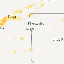
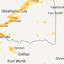
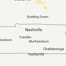
Hail Map for Tuesday, June 14, 2011

Number of Impacted Households on 6/14/2011
0
Impacted by 1" or Larger Hail
0
Impacted by 1.75" or Larger Hail
0
Impacted by 2.5" or Larger Hail
Square Miles of Populated Area Impacted on 6/14/2011
0
Impacted by 1" or Larger Hail
0
Impacted by 1.75" or Larger Hail
0
Impacted by 2.5" or Larger Hail


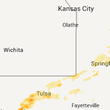


Cities Most Affected by Hail Storms of 6/14/2011
| Hail Size | Demographics of Zip Codes Affected | ||||||
|---|---|---|---|---|---|---|---|
| City | Count | Average | Largest | Pop Density | House Value | Income | Age |
| Cushing, OK | 3 | 2.42 | 2.75 | 64 | $53k | $28.5k | 39.3 |
| Ansley, NE | 3 | 2.25 | 2.50 | 3 | $23k | $28.3k | 45.9 |
| Norman, OK | 3 | 1.75 | 1.75 | 1569 | $77k | $31.4k | 29.2 |
| Oklahoma City, OK | 2 | 2.13 | 2.50 | 1849 | $74k | $34.7k | 38.7 |
| Drumright, OK | 1 | 1.75 | 1.75 | 52 | $47k | $28.9k | 39.5 |
| Carney, OK | 1 | 1.75 | 1.75 | 19 | $52k | $30.7k | 40.5 |
| New Boston, MO | 1 | 1.75 | 1.75 | 3 | $28k | $33.1k | 49.1 |
| Winner, SD | 1 | 1.75 | 1.75 | 4 | $55k | $29.0k | 45.4 |
| Clarks, NE | 1 | 1.75 | 1.75 | 5 | $39k | $32.0k | 45.6 |
| Linneus, MO | 1 | 1.75 | 1.75 | 6 | $34k | $30.8k | 43.3 |
| Bassett, NE | 1 | 1.75 | 1.75 | 1 | $41k | $25.5k | 50.4 |
| Sugar City, CO | 1 | 1.75 | 1.75 | 0 | $52k | $30.1k | 52.0 |
| Bethany, OK | 1 | 1.75 | 1.75 | 2552 | $72k | $35.3k | 36.8 |
| Spalding, NE | 1 | 1.75 | 1.75 | 1 | $45k | $30.8k | 44.6 |
| Cement, OK | 1 | 1.75 | 1.75 | 13 | $41k | $30.1k | 39.7 |
Hail and Wind Damage Spotted on 6/14/2011
Filter by Report Type:Hail ReportsWind Reports
States Impacted
Minnesota, Colorado, South Dakota, Florida, New Mexico, Kansas, Nebraska, Oklahoma, Missouri, Texas, Arkansas, Iowa, IllinoisMinnesota
| Local Time | Report Details |
|---|---|
| 4:40 PM UTC | Quarter sized hail reported near Jasper, MN, 26.7 miles NE of Sioux Falls, SD |
Colorado
| Local Time | Report Details |
|---|---|
| 5:30 PM UTC | Quarter sized hail reported near Genoa, CO, 66.4 miles SSW of Yuma, CO |
| 8:52 PM UTC | Golf Ball sized hail reported near Sugar City, CO, 51.8 miles E of Pueblo, CO, time estimated from radar image |
South Dakota
| Local Time | Report Details |
|---|---|
| 5:40 PM UTC | Quarter sized hail reported near Fairburn, SD, 23.6 miles S of Rapid City, SD, zero visibility from rain and hail. also report minor flooding on lame johnny creek. |
| 6:43 PM UTC | Quarter sized hail reported near Wood, SD, 43.4 miles N of Valentine, NE |
| 8:20 PM UTC | Golf Ball sized hail reported near Winner, SD, 33.4 miles NE of Valentine, NE |
| 8:50 PM UTC | Quarter sized hail reported near Orient, SD, 59.3 miles SW of Aberdeen, SD |
| 9:15 PM UTC | Half Dollar sized hail reported near Miller, SD, 59.6 miles ENE of Pierre, SD |
| 9:19 PM UTC | Quarter sized hail reported near Miller, SD, 63 miles ENE of Pierre, SD |
| 10:15 PM UTC | Quarter sized hail reported near Miller, SD, 66.3 miles E of Pierre, SD |
| 10:20 PM UTC | Quarter sized hail reported near Herrick, SD, 47 miles NW of Oneill, NE |
| 1:55 AM UTC | Storm damage reported in meade county SD, 22.7 miles ENE of Rapid City, SD |
Florida
| Local Time | Report Details |
|---|---|
| 7:20 PM UTC | Ksc 54 foot wind tower number 513 measured 50 kt/58 mph wind gus in brevard county FL, 41.7 miles E of Orlando, FL |
| 7:20 PM UTC | Ktts at nasa shuttle landing facility measured 65 kt/75 mph wind gus in brevard county FL, 40.4 miles E of Orlando, FL |
| 7:25 PM UTC | Ksc 54 foot wind tower number 412 measured 55 kt/63 mph wind gus in brevard county FL, 43.3 miles E of Orlando, FL |
| 7:25 PM UTC | Ksc 54 foot wind tower number 512 measured 63 kt/73 mph wind gus in brevard county FL, 42.2 miles E of Orlando, FL |
| 9:16 PM UTC | Trees and powerlines were blown down across near the intersection of se county road 232 and state road 4 in gilchrist county FL, 77.6 miles WSW of Jacksonville, FL |
| 9:20 PM UTC | Station reported 54 kt/62 mph wind gus in st. lucie county FL, 9.2 miles NE of Port Saint Lucie, FL |
| 9:25 PM UTC | Trees were blown down along highway 129 in bell. the time of the event was based on rada in gilchrist county FL, 82.2 miles WSW of Jacksonville, FL |
| 9:52 PM UTC | Quarter sized hail reported near Trenton, FL, 85.7 miles SW of Jacksonville, FL, quarter to pellet size hail was reported in trenton. |
| 9:52 PM UTC | Trees were blown down in trenton along highway 12 in gilchrist county FL, 85.7 miles SW of Jacksonville, FL |
| 9:55 PM UTC | Nws employee reported estimated wind gust of 60 mp in amz555 county FL, 8.9 miles E of Port Saint Lucie, FL |
| 12:50 AM UTC | A member of the public reported estimated wind speeds between 60 and 70 miles per hour near the intersection of kimberly boulevard and us-44 in palm beach county FL, 43.7 miles N of Miami, FL |
| 1:00 AM UTC | A trained spotter reported a wind gust of 60 kts...or 69 mph...recorded by a mesonet station near nw 31st street and the florida turnpike in broward count in broward county FL, 29.8 miles N of Miami, FL |
| 1:00 AM UTC | Media reports about 7700 residents without power across delray beach...boynton beach...and boca raton due to the storm in palm beach county FL, 51.2 miles N of Miami, FL |
New Mexico
| Local Time | Report Details |
|---|---|
| 8:25 PM UTC | Quarter sized hail reported near Moriarty, NM, 3235.6 miles ENE of Caribou, ME |
Kansas
| Local Time | Report Details |
|---|---|
| 9:00 PM UTC | A wind gust of 65 mph was reported by a davis weather instrument one mile of west of scott cit in scott county KS, 35.4 miles N of Garden City, KS |
| 9:20 PM UTC | Estimated by cocorah observer in gove county KS, 52.5 miles SE of Colby, KS |
Nebraska
| Local Time | Report Details |
|---|---|
| 9:33 PM UTC | Golf Ball sized hail reported near Bassett, NE, 47.3 miles W of Oneill, NE, rock county sherriff department reported marble and golf ball sized hail |
| 12:08 AM UTC | Tennis Ball sized hail reported near Ansley, NE, 59.9 miles WNW of Grand Island, NE, custer county emergency manager reported numerous home windows broken in ansley from large jagged hail...along with trees stripped of foliage. tennis ball sized hail fe |
| 12:11 AM UTC | Half Dollar sized hail reported near Ansley, NE, 59.9 miles WNW of Grand Island, NE, the ground was almost white with hail pea size to half dollar size. very little rain fell. |
| 12:13 AM UTC | Golf Ball sized hail reported near Ansley, NE, 60.7 miles WNW of Grand Island, NE, public reported quarter and golf ball sized hail 2 miles north of ansley |
| 12:26 AM UTC | Golf Ball sized hail reported near Spalding, NE, 50.8 miles N of Grand Island, NE |
| 12:31 AM UTC | Quarter sized hail reported near Elgin, NE, 45.6 miles SE of Oneill, NE |
| 12:36 AM UTC | Quarter sized hail reported near North Loup, NE, 45.5 miles NNW of Grand Island, NE, trained spotter reported quarter size hail to a little bit bigger at her home around 736 pm. |
| 12:40 AM UTC | Winds gusts estimated up to 55 to 60 mph. also small hail. corn shredded. 1.60 inches of rai in boone county NE, 44 miles N of Grand Island, NE |
| 1:02 AM UTC | 60 mph winds and nickel size hail. time estimated from rada in nance county NE, 30.6 miles NNE of Grand Island, NE |
| 1:02 AM UTC | Estimated 60 mph winds and nickel size hail. time estimated from rada in nance county NE, 30.6 miles NNE of Grand Island, NE |
| 1:06 AM UTC | Tennis Ball sized hail reported near Ansley, NE, 59.9 miles WNW of Grand Island, NE, custer county emergency manager reported numerous home windows broken in ansley from large jagged hail...along with trees stripped of foliage. tennis ball sized hail fe |
| 1:12 AM UTC | Quarter sized hail reported near Fullerton, NE, 34.6 miles NNE of Grand Island, NE |
| 1:29 AM UTC | Quarter sized hail reported near Genoa, NE, 38.4 miles NE of Grand Island, NE |
| 1:34 AM UTC | Golf Ball sized hail reported near Clarks, NE, 32.3 miles NE of Grand Island, NE, also had 50 mph winds. |
| 1:37 AM UTC | Ping Pong Ball sized hail reported near Clarks, NE, 30.7 miles NE of Grand Island, NE, hail from roughly 827-837pm. largest stones around ping pong size. |
| 1:40 AM UTC | Winds gusts estimated up to 55 to 60 mph. also small hail. corn shredded. 1.60 inches of rai in boone county NE, 44 miles N of Grand Island, NE |
| 1:50 AM UTC | Quarter sized hail reported near Polk, NE, 31.7 miles ENE of Grand Island, NE |
| 1:56 AM UTC | Quarter sized hail reported near Polk, NE, 31.2 miles ENE of Grand Island, NE, quarter size hail |
| 2:00 AM UTC | Quarter sized hail reported near David City, NE, 59.6 miles W of Omaha, NE, mostly nickel size hail fell for a short time. |
| 2:00 AM UTC | Quarter sized hail reported near Osceola, NE, 49.7 miles ENE of Grand Island, NE, a few quarter size...mostly nickels or smaller |
| 2:12 AM UTC | Quarter sized hail reported near Hendley, NE, 78 miles NE of Colby, KS |
| 2:12 AM UTC | Quarter sized hail reported near Bradshaw, NE, 33 miles E of Grand Island, NE, corrected earlier report that placed event in furnas county. |
Oklahoma
| Local Time | Report Details |
|---|---|
| 11:50 PM UTC | Quarter sized hail reported near Frederick, OK, 44.2 miles NW of Wichita Falls, TX, quarter sized hail and 40 to 45 mph winds reported via emergency management. |
| 12:13 AM UTC | Quarter sized hail reported near Newcastle, OK, 17.5 miles SSW of Oklahoma City, OK |
| 12:13 AM UTC | Ping Pong Ball sized hail reported near Tuttle, OK, 17.2 miles SW of Oklahoma City, OK, delayed report from public |
| 12:18 AM UTC | Golf Ball sized hail reported near Bethany, OK, 7.2 miles WNW of Oklahoma City, OK, quarter to golfball sized hail reported in bethany. |
| 12:20 AM UTC | Golf Ball sized hail reported near Oklahoma City, OK, 8.2 miles NE of Oklahoma City, OK |
| 12:20 AM UTC | Tennis Ball sized hail reported near Oklahoma City, OK, 9 miles NW of Oklahoma City, OK, off duty nws employee reported golf ball to tennis ball sized hail |
| 12:20 AM UTC | Storm damage reported in mcclain county OK, 17.6 miles SSW of Oklahoma City, OK |
| 12:23 AM UTC | Quarter sized hail with strong wind in mcclain county OK, 17.6 miles SSW of Oklahoma City, OK |
| 12:23 AM UTC | Golf Ball sized hail reported near Norman, OK, 18 miles SSE of Oklahoma City, OK, off duty nws employee also estimated 70 mph wind gusts at 36th and tecumseh. |
| 12:28 AM UTC | Storm chaser reports downed power poles at the intersection of indian hills road and northwest 36t in cleveland county OK, 14.7 miles S of Oklahoma City, OK |
| 12:30 AM UTC | Measured at the norman mesone in cleveland county OK, 18 miles SSE of Oklahoma City, OK |
| 12:30 AM UTC | Storm damage reported in cleveland county OK, 16.2 miles S of Oklahoma City, OK |
| 12:30 AM UTC | Golf Ball sized hail reported near Norman, OK, 20.6 miles SSE of Oklahoma City, OK, golf ball sized hail and estmiated 80 mph winds reported near the intersection of se 24th and lindsey st. large trees down and minor structural damage also reported at |
| 12:33 AM UTC | Delayed report via volunteer fire department in elgin...numerous reports of damag in comanche county OK, 61.6 miles SW of Oklahoma City, OK |
| 12:34 AM UTC | 66 mph wind gust measured at hwy 17 and 135th stree in oklahoma county OK, 0.6 miles ESE of Oklahoma City, OK |
| 12:34 AM UTC | 66 mph wind gust measured at hwy 77 and 135th stree in oklahoma county OK, 0.6 miles ESE of Oklahoma City, OK |
| 12:34 AM UTC | Emergency manager relayed a measured wind gust of 69 mph at the intersection of hwy 17 and 135th stree in oklahoma county OK, 0.6 miles ESE of Oklahoma City, OK |
| 12:34 AM UTC | Emergency manager relayed a measured wind gust of 69 mph at the intersection of hwy 77 and 135th stree in oklahoma county OK, 0.6 miles ESE of Oklahoma City, OK |
| 12:37 AM UTC | Measured at nws norma in cleveland county OK, 18 miles SSE of Oklahoma City, OK |
| 12:37 AM UTC | Nws employee estimated 70 mph winds with numerous power poles down near 12th and robinso in cleveland county OK, 18 miles SSE of Oklahoma City, OK |
| 12:40 AM UTC | Measured 82 mph wind gust before equipment was destroyed by hail. occurred near 12th and boyd in norma in cleveland county OK, 18 miles SSE of Oklahoma City, OK |
| 12:40 AM UTC | Delayed report of 2 ft diameter tree down at the edge apartments off classen stree in cleveland county OK, 19.6 miles SSE of Oklahoma City, OK |
| 12:40 AM UTC | Portions of barn roofing ripped off from severe thunderstorms wind in cleveland county OK, 16 miles S of Oklahoma City, OK |
| 12:40 AM UTC | Ping Pong Ball sized hail reported near Norman, OK, 18 miles SSE of Oklahoma City, OK, large hail reported with sporadic wind damage at campus lodge apartments in norman. |
| 12:45 AM UTC | Golf Ball sized hail reported near Norman, OK, 15.5 miles S of Oklahoma City, OK |
| 1:01 AM UTC | Golf Ball sized hail reported near Cement, OK, 49.3 miles SW of Oklahoma City, OK, cement fire department reported golf ball sized hail near cement. |
| 1:08 AM UTC | Quarter sized hail reported near Randlett, OK, 19 miles N of Wichita Falls, TX |
| 1:14 AM UTC | Quarter sized hail reported near Blanchard, OK, 26.8 miles SSW of Oklahoma City, OK, quarter sized hail reported near blanchard. |
| 8:14 PM CDT | Golf Ball sized hail reported near Carney, OK, 36.6 miles NE of Oklahoma City, OK |
| 1:15 AM UTC | Half Dollar sized hail reported near Chickasha, OK, 38.4 miles SW of Oklahoma City, OK |
| 1:15 AM UTC | Storm damage reported in grady county OK, 39.7 miles SW of Oklahoma City, OK |
| 8:30 PM CDT | Golf Ball sized hail reported near Cushing, OK, 47.2 miles NE of Oklahoma City, OK |
| 8:30 PM CDT | Baseball sized hail reported near Cushing, OK, 45.2 miles WSW of Tulsa, OK, delayed report of baseball sized hail with damage to several car windshields. |
| 1:35 AM UTC | Quarter sized hail reported near Chickasha, OK, 34 miles SSW of Oklahoma City, OK |
| 8:37 PM CDT | Baseball sized hail reported near Cushing, OK, 46.3 miles WSW of Tulsa, OK, baseball sized hail reported in avery. |
| 8:42 PM CDT | Golf Ball sized hail reported near Drumright, OK, 36.4 miles WSW of Tulsa, OK |
| 1:50 AM UTC | Quarter sized hail reported near Norman, OK, 17.3 miles SSE of Oklahoma City, OK |
| 2:01 AM UTC | Quarter sized hail reported near Mannford, OK, 24.4 miles WSW of Tulsa, OK |
| 9:15 PM CDT | Roof damage. time estimate in creek county OK, 31.5 miles W of Tulsa, OK |
| 2:18 AM UTC | Delayed report from agra fire department... trees and 8 power lines down on 3460 r in lincoln county OK, 48.8 miles NE of Oklahoma City, OK |
| 2:20 AM UTC | 6 inch tree limbs down in lincoln county OK, 48.8 miles NE of Oklahoma City, OK |
| 2:35 AM UTC | Quarter sized hail reported near Sand Springs, OK, 15 miles W of Tulsa, OK, keystone state park. |
| 3:09 AM UTC | 14 inch diameter tree down across 4120 in rogers county OK, 18.6 miles ENE of Tulsa, OK |
| 3:29 AM UTC | Awning blown off the fiesta mart on highway 412 in mayes county OK, 36.6 miles E of Tulsa, OK |
| 3:29 AM UTC | A few trees downed...including one power pole. metal shed blown into roa in mayes county OK, 39.2 miles ENE of Tulsa, OK |
| 3:37 AM UTC | Damage to power poles and trees. two concrete block out buildings destroyed at chouteau schoo in mayes county OK, 36.6 miles E of Tulsa, OK |
| 4:35 AM UTC | Tree limbs broken. est 60-65 mp in latimer county OK, 44.8 miles SW of Fort Smith, AR |
| 5:28 AM UTC | Tree blown down and other trees with broken limb in pushmataha county OK, 43 miles ESE of Atoka, OK |
Missouri
| Local Time | Report Details |
|---|---|
| 1:40 AM UTC | Quarter sized hail reported near Trenton, MO, 85 miles NE of Kansas City, MO |
| 2:41 AM UTC | Quarter sized hail reported near Meadville, MO, 80.1 miles NW of Columbia, MO, pea to quarter sized hail for 7-8 minutes |
| 2:50 AM UTC | Golf Ball sized hail reported near Linneus, MO, 81.7 miles NW of Columbia, MO |
| 3:53 AM UTC | Several trees blocking the highway 11 in linn county MO, 70.4 miles WSW of Kahoka, MO |
| 4:03 AM UTC | Golf Ball sized hail reported near New Boston, MO, 64.9 miles WSW of Kahoka, MO |
| 5:08 AM UTC | Storm damage reported in greene county MO, 12.4 miles WSW of Springfield, MO |
| 5:27 AM UTC | Three inch limbs down near fort and walnu in greene county MO, 1 miles W of Springfield, MO |
| 5:30 AM UTC | Three inch limbs down near fort and walnu in greene county MO, 1 miles W of Springfield, MO |
| 6:05 AM UTC | Quarter sized hail reported near Lancaster, MO, 41.5 miles W of Kahoka, MO |
| 8:35 AM UTC | 8 inch diameter limbs down... in cottleville on gutermuth rd between ofallon rd and motherhead r in st. charles county MO, 25.8 miles WNW of Saint Louis, MO |
| 8:38 AM UTC | Storm damage reported in st. charles county MO, 24 miles WNW of Saint Louis, MO |
| 8:40 AM UTC | Numerous branches broken out of trees up to six inches in diameter across st. peters. 3000 households without power at 5 am in st. charles county MO, 24.5 miles WNW of Saint Louis, MO |
| 8:40 AM UTC | Tree on home on granada court in st. peters in st. charles county MO, 24.5 miles WNW of Saint Louis, MO |
Texas
| Local Time | Report Details |
|---|---|
| 1:45 AM UTC | Quarter sized hail reported near Olney, TX, 41.4 miles SSW of Wichita Falls, TX, nickel to quarter size hail west of olney. |
| 5:05 AM UTC | A roof was blown off an unoccupied school in chico. trees were also knocked down across the count in wise county TX, 57.4 miles SE of Wichita Falls, TX |
| 5:25 AM UTC | Trees were uprooted and snapped in decatur. power lines were also down and shingles were blown off roof in wise county TX, 56.1 miles NW of Dallas, TX |
Arkansas
| Local Time | Report Details |
|---|---|
| 4:12 AM UTC | Trees down in benton county AR, 71.4 miles N of Fort Smith, AR |
| 4:12 AM UTC | Trees down in benton county AR, 75.6 miles N of Fort Smith, AR |
| 4:32 AM UTC | Storm damage reported in benton county AR, 72.9 miles N of Fort Smith, AR |
| 4:36 AM UTC | Power lines and large limbs down throughout city in benton county AR, 69 miles N of Fort Smith, AR |
| 4:40 AM UTC | Trees down...roof shingles damaged...siding damaged in benton county AR, 70.6 miles N of Fort Smith, AR |
| 5:14 AM UTC | Storm damage reported in sebastian county AR, 1.3 miles ENE of Fort Smith, AR |
| 5:18 AM UTC | Numerous large trees down in carroll county AR, 61.1 miles SSW of Springfield, MO |
| 5:26 AM UTC | Power lines down in sebastian county AR, 7.8 miles ESE of Fort Smith, AR |
| 5:28 AM UTC | Several large trees down in carroll county AR, 60.5 miles S of Springfield, MO |
| 5:28 AM UTC | Several large oak trees blown down across a roa in carroll county AR, 57.2 miles SSW of Springfield, MO |
| 5:30 AM UTC | Power lines down in sebastian county AR, 14.5 miles ESE of Fort Smith, AR |
| 5:50 AM UTC | Trees down in franklin county AR, 37.5 miles E of Fort Smith, AR |
| 5:50 AM UTC | Power lines down at pond creek road and 3rd street in franklin county AR, 34.1 miles ENE of Fort Smith, AR |
| 6:11 AM UTC | Trees were blown down along stillwell road in clarksville. there were also power outage in johnson county AR, 54.1 miles E of Fort Smith, AR |
| 8:53 AM UTC | Trees down in pocahonta in randolph county AR, 92.4 miles NNW of Memphis, TN |
| 8:55 AM UTC | Trees down in the town of warm springs in extreme northern randolph count in randolph county AR, 85.1 miles SSE of Salem, MO |
Iowa
| Local Time | Report Details |
|---|---|
| 4:38 AM UTC | Quarter sized hail reported near Shenandoah, IA, 48.5 miles SE of Omaha, NE, up to at least quarter size hail with gusty winds. corn shredded. |
| 4:38 AM UTC | Quarter sized hail reported near Farragut, IA, 43 miles SE of Omaha, NE, up to at least quarter size hail with gusty winds. corn shredded. |
Illinois
| Local Time | Report Details |
|---|---|
| 8:20 AM UTC | Tree limb on wires. large tree limbs blocking roa in livingston county IL, 56.7 miles E of Peoria, IL |
| 10:05 AM UTC | Powerlines down in iroquois county IL, 73.3 miles NNE of Mattoon, IL |
| 10:26 AM UTC | Large tree limbs downed in town. in addition power outages reported through the count in iroquois county IL, 76.4 miles S of Chicago, IL |
Connect with Interactive Hail Maps