

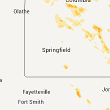
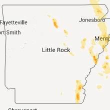
Hail Map for Monday, June 13, 2011

Number of Impacted Households on 6/13/2011
0
Impacted by 1" or Larger Hail
0
Impacted by 1.75" or Larger Hail
0
Impacted by 2.5" or Larger Hail
Square Miles of Populated Area Impacted on 6/13/2011
0
Impacted by 1" or Larger Hail
0
Impacted by 1.75" or Larger Hail
0
Impacted by 2.5" or Larger Hail


Cities Most Affected by Hail Storms of 6/13/2011
| Hail Size | Demographics of Zip Codes Affected | ||||||
|---|---|---|---|---|---|---|---|
| City | Count | Average | Largest | Pop Density | House Value | Income | Age |
| Sidney, NE | 4 | 1.75 | 1.75 | 18 | $61k | $34.3k | 38.2 |
| Cody, NE | 2 | 2.25 | 2.75 | 0 | $34k | $26.7k | 41.3 |
| Huxley, IA | 2 | 1.88 | 2.00 | 174 | $121k | $50.6k | 32.5 |
| Woodrow, CO | 2 | 1.75 | 1.75 | 1 | $83k | $31.6k | 43.3 |
| Owensville, MO | 1 | 2.75 | 2.75 | 32 | $74k | $34.4k | 43.0 |
| Merriman, NE | 1 | 2.75 | 2.75 | 0 | $30k | $26.6k | 47.3 |
| Nevada, IA | 1 | 2.00 | 2.00 | 71 | $94k | $43.2k | 38.6 |
| Mount Vernon, SD | 1 | 1.75 | 1.75 | 3 | $38k | $35.4k | 37.8 |
| Carpenter, SD | 1 | 1.75 | 1.75 | 1 | $34k | $31.8k | 41.5 |
| Mexico, MO | 1 | 1.75 | 1.75 | 67 | $67k | $33.0k | 38.9 |
| Lake Village, AR | 1 | 1.75 | 1.75 | 15 | $81k | $28.2k | 44.0 |
| Peetz, CO | 1 | 1.75 | 1.75 | 1 | $52k | $38.8k | 46.0 |
| Fulton, MO | 1 | 1.75 | 1.75 | 88 | $82k | $36.9k | 35.1 |
| Boonville, MO | 1 | 1.75 | 1.75 | 77 | $81k | $37.1k | 37.5 |
| Clear Lake, IA | 1 | 1.75 | 1.75 | 88 | $92k | $37.4k | 47.0 |
| Earlham, IA | 1 | 1.75 | 1.75 | 27 | $97k | $48.7k | 38.6 |
Hail and Wind Damage Spotted on 6/13/2011
Filter by Report Type:Hail ReportsWind Reports
States Impacted
Missouri, Nebraska, Iowa, Arkansas, Tennessee, South Dakota, Mississippi, Florida, Illinois, Colorado, South Carolina, Georgia, Louisiana, Kansas, Texas, North Dakota, MontanaMissouri
| Local Time | Report Details |
|---|---|
| 12:00 PM UTC | Golf Ball sized hail reported near Mexico, MO, 28.2 miles ENE of Columbia, MO |
| 12:01 PM UTC | Half Dollar sized hail reported near New Cambria, MO, 61.3 miles NNW of Columbia, MO |
| 12:31 PM UTC | Quarter sized hail reported near Fulton, MO, 24.2 miles ESE of Columbia, MO |
| 12:31 PM UTC | Golf Ball sized hail reported near Fulton, MO, 20.4 miles ESE of Columbia, MO |
| 12:33 PM UTC | Golf Ball sized hail reported near , , 20.9 miles ESE of Columbia, MO |
| 12:36 PM UTC | Quarter sized hail reported near Owensville, MO, 37.5 miles N of Salem, MO |
| 12:54 PM UTC | Quarter sized hail reported near Niangua, MO, 28.3 miles ENE of Springfield, MO |
| 12:55 PM UTC | Baseball sized hail reported near Owensville, MO, 36.8 miles N of Salem, MO, hail covering the ground...various sizes...largest observed was baseball sized |
| 1:14 PM UTC | Quarter sized hail reported near De Soto, MO, 46.5 miles SSW of Saint Louis, MO, lasted approximately 10 minutes |
| 1:14 PM UTC | Quarter sized hail reported near Arnold, MO, 15 miles SW of Saint Louis, MO, lasted approximately 10 minutes |
| 1:23 PM UTC | Quarter sized hail reported near Steelville, MO, 20.5 miles NNE of Salem, MO |
| 1:24 PM UTC | Quarter sized hail reported near Steelville, MO, 19.7 miles NNE of Salem, MO, cocorahs report |
| 1:53 PM UTC | Quarter sized hail reported near Boonville, MO, 22.4 miles W of Columbia, MO |
| 1:54 PM UTC | Golf Ball sized hail reported near Boonville, MO, 22.4 miles W of Columbia, MO |
| 1:56 PM UTC | Ping Pong Ball sized hail reported near Boonville, MO, 20.8 miles W of Columbia, MO |
| 2:28 PM UTC | Ping Pong Ball sized hail reported near Columbia, MO, 5.9 miles SW of Columbia, MO, hail size rapidly decreased to pea...near city limits of columbia |
| 2:36 PM UTC | Quarter sized hail reported near Columbia, MO, 0.3 miles SE of Columbia, MO, hail observed off of route k in south part of columbia |
| 3:13 PM UTC | Quarter sized hail reported near Ellington, MO, 41.4 miles SE of Salem, MO, storm accompanied by estimated winds in excess of 60 mph. numberous 5 to 6 inch tree limbs down. |
| 3:20 PM UTC | Half Dollar sized hail reported near Ellington, MO, 41.4 miles SE of Salem, MO |
| 5:14 PM UTC | Trees and power lines down. estimated 70-80 mph wind gust in dunklin county MO, 63.5 miles NNW of Memphis, TN |
| 5:16 PM UTC | Quarter sized hail reported near Novinger, MO, 53.9 miles WSW of Kahoka, MO |
| 5:20 PM UTC | Quarter sized hail reported near Cardwell, MO, 63.8 miles NNW of Memphis, TN |
| 8:34 PM UTC | Half Dollar sized hail reported near Bradleyville, MO, 36.3 miles SE of Springfield, MO |
| 8:35 PM UTC | Ping Pong Ball sized hail reported near Bradleyville, MO, 36.3 miles SE of Springfield, MO |
Nebraska
| Local Time | Report Details |
|---|---|
| 1:03 PM UTC | Quarter sized hail reported near West Point, NE, 61.5 miles NW of Omaha, NE |
| 11:17 PM UTC | Golf Ball sized hail reported near Cody, NE, 36 miles W of Valentine, NE, public reported golf ball sized hail and very heavy rain |
| 12:30 AM UTC | Quarter sized hail reported near Sidney, NE, 58.7 miles SE of Scottsbluff, NE, hail fell from 630 to 640 pm. |
| 12:30 AM UTC | Ping Pong Ball sized hail reported near Sidney, NE, 61.4 miles SE of Scottsbluff, NE |
| 12:31 AM UTC | Baseball sized hail reported near Cody, NE, 40.9 miles WSW of Valentine, NE, public reported baseball sized hail with home windows broken |
| 12:33 AM UTC | Golf Ball sized hail reported near Sidney, NE, 62 miles SE of Scottsbluff, NE |
| 12:36 AM UTC | Half Dollar sized hail reported near Sidney, NE, 62.6 miles SE of Scottsbluff, NE |
| 12:37 AM UTC | Half Dollar sized hail reported near Sidney, NE, 62 miles SE of Scottsbluff, NE |
| 12:38 AM UTC | Quarter sized hail reported near Merriman, NE, 47.4 miles SW of Valentine, NE |
| 12:40 AM UTC | Golf Ball sized hail reported near Sidney, NE, 62 miles SE of Scottsbluff, NE, law enforement reported many windows in sidney of cheyenne c |
| 12:40 AM UTC | Baseball sized hail reported near Merriman, NE, 48.8 miles SW of Valentine, NE |
| 12:45 AM UTC | The wind senser was attatched to his truc in cheyenne county NE, 65.3 miles SE of Scottsbluff, NE |
| 12:45 AM UTC | The wind sensor was attatched to his truc in cheyenne county NE, 65.3 miles SE of Scottsbluff, NE |
| 12:45 AM UTC | Quarter sized hail reported near Sidney, NE, 61.8 miles SE of Scottsbluff, NE, hail fell from 645 until 655 pm. |
| 12:45 AM UTC | Ping Pong Ball sized hail reported near Sidney, NE, 62 miles SE of Scottsbluff, NE |
| 12:45 AM UTC | Ping Pong Ball sized hail reported near Sidney, NE, 65.3 miles SE of Scottsbluff, NE, accumulations 1.5 to 2 inces deep along highway 30. |
| 12:45 AM UTC | Golf Ball sized hail reported near Sidney, NE, 66 miles SE of Scottsbluff, NE |
| 12:52 AM UTC | Quarter sized hail reported near Sidney, NE, 65.8 miles SE of Scottsbluff, NE |
| 1:00 AM UTC | Golf Ball sized hail reported near Sidney, NE, 63.9 miles SE of Scottsbluff, NE, hail fell from 700 until 710 pm. |
| 1:24 AM UTC | Quarter sized hail reported near Sidney, NE, 59 miles SE of Scottsbluff, NE |
| 1:31 AM UTC | Half Dollar sized hail reported near Sidney, NE, 64.4 miles SE of Scottsbluff, NE |
| 1:35 AM UTC | Quarter sized hail reported near Merriman, NE, 59.1 miles SW of Valentine, NE, mainly nickel sized hail with larger quarter size hailstones mixed in |
| 1:35 AM UTC | This gust was easterly and outflow from a squall line to the eas in sheridan county NE, 84.6 miles NE of Scottsbluff, NE |
Iowa
| Local Time | Report Details |
|---|---|
| 4:00 PM UTC | 8 inch diameter tree dow in guthrie county IA, 40.7 miles WNW of Des Moines, IA |
| 4:36 PM UTC | Off duty nws employee in dallas county IA, 13.3 miles W of Des Moines, IA |
| 5:25 AM UTC | Golf Ball sized hail reported near Earlham, IA, 27 miles WSW of Des Moines, IA |
| 5:55 AM UTC | Quarter sized hail reported near Bussey, IA, 46.4 miles SE of Des Moines, IA |
| 5:55 AM UTC | Quarter sized hail reported near Adel, IA, 18.9 miles W of Des Moines, IA |
| 7:17 AM UTC | Half Dollar sized hail reported near Huxley, IA, 22.8 miles N of Des Moines, IA |
| 7:20 AM UTC | Golf Ball sized hail reported near Huxley, IA, 21.4 miles N of Des Moines, IA |
| 7:25 AM UTC | Hen Egg sized hail reported near Huxley, IA, 20.7 miles N of Des Moines, IA |
| 7:35 AM UTC | Quarter sized hail reported near North English, IA, 40.6 miles SW of Cedar Rapids, IA |
| 7:45 AM UTC | Hen Egg sized hail reported near Nevada, IA, 30.9 miles NNE of Des Moines, IA |
| 10:00 AM UTC | Quarter sized hail reported near Pella, IA, 36.9 miles ESE of Des Moines, IA |
| 10:10 AM UTC | Golf Ball sized hail reported near Clear Lake, IA, 4.5 miles W of Mason City, IA |
| 11:08 AM UTC | Ping Pong Ball sized hail reported near Maxwell, IA, 24.1 miles NNE of Des Moines, IA |
Arkansas
| Local Time | Report Details |
|---|---|
| 4:34 PM UTC | Power lines down on highway 90 to the west of highway 13 in clay county AR, 86.4 miles NNW of Memphis, TN |
| 4:47 PM UTC | Trees blocking roads countywid in greene county AR, 72.9 miles NNW of Memphis, TN |
| 4:47 PM UTC | Trees blocking roads countywid in greene county AR, 72.4 miles NNW of Memphis, TN |
| 4:57 PM UTC | Trees down in paragoul in greene county AR, 67.9 miles NNW of Memphis, TN |
| 5:00 PM UTC | Tractor trailer overturned along u.s. highway 412 in greene county AR, 67.9 miles NNW of Memphis, TN |
| 5:00 PM UTC | Two brick buildings heavily damaged. awning removed from third buildin in greene county AR, 67.9 miles NNW of Memphis, TN |
| 5:00 PM UTC | Quarter sized hail reported near Marmaduke, AR, 76.9 miles NNW of Memphis, TN, law enforcement reports quarter size hail. |
| 5:12 PM UTC | Signs blown off of buildings...trees down countywid in craighead county AR, 53.6 miles NNW of Memphis, TN |
| 5:20 PM UTC | Windows blown out in one business and one hom in greene county AR, 67.9 miles NNW of Memphis, TN |
| 5:20 PM UTC | Tractor trailer truck blown over - mile marker 41 on interstate 55 in mississippi county AR, 32.5 miles N of Memphis, TN |
| 5:28 PM UTC | Power poles and lines down along highway 22 in craighead county AR, 58.4 miles NW of Memphis, TN |
| 5:29 PM UTC | Trees down countywid in mississippi county AR, 42.6 miles NNW of Memphis, TN |
| 5:35 PM UTC | Semi truck turned over in hwy 49 between marmaduke and paragould. trees blown over on shed in greene county AR, 74.2 miles NNW of Memphis, TN |
| 5:42 PM UTC | Trees down countywid in mississippi county AR, 42.6 miles NNW of Memphis, TN |
| 5:43 PM UTC | Severe damage to fire house. roof taken off house. trees and power lines dow in mississippi county AR, 41.3 miles NNW of Memphis, TN |
| 5:45 PM UTC | Tractor trailer truck blown over - mile marker 41 on interstate 55 in mississippi county AR, 32.5 miles N of Memphis, TN |
| 5:50 PM UTC | Severe damage to fire house. roof taken off house. trees and power lines dow in mississippi county AR, 41.3 miles NNW of Memphis, TN |
| 5:59 PM UTC | Spotter reports wind gust to 60 mp in cross county AR, 49 miles WNW of Memphis, TN |
| 6:00 PM UTC | Near richardson close to mississippi rive in mississippi county AR, 20.8 miles N of Memphis, TN |
| 6:13 PM UTC | Tractor trailer overturned on i-55 near mile marker 41. roof damag in mississippi county AR, 35.9 miles N of Memphis, TN |
| 6:15 PM UTC | A truck was blown over at mccror in woodruff county AR, 65.6 miles W of Memphis, TN |
| 6:50 PM UTC | Trees were downed in and around hunter...with some trees on power lines. power outages were noted in tow in woodruff county AR, 61.1 miles W of Memphis, TN |
| 7:35 PM UTC | A tree was down across military road. trees were also down across the east end of helen in phillips county AR, 53 miles SW of Memphis, TN |
| 7:40 PM UTC | Half Dollar sized hail reported near Big Flat, AR, 87.2 miles N of Little Rock, AR |
| 8:05 PM UTC | Half Dollar sized hail reported near Onia, AR, 80.8 miles N of Little Rock, AR |
| 8:30 PM UTC | Restaurant just north of wheatley had roof damage on trailer side of restauran in st. francis county AR, 62.2 miles WSW of Memphis, TN |
| 8:30 PM UTC | Ping Pong Ball sized hail reported near Timbo, AR, 77.3 miles N of Little Rock, AR |
| 9:45 PM UTC | Trees were downed in arkansas city...with some trees on house in desha county AR, 70.4 miles NE of Bastrop, LA |
| 10:10 PM UTC | Trees and powerlines down in the city. roof damage to building on 101 north shepard street. winds estimated to be 60 to 65 mph. power outages in dermott until 10 p in chicot county AR, 58.7 miles NNE of Bastrop, LA |
| 10:30 PM UTC | Numerous laerge trees down arounnd lake villag in chicot county AR, 52.5 miles NE of Bastrop, LA |
| 10:30 PM UTC | Numerous large trees down around lake villag in chicot county AR, 52.5 miles NE of Bastrop, LA |
| 10:35 PM UTC | Golf Ball sized hail reported near Lake Village, AR, 52.5 miles NE of Bastrop, LA, golf ball size hail around lake village |
| 10:40 PM UTC | Between lake village and eudora on highway 52...power poles snapped. on bill young road and ginny road...power poles snapped...trees down on houses...roofs blown off ho in chicot county AR, 50.1 miles NE of Bastrop, LA |
Tennessee
| Local Time | Report Details |
|---|---|
| 5:05 PM UTC | Winds estimated at 60 mph with large tree limbs down at intersection of union and quico in millingto in shelby county TN, 15.3 miles NE of Memphis, TN |
| 6:50 PM UTC | Prolonged northwest gusts to 75 mph with squall lin in shelby county TN, 13.5 miles E of Memphis, TN |
| 6:53 PM UTC | Thunderstorm wind gust reported by contract weather observer at memphis intl airpor in shelby county TN, 7.4 miles SSE of Memphis, TN |
| 6:55 PM UTC | Large tree down in yar in shelby county TN, 15.2 miles ESE of Memphis, TN |
| 6:55 PM UTC | Report of swirling winds and debris in hickory hill area going west of winchester and perkins with damage to roof of a bakery near lamar av in shelby county TN, 2.9 miles SSE of Memphis, TN |
| 7:05 PM UTC | Thunderstorm wind gust reported by contract weather observer at memphis intl airpor in shelby county TN, 7.4 miles SSE of Memphis, TN |
| 7:05 PM UTC | Thunderstorm wind gust reported by contract weather observer at memphis intl airpor in shelby county TN, 7.4 miles SSE of Memphis, TN |
| 7:11 PM UTC | Large tree blown down and completely blocking road at north parkway and montgomer in shelby county TN, 1.1 miles E of Memphis, TN |
| 7:22 PM UTC | Storm chaser reports 70 mph winds with hail to one inch along with large wall cloud just northwest of colliervill in shelby county TN, 21.8 miles ESE of Memphis, TN |
| 7:28 PM UTC | Second round of wind gusts near 75 mph with bookend vortex. winds shifted from northwest to eas in shelby county TN, 13.5 miles E of Memphis, TN |
South Dakota
| Local Time | Report Details |
|---|---|
| 6:45 PM UTC | Half Dollar sized hail reported near Plankinton, SD, 86 miles W of Sioux Falls, SD |
| 6:55 PM UTC | Half Dollar sized hail reported near Plankinton, SD, 86 miles W of Sioux Falls, SD, half dollar size hail continued for 10 minutes after earlier report. |
| 7:20 PM UTC | Ping Pong Ball sized hail reported near Plankinton, SD, 81.2 miles W of Sioux Falls, SD, walnut size hail has accumulated 3 inches. |
| 7:23 PM UTC | Golf Ball sized hail reported near Mt Vernon, SD, 80 miles W of Sioux Falls, SD |
| 8:10 PM UTC | Quarter sized hail reported near Letcher, SD, 70.7 miles WNW of Sioux Falls, SD |
| 10:55 PM UTC | Golf Ball sized hail reported near Carpenter, SD, 59.7 miles SSE of Aberdeen, SD |
| 1:40 AM UTC | Quarter sized hail reported near Hill City, SD, 22.4 miles W of Rapid City, SD |
| 1:47 AM UTC | Quarter sized hail reported near Nemo, SD, 15.3 miles WNW of Rapid City, SD |
Mississippi
| Local Time | Report Details |
|---|---|
| 6:53 PM UTC | Thunderstorm wind gust from fcwos observer at memphis intl airpor in desoto county MS, 16 miles SSW of Memphis, TN |
| 6:55 PM UTC | Report of swirling winds and debris in hickory hill area going west near winchester and perkins with damage to roof of baker in desoto county MS, 16 miles SSW of Memphis, TN |
| 6:57 PM UTC | Ping Pong Ball sized hail reported near Walls, MS, 14.5 miles SSW of Memphis, TN, quarter to ping pong size hail |
| 6:58 PM UTC | Small tree limbs dow in panola county MS, 44.2 miles S of Memphis, TN |
| 6:58 PM UTC | Olive branch airport. wind damage to hangers and planes overturne in desoto county MS, 18.5 miles SE of Memphis, TN |
| 7:05 PM UTC | At memphis intl fcwo in desoto county MS, 16 miles SSW of Memphis, TN |
| 7:05 PM UTC | At memphis intl fcwo in desoto county MS, 16 miles SSW of Memphis, TN |
| 7:11 PM UTC | Large tree blow down and completely blocking road at north parkway and montgomer in desoto county MS, 16 miles SSW of Memphis, TN |
| 7:25 PM UTC | *** 1 inj *** wind gust estimated at 95 mph occurred between 225 pm and 230 pm at the olive branch airport. damage to hangars resulted and planes were overturned. an ai in desoto county MS, 18.5 miles SE of Memphis, TN |
| 7:30 PM UTC | Trees down throughout tate count in tate county MS, 36.8 miles S of Memphis, TN |
| 7:40 PM UTC | *** 2 in panola county MS, 53.1 miles SSE of Memphis, TN |
| 7:45 PM UTC | Numerous trees down in the lula and moon lake area in coahoma county MS, 72.1 miles SSW of Memphis, TN |
| 7:45 PM UTC | Tractor trailer overturned on us 278 and ms hwy 6 just east of clarksdal in coahoma county MS, 72.1 miles SSW of Memphis, TN |
| 7:45 PM UTC | Tractor trailer overturned on hwy 49 toward helena bridge in coahoma county MS, 54.6 miles SSW of Memphis, TN |
| 8:40 PM UTC | *** 1 inj *** trees and power lines down in the northeast part of tallahatchie count in tallahatchie county MS, 71.2 miles S of Memphis, TN |
| 8:45 PM UTC | 60 mph winds 6 miles east of parchman on hwy 3 in tallahatchie county MS, 84.3 miles SSW of Memphis, TN |
| 8:50 PM UTC | Trees down across the road and powerlines. two homes also sustained some roof damag in calhoun county MS, 43.5 miles NW of Starkville, MS |
| 8:50 PM UTC | Trees down across the road and powerline in calhoun county MS, 39.5 miles NW of Starkville, MS |
| 9:00 PM UTC | Multiple trees downed in sunflower county MS, 96.3 miles SSW of Memphis, TN |
| 9:10 PM UTC | Numerous trees downed in the grenada area in grenada county MS, 61.4 miles WNW of Starkville, MS |
| 9:10 PM UTC | A large tree was downed across duncan rd near holcom in grenada county MS, 70.8 miles WNW of Starkville, MS |
| 9:15 PM UTC | Several trees down...some blocking roadways including highway 40 in montgomery county MS, 48.5 miles WNW of Starkville, MS |
| 9:30 PM UTC | Trees down across highway 17 in carroll county MS, 64 miles W of Starkville, MS |
| 9:30 PM UTC | Several trees and power lines downed countywide...canopies blown off of businesses in the city of eupora in webster county MS, 27.4 miles W of Starkville, MS |
| 9:30 PM UTC | Several trees down...two trees fell on houses in sunflower county MS, 88.7 miles NNW of Jackson, MS |
| 9:35 PM UTC | A couple trees downed...and power lines downed in sunflower county MS, 81.6 miles NNW of Jackson, MS |
| 9:35 PM UTC | A couple trees downed in sunflower county MS, 81.6 miles NNW of Jackson, MS |
| 9:35 PM UTC | Power line downed along road 2826 northeast of philadelphia in neshoba county MS, 44 miles SSW of Starkville, MS |
| 9:40 PM UTC | Trees down across highway 35 in carroll county MS, 55 miles W of Starkville, MS |
| 9:45 PM UTC | Power lines downed in sunflower county MS, 83.7 miles NNW of Jackson, MS |
| 9:50 PM UTC | Roof came off a grocery store and water has entered the buildin in choctaw county MS, 23.3 miles WSW of Starkville, MS |
| 9:50 PM UTC | Several trees and power lines down in holmes county...including along highway 12 and highway 1 in holmes county MS, 57.1 miles N of Jackson, MS |
| 10:05 PM UTC | Trees down on self creek in oktibbeha county MS, 0.6 miles SW of Starkville, MS |
| 10:10 PM UTC | Several trees down west of louisville in winston county MS, 30.4 miles SW of Starkville, MS |
| 10:10 PM UTC | Trees downed along ms highway 39 in kemper county MS, 54.9 miles S of Starkville, MS |
| 10:15 PM UTC | Trees and power lines downed in lowndes county MS, 24 miles E of Starkville, MS |
| 10:30 PM UTC | Numerous trees down in yazoo city in yazoo county MS, 40.9 miles NNW of Jackson, MS |
| 10:35 PM UTC | Power line downed along road 2826 northeast of philadelphia in neshoba county MS, 44 miles SSW of Starkville, MS |
| 10:50 PM UTC | Trees down...trees across roads and a tree on a house in the ludlow and branch communitie in scott county MS, 33.2 miles NE of Jackson, MS |
| 11:03 PM UTC | Tree down along meadow ridge drive and timber lane roa in madison county MS, 8.9 miles NNE of Jackson, MS |
| 11:05 PM UTC | Power poles were downed along spillway rd...causing a grass fir in rankin county MS, 13.1 miles NE of Jackson, MS |
| 11:15 PM UTC | Several trees down around morton in scott county MS, 30.7 miles E of Jackson, MS |
| 11:17 PM UTC | Power outages around bailey in lauderdale county MS, 71.7 miles S of Starkville, MS |
| 11:20 PM UTC | At trustmark park in pearl in rankin county MS, 3.1 miles SE of Jackson, MS |
| 11:20 PM UTC | Very large tree through the roof of a house in rankin county MS, 11.9 miles E of Jackson, MS |
| 11:20 PM UTC | Tree downed partially blocking i-20 westbound near mile marker 6 in rankin county MS, 14.8 miles E of Jackson, MS |
| 11:25 PM UTC | Storm damage reported in rankin county MS, 6.6 miles ESE of Jackson, MS |
| 11:35 PM UTC | Powerlines down across i-5 in hinds county MS, 6.2 miles SW of Jackson, MS |
| 11:45 PM UTC | Several trees down in western smith county including in raleigh and in polkvill in smith county MS, 42.9 miles ESE of Jackson, MS |
| 11:45 PM UTC | Tree downed on power line in jasper county MS, 58.8 miles ESE of Jackson, MS |
| 11:45 PM UTC | Power lines downed between bay springs and louin in jasper county MS, 56.2 miles ESE of Jackson, MS |
| 11:50 PM UTC | Several trees and some power lines downed across clarke county...power out in much of the city of quitman in clarke county MS, 84 miles W of Camden, AL |
| 11:50 PM UTC | Trees downed across the road along hwy 531 near hwy 18 in jasper county MS, 55.3 miles ESE of Jackson, MS |
| 11:58 PM UTC | Trees down around braxton...pinola and mendenhal in simpson county MS, 29.6 miles SE of Jackson, MS |
| 12:00 AM UTC | Tree blown onto a house causing an uncertain amount of damage in jones county MS, 75.6 miles ESE of Jackson, MS |
| 12:00 AM UTC | Trees down in town in jones county MS, 75.6 miles ESE of Jackson, MS |
| 12:00 AM UTC | Canopy blown off of a chicken plant loading doc in jasper county MS, 61.2 miles ESE of Jackson, MS |
| 12:00 AM UTC | Quarter sized hail reported near Sandersville, MS, 75.6 miles ESE of Jackson, MS |
| 12:03 AM UTC | Power lines down in sandersvill in jones county MS, 75.6 miles ESE of Jackson, MS |
| 12:03 AM UTC | Roof partially removed from a hous in jones county MS, 63.7 miles ESE of Jackson, MS |
| 12:25 AM UTC | Tree down on jones ford in the northwest part of the county in jefferson davis county MS, 40.4 miles SSE of Jackson, MS |
| 12:31 AM UTC | Trees and powerlines reported down on shady oak church road east of collin in covington county MS, 59.7 miles SE of Jackson, MS |
| 12:35 AM UTC | Trees were downed in silver creek in lawrence county MS, 49.3 miles SSE of Jackson, MS |
| 12:40 AM UTC | Tree down on airport road in jefferson davis county MS, 50.7 miles SSE of Jackson, MS |
| 1:00 AM UTC | Tree reported down on hinton drive in forrest county MS, 83.6 miles SE of Jackson, MS |
| 3:00 AM UTC | Numerous large tree limbs down...patio furniture blown around...garbage cans knocked over...and a vhf antenna blowned dow in jackson county MS, 26.1 miles W of Mobile, AL |
Florida
| Local Time | Report Details |
|---|---|
| 7:30 PM UTC | Canopy on gas station blown ove in levy county FL, 82 miles SW of Jacksonville, FL |
| 7:52 PM UTC | Quarter sized hail reported near Panama City, FL, 40.1 miles E of Miramar Beach, FL, dime to quarter size hail fell in the northern part of the county west of highway 77. a carport also sustained damamge. |
| 8:00 PM UTC | Quarter sized hail reported near Panama City, FL, 41.9 miles E of Miramar Beach, FL, a few quarter sized hail stones with more dime sized hail. |
| 8:25 PM UTC | Several small trees down on the north side of perry and spotter estimated 65 mph wind gus in taylor county FL, 47.7 miles ESE of Tallahassee, FL |
| 8:36 PM UTC | Stong wind gust 40 to 45 mph and pea size hail near regency square in duval county FL, 6.9 miles E of Jacksonville, FL |
| 4:45 PM EDT | Tree fell down on a car on arlington road near cesery boulevar in duval county FL, 3.4 miles E of Jacksonville, FL |
| 8:45 PM UTC | Pool awning on bassett lane was heavily damaged by wind in flagler county FL, 58.9 miles SSE of Jacksonville, FL |
| 4:52 PM EDT | Power lines are down on arlington road at lillian roa in duval county FL, 3.4 miles E of Jacksonville, FL |
| 8:55 PM UTC | Quarter sized hail reported near Palm Coast, FL, 58.9 miles SSE of Jacksonville, FL, dime to quarter size hail lasted for fifteen minutes at brenmar lane. |
| 9:05 PM UTC | Large limbs and damage to signs reported near beach blvd and kernan r in duval county FL, 10.3 miles ESE of Jacksonville, FL |
| 9:05 PM UTC | A large window was blown out at tom bush mazda on 9850 atlantic boulevar in duval county FL, 7 miles E of Jacksonville, FL |
| 9:05 PM UTC | Quarter sized hail reported near Palm Coast, FL, 58.9 miles SSE of Jacksonville, FL |
| 9:08 PM UTC | Power was knocked out for a large area of southwestern union count in union county FL, 57.1 miles WSW of Jacksonville, FL |
| 9:09 PM UTC | Wind gust to 60 mphkarge trees down at burning bush dr in flagler county FL, 59.6 miles SSE of Jacksonville, FL |
| 9:09 PM UTC | Quarter sized hail reported near Palm Coast, FL, 59.6 miles SSE of Jacksonville, FL, nickle to quarter size hail reported at burning bush dr |
| 9:10 PM UTC | Trees are down on homes on anniston roa in duval county FL, 7.8 miles ESE of Jacksonville, FL |
| 9:10 PM UTC | Skywarn spotter reports a large oak tree is down on anniston road near beach boulevard. pea to penny size hail was occurring along anniston road. he estimated winds of in duval county FL, 7.5 miles ESE of Jacksonville, FL |
| 9:20 PM UTC | Damage to the mcdonalds drive thru on southside boulevard just north of gate parkway caused by large tree limbs. trees damage also in thorton park arartment in duval county FL, 7 miles S of Jacksonville, FL |
| 9:30 PM UTC | Multiple reports of trees and limbs down in the indian trails and plm harbor subdivision in flagler county FL, 58.9 miles SSE of Jacksonville, FL |
| 9:30 PM UTC | Oak tree blown over on bunkerview drive in palm coas in flagler county FL, 58.9 miles SSE of Jacksonville, FL |
| 9:45 PM UTC | Quarter sized hail reported near Alachua, FL, 62.9 miles SW of Jacksonville, FL, large hail was reported on interstate 75 near the high springs us 441 exit. |
| 9:50 PM UTC | Quarter sized hail reported near High Springs, FL, 61.8 miles WSW of Jacksonville, FL, quarter size hail was reported along old bellamy |
| 11:11 PM UTC | Winds est to be 60 mph or higher at 127 drive north in jupiter farms in palm beach county FL, 25.7 miles SSE of Port Saint Lucie, FL |
| 7:15 PM EDT | Quarter sized hail reported near Palm Beach Gardens, FL, 27.9 miles SSE of Port Saint Lucie, FL, quarter size hail on bee line rd south of 706/indian town rd. exact location was unknown so location has been updated after a close analysis of radar data. |
| 11:15 PM UTC | Quarter sized hail reported near Jupiter, FL, 25.3 miles SSE of Port Saint Lucie, FL, quarter size hail on bee line rd south of 706/indian town rd |
| 11:39 PM UTC | Quarter sized hail reported near Milton, FL, 42.8 miles WNW of Miramar Beach, FL, public report of quarter size hail in bagdad. |
| 11:50 PM UTC | A downburst wind gust of 57 mph was measured at the jacksonville international airport. the downburst dropped directly over the airport comple in duval county FL, 10.7 miles NNW of Jacksonville, FL |
| 12:45 AM UTC | Top of barn blown off and on top of a vehicle at 6088 chumuckla hw in santa rosa county FL, 51 miles E of Mobile, AL |
Illinois
| Local Time | Report Details |
|---|---|
| 8:20 PM UTC | Several small branches down in adams county IL, 38.1 miles SSE of Kahoka, MO |
| 8:25 PM UTC | 8 inch diameter tree limb down at 13th and locust. relayed by wge in adams county IL, 38.1 miles SSE of Kahoka, MO |
| 8:26 PM UTC | Storm damage reported in adams county IL, 38.1 miles SSE of Kahoka, MO |
| 8:36 PM UTC | Storm damage reported in adams county IL, 43.1 miles SE of Kahoka, MO |
| 8:40 PM UTC | Power outages reported. also received pea size hai in adams county IL, 49.3 miles SE of Kahoka, MO |
| 9:19 PM UTC | Storm damage reported in pike county IL, 58.2 miles SSE of Kahoka, MO |
| 9:25 PM UTC | Approx 8 inch diameter tree limb blocking half of commercial street...from fire department in scott county IL, 70.5 miles NNW of Saint Louis, MO |
| 9:25 PM UTC | Large limb blown down...from county sheriff in scott county IL, 70.5 miles NNW of Saint Louis, MO |
| 5:08 AM UTC | Smaller limbs snapped ... 2 to 3 inch diamete in pike county IL, 61.4 miles SE of Kahoka, MO |
Colorado
| Local Time | Report Details |
|---|---|
| 9:00 PM UTC | Golf Ball sized hail reported near Woodrow, CO, 46.9 miles W of Yuma, CO |
| 10:37 PM UTC | Half Dollar sized hail reported near Anton, CO, 44.3 miles SW of Yuma, CO |
| 10:41 PM UTC | Quarter sized hail reported near Akron, CO, 40.3 miles SW of Yuma, CO |
| 11:11 PM UTC | Ping Pong Ball sized hail reported near Anton, CO, 42.3 miles SW of Yuma, CO |
| 11:37 PM UTC | Golf Ball sized hail reported near Woodrow, CO, 46 miles W of Yuma, CO |
| 1:11 AM UTC | Quarter sized hail reported near Peetz, CO, 61.5 miles NNW of Yuma, CO |
| 1:13 AM UTC | Golf Ball sized hail reported near Peetz, CO, 61.5 miles NNW of Yuma, CO |
| 1:19 AM UTC | Half Dollar sized hail reported near Crook, CO, 59.5 miles N of Yuma, CO |
| 1:22 AM UTC | Quarter sized hail reported near Peetz, CO, 62.5 miles NNW of Yuma, CO |
| 1:31 AM UTC | Half Dollar sized hail reported near Peetz, CO, 62.8 miles NNW of Yuma, CO, thunderstorm wind gust to 45 mph |
| 1:55 AM UTC | Quarter sized hail reported near Stoneham, CO, 68.4 miles S of Scottsbluff, NE |
| 2:19 AM UTC | Half Dollar sized hail reported near Peetz, CO, 62.5 miles NNW of Yuma, CO |
| 2:51 AM UTC | Quarter sized hail reported near Englewood, CO, 6.2 miles S of Denver, CO |
| 7:17 AM UTC | Quarter sized hail reported near Cope, CO, 33.9 miles SW of Yuma, CO |
South Carolina
| Local Time | Report Details |
|---|---|
| 10:15 PM UTC | Emergency management reported multiple large limbs down around hwy 11 and hwy 8 in and around pumpkintow in pickens county SC, 12 miles NNW of Greenville, SC |
| 4:40 AM UTC | Sumter county sheriff office reported severl trees down in the cherryvale are in sumter county SC, 60.8 miles NNW of Charleston, SC |
| 5:55 AM UTC | Tree down on dixie road near hwy 37 in williamsburg county SC, 29.1 miles NNE of Charleston, SC |
| 7:10 AM UTC | Numerous limbs down. some 3-4 inches in diamete in georgetown county SC, 54.5 miles ENE of Charleston, SC |
| 7:35 AM UTC | Tree down on 8th avenue sout in horry county SC, 66.1 miles ENE of Charleston, SC |
Georgia
| Local Time | Report Details |
|---|---|
| 10:40 PM UTC | The echols county emergency manager reported a downburst damaged the roofs on two homes with a tin roof completely removed. he also reports 50 to 100 trees blown down b in echols county GA, 59.6 miles SSW of Douglas, GA |
| 10:46 PM UTC | Tree down on a house and tore off the back side on j frank culpepper roa in echols county GA, 60.6 miles SSW of Douglas, GA |
Louisiana
| Local Time | Report Details |
|---|---|
| 11:20 PM UTC | Numerous trees downed includng power outage and a shed destroyed at intersection of louisiana highways 17 and 58 in west carroll county LA, 38.4 miles ENE of Bastrop, LA |
| 11:35 PM UTC | Tree downed on foster street behind jones grocer in east carroll county LA, 42.8 miles E of Bastrop, LA |
| 11:35 PM UTC | Several trees and power lines were downed across west carroll parish in west carroll county LA, 31.1 miles E of Bastrop, LA |
Kansas
| Local Time | Report Details |
|---|---|
| 11:35 PM UTC | Storm damage reported in sedgwick county KS, 5.4 miles NNW of Wichita, KS |
| 12:10 AM UTC | Delayed report. homeowners report having shingles blown off their roof. report came from the emergency managemen in butler county KS, 20.2 miles NE of Wichita, KS |
| 12:10 AM UTC | Emergency manager reports a large tree down across diamond roa in butler county KS, 20.2 miles NE of Wichita, KS |
Texas
| Local Time | Report Details |
|---|---|
| 12:35 AM UTC | Storm damage reported in presidio county TX, 21.8 miles W of Alpine, TX |
North Dakota
| Local Time | Report Details |
|---|---|
| 12:40 AM UTC | Storm damage reported in grand forks county ND, 66.6 miles E of Devils Lake, ND |
| 12:43 AM UTC | Top of trees snapped of in grand forks county ND, 66.6 miles E of Devils Lake, ND |
Montana
| Local Time | Report Details |
|---|---|
| 4:31 AM UTC | Storm damage reported in custer county MT, 0.5 miles ENE of Miles City, MT |
Connect with Interactive Hail Maps