

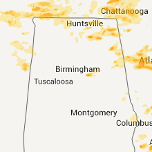
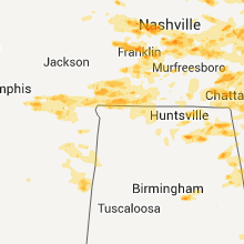
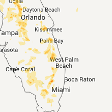
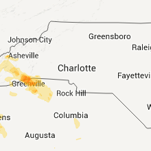
Hail Map for Wednesday, June 15, 2011

Number of Impacted Households on 6/15/2011
0
Impacted by 1" or Larger Hail
0
Impacted by 1.75" or Larger Hail
0
Impacted by 2.5" or Larger Hail
Square Miles of Populated Area Impacted on 6/15/2011
0
Impacted by 1" or Larger Hail
0
Impacted by 1.75" or Larger Hail
0
Impacted by 2.5" or Larger Hail


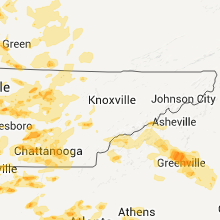


Cities Most Affected by Hail Storms of 6/15/2011
| Hail Size | Demographics of Zip Codes Affected | ||||||
|---|---|---|---|---|---|---|---|
| City | Count | Average | Largest | Pop Density | House Value | Income | Age |
| Nashville, TN | 4 | 2.06 | 2.50 | 1877 | $128k | $37.1k | 31.8 |
| Ider, AL | 3 | 2.42 | 2.75 | 90 | $64k | $28.3k | 41.1 |
| Hiram, GA | 3 | 1.75 | 1.75 | 791 | $107k | $50.7k | 34.7 |
| New Hope, AL | 2 | 2.13 | 2.50 | 95 | $78k | $35.0k | 40.2 |
| Douglasville, GA | 2 | 2.13 | 2.50 | 911 | $99k | $46.6k | 33.1 |
| Lake Butler, FL | 2 | 1.75 | 1.75 | 45 | $75k | $34.0k | 36.6 |
| Morgantown, KY | 2 | 1.75 | 1.75 | 31 | $61k | $29.8k | 39.6 |
| Olaton, KY | 1 | 2.50 | 2.50 | 17 | $62k | $29.0k | 44.5 |
| Greenwood, SC | 1 | 2.00 | 2.00 | 242 | $72k | $31.1k | 37.0 |
| Turtletown, TN | 1 | 2.00 | 2.00 | 59 | $73k | $23.0k | 44.9 |
| Indiantown, FL | 1 | 1.75 | 1.75 | 33 | $84k | $31.2k | 33.1 |
| Colquitt, GA | 1 | 1.75 | 1.75 | 21 | $0k | $0.0k | 41.5 |
| Savannah, TN | 1 | 1.75 | 1.75 | 57 | $70k | $27.2k | 42.2 |
| Fordyce, AR | 1 | 1.75 | 1.75 | 27 | $41k | $27.8k | 40.3 |
| North Platte, NE | 1 | 1.75 | 1.75 | 50 | $79k | $36.3k | 38.7 |
| Dresden, KS | 1 | 1.75 | 1.75 | 2 | $29k | $24.9k | 49.9 |
| Hayesville, NC | 1 | 1.75 | 1.75 | 45 | $104k | $31.0k | 50.2 |
| Buffalo, OK | 1 | 1.75 | 1.75 | 1 | $37k | $32.5k | 41.4 |
| Livingston, TN | 1 | 1.75 | 1.75 | 92 | $76k | $26.8k | 42.3 |
| Ivan, AR | 1 | 1.75 | 1.75 | 0 | $0k | $0.0k | 0.0 |
| Cedar Bluff, AL | 1 | 1.75 | 1.75 | 75 | $83k | $31.7k | 45.6 |
| Cookeville, TN | 1 | 1.75 | 1.75 | 426 | $94k | $28.6k | 33.0 |
| Wattsville, AL | 1 | 1.75 | 1.75 | 0 | $0k | $0.0k | 0.0 |
| Pine Bluff, AR | 1 | 1.75 | 1.75 | 196 | $64k | $35.5k | 39.4 |
| Chattanooga, TN | 1 | 1.75 | 1.75 | 1289 | $92k | $41.3k | 40.8 |
| Rison, AR | 1 | 1.75 | 1.75 | 19 | $53k | $34.1k | 39.5 |
| Leesburg, AL | 1 | 1.75 | 1.75 | 70 | $75k | $33.7k | 42.0 |
| Horse Branch, KY | 1 | 1.75 | 1.75 | 24 | $40k | $22.1k | 39.1 |
| Bainbridge, GA | 1 | 1.75 | 1.75 | 75 | $0k | $0.0k | 38.3 |
| Alachua, FL | 1 | 1.75 | 1.75 | 97 | $107k | $44.0k | 42.8 |
| Cartersville, GA | 1 | 1.75 | 1.75 | 428 | $100k | $43.8k | 35.6 |
| Soperton, GA | 1 | 1.75 | 1.75 | 29 | $58k | $24.8k | 36.9 |
Hail and Wind Damage Spotted on 6/15/2011
Filter by Report Type:Hail ReportsWind Reports
States Impacted
Kentucky, Tennessee, Arkansas, Alabama, Georgia, Florida, New York, Illinois, North Carolina, Missouri, South Carolina, Kansas, Indiana, Mississippi, Iowa, Montana, Utah, Wyoming, Oklahoma, NebraskaKentucky
| Local Time | Report Details |
|---|---|
| 3:48 PM UTC | Tree downed at us 68 and claunch roa in boyle county KY, 48 miles ESE of Louisville, KY |
| 4:10 PM UTC | Power lines down near sulphur wel in jessamine county KY, 33.5 miles WNW of Irvine, KY |
| 4:53 PM UTC | One tree down on glen-carin roa in wolfe county KY, 18.5 miles E of Irvine, KY |
| 9:15 PM UTC | Quarter sized hail reported near Whitesville, KY, 43.1 miles ESE of Evansville, IN |
| 9:22 PM UTC | Half Dollar sized hail reported near Whitesville, KY, 48.2 miles ESE of Evansville, IN, spotter estimated hail to be about half dollar sized |
| 9:50 PM UTC | Tennis Ball sized hail reported near Olaton, KY, 59.8 miles SE of Evansville, IN, spotter reported golf ball to tennis ball size hail along the ohio-grayson county border |
| 10:03 PM UTC | Golf Ball sized hail reported near Horse Branch, KY, 61.4 miles SE of Evansville, IN, occurred between 548pm and 603pm |
| 10:27 PM UTC | A few trees and powerlines down on ridge bay drive and gold point circle. reported by dispatc in barren county KY, 62 miles S of Louisville, KY |
| 10:53 PM UTC | Quarter sized hail reported near Greenville, KY, 61.4 miles SSE of Evansville, IN, quater inch hail and wind gusts 45 mph with the storm. |
| 10:55 PM UTC | Golf Ball sized hail reported near Morgantown, KY, 70.5 miles SE of Evansville, IN, report relayed from public of golf ball size hail |
| 10:55 PM UTC | Late report...straight-line wind damage near the intersection of hwy 171 and kenwood lane. one barn with 6x6 poles snapped and roof blown 100 yards away. several trees in muhlenberg county KY, 60.5 miles SSE of Evansville, IN |
| 11:00 PM UTC | Golf Ball sized hail reported near Morgantown, KY, 70.5 miles N of Nashville, TN, occurred between 652pm and 707pm |
| 11:03 PM UTC | Quarter sized hail reported near Cadiz, KY, 56.8 miles NE of Mc Kenzie, TN, quarter size hail reported at the intersection of hwys 139 and 164. |
| 11:33 PM UTC | Quarter sized hail reported near Bowling Green, KY, 67.7 miles N of Nashville, TN, report of dime to quarter size hail |
| 11:45 PM UTC | Half Dollar sized hail reported near Smiths Grove, KY, 68.5 miles NNE of Nashville, TN, reported quarter to half dollar size hail |
| 11:46 PM UTC | 18 inch diameter tree knocked down along with power lines in northern hancock county in hancock county KY, 41.3 miles E of Evansville, IN |
| 12:17 AM UTC | Quarter sized hail reported near Cloverport, KY, 51.1 miles WSW of Louisville, KY, nickel to quarter size hail reported |
| 12:20 AM UTC | 2 trees down in allen county KY, 53.1 miles NE of Nashville, TN |
| 12:38 AM UTC | Quarter sized hail reported near Fountain Run, KY, 59.4 miles NE of Nashville, TN, report relayed of quarter size hail |
| 12:53 AM UTC | Ping Pong Ball sized hail reported near McDaniels, KY, 47.3 miles SW of Louisville, KY |
| 1:13 AM UTC | Quarter sized hail reported near Clarkson, KY, 44 miles SW of Louisville, KY, quarter size hail reported |
Tennessee
| Local Time | Report Details |
|---|---|
| 3:59 PM UTC | Quarter sized hail reported near Carthage, TN, 47.1 miles E of Nashville, TN, spotter rpt quarter sized hail. |
| 4:50 PM UTC | One tree down on mt calvary r in marion county TN, 15 miles NW of Chattanooga, TN |
| 4:55 PM UTC | Quarter sized hail reported near Cookeville, TN, 70.9 miles E of Nashville, TN |
| 4:56 PM UTC | Golf Ball sized hail reported near Nashville, TN, 5 miles N of Nashville, TN |
| 4:59 PM UTC | Quarter sized hail reported near Baxter, TN, 61.4 miles E of Nashville, TN, quarter sized hail in double springs. |
| 12:05 PM CDT | Quarter sized hail reported near Nashville, TN, 0.2 miles NNW of Nashville, TN, spotter rpt quarter sized hail |
| 5:18 PM UTC | Golf Ball sized hail reported near Livingston, TN, 82.3 miles E of Nashville, TN, law enforcement rpt golf ball sized hail along hanging limb hwy in overton co. |
| 1:20 PM EDT | Quarter sized hail reported near Rockwood, TN, 43 miles W of Knoxville, TN |
| 5:22 PM UTC | Quarter sized hail reported near Crossville, TN, 65.4 miles W of Knoxville, TN |
| 5:35 PM UTC | Quarter sized hail reported near Chattanooga, TN, 7.2 miles ESE of Chattanooga, TN |
| 5:50 PM UTC | Several trees down countywide. reported by dispatc in loudon county TN, 29 miles WSW of Knoxville, TN |
| 6:00 PM UTC | One tree down on half moon road. reported by dispatc in anderson county TN, 22.3 miles WNW of Knoxville, TN |
| 6:15 PM UTC | Spotter believed winds caused by wet microburs in davidson county TN, 7.7 miles SE of Nashville, TN |
| 6:15 PM UTC | Quarter sized hail reported near Deer Lodge, TN, 53.8 miles WNW of Knoxville, TN |
| 6:55 PM UTC | Quarter sized hail reported near Dover, TN, 43.8 miles ENE of Mc Kenzie, TN, hail was observed on lick creek road |
| 7:16 PM UTC | Quarter sized hail reported near Crossville, TN, 63 miles N of Chattanooga, TN |
| 7:39 PM UTC | Quarter sized hail reported near Hohenwald, TN, 55.2 miles N of Florence, AL |
| 8:08 PM UTC | Quarter sized hail reported near Belle Meade, TN, 6.5 miles SW of Nashville, TN |
| 8:08 PM UTC | Trees down across the count in cheatham county TN, 17.5 miles WNW of Nashville, TN |
| 3:15 PM CDT | Tennis Ball sized hail reported near Nashville, TN, 4 miles S of Nashville, TN, observed at crieve hall in nashville |
| 3:20 PM CDT | Hen Egg sized hail reported near Nashville, TN, 0.2 miles NNW of Nashville, TN, hail occurred at harding road and interstate 24. |
| 8:22 PM UTC | Quarter sized hail reported near Nashville, TN, 10.2 miles NW of Nashville, TN |
| 8:25 PM UTC | Quarter sized hail reported near Saltillo, TN, 50.8 miles NW of Florence, AL |
| 8:30 PM UTC | Quarter sized hail reported near Savannah, TN, 42.9 miles NW of Florence, AL |
| 8:30 PM UTC | Two trees were knocked dow in hardin county TN, 42.9 miles NW of Florence, AL |
| 8:45 PM UTC | Quarter sized hail reported near Dunlap, TN, 22.9 miles NNW of Chattanooga, TN |
| 8:50 PM UTC | Trees down across much of northwestern rutherford count in rutherford county TN, 24.2 miles SE of Nashville, TN |
| 9:00 PM UTC | Half Dollar sized hail reported near Olive Hill, TN, 38.1 miles NNW of Florence, AL |
| 9:05 PM UTC | Trees down across the southern portion of the count in lewis county TN, 50 miles N of Florence, AL |
| 9:15 PM UTC | Trees down and some roof damage across western portion of the count in lawrence county TN, 34.4 miles NNE of Florence, AL |
| 9:23 PM UTC | Half Dollar sized hail reported near Harrison, TN, 14.1 miles NE of Chattanooga, TN, quarter to half dollar sized hail that the sequoyah nucler plantn and near hixson. |
| 4:25 PM CDT | Quarter sized hail reported near Pelham, TN, 34.4 miles WNW of Chattanooga, TN, observed at pelham |
| 9:25 PM UTC | Roof blown off of a home in lawrenceburg. trees down in and close to lawrencebur in lawrence county TN, 36.4 miles NNE of Florence, AL |
| 9:30 PM UTC | Golf Ball sized hail reported near Chattanooga, TN, 10.7 miles ENE of Chattanooga, TN, golf ball sized hail on highway 58. reported by spotter. |
| 9:38 PM UTC | Numerous trees...powerlines and power poles down on highway 58 between highway 68 and highway 30. reported by dispatc in meigs county TN, 48.1 miles NE of Chattanooga, TN |
| 9:40 PM UTC | Quarter sized hail reported near Cleveland, TN, 26.5 miles ENE of Chattanooga, TN, quarter sized hail in cleveland. reported by spotter. |
| 9:50 PM UTC | Quarter sized hail reported near Dickson, TN, 38.9 miles WSW of Nashville, TN |
| 9:55 PM UTC | Quarter sized hail reported near Columbia, TN, 36.3 miles SSW of Nashville, TN |
| 9:58 PM UTC | Quarter sized hail reported near Nashville, TN, 6 miles WSW of Nashville, TN, observed near charlotte pike and annex drive |
| 10:02 PM UTC | Quarter sized hail reported near Dickson, TN, 37.5 miles WSW of Nashville, TN |
| 5:05 PM CDT | Hen Egg sized hail reported near Nashville, TN, 0.2 miles NNW of Nashville, TN, 2 inch hail at mccabe golf course in downtown nashville. |
| 10:05 PM UTC | Hen Egg sized hail reported near Turtletown, TN, 54.1 miles E of Chattanooga, TN, hen egg sized hail in turtletown. reported by spotter. |
| 10:06 PM UTC | Quarter sized hail reported near Winchester, TN, 46.2 miles WNW of Chattanooga, TN |
| 10:07 PM UTC | Several trees down in and around pikeville. one on highway 30e and another on college street. reported by dispatc in bledsoe county TN, 39.3 miles N of Chattanooga, TN |
| 10:16 PM UTC | Trees were reported down on shelbyville highway and lynchburg highwa in lincoln county TN, 59.3 miles SSE of Nashville, TN |
| 10:18 PM UTC | Quarter sized hail reported near Signal Mountain, TN, 11.1 miles NNW of Chattanooga, TN, quarter sized hail in lone oak. reported by ema. |
| 10:20 PM UTC | Several trees and powerlines down in lone oak. reported by em in sequatchie county TN, 11.1 miles NNW of Chattanooga, TN |
| 10:27 PM UTC | A few trees and powerlines down on ridge bay drive and gold point c in hamilton county TN, 16.3 miles NE of Chattanooga, TN |
| 10:30 PM UTC | Trees were blown down on highway 5 in moore county TN, 62 miles WNW of Chattanooga, TN |
| 10:37 PM UTC | Trees reported down across the count in moore county TN, 61.6 miles WNW of Chattanooga, TN |
| 10:45 PM UTC | Several trees and powerlines down on highway 127 near miller cove road. reported by dispatc in sequatchie county TN, 12 miles NNW of Chattanooga, TN |
| 10:46 PM UTC | One tree down on highway 108. reported by dispatc in marion county TN, 17.9 miles NW of Chattanooga, TN |
| 10:47 PM UTC | Half Dollar sized hail reported near Waverly, TN, 40.9 miles E of Mc Kenzie, TN, half dollar size hail in waverly. |
| 11:20 PM UTC | Thunderstorm wind gust of 60 mph and half inch hail in far southwest dickson count in dickson county TN, 38.9 miles WSW of Nashville, TN |
| 11:20 PM UTC | A few trees and powerlines down on branston road and tallant road between collegedale and ooltewah. reported by dispatc in hamilton county TN, 17.1 miles E of Chattanooga, TN |
| 11:43 PM UTC | Golf Ball sized hail reported near Savannah, TN, 40.1 miles NW of Florence, AL, golf ball hail reported in the town of nixon. |
| 11:45 PM UTC | Ping Pong Ball sized hail reported near Milledgeville, TN, 52.6 miles S of Mc Kenzie, TN |
| 11:50 PM UTC | Trees and power lines down just southwest of town of counce near pickwick landin in hardin county TN, 37.4 miles WNW of Florence, AL |
| 11:55 PM UTC | Quarter sized hail reported near Loretto, TN, 27.3 miles NE of Florence, AL, quarter size hail 12 miles south of lawrenceburg. |
| 12:18 AM UTC | Half Dollar sized hail reported near Spring Hill, TN, 30.2 miles SSW of Nashville, TN, half dollar hail reported 2 miles east of spring hill. |
| 12:22 AM UTC | Quarter sized hail reported near Collinwood, TN, 26.4 miles N of Florence, AL, trees down and up to quarter size hail reported across southern portions of the county. |
| 12:35 AM UTC | Storm damage reported in lawrence county TN, 23.4 miles NE of Florence, AL |
| 12:45 AM UTC | Trees blown down and small hail in and near pulask in giles county TN, 45.8 miles NE of Florence, AL |
| 2:10 AM UTC | Quarter sized hail reported near Pleasant Shade, TN, 49.9 miles ENE of Nashville, TN, quarter size hail in pleasent shade. |
| 2:10 AM UTC | Half Dollar sized hail reported near Cookeville, TN, 70.9 miles E of Nashville, TN, half dollar hail reported 3 miles north of cookeville. |
| 2:50 AM UTC | Golf Ball sized hail reported near Cookeville, TN, 69.2 miles E of Nashville, TN, golfball size hail 2 miles west of cookeville. |
Arkansas
| Local Time | Report Details |
|---|---|
| 4:05 PM UTC | Tree limbs downed...along with half inch hail covering the groun in van buren county AR, 44.6 miles NNW of Little Rock, AR |
| 12:40 AM UTC | Golf Ball sized hail reported near Pine Bluff, AR, 43.6 miles SSE of Little Rock, AR, quarter to golfball sized hail was falling in southern jefferson county on highway 63 southeast of watsons chapel. |
| 1:00 AM UTC | Quarter sized hail reported near Pine Bluff, AR, 48.4 miles SSE of Little Rock, AR |
| 1:08 AM UTC | Quarter sized hail reported near Star City, AR, 61 miles SSE of Little Rock, AR |
| 1:15 AM UTC | Quarter sized hail reported near Star City, AR, 61 miles SSE of Little Rock, AR |
| 1:25 AM UTC | Golf Ball sized hail reported near Rison, AR, 55.3 miles SSE of Little Rock, AR, golfball sized hail damaged a vehicle. |
| 1:35 AM UTC | Quarter sized hail reported near Rison, AR, 54.7 miles SSE of Little Rock, AR |
| 1:54 AM UTC | Quarter sized hail reported near Rison, AR, 50.2 miles S of Little Rock, AR |
| 2:13 AM UTC | Quarter sized hail reported near Rison, AR, 58.6 miles S of Little Rock, AR |
| 2:45 AM UTC | Golf Ball sized hail reported near Ivan, AR, 59.2 miles S of Little Rock, AR, the dallas county sheriff reported golfball sized hail at ivan. |
| 3:26 AM UTC | Golf Ball sized hail reported near Fordyce, AR, 64.5 miles S of Little Rock, AR, golfball sized hail was reported by a sheriffs deputy at the highway 79 south junction in fordyce. |
Alabama
| Local Time | Report Details |
|---|---|
| 4:34 PM UTC | Half Dollar sized hail reported near Huntsville, AL, 61.9 miles E of Florence, AL, on ryland pike. hail lasted for 2 minutes. |
| 6:40 PM UTC | Quarter sized hail reported near New Hope, AL, 72.5 miles WSW of Chattanooga, TN |
| 6:43 PM UTC | Quarter sized hail reported near Owens Cross Roads, AL, 71.6 miles ESE of Florence, AL |
| 6:45 PM UTC | Quarter sized hail reported near New Hope, AL, 70.7 miles WSW of Chattanooga, TN |
| 6:45 PM UTC | Tennis Ball sized hail reported near New Hope, AL, 72.2 miles WSW of Chattanooga, TN |
| 6:49 PM UTC | Golf Ball sized hail reported near New Hope, AL, 72.2 miles WSW of Chattanooga, TN |
| 7:00 PM UTC | Quarter sized hail reported near Flat Rock, AL, 28.8 miles SW of Chattanooga, TN, one inch diamter hail was reported. |
| 7:13 PM UTC | Quarter sized hail reported near Grant, AL, 64.2 miles WSW of Chattanooga, TN |
| 7:36 PM UTC | Half Dollar sized hail reported near Pisgah, AL, 39.8 miles SW of Chattanooga, TN |
| 7:38 PM UTC | Quarter sized hail reported near Flat Rock, AL, 28.8 miles SW of Chattanooga, TN, one inch diameter hail was reported. |
| 7:52 PM UTC | Golf Ball sized hail reported near Leesburg, AL, 61.5 miles SSW of Chattanooga, TN, hail falling on county road 11. |
| 2:53 PM CDT | Baseball sized hail reported near Ider, AL, 30.7 miles SW of Chattanooga, TN, on county rd 778 near ider. golfball to baseball sized hail reported. |
| 7:53 PM UTC | Baseball sized hail reported near Ider, AL, 28.4 miles SW of Chattanooga, TN, on county rd 778 near ider. golfball to baseball sized hail reported. |
| 7:55 PM UTC | Golf Ball sized hail reported near Ider, AL, 25.7 miles SW of Chattanooga, TN |
| 8:03 PM UTC | Golf Ball sized hail reported near Cedar Bluff, AL, 57.9 miles SSW of Chattanooga, TN, golf ball size hail reported along county road 82. |
| 8:07 PM UTC | Quarter sized hail reported near Cedar Bluff, AL, 58.3 miles SSW of Chattanooga, TN, quarter size hail reported on county road 44. |
| 9:30 PM UTC | Quarter sized hail reported near Centre, AL, 66.6 miles S of Chattanooga, TN, quarter size hail in the community of forney. |
| 12:25 AM UTC | A tree was blown down on a hous in lauderdale county AL, 1.4 miles NNE of Florence, AL |
| 12:26 AM UTC | Quarter sized hail reported near Scottsboro, AL, 52.1 miles WSW of Chattanooga, TN, quarter size hail reported. |
| 12:40 AM UTC | A wind gust to 51 knots was reported at the muscle shoals asos sit in colbert county AL, 5.1 miles SE of Florence, AL |
| 12:54 AM UTC | A tree was blown down on cr 30 in dekalb county AL, 56 miles SW of Chattanooga, TN |
| 12:56 AM UTC | A tree was blown down near cr 289 and cr 307 in dekalb county AL, 56.3 miles SW of Chattanooga, TN |
| 12:58 AM UTC | A tree was blown down on cr 52 one half of a mile from highway 7 in dekalb county AL, 62.2 miles SW of Chattanooga, TN |
| 1:02 AM UTC | A tree was blown down on cr 11 in dekalb county AL, 41.5 miles SW of Chattanooga, TN |
| 1:07 AM UTC | Quarter sized hail reported near Fort Payne, AL, 50.2 miles SSW of Chattanooga, TN, quarter size hail reported |
| 1:08 AM UTC | Quarter sized hail reported near Hammondville, AL, 37 miles SSW of Chattanooga, TN, quarter size hail reported |
| 1:09 AM UTC | Tree down on powerlines on county road 57 near county road 69 in dekalb county AL, 56.4 miles SW of Chattanooga, TN |
| 1:15 AM UTC | Quarter sized hail reported near Athens, AL, 40.1 miles E of Florence, AL, quarter size hail was reported on lucas ferry road. |
| 1:15 AM UTC | Trees blown down in downtown athens on lucas ferry roa in limestone county AL, 40.1 miles E of Florence, AL |
| 1:28 AM UTC | A tree was blown down and the intersection of cr 46 and cr 2 in dekalb county AL, 62.6 miles SW of Chattanooga, TN |
| 1:40 AM UTC | Quarter sized hail reported near Huntsville, AL, 68 miles E of Florence, AL, quarter size hail reported. |
| 3:24 AM UTC | Quarter sized hail reported near Pell City, AL, 29.3 miles E of Birmingham, AL |
Georgia
| Local Time | Report Details |
|---|---|
| 5:35 PM UTC | Quarter sized hail reported near Rossville, GA, 4.7 miles SSE of Chattanooga, TN |
| 1:40 PM EDT | Quarter sized hail reported near Ringgold, GA, 7.7 miles SE of Chattanooga, TN, trained storm spotter reported quarter sized hail over catoosa county near the tennessee state line. |
| 7:55 PM UTC | Quarter sized hail reported near Rising Fawn, GA, 23.2 miles SW of Chattanooga, TN, pilot truck stop in rising fawn reported quarter sized hail fell with the storm. |
| 9:50 PM UTC | Half Dollar sized hail reported near Cedartown, GA, 60.2 miles WNW of Atlanta, GA |
| 9:59 PM UTC | Half Dollar sized hail reported near Dallas, GA, 27 miles NW of Atlanta, GA |
| 10:00 PM UTC | Quarter sized hail reported near Cedartown, GA, 52.6 miles WNW of Atlanta, GA |
| 6:00 PM EDT | Half Dollar sized hail reported near Kennesaw, GA, 23.5 miles NW of Atlanta, GA |
| 6:10 PM EDT | Forsyth county 911 relayed reports of 15-20 downed trees in and around forsyth. 15-20 powerlines were also reported downed...with 3-4 transformer fires. several house f in forsyth county GA, 34.9 miles NNE of Atlanta, GA |
| 10:10 PM UTC | Quarter sized hail reported near , , 22.1 miles NW of Atlanta, GA |
| 10:15 PM UTC | Half Dollar sized hail reported near Kennesaw, GA, 22.9 miles NW of Atlanta, GA |
| 6:22 PM EDT | Quarter sized hail reported near Cumming, GA, 34.9 miles NNE of Atlanta, GA |
| 10:24 PM UTC | Quarter sized hail reported near Dallas, GA, 25.7 miles NW of Atlanta, GA |
| 6:40 PM EDT | Golf Ball sized hail reported near Hiram, GA, 23.1 miles WNW of Atlanta, GA |
| 6:50 PM EDT | Quarter sized hail reported near Villa Rica, GA, 31.7 miles W of Atlanta, GA |
| 6:50 PM EDT | Half Dollar sized hail reported near Douglasville, GA, 24.7 miles W of Atlanta, GA |
| 10:55 PM UTC | Quarter sized hail reported near Powder Springs, GA, 20.5 miles WNW of Atlanta, GA |
| 6:55 PM EDT | Golf Ball sized hail reported near Douglasville, GA, 24.7 miles W of Atlanta, GA |
| 6:55 PM EDT | Tennis Ball sized hail reported near Douglasville, GA, 20.7 miles W of Atlanta, GA |
| 7:00 PM EDT | Ping Pong Ball sized hail reported near Douglasville, GA, 17.8 miles W of Atlanta, GA |
| 11:30 PM UTC | Quarter sized hail reported near Sandy Springs, GA, 12.5 miles N of Atlanta, GA, public reported quarter size hail just south of sandy springs. |
| 11:38 PM UTC | 911 call center relayed a report of numerous trees down across the count in gwinnett county GA, 22.7 miles ENE of Atlanta, GA |
| 11:52 PM UTC | Golf Ball sized hail reported near Bainbridge, GA, 29.6 miles NNW of Tallahassee, FL, many reports of hail around the county. largest estimated at golfball size. |
| 8:33 PM EDT | Half Dollar sized hail reported near Covington, GA, 32.3 miles ESE of Atlanta, GA |
| 12:38 AM UTC | Quarter sized hail reported near Canton, GA, 33 miles N of Atlanta, GA |
| 12:40 AM UTC | Trees and powerlines down in and around lincolnton in lincoln county GA, 36.1 miles NW of Augusta, GA |
| 12:43 AM UTC | Quarter sized hail reported near White, GA, 36.4 miles NNW of Atlanta, GA |
| 8:50 PM EDT | Golf Ball sized hail reported near Cartersville, GA, 37.4 miles NW of Atlanta, GA |
| 12:52 AM UTC | Trees dow in columbia county GA, 20.6 miles WNW of Augusta, GA |
| 8:53 PM EDT | Quarter sized hail reported near Cartersville, GA, 37.4 miles NW of Atlanta, GA |
| 1:00 AM UTC | Numerous trees and powerlines reported down across northern sections of the count in jasper county GA, 47.4 miles ESE of Atlanta, GA |
| 1:00 AM UTC | Trees down near soap creek bridge on indian road near us 22 in lincoln county GA, 31.3 miles NW of Augusta, GA |
| 1:01 AM UTC | Morgan county 911 relayed a report of a few trees down in the county. dispatch also reports power outages in four parts of the count in morgan county GA, 55 miles ESE of Atlanta, GA |
| 9:05 PM EDT | Golf Ball sized hail reported near Colquitt, GA, 58.2 miles NNW of Tallahassee, FL, reported near us 27 just north of colquitt |
| 1:10 AM UTC | Trees and powerlines down countywide in mcduffie county GA, 30.3 miles W of Augusta, GA |
| 1:10 AM UTC | Quarter sized hail reported near Kennesaw, GA, 22.9 miles NW of Atlanta, GA |
| 1:12 AM UTC | Wind gust of 58 knots..or 67 mph...measured at augusta bush field in richmond county GA, 6.8 miles S of Augusta, GA |
| 1:15 AM UTC | Quarter sized hail reported near Sylvester, GA, 59.2 miles W of Douglas, GA, hail up to quarter size reported in the isabella area |
| 1:20 AM UTC | Quarter sized hail reported near Cedartown, GA, 52.6 miles WNW of Atlanta, GA |
| 1:22 AM UTC | Numerous trees and powerlines down. one tree on a car. power out across the count in washington county GA, 59.3 miles SW of Augusta, GA |
| 1:22 AM UTC | 3 trees down across south newton count in newton county GA, 36.9 miles SE of Atlanta, GA |
| 1:24 AM UTC | Jefferson county 911 relayed a report of at least six trees down in the the county. most of the downed trees are located in wren in jefferson county GA, 30.3 miles SW of Augusta, GA |
| 1:30 AM UTC | Trees and power lines down in richmond county GA, 1.9 miles SW of Augusta, GA |
| 1:35 AM UTC | Trees down at hwys 23 and 80 in burke county GA, 22.1 miles S of Augusta, GA |
| 1:45 AM UTC | Quarter sized hail reported near Loganville, GA, 30.1 miles E of Atlanta, GA |
| 1:49 AM UTC | Trees down thompson bridge road area in burke county GA, 30 miles S of Augusta, GA |
| 2:00 AM UTC | 4 trees and 1 power line down in johnson county GA, 72.2 miles SW of Augusta, GA |
| 2:10 AM UTC | 3 trees down across south newton count in newton county GA, 36.9 miles SE of Atlanta, GA |
| 2:20 AM UTC | 2 trees down and 1 power line down in north alcovy are in jasper county GA, 40 miles SE of Atlanta, GA |
| 2:20 AM UTC | 911 reports several trees and several powerlines down across northern portions of the count in laurens county GA, 73.5 miles SW of Augusta, GA |
| 2:31 AM UTC | Quarter sized hail reported near Leesburg, GA, 82 miles N of Tallahassee, FL, reported near the intersection of us 82 and fussell road |
| 2:39 AM UTC | Johnson county fire department relayed a report of a few trees down in the scott area. also a nursing home was struck by lightning in scot in johnson county GA, 72.7 miles N of Douglas, GA |
| 2:55 AM UTC | Quarter sized hail reported near , , 34.5 miles NNW of Douglas, GA |
| 2:55 AM UTC | Report of several large trees down in yard on clito roa in bulloch county GA, 47.7 miles WNW of Savannah, GA |
| 3:02 AM UTC | 911 center relayed report of trees down on old dill roa in bulloch county GA, 58.6 miles NW of Savannah, GA |
| 3:03 AM UTC | Golf Ball sized hail reported near Soperton, GA, 65.1 miles NNE of Douglas, GA |
| 3:04 AM UTC | Crawford county 911 relayed reports of 6 downed tree in crawford county GA, 80 miles SSE of Atlanta, GA |
| 11:05 PM EDT | Golf Ball sized hail reported near Hiram, GA, 23.1 miles WNW of Atlanta, GA |
| 3:07 AM UTC | 911 center relayed report of trees and power lines down on zettwell r in bulloch county GA, 43.3 miles NW of Savannah, GA |
| 3:11 AM UTC | 911 center relayed report of downed power lines along highway 8 in bulloch county GA, 43.6 miles WNW of Savannah, GA |
| 11:16 PM EDT | Golf Ball sized hail reported near Hiram, GA, 23.1 miles WNW of Atlanta, GA |
| 3:17 AM UTC | Houston county 911 relayed reports of 5 downed tree in houston county GA, 82.2 miles NW of Douglas, GA |
| 3:20 AM UTC | 911 center relayed report of downed power lines along mud roa in bulloch county GA, 34.8 miles WNW of Savannah, GA |
| 3:25 AM UTC | 911 center relayed report of trees down on coley boyd roa in bulloch county GA, 48.4 miles WNW of Savannah, GA |
| 3:30 AM UTC | Quarter sized hail reported near Hawkinsville, GA, 77.7 miles NW of Douglas, GA |
| 3:30 AM UTC | Quarter sized hail reported near Hawkinsville, GA, 64.8 miles NNW of Douglas, GA |
| 3:45 AM UTC | Report of 1 tree down in higgsto in montgomery county GA, 54 miles NNE of Douglas, GA |
| 3:48 AM UTC | Public reported large oak tree down across hwy 29 in tattnall county GA, 60.2 miles W of Savannah, GA |
| 3:50 AM UTC | Cobb county emergency management reports a dozen down tree in cobb county GA, 14.9 miles WNW of Atlanta, GA |
| 3:50 AM UTC | Cobb county emergency management reports a dozen down tree in cobb county GA, 19.6 miles NW of Atlanta, GA |
| 3:50 AM UTC | Montgomery county emergency manager reports 2 downed trees on fire tower roa in montgomery county GA, 45.4 miles NNE of Douglas, GA |
| 3:55 AM UTC | Schley county 911 reports 2-3 downed trees in ellavill in schley county GA, 73 miles ESE of Auburn, AL |
| 3:56 AM UTC | 1 large oak tree blown down in kathlee in houston county GA, 81.8 miles NNW of Douglas, GA |
| 4:00 AM UTC | Tree down on highway 292 in tattnall county GA, 60.2 miles W of Savannah, GA |
| 4:00 AM UTC | Houston county 911 relayed reports of 10 downed trees in the count in houston county GA, 77 miles NW of Douglas, GA |
| 4:00 AM UTC | Laurens county 911 relayed reports of 3-4 downed trees and a few downed powerlines due to wind in laurens county GA, 67.2 miles N of Douglas, GA |
| 4:00 AM UTC | Houston county 911 relayed reports of 10 downed trees in the count in houston county GA, 80.6 miles NW of Douglas, GA |
| 4:03 AM UTC | Quarter sized hail reported near , , 35.3 miles NNW of Douglas, GA |
| 4:10 AM UTC | Webster county 911 relayed a report of a downed tre in webster county GA, 67.2 miles ESE of Auburn, AL |
| 4:15 AM UTC | Macon county 911 reports 2-3 downed tree in macon county GA, 87.4 miles ESE of Auburn, AL |
| 4:27 AM UTC | 9-inch tree limbs down with large tree limb on car. electricity out in the area. dime to penny sized hail also reporte in chatham county GA, 5.5 miles ESE of Savannah, GA |
| 4:30 AM UTC | Tree down in glennville in tattnall county GA, 50.2 miles W of Savannah, GA |
| 4:30 AM UTC | Wheeler county emergency management relayed reports of several downed trees on and around hwy 1 in wheeler county GA, 39.1 miles NNE of Douglas, GA |
| 4:42 AM UTC | Muscogee county 911 relayed reports of a downed tree and a downed powerline in columbu in muscogee county GA, 32.3 miles ESE of Auburn, AL |
| 4:54 AM UTC | Law enforcement reported a tree down on road near private branch church off hwy 30 in long county GA, 45.9 miles SW of Savannah, GA |
| 5:02 AM UTC | Light pole snapped off at the to in liberty county GA, 22.8 miles SW of Savannah, GA |
| 5:44 AM UTC | Emergency management reported a tree down on broadhurst road. time is estimated from rada in wayne county GA, 52 miles E of Douglas, GA |
| 6:10 AM UTC | Emergency management reported several trees down across northeastern brantley county. time is estimated from rada in brantley county GA, 62.6 miles E of Douglas, GA |
| 6:35 AM UTC | Numerous areas of tree and limb damage near the intersection of sea island road and frederica road. one pickup truck had a damaged back bed from a 12 inch diameter bran in glynn county GA, 60.7 miles NNE of Jacksonville, FL |
Florida
| Local Time | Report Details |
|---|---|
| 5:53 PM UTC | Quarter sized hail reported near Inverness, FL, 62 miles WNW of Orlando, FL, spotter reported half to one inch hail falling in downtown inverness. |
| 6:00 PM UTC | Quarter sized hail reported near Inverness, FL, 61.5 miles WNW of Orlando, FL, sheriffs office reported quarter sized hail ongoing since 2 pm |
| 6:33 PM UTC | Quarter sized hail reported near Lake Panasoffkee, FL, 48.9 miles WNW of Orlando, FL, trained spotter reported dime to quarter size hail. |
| 2:52 PM EDT | Quarter sized hail reported near Clermont, FL, 22.1 miles W of Orlando, FL, hail up to quarter-sized with estimated winds of 50-55 mph. |
| 7:10 PM UTC | Ksc 54 foot tower number 1605 measured 58 kt/67 mph wind gus in brevard county FL, 30.4 miles E of Orlando, FL |
| 3:31 PM EDT | Quarter sized hail reported near Cocoa, FL, 33 miles ESE of Orlando, FL, quarter-sized hail in the poinsett shores subdivision. |
| 3:45 PM EDT | Quarter sized hail reported near Auburndale, FL, 41.3 miles SW of Orlando, FL, public reported quarter size hail in auburndale near hwy 33 and i-4 |
| 7:45 PM UTC | Quarter sized hail reported near Dunnellon, FL, 74.8 miles WNW of Orlando, FL, trained spotter report of penny to quarter size hail 4 miles north of dunnellon. |
| 7:50 PM UTC | Asos reported 55 kt...63 mph wind gus in polk county FL, 41.3 miles SSW of Orlando, FL |
| 7:55 PM UTC | Quarter sized hail reported near Lake Alfred, FL, 37.6 miles SW of Orlando, FL, trained spotter reported quarter size hail in lake alfred. |
| 5:03 PM EDT | Quarter sized hail reported near Port St Lucie, FL, 9.9 miles WNW of Port Saint Lucie, FL |
| 5:45 PM EDT | Golf Ball sized hail reported near Indiantown, FL, 13.9 miles SW of Port Saint Lucie, FL, public report relayed through sheriffs office of golf ball size hail near martin hwy at fox brown rd. |
| 9:50 PM UTC | Multiple trees down. trees approx 3-4 inches in diameter and 7-8 ft tall. on martin hwy between fox brown rd and allapattah r in martin county FL, 12 miles SW of Port Saint Lucie, FL |
| 9:50 PM UTC | Multiple trees down. trees approx 3-4 inches in diameter and 7-8 ft tall. on martin hwy between fox brown rd and allapattah rd. time estimated by rada in martin county FL, 12 miles SW of Port Saint Lucie, FL |
| 10:20 PM UTC | Trees down in the hickory groove area northeast of madison and south-southeast of pinetta with possible roof damage. trampoline also wrapped around a tre in madison county FL, 58.9 miles E of Tallahassee, FL |
| 11:10 PM UTC | An oak and palm trees were reported down along highway 27 near the tropical market in clewisto in hendry county FL, 50.7 miles SW of Port Saint Lucie, FL |
| 11:30 PM UTC | 1.5 to 2 feet in diameter pines trees were reported down in the immokalee area. trees were also blown down and onto trailers and a car causing damag in collier county FL, 29.4 miles NE of Naples, FL |
| 11:35 PM UTC | Measured at golden gate fire station 7 in collier county FL, 12.6 miles ENE of Naples, FL |
| 11:40 PM UTC | Measured at golden gate fire station 7 in collier county FL, 6.6 miles ENE of Naples, FL |
| 11:45 PM UTC | Measured at hamilton harbor yacht club in naple in collier county FL, 0.3 miles WNW of Naples, FL |
| 11:45 PM UTC | Measured on roof of collier county emergency operations center. approximate height of instrument is 60 feet above ground. surface winds likely in 70-80 mph rang in collier county FL, 7.4 miles ESE of Naples, FL |
| 11:45 PM UTC | Estimated 60-70 mph winds with 2 inch branches broken off many tree in collier county FL, 3.5 miles E of Naples, FL |
| 11:45 PM UTC | Full sized trees downed on rattlesnake in collier county FL, 3.5 miles E of Naples, FL |
| 7:50 PM EDT | 911 call center reported trees down in ocal in marion county FL, 69.1 miles NW of Orlando, FL |
| 12:00 AM UTC | Numerous reports of tree branches and trees down across the naples-golden gate estates-immokalee areas. power lines reported down throughout naples and naples metro. ra in collier county FL, 0.3 miles WNW of Naples, FL |
| 12:00 AM UTC | Trees were blown down along 10896 se 131st lane. the time of damage was based on rada in marion county FL, 49.4 miles NW of Orlando, FL |
| 12:04 AM UTC | Storm damage reported in collier county FL, 8.5 miles SE of Naples, FL |
| 12:10 AM UTC | Measured at isle of capri fire statio in collier county FL, 11.7 miles SSE of Naples, FL |
| 12:20 AM UTC | Clay electric utility company reported scattered trees blown down into powerlines across western putnam and southeast alachua counties. tree damage was also noted in ma in marion county FL, 67.6 miles NNW of Orlando, FL |
| 12:25 AM UTC | Golf Ball sized hail reported near Lake Butler, FL, 53.5 miles WSW of Jacksonville, FL |
| 12:25 AM UTC | Golf Ball sized hail reported near Lake Butler, FL, 52.1 miles WSW of Jacksonville, FL |
| 12:25 AM UTC | Golf Ball sized hail reported near Alachua, FL, 56.3 miles WSW of Jacksonville, FL, spotter reported golf ball sized hail ssw of worthington springs. |
| 12:35 AM UTC | Thunderstorm winds blew down trees along 2750 se 49th avenue. the time of damage was based on rada in marion county FL, 60 miles NW of Orlando, FL |
| 12:55 AM UTC | Clay electric utility company reported scattered trees and large limbs down on powerlines. damage extended from southern bradford into northeast alachu in alachua county FL, 54.1 miles SW of Jacksonville, FL |
| 1:35 AM UTC | Scattered trees and tree limbs were blown down onto power lines across eastern alachua and norther marion county. the time of damage was based on radar imager in marion county FL, 68.3 miles SSW of Jacksonville, FL |
| 1:47 AM UTC | Trees were blown down along 10896 se 131st lan in marion county FL, 49.4 miles NW of Orlando, FL |
| 1:56 AM UTC | Thunderstorm winds blew down trees along 2750 se 49th avenu in marion county FL, 60 miles NW of Orlando, FL |
New York
| Local Time | Report Details |
|---|---|
| 7:42 PM UTC | Quarter sized hail reported near , , 33 miles WNW of Schenectady, NY |
Illinois
| Local Time | Report Details |
|---|---|
| 7:45 PM UTC | Quarter sized hail reported near Goreville, IL, 36.2 miles ENE of Cape Girardeau, MO, reported by police department. |
| 1:12 AM UTC | Power pole snapped off on mohawk roa in whiteside county IL, 76.9 miles NNW of Peoria, IL |
North Carolina
| Local Time | Report Details |
|---|---|
| 8:05 PM UTC | A fire fighter in the area around the perserve at chesnut flats said there are trees down across haywood county with a few houses being hit by falling trees. also power in haywood county NC, 55.7 miles ESE of Knoxville, TN |
| 8:45 PM UTC | Ping Pong Ball sized hail reported near Candler, NC, 49.1 miles N of Greenville, SC, report of 1.5 inch hail in the city of candler. |
| 9:03 PM UTC | Sheriff reported trees down in graham count in graham county NC, 44.6 miles S of Knoxville, TN |
| 9:20 PM UTC | Sheriff reported trees down in northern jackson count in jackson county NC, 51.1 miles NW of Greenville, SC |
| 9:21 PM UTC | Numerous trees and powerlines down. reported by dispatc in cherokee county NC, 52.7 miles S of Knoxville, TN |
| 9:25 PM UTC | Numerous trees reported down in silv in jackson county NC, 51.1 miles NW of Greenville, SC |
| 9:25 PM UTC | Multiple trees down off scotts creek r in jackson county NC, 51.2 miles NW of Greenville, SC |
| 9:30 PM UTC | Multiple trees down in franklin in macon county NC, 50.3 miles WNW of Greenville, SC |
| 9:30 PM UTC | Multiple trees down in jackson county NC, 51.1 miles NW of Greenville, SC |
| 5:34 PM EDT | Golf Ball sized hail reported near Hayesville, NC, 63 miles S of Knoxville, TN, dime to gold ball sized hail in hayesville. reported by dispatch. |
| 9:35 PM UTC | Radio station in waynesville reported 60 to 70 mph wind in haywood county NC, 50.1 miles NNW of Greenville, SC |
| 9:38 PM UTC | Numerous trees down in the tusquittee road and downings creek road areas. reported by dispatc in clay county NC, 62.7 miles S of Knoxville, TN |
| 10:03 PM UTC | Multiple trees down 4 miles south of etowa in henderson county NC, 29.6 miles N of Greenville, SC |
Missouri
| Local Time | Report Details |
|---|---|
| 8:15 PM UTC | Late report...wind gusts estimated 70 mph. dime size hail reported with this storm. bent flag pole. event occurred near country club along route 177 on north side of to in cape girardeau county MO, 2.6 miles N of Cape Girardeau, MO |
South Carolina
| Local Time | Report Details |
|---|---|
| 9:55 PM UTC | Numerous trees down along hwy 296 from anderson ridge rd to hwy 101. pieces of vinyl siding and in spartanburg county SC, 23.9 miles E of Greenville, SC |
| 10:25 PM UTC | Quarter sized hail reported near Travelers Rest, SC, 22.7 miles NE of Greenville, SC, 1 inch hail 2 miles north of tigerville. |
| 10:35 PM UTC | Trees down at lake cunningham...tree on house in greenville county SC, 19.8 miles NE of Greenville, SC |
| 10:37 PM UTC | Trees down at us 276 and bates crossing road in greenville county SC, 14.2 miles NNE of Greenville, SC |
| 10:47 PM UTC | A large tree fell on a house near the intersection of hammett bridge road and south buncombe road. visible damage to the house as the tree hit the corner and was lying in greenville county SC, 20.6 miles ENE of Greenville, SC |
| 10:47 PM UTC | Numerous trees down along ellison road and ellison circle. an area on ellison circle where the tops of a few trees were taken of in spartanburg county SC, 26.8 miles ENE of Greenville, SC |
| 10:48 PM UTC | Quarter sized hail reported near Greer, SC, 22.3 miles ENE of Greenville, SC, 1 inch hail reported near greenville-spartanburg airport along with flying debris |
| 10:48 PM UTC | Kgsp asos in spartanburg county SC, 22.3 miles ENE of Greenville, SC |
| 10:48 PM UTC | Wind gust to 60 mph reported by asos at greenville-spartanburg airport in greenville county SC, 22.3 miles ENE of Greenville, SC |
| 10:50 PM UTC | At least 9 oak trees uprooted in rolling greens villag in greenville county SC, 18.8 miles E of Greenville, SC |
| 6:50 PM EDT | Half Dollar sized hail reported near Lyman, SC, 26.8 miles ENE of Greenville, SC, hail larger than one inch in diameter reported on ellison circle. |
| 10:52 PM UTC | 8 inch limbs down on sc 357 near stewarts estate in greenville county SC, 22.3 miles ENE of Greenville, SC |
| 10:53 PM UTC | Quarter sized hail reported near Campobello, SC, 32.4 miles NE of Greenville, SC, one inch hail |
| 10:55 PM UTC | Half Dollar sized hail reported near Woodruff, SC, 27.9 miles E of Greenville, SC, up to half dollar sized hail in reidville. |
| 10:55 PM UTC | Numerous homes with shingles removed and siding ripped off along reidville road. at least 100 homes affected. similar damage in lyman and other parts of the count in spartanburg county SC, 27.9 miles E of Greenville, SC |
| 10:55 PM UTC | Multiple trees down in greenville county SC, 21.1 miles E of Greenville, SC |
| 10:55 PM UTC | Numerous trees down along hwy 296 from anderson ridge rd to hwy 101. pieces of vinyl siding and in spartanburg county SC, 23.9 miles E of Greenville, SC |
| 10:56 PM UTC | Multiple trees down at gsp airport in greenville county SC, 21.3 miles E of Greenville, SC |
| 11:00 PM UTC | Fence blown down...skirting blown off mobile home...roof peeled...and tree damag in spartanburg county SC, 33 miles E of Greenville, SC |
| 11:03 PM UTC | Multiple trees dow in spartanburg county SC, 34.7 miles E of Greenville, SC |
| 11:06 PM UTC | Numerous trees down in and around the city of anderso in anderson county SC, 21.6 miles S of Greenville, SC |
| 11:30 PM UTC | Multiple trees down blocking roads in union county SC, 48.7 miles ESE of Greenville, SC |
| 11:45 PM UTC | Trees and limbs down in santuc in union county SC, 56.3 miles SW of Charlotte, NC |
| 11:53 PM UTC | Tree limbs and powerlines down in whitmire in newberry county SC, 60.3 miles ESE of Greenville, SC |
| 11:54 PM UTC | Multiple trees down. time estimated by rada in abbeville county SC, 51.1 miles S of Greenville, SC |
| 12:00 AM UTC | Local grocery store employee saw many large tree limbs down across the area from the stor in chester county SC, 51.8 miles SW of Charlotte, NC |
| 12:03 AM UTC | Numerous trees and powerlines down and trees on cars newberry to whitmire in newberry county SC, 59.8 miles NNE of Augusta, GA |
| 12:05 AM UTC | Quarter sized hail reported near Greenwood, SC, 46.1 miles SE of Greenville, SC, several large limbs down. |
| 12:19 AM UTC | Hen Egg sized hail reported near Greenwood, SC, 50 miles NNW of Augusta, GA, time estimated by radar. |
| 12:23 AM UTC | Many trees down western part of fairfield count in fairfield county SC, 63.1 miles SSW of Charlotte, NC |
| 12:30 AM UTC | Multiple trees down reported county wid in saluda county SC, 37.8 miles NNE of Augusta, GA |
| 12:45 AM UTC | Trees and powerlines down northern end of mccormick county around mt carmel in mccormick county SC, 47.8 miles NW of Augusta, GA |
| 1:00 AM UTC | Trees and powerlines down around chapin in lexington county SC, 59.7 miles NE of Augusta, GA |
| 1:00 AM UTC | Trees down in plum branch area in mccormick county SC, 30.4 miles NNW of Augusta, GA |
| 1:02 AM UTC | Trees and powerlines down around blythewood in richland county SC, 69.6 miles S of Charlotte, NC |
| 1:02 AM UTC | Trees and powerlines down in edge in edgefield county SC, 21.6 miles N of Augusta, GA |
| 1:05 AM UTC | Trees and powerlines down around irmo in richland county SC, 61.8 miles NE of Augusta, GA |
| 1:10 AM UTC | Numerous trees down in the northeast columbia area. reported by sch in richland county SC, 73.5 miles ENE of Augusta, GA |
| 1:10 AM UTC | Trees and powerlines down around lexington in lexington county SC, 55.5 miles NE of Augusta, GA |
| 1:15 AM UTC | Sc highway patrol reported a tree in roadway at silver bluff landing off old jackson roa in aiken county SC, 10.9 miles SE of Augusta, GA |
| 1:15 AM UTC | Tree in roadway...mcmillian road and sandbar ferry road in aiken county SC, 4.4 miles E of Augusta, GA |
| 1:24 AM UTC | Wind gust measured at 53 knots...or 61 mph...at mcentire air national guard base in richland county SC, 68 miles NW of Charleston, SC |
| 1:28 AM UTC | Trees and power lines down. atomic roa in aiken county SC, 12.6 miles SE of Augusta, GA |
| 1:30 AM UTC | Sc highway patrol reported a tree down in the roadway at murph mill road and sweetwater lan in calhoun county SC, 60.5 miles WNW of Charleston, SC |
| 1:30 AM UTC | Trees down on bull swamp road in calhoun county SC, 58.2 miles ENE of Augusta, GA |
| 1:30 AM UTC | Power line down on goodland driv in orangeburg county SC, 39.6 miles E of Augusta, GA |
| 1:30 AM UTC | Trees down on dr. boyleton road in orangeburg county SC, 40.4 miles E of Augusta, GA |
| 1:30 AM UTC | Trees down on bull swamp road in calhoun county SC, 51.1 miles WNW of Charleston, SC |
| 1:34 AM UTC | South carolina highway patrol reported trees down at murph mill road and sweetwater lan in calhoun county SC, 60.5 miles WNW of Charleston, SC |
| 1:38 AM UTC | Trees and power lines dow in aiken county SC, 14.8 miles SE of Augusta, GA |
| 1:43 AM UTC | South carolina highway patrol reported trees down at furman field road and highway 44 in sumter county SC, 63.1 miles NNW of Charleston, SC |
| 2:00 AM UTC | South carolina highway patrol reported a tree down in the roadway at sc 300 and emerald lane in barnwell county SC, 41 miles ESE of Augusta, GA |
| 2:06 AM UTC | Sc highway patrol reported a tree down in the roadway at sc 3 and us 27 in barnwell county SC, 39.8 miles ESE of Augusta, GA |
| 2:09 AM UTC | Large trees down at hwy 125 and bluff rd. time estimated by rada in allendale county SC, 50.3 miles SE of Augusta, GA |
| 2:09 AM UTC | Large trees down at hwy 321 and williams rd. time estimated by rada in allendale county SC, 50.3 miles SE of Augusta, GA |
| 2:15 AM UTC | Trees and powerlines down in barnwell county SC, 38.7 miles ESE of Augusta, GA |
| 2:30 AM UTC | Trees down countywide in bamberg county SC, 56 miles ESE of Augusta, GA |
| 2:45 AM UTC | 25 trees down on property. tractor shed damage in allendale county SC, 53.4 miles ESE of Augusta, GA |
| 3:15 AM UTC | Public reported power lines down and on fire along hwy 21 towards beaufort...in the pristine are in beaufort county SC, 34.5 miles NE of Savannah, GA |
| 3:25 AM UTC | Off duty nws employee reported a large 10-12 foot diameter pine tree down on jacksonboro road in colleton county SC, 33.1 miles SW of Charleston, SC |
| 3:45 AM UTC | Public report of quarter size hail and large oak tree down on hudson mills roa in colleton county SC, 43 miles WSW of Charleston, SC |
| 3:45 AM UTC | Quarter sized hail reported near Walterboro, SC, 43 miles WSW of Charleston, SC, public report of quarter size hail and large oak tree down on hudson mills road. |
| 3:57 AM UTC | Report of 6 inch tree branches blown dow in beaufort county SC, 34.5 miles NE of Savannah, GA |
| 4:00 AM UTC | Public reported large trees dow in colleton county SC, 48.7 miles WSW of Charleston, SC |
| 4:05 AM UTC | Spotter reported a tree down in a wooded area. 55 mph wind gus in dorchester county SC, 20.5 miles SSW of Charleston, SC |
| 4:15 AM UTC | Public reported estimated 70mph wind gust. several large trees down and blown transformers on dorchester roa in dorchester county SC, 15.6 miles SW of Charleston, SC |
| 4:18 AM UTC | Tree down on a house on fort johnson road. time estimated based on rada in charleston county SC, 32.5 miles S of Charleston, SC |
Kansas
| Local Time | Report Details |
|---|---|
| 10:50 PM UTC | Half Dollar sized hail reported near Winona, KS, 42.8 miles SSW of Colby, KS |
| 11:24 PM UTC | Half Dollar sized hail reported near Jennings, KS, 42.6 miles ENE of Colby, KS, large hail fell for approximately 3 minutes. |
| 11:30 PM UTC | Golf Ball sized hail reported near Dresden, KS, 36 miles ENE of Colby, KS |
| 11:33 PM UTC | Half Dollar sized hail reported near Dresden, KS, 34.7 miles ENE of Colby, KS, encountered hail at intersection of ks highway 9 and 23. |
| 11:37 PM UTC | Half Dollar sized hail reported near Oberlin, KS, 37.2 miles ENE of Colby, KS |
| 1:30 AM UTC | The observer reported extensive blowing dust with the high wind in gray county KS, 30.7 miles E of Garden City, KS |
| 1:45 AM UTC | Storm damage reported in gray county KS, 35.4 miles ESE of Garden City, KS |
| 1:55 AM UTC | The wind was measured with a hand held anemomete in gray county KS, 35.7 miles SE of Garden City, KS |
| 3:10 AM UTC | Tree branches of 4 to 5 inches in diameter were broken and some power poles were dow in clark county KS, 61.9 miles SE of Garden City, KS |
Indiana
| Local Time | Report Details |
|---|---|
| 11:07 PM UTC | Damage to home and porch roofs at one residence. damage to one auto hit by large tree branches. damage to electrical weather hea in pike county IN, 32 miles NE of Evansville, IN |
| 11:23 PM UTC | Broken electric pole. missing road signs at intersection of state highway 62 and u.s. highway 231. cable transmission tower blown ove in spencer county IN, 34 miles ENE of Evansville, IN |
Mississippi
| Local Time | Report Details |
|---|---|
| 11:38 PM UTC | Trees down...shigles off of houses...and a metal porch was blown over due to straight line wind in tishomingo county MS, 36 miles WNW of Florence, AL |
| 11:55 PM UTC | Quarter sized hail reported near Walnut, MS, 66.6 miles ESE of Memphis, TN |
| 12:05 AM UTC | Quarter sized hail reported near Corinth, MS, 49.5 miles WNW of Florence, AL, quarter size hail at the intersection of highways 45 and 72. |
| 12:10 AM UTC | Quarter sized hail reported near Burnsville, MS, 36.9 miles W of Florence, AL, hail reported on n hwy 365 near burnsville |
| 12:26 AM UTC | Quarter sized hail reported near Falkner, MS, 66.7 miles ESE of Memphis, TN, hail lasted about 2 minutes and was 1 inch hail. |
Iowa
| Local Time | Report Details |
|---|---|
| 11:55 PM UTC | Quarter sized hail reported near Peosta, IA, 53.4 miles NE of Cedar Rapids, IA |
| 12:18 AM UTC | Quarter sized hail reported near , , 54.8 miles E of Cedar Rapids, IA, and heavy rain. |
| 12:21 AM UTC | Quarter sized hail reported near , , 54.8 miles E of Cedar Rapids, IA, quarter hail continues through 721 pm. heavy rain has produced minor street flooding as well. |
Montana
| Local Time | Report Details |
|---|---|
| 1:36 AM UTC | 30 to 40 foot live cottonwood tree snapped off at pioneer par in yellowstone county MT, 1.7 miles WNW of Billings, MT |
| 1:37 AM UTC | Storm damage reported in yellowstone county MT, 1.7 miles WNW of Billings, MT |
| 1:45 AM UTC | Numerous reports of large trees and branches down across billings causing power outages. downed trees and branches have also fallen on several vehicles. one particular in yellowstone county MT, 1.7 miles WNW of Billings, MT |
| 2:08 AM UTC | Quarter sized hail reported near Worden, MT, 18 miles NE of Billings, MT |
| 2:30 AM UTC | Storm damage reported in big horn county MT, 43.9 miles E of Billings, MT |
| 2:30 AM UTC | Winds blew over several fences in town and broke tree limbs. roof to the western motel was blown off in addition to several large trees being uprooted and many power li in big horn county MT, 43.5 miles E of Billings, MT |
| 2:30 AM UTC | Tops of trees and 8 inch limbs broken off in big horn county MT, 42.5 miles E of Billings, MT |
| 2:35 AM UTC | Power lines down in hardin in big horn county MT, 43.5 miles E of Billings, MT |
| 3:30 AM UTC | At the town pump gas station in rosebud county MT, 51.8 miles SW of Miles City, MT |
| 3:35 AM UTC | Badger peak raws in rosebud county MT, 60.9 miles SSW of Miles City, MT |
| 3:47 AM UTC | Sweeney creek dot in rosebud county MT, 24 miles WSW of Miles City, MT |
| 3:53 AM UTC | Storm damage reported in rosebud county MT, 36.6 miles SW of Miles City, MT |
| 4:05 AM UTC | Cow creek raws in custer county MT, 30.7 miles SSW of Miles City, MT |
| 4:09 AM UTC | Storm damage reported in custer county MT, 2.5 miles NW of Miles City, MT |
Utah
| Local Time | Report Details |
|---|---|
| 2:07 AM UTC | Storm damage reported in millard county UT, 55.2 miles NNW of Monroe, UT |
Wyoming
| Local Time | Report Details |
|---|---|
| 4:32 AM UTC | Sheridan asos in sheridan county WY, 79.5 miles WNW of Gillette, WY |
Oklahoma
| Local Time | Report Details |
|---|---|
| 4:38 AM UTC | Golf Ball sized hail reported near Buffalo, OK, 20.2 miles NW of Woodward, OK |
| 5:25 AM UTC | Half Dollar sized hail reported near Woodward, OK, 9.3 miles WSW of Woodward, OK, a trained spotter and kwtv-9 reported up to half dollar size hail on highway 412. a large tree limb was also blown down blocking the west bound lane of highway 412. |
| 5:30 AM UTC | Quarter sized hail reported near Woodward, OK, 6.7 miles W of Woodward, OK |
| 7:30 AM UTC | Resulted in power outages in kremli in garfield county OK, 76.3 miles NNW of Oklahoma City, OK |
| 8:04 AM UTC | Storm damage reported in noble county OK, 70.6 miles N of Oklahoma City, OK |
| 8:05 AM UTC | Storm damage reported in grant county OK, 65.9 miles SSW of Wichita, KS |
| 8:25 AM UTC | Storm damage reported in noble county OK, 65.3 miles WNW of Tulsa, OK |
| 9:45 AM UTC | Storm damage reported in creek county OK, 35.7 miles WSW of Tulsa, OK |
| 9:50 AM UTC | Storm damage reported in lincoln county OK, 42.4 miles ENE of Oklahoma City, OK |
| 10:54 AM UTC | Storm damage reported in muskogee county OK, 33.9 miles SE of Tulsa, OK |
Nebraska
| Local Time | Report Details |
|---|---|
| 10:00 AM UTC | Golf Ball sized hail reported near North Platte, NE, 14.9 miles S of North Platte, NE |
Connect with Interactive Hail Maps