

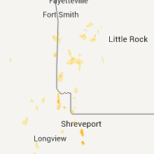
Hail Map for Friday, June 15, 2012

Number of Impacted Households on 6/15/2012
0
Impacted by 1" or Larger Hail
0
Impacted by 1.75" or Larger Hail
0
Impacted by 2.5" or Larger Hail
Square Miles of Populated Area Impacted on 6/15/2012
0
Impacted by 1" or Larger Hail
0
Impacted by 1.75" or Larger Hail
0
Impacted by 2.5" or Larger Hail


Cities Most Affected by Hail Storms of 6/15/2012
| Hail Size | Demographics of Zip Codes Affected | ||||||
|---|---|---|---|---|---|---|---|
| City | Count | Average | Largest | Pop Density | House Value | Income | Age |
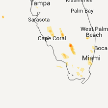
| Miami, FL | 3 | 1.83 | 2.00 | 6879 | $269k | $61.7k | 35.0 |
| Clewiston, FL | 1 | 2.75 | 2.75 | 24 | $71k | $33.3k | 33.1 |
Hail and Wind Damage Spotted on 6/15/2012
Filter by Report Type:Hail ReportsWind Reports
States Impacted
Florida, Colorado, South Dakota, Iowa, Arkansas, Texas, Louisiana, Tennessee, Mississippi, New Mexico, Oklahoma, North Dakota, KansasFlorida
| Local Time | Report Details |
|---|---|
| 2:41 PM EDT | Quarter sized hail reported near Boca Raton, FL, 44.3 miles N of Miami, FL, quarter sized hail reported by multiple trained spotters at boca raton. |
| 2:48 PM EDT | Ping Pong Ball sized hail reported near Boca Raton, FL, 44.3 miles N of Miami, FL, trained spotter reported 1 1/2in hail in boca raton. |
| 3:20 PM EDT | Hen Egg sized hail reported near Miami, FL, 2 miles W of Miami, FL, multiple reports of hail near in coral g |
| 3:20 PM EDT | Golf Ball sized hail reported near Miami, FL, 0.2 miles WNW of Miami, FL, golf ball sized hail reported at coconut grove. |
| 3:40 PM EDT | Trained spotter reported a 6ft tall tree uprooted near nw 31 s in broward county FL, 31 miles N of Miami, FL |
| 3:42 PM EDT | Quarter sized hail reported near Fort Lauderdale, FL, 31 miles N of Miami, FL, trained spotter reported quarter sized hail near i-95 and oakland park blvd. |
| 4:20 PM EDT | Quarter sized hail reported near Miami, FL, 3.7 miles NE of Miami, FL, off-duty nws employee reported quarter size hail near brickel ave. |
| 4:20 PM EDT | Golf Ball sized hail reported near Miami, FL, 0.2 miles WNW of Miami, FL, time of the event corrected...golf ball sized hail reported at coconut grove. |
| 4:35 PM EDT | Tree reported down and sign damaged along south highway 44 in okeechobee county FL, 26.6 miles W of Port Saint Lucie, FL |
| 5:48 PM EDT | Baseball sized hail reported near Clewiston, FL, 47.1 miles ENE of Naples, FL, baseball sized hail reported near sr 833 and sr 846 in hendry county. |
| 6:05 PM EDT | Quarter sized hail reported near Port Charlotte, FL, 44.4 miles SE of Bradenton, FL, quarter sized hail was reported at peachland blvd and harbor blvd in port charlotte. |
| 7:35 PM EDT | Quarter sized hail reported near Immokalee, FL, 29.9 miles ESE of Naples, FL |
Colorado
| Local Time | Report Details |
|---|---|
| 1:58 PM MDT | Quarter sized hail reported near Littleton, CO, 12.7 miles SSW of Denver, CO, mostly pea sized |
| 2:18 PM MDT | Quarter sized hail reported near Highlands Ranch, CO, 13.2 miles S of Denver, CO |
| 2:23 PM MDT | Half Dollar sized hail reported near Highlands Ranch, CO, 13.2 miles S of Denver, CO |
| 6:37 PM MDT | Ping Pong Ball sized hail reported near Seibert, CO, 57 miles S of Yuma, CO, near mile marker 400 along i-70. |
| 7:31 PM MDT | Storm damage reported in lincoln county CO, 55.4 miles ENE of Pueblo, CO |
South Dakota
| Local Time | Report Details |
|---|---|
| 2:30 PM MDT | 10 inch diameter tree limbs snapped off cottonwood tree in fall river county SD, 52.6 miles S of Rapid City, SD |
| 3:00 PM MDT | Quarter sized hail reported near Hot Springs, SD, 59.5 miles S of Rapid City, SD, a few large hailstones bounced off the pickup when traveling toward oelrichs. |
| 4:15 PM MDT | Quarter sized hail reported near Sturgis, SD, 31.4 miles NNE of Rapid City, SD |
| 4:18 PM MDT | Quarter sized hail reported near New Underwood, SD, 28.8 miles NE of Rapid City, SD, mostly dime hail with a few quarters from around 418 pm to 423 pm mdt. |
| 4:35 PM MDT | Wind gusts estimated at 60 to 70 mp in meade county SD, 50.4 miles NE of Rapid City, SD |
| 4:35 PM MDT | Storm damage reported in meade county SD, 36.6 miles NE of Rapid City, SD |
| 4:35 PM MDT | Quarter sized hail reported near Union Center, SD, 36.6 miles NE of Rapid City, SD, hail fell from 435 pm to 450 pm mdt. |
| 4:40 PM MDT | Half Dollar sized hail reported near Wall, SD, 60.1 miles ENE of Rapid City, SD, hail fell from 440 pm to 450 pm mdt...and was still hailing. |
| 5:00 PM MDT | Quarter sized hail reported near Wasta, SD, 41.2 miles ENE of Rapid City, SD, hail lasted from 500 pm to 525 pm mdt. did considerable crop damage. also had 30 to 40 mph winds. |
Iowa
| Local Time | Report Details |
|---|---|
| 4:03 PM CDT | Several six to eight inch limbs down. top of a large tree was sheared off. pea size hail also observe in calhoun county IA, 19.4 miles ESE of Storm Lake, IA |
| 4:31 PM CDT | Several large trees down across town. one tree fell on top of power lines knocking them to the ground. time estimated from rada in calhoun county IA, 27.1 miles ESE of Storm Lake, IA |
| 4:40 PM CDT | Tree branches down and heavy rain in pocahontas county IA, 18.5 miles ESE of Storm Lake, IA |
| 4:44 PM CDT | Several 6 inch limbs down across the yard. pea size hail also observed. time estimated from rada in pocahontas county IA, 19.5 miles E of Storm Lake, IA |
Arkansas
| Local Time | Report Details |
|---|---|
| 4:50 PM CDT | Quarter sized hail reported near Texarkana, AR, 39.4 miles S of Nashville, AR, quarter size hail near genoa. |
| 5:05 PM CDT | A resturante in the down town area had its tin roof peelled off due to strong thunderstorm wind in yell county AR, 60.7 miles WNW of Little Rock, AR |
| 5:05 PM CDT | Small limbs were reported down on ar hwy 155 between mt. nebo state park and dardanell in yell county AR, 62.2 miles WNW of Little Rock, AR |
| 5:14 PM CDT | Large tree limb down near the intersection of 5th street and 5th avenue in dardanell in yell county AR, 60.7 miles WNW of Little Rock, AR |
| 6:20 PM CDT | Quarter sized hail reported near De Queen, AR, 29 miles WNW of Nashville, AR |
| 6:25 PM CDT | Trees down near forema in little river county AR, 35.5 miles WSW of Nashville, AR |
Texas
| Local Time | Report Details |
|---|---|
| 5:30 PM CDT | Quarter sized hail reported near Marshall, TX, 35.2 miles W of Shreveport, LA |
| 5:30 PM CDT | Poweline and power poles downed in the city in harrison county TX, 35.2 miles W of Shreveport, LA |
| 5:34 PM CDT | Storage shed flipped on side on county road 4191 in hartburg. time estimated by rada in newton county TX, 12.5 miles NNW of Beaumont, TX |
| 6:43 PM CDT | Spotter reports power lines down near the town of simm in bowie county TX, 55.6 miles SW of Nashville, AR |
| 6:43 PM CDT | Quarter sized hail reported near Maud, TX, 55.6 miles SW of Nashville, AR, quarter size hail reported just east of simms |
| 6:53 PM CDT | Quarter sized hail reported near Alpine, TX, 7.5 miles SSE of Alpine, TX, mostly nickel size but a few quarter size. |
| 7:10 PM CDT | Report of a large tree down across highway 77 between atlanta and douglassville in cass county TX, 53.2 miles NNW of Shreveport, LA |
| 6:45 PM MDT | Storm damage reported in el paso county TX, 1.5 miles NNE of El Paso, TX |
| 6:50 PM MDT | Visibility also near zero with blowing dus in el paso county TX, 10.3 miles NNE of El Paso, TX |
| 9:00 PM CDT | Report from west texas mesonet site in castro county TX, 55.8 miles SSW of Amarillo, TX |
| 9:10 PM CDT | Schoolnet site reported gust in lamb county TX, 43.7 miles NNW of Lubbock, TX |
| 9:13 PM CDT | Schoolnet site reported gust in lamb county TX, 43.7 miles NNW of Lubbock, TX |
| 9:30 PM CDT | Tree reported down near highway 6 in cherokee county TX, 40.5 miles NW of Lufkin, TX |
| 9:47 PM CDT | Storm damage reported in lubbock county TX, 10.5 miles SW of Lubbock, TX |
| 10:25 PM CDT | West texas mesonet station in lubbock county TX, 16.4 miles SE of Lubbock, TX |
| 10:44 PM CDT | Ping Pong Ball sized hail reported near Dalhart, TX, 69.8 miles NNW of Amarillo, TX |
| 10:50 PM CDT | West texas mesonet in floyd county TX, 42.2 miles NE of Lubbock, TX |
| 11:05 PM CDT | West texas mesonet in crosby county TX, 39.7 miles E of Lubbock, TX |
| 1:05 AM CDT | West texas mesonet report. additional wind gusts of 58 and 62 mph at 1250 and 1255 am in castro county TX, 55.8 miles SSW of Amarillo, TX |
| 1:05 AM CDT | West texas mesonet report. gusts occured in the wake of dissipating thunderstorms. additional wind gusts of 58 mph at 1235 and 1250 and 62 mph at 1255 am in castro county TX, 55.8 miles SSW of Amarillo, TX |
| 2:20 AM CDT | West texas mesonet report in hale county TX, 19.3 miles NNE of Lubbock, TX |
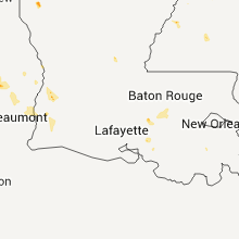
Louisiana
| Local Time | Report Details |
|---|---|
| 6:10 PM CDT | Quarter sized hail reported near Shreveport, LA, 4.3 miles SW of Shreveport, LA, quarter sized hail in south shreveport. |
| 6:10 PM CDT | Power lines down near frierso in de soto county LA, 22.4 miles S of Shreveport, LA |
| 6:15 PM CDT | Golf Ball sized hail reported near Shreveport, LA, 4.3 miles SW of Shreveport, LA, golf ball sized hail near byrd high school. |
| 6:25 PM CDT | Golf Ball sized hail reported near Shreveport, LA, 4.3 miles SW of Shreveport, LA |
| 6:30 PM CDT | Tree limbs down in caddo county LA, 37.6 miles NNW of Shreveport, LA |
| 6:35 PM CDT | Golf Ball sized hail reported near Bossier City, LA, 5.1 miles E of Shreveport, LA, golf ball sized hail at the boardwalk |
| 6:35 PM CDT | Golf Ball sized hail reported near Shreveport, LA, 4.3 miles SW of Shreveport, LA, golf ball sized hail in the highland area |
| 6:45 PM CDT | Large tree limb on a car near grimmet driv in caddo county LA, 4.3 miles SW of Shreveport, LA |
Tennessee
| Local Time | Report Details |
|---|---|
| 6:40 PM CDT | A power line was downed on mercury driv in rutherford county TN, 16.4 miles SE of Nashville, TN |
| 6:40 PM CDT | A tree fell on a house on scenic driv in rutherford county TN, 16.4 miles SE of Nashville, TN |
| 6:40 PM CDT | Damage occurred to two business...one at 304 sand hill road called swap diesel and to another business named crystal clean at 306 sand hill roa in rutherford county TN, 16.4 miles SE of Nashville, TN |
Mississippi
| Local Time | Report Details |
|---|---|
| 7:33 PM CDT | A couple trees and a power line were blown down in claiborne county MS, 52.4 miles WSW of Jackson, MS |
New Mexico
| Local Time | Report Details |
|---|---|
| 6:55 PM MDT | Storm damage reported in otero county NM, 29.2 miles NE of El Paso, TX |
| 12:30 AM MDT | Quarter sized hail reported near Portales, NM, 72.2 miles SSE of Tucumcari, NM |
Oklahoma
| Local Time | Report Details |
|---|---|
| 8:42 PM CDT | Emergency management reported a tree and power line down in potea in le flore county OK, 25.7 miles SSW of Fort Smith, AR |
| 8:42 PM CDT | Power pole/lines down vicinity of choctaw golf course off hwy 59 south side of potea in le flore county OK, 25.7 miles SSW of Fort Smith, AR |
North Dakota
| Local Time | Report Details |
|---|---|
| 10:17 PM CDT | Bismarck asos measured a peak wind gust of 61 mph with these storm in burleigh county ND, 2 miles SSE of Bismarck, ND |
Kansas
| Local Time | Report Details |
|---|---|
| 3:40 AM CDT | Quarter sized hail reported near Coldwater, KS, 61.1 miles N of Woodward, OK |
| 3:55 AM CDT | Storm damage reported in kiowa county KS, 81.3 miles N of Woodward, OK |
| 4:20 AM CDT | Storm damage reported in pratt county KS, 77 miles W of Wichita, KS |
| 4:53 AM CDT | Relayed via law enforcemen in kingman county KS, 60.1 miles W of Wichita, KS |
| 5:05 AM CDT | Large tree downed across arlington road west of streling road. time estimated per dopple in reno county KS, 52.2 miles WNW of Wichita, KS |
| 5:12 AM CDT | Relayed thru reno county emergency managemen in reno county KS, 32.1 miles WNW of Wichita, KS |
| 5:21 AM CDT | 65-70 mph. relayed through emergency managemen in reno county KS, 36.5 miles WNW of Wichita, KS |
| 5:26 AM CDT | Large limbs downed in hutchinso in reno county KS, 40.6 miles NW of Wichita, KS |
| 5:26 AM CDT | Hutchinson news reported several uprooted trees and power lines down in the block of hyde park and 20th street between jefferson and madison street in reno county KS, 42.7 miles NW of Wichita, KS |
| 5:30 AM CDT | Large tree reported down near 5th and empori in reno county KS, 28.4 miles WNW of Wichita, KS |
| 5:35 AM CDT | Storm damage reported in reno county KS, 28.4 miles WNW of Wichita, KS |
Connect with Interactive Hail Maps