

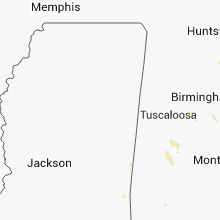
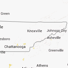
Hail Map for Wednesday, June 18, 2014

Number of Impacted Households on 6/18/2014
0
Impacted by 1" or Larger Hail
0
Impacted by 1.75" or Larger Hail
0
Impacted by 2.5" or Larger Hail
Square Miles of Populated Area Impacted on 6/18/2014
0
Impacted by 1" or Larger Hail
0
Impacted by 1.75" or Larger Hail
0
Impacted by 2.5" or Larger Hail


Cities Most Affected by Hail Storms of 6/18/2014
| Hail Size | Demographics of Zip Codes Affected | ||||||
|---|---|---|---|---|---|---|---|
| City | Count | Average | Largest | Pop Density | House Value | Income | Age |
| Big Springs, NE | 2 | 1.75 | 1.75 | 2 | $47k | $29.3k | 49.5 |
| Hershey, NE | 1 | 2.00 | 2.00 | 4 | $78k | $42.2k | 42.2 |
| Sutherland, NE | 1 | 1.75 | 1.75 | 3 | $74k | $38.9k | 40.6 |
| Belleville, PA | 1 | 1.75 | 1.75 | 91 | $81k | $32.0k | 35.5 |
| Paxton, NE | 1 | 1.75 | 1.75 | 2 | $55k | $30.8k | 43.4 |
| Orwell, OH | 1 | 1.75 | 1.75 | 70 | $97k | $39.0k | 34.7 |
| Pleasantville, PA | 1 | 1.75 | 1.75 | 29 | $60k | $33.9k | 45.6 |
| Bucklin, KS | 1 | 1.75 | 1.75 | 1 | $53k | $40.4k | 38.7 |
| Grandville, MI | 1 | 1.75 | 1.75 | 1491 | $135k | $51.4k | 36.1 |
Hail and Wind Damage Spotted on 6/18/2014
Filter by Report Type:Hail ReportsWind Reports
States Impacted
Wisconsin, South Dakota, Michigan, Maryland, Nebraska, North Carolina, Alabama, Indiana, Kentucky, South Carolina, Texas, Ohio, Georgia, Tennessee, Kansas, Pennsylvania, Illinois, Virginia, North Dakota, Colorado, Iowa, Minnesota, New JerseyWisconsin
| Local Time | Report Details |
|---|---|
| 7:00 AM CDT | A couple dozen of trees down 18 inches to 24 inches in diamete in sauk county WI, 44.2 miles NW of Madison, WI |
| 7:06 AM CDT | Tree down on interstate 94 eastbound at mile marker 75. trees also down on highway 80 between new lisbon and elroy...as well as near mauston. time estimated from rada in juneau county WI, 54.7 miles NNW of Madison, WI |
| 7:15 AM CDT | Trees down scattered about adams county but most concentrated across the central portion of the county. time estimated from rada in adams county WI, 59.9 miles NNW of Madison, WI |
| 7:21 AM CDT | Numerous trees down 18 inches to 24 inches in diamete in sauk county WI, 22.9 miles NW of Madison, WI |
| 7:21 AM CDT | Numerous trees down 18 inches to 24 inches in diamete in sauk county WI, 22 miles NW of Madison, WI |
| 7:40 AM CDT | Exterior walls of several floors of wi trade center heavily damaged. trees down in area in dane county WI, 6.5 miles WNW of Madison, WI |
| 7:40 AM CDT | Tree and minor house damag in dane county WI, 13.5 miles NNW of Madison, WI |
| 7:43 AM CDT | Small portion of roof damaged. numerous trees down in the neighborhood. delayed repor in dane county WI, 6.8 miles W of Madison, WI |
| 7:45 AM CDT | Numerous large damage trees uprooted and snapped...upper portion of side of home torn off...damage in narrow corridor...roads blocked with trees in dane county WI, 4.4 miles SW of Madison, WI |
| 8:00 AM CDT | Blown transformers...trees and power lines down in dane county WI, 9.5 miles E of Madison, WI |
| 8:00 AM CDT | Blown transformers...trees and powerlines down in dane county WI, 10.8 miles NE of Madison, WI |
| 8:00 AM CDT | 75-80 trees knocked down in dane county WI, 8.4 miles E of Madison, WI |
| 8:16 AM CDT | 40 foot shed lifted and thrown into neighboring field in dane county WI, 20.9 miles SE of Madison, WI |
| 8:33 AM CDT | Siding off houses...tree limbs down...heavy rain in dane county WI, 17.8 miles ENE of Madison, WI |
| 8:45 AM CDT | Large tree snapped about 2 feet off the ground...completely blocking roa in jefferson county WI, 43 miles E of Madison, WI |
| 8:48 AM CDT | Half Dollar sized hail reported near Whitewater, WI, 36.8 miles ESE of Madison, WI |
| 9:15 AM CDT | Trees snapped and uprooted...homes damaged in waukesha county WI, 58.2 miles E of Madison, WI |
South Dakota
| Local Time | Report Details |
|---|---|
| 6:25 AM MDT | Quarter sized hail reported near Milesville, SD, 56.3 miles W of Pierre, SD |
| 7:00 AM MDT | Storm damage reported in ziebach county SD, 49.1 miles WNW of Pierre, SD |
| 7:30 AM MDT | Quarter sized hail reported near Hayes, SD, 42.6 miles NW of Pierre, SD, hail covering ground ranging in size from peas to quarters. |
| 7:44 AM MDT | Quarter sized hail reported near Eagle Butte, SD, 44.2 miles NNW of Pierre, SD |
| 8:15 AM MDT | Quarter sized hail reported near Eagle Butte, SD, 46.5 miles NNW of Pierre, SD |
| 12:15 PM MDT | Half Dollar sized hail reported near Meadow, SD, 110.5 miles SW of Bismarck, ND |
| 1:33 PM MDT | Quarter sized hail reported near Watauga, SD, 84 miles SSW of Bismarck, ND, mostly pea size hail but a few up to quarter size |
| 1:47 PM MDT | Quarter sized hail reported near Isabel, SD, 84.9 miles SSW of Bismarck, ND, some quarter size hail but mostly smaller. 1.90 rain. |
| 4:48 PM CDT | Quarter sized hail reported near Herreid, SD, 73.3 miles WNW of Aberdeen, SD |
| 6:51 PM CDT | Dime hail with 60 mph wind gust in buffalo county SD, 72.4 miles ESE of Pierre, SD |
| 7:05 PM CDT | Peak wind measured at the sand lake raw in mcpherson county SD, 52.6 miles WNW of Aberdeen, SD |
| 8:48 PM CDT | Winds estimated over 60 mph. door blown in on bar in spink county SD, 34.5 miles S of Aberdeen, SD |
| 9:03 PM CDT | Storm damage reported in spink county SD, 20.7 miles S of Aberdeen, SD |
| 9:05 PM CDT | Peak wind measured at the brown county landfil in brown county SD, 6.5 miles W of Aberdeen, SD |
| 9:24 PM CDT | 60 to 70 mph win in brown county SD, 18.8 miles E of Aberdeen, SD |
| 9:40 PM CDT | Multiple 2 ft diameter trees down 2 miles east of bath...time estimated based by radar in brown county SD, 9.6 miles E of Aberdeen, SD |
| 5:00 AM CDT | Storm damage reported in day county SD, 39.5 miles ESE of Aberdeen, SD |
Michigan
| Local Time | Report Details |
|---|---|
| 9:00 AM EDT | Quarter sized hail reported near Byron Center, MI, 12.6 miles SSW of Grand Rapids, MI |
| 9:07 AM EDT | Golf Ball sized hail reported near Grandville, MI, 9.2 miles SW of Grand Rapids, MI |
| 9:13 AM EDT | Ping Pong Ball sized hail reported near Byron Center, MI, 10 miles SSW of Grand Rapids, MI |
| 9:15 AM EDT | Half Dollar sized hail reported near Byron Center, MI, 10.7 miles SSW of Grand Rapids, MI |
| 1:17 PM EDT | A tree fell in the road in front of 210 college ave ne in grand rapids. time estimated from rada in kent county MI, 0.6 miles ENE of Grand Rapids, MI |
| 1:22 PM EDT | Snapped and shredded trees on sir charles drive in rockfor in kent county MI, 11.9 miles NNE of Grand Rapids, MI |
| 1:35 PM EDT | A few large trees down in antwerp twp. time estimated from rada in van buren county MI, 52.5 miles S of Grand Rapids, MI |
| 1:35 PM EDT | A tree fell in front of a house on thompson drive in lowell. time estimated from rada in kent county MI, 17.8 miles E of Grand Rapids, MI |
| 1:39 PM EDT | A snapped tree blocked a driveway on lincoln lake road in lowel in kent county MI, 16.5 miles E of Grand Rapids, MI |
| 1:48 PM EDT | Downed tree blocking road near 2400 south 8th st. in oshtemo. time estimated from rada in kalamazoo county MI, 48.1 miles S of Grand Rapids, MI |
| 1:59 PM EDT | Tree blocking road at s 8th st. and w q ave. time estimated from rada in kalamazoo county MI, 52.9 miles S of Grand Rapids, MI |
| 2:00 PM EDT | Utility line and a single tree down in mendo in st. joseph county MI, 67 miles S of Grand Rapids, MI |
| 2:15 PM EDT | Multiple trees down in edwardsburg. time estimated from rada in cass county MI, 71.4 miles NW of Fort Wayne, IN |
| 2:15 PM EDT | Large tree down. half of an old barn demolished with wood driven into groun in ionia county MI, 32.1 miles E of Grand Rapids, MI |
| 2:20 PM EDT | Tree limbs and phone lines reported down in the 800 and 900 blocks on w michigan av in calhoun county MI, 49.8 miles SSE of Grand Rapids, MI |
| 2:30 PM EDT | Three trees down...two trees were on two vehicle in cass county MI, 67.5 miles NNW of Fort Wayne, IN |
| 2:58 PM EDT | Trees down over road. time estimated per rada in shiawassee county MI, 34.6 miles WSW of Flint, MI |
| 3:00 PM EDT | Tree down over road. time estimated per rada in shiawassee county MI, 28.5 miles W of Flint, MI |
| 3:14 PM EDT | Trees uprooted just south of the adrian airpor in lenawee county MI, 76.5 miles NE of Fort Wayne, IN |
| 3:14 PM EDT | Storm damage reported in lenawee county MI, 78.8 miles SSW of Flint, MI |
| 3:15 PM EDT | Tree down blocking norhtbound oakwood. relayed via social medi in lenawee county MI, 77.9 miles SSW of Flint, MI |
| 3:28 PM EDT | Downed power lines. time estimated per rada in livingston county MI, 30.7 miles SSW of Flint, MI |
| 3:43 PM EDT | Downed tree blocking road at bauer rd and cunningham lake rd. time estimated per radar in livingston county MI, 34.5 miles S of Flint, MI |
| 3:47 PM EDT | Power lines dow in genesee county MI, 11.2 miles S of Flint, MI |
| 3:50 PM EDT | Large tree limb down in genesee county MI, 6.5 miles SSE of Flint, MI |
| 3:56 PM EDT | Power line down on keene dr. burton... mi in genesee county MI, 4 miles SE of Flint, MI |
| 4:05 PM EDT | Large tree branches down blocking road on m50. time estimated per rada in monroe county MI, 76.5 miles S of Flint, MI |
| 4:10 PM EDT | 1 foot diamter tree down on south maple road. time estimated per rada in washtenaw county MI, 54.1 miles S of Flint, MI |
| 4:13 PM EDT | Multiple power lines down. cook and grandview and east coo in genesee county MI, 7.8 miles S of Flint, MI |
| 4:25 PM EDT | Power lines down at 15 mile and mound roads. time estimated per rada in macomb county MI, 45.4 miles SE of Flint, MI |
| 4:25 PM EDT | Estimated 12 inch tree limb down at the intersection of auburn rd and adams rd. time estimated per rada in oakland county MI, 35.7 miles SE of Flint, MI |
| 4:27 PM EDT | Estimated 8 inch tree snapped at base. time estimated per rada in oakland county MI, 43.9 miles SE of Flint, MI |
| 4:27 PM EDT | Downed tree on house at 1166 bradley. time estimated per rada in oakland county MI, 40.5 miles SE of Flint, MI |
| 4:27 PM EDT | 4 to 6 diameter tree limbs down on forge rd and 8 inch diameter limbs down on bellows rd. time estimated per rada in oakland county MI, 42.6 miles SE of Flint, MI |
| 4:48 PM EDT | 6 inch diameter tree downed at 11 mil in macomb county MI, 51.8 miles SE of Flint, MI |
Maryland
| Local Time | Report Details |
|---|---|
| 11:38 AM EDT | Tree down and blocking roadway in frederick county MD, 32.5 miles WNW of Baltimore, MD |
| 10:52 PM EDT | Lots of tree debris - some branches as big as 1.5 inches in diameter in baltimore county MD, 8.7 miles W of Baltimore, MD |
| 11:38 PM EDT | Tree down and blocking roadway in frederick county MD, 33.4 miles WNW of Baltimore, MD |
| 12:10 AM EDT | 30 foot tree was uprooted and picked up in carroll county MD, 18.5 miles WNW of Baltimore, MD |
| 12:24 AM EDT | Two large limbs downed in prince georges county MD, 40.1 miles SSW of Baltimore, MD |
| 12:28 AM EDT | Several 3 inch diameter branches down in baltimore county MD, 12.4 miles N of Baltimore, MD |
| 12:38 AM EDT | Andrews afb in prince georges county MD, 34.7 miles SSW of Baltimore, MD |
| 12:44 AM EDT | Trees down in croom area in prince georges county MD, 38.2 miles SSW of Baltimore, MD |
| 12:47 AM EDT | Half Dollar sized hail reported near Baltimore, MD, 2.7 miles N of Baltimore, MD |
| 12:48 AM EDT | Tree branches 3 to 4 inches in diameter are dow in baltimore county MD, 8.6 miles E of Baltimore, MD |
| 12:54 AM EDT | Quarter sized hail reported near Halethorpe, MD, 5.5 miles SW of Baltimore, MD |
| 1:10 AM EDT | Herring bay in anne arundel county MD, 38.9 miles S of Baltimore, MD |
| 1:19 AM EDT | Anne arundel cc in anne arundel county MD, 9 miles S of Baltimore, MD |
Nebraska
| Local Time | Report Details |
|---|---|
| 11:58 AM CDT | Storm damage reported in hayes county NE, 47.7 miles SSW of North Platte, NE |
| 6:42 PM MDT | Ping Pong Ball sized hail reported near Paxton, NE, 38.1 miles W of North Platte, NE |
| 6:45 PM MDT | Golf Ball sized hail reported near Paxton, NE, 35.7 miles W of North Platte, NE |
| 8:20 PM CDT | Golf Ball sized hail reported near Sutherland, NE, 24.1 miles W of North Platte, NE |
| 8:50 PM CDT | Half Dollar sized hail reported near Hershey, NE, 12.5 miles W of North Platte, NE |
| 8:50 PM CDT | Hen Egg sized hail reported near Hershey, NE, 12.4 miles W of North Platte, NE |
| 9:05 PM CDT | Quarter sized hail reported near Stapleton, NE, 26.1 miles NE of North Platte, NE |
| 9:25 PM CDT | Quarter sized hail reported near Arnold, NE, 32.8 miles ENE of North Platte, NE |
| 9:20 PM MDT | Quarter sized hail reported near Paxton, NE, 42.7 miles W of North Platte, NE |
| 9:40 PM MDT | Golf Ball sized hail reported near Big Springs, NE, 71.6 miles NNE of Yuma, CO, winds also estimated at 40mph |
| 9:55 PM MDT | Golf Ball sized hail reported near Big Springs, NE, 68.4 miles W of North Platte, NE, winds estimated at 50 to 60 mph |
| 10:20 PM MDT | Storm damage reported in chase county NE, 62.6 miles SW of North Platte, NE |
| 10:29 PM MDT | Storm damage reported in chase county NE, 62.6 miles SW of North Platte, NE |
| 11:58 PM CDT | Storm damage reported in hayes county NE, 47.7 miles SSW of North Platte, NE |
| 2:48 AM CDT | Storm damage reported in valley county NE, 57.5 miles NNW of Grand Island, NE |
North Carolina
| Local Time | Report Details |
|---|---|
| 1:01 PM EDT | Quarter sized hail reported near Franklin, NC, 50.3 miles WNW of Greenville, SC, up to 1 inch hail reported in franklin... nc. |
| 2:45 PM EDT | Quarter sized hail reported near Leicester, NC, 56.7 miles N of Greenville, SC |
| 3:30 PM EDT | Quarter sized hail reported near Connellys Springs, NC, 49.6 miles NW of Charlotte, NC, relayed by media. |
| 4:07 PM EDT | Quarter sized hail reported near Lincolnton, NC, 27.3 miles WNW of Charlotte, NC |
| 4:07 PM EDT | Two trees on house in lincoln county NC, 27.3 miles WNW of Charlotte, NC |
| 4:07 PM EDT | Trees down on power lines in lincoln county NC, 28.1 miles NW of Charlotte, NC |
| 4:12 PM EDT | A few trees down reported by a relative of a spotte in alexander county NC, 49.9 miles NNW of Charlotte, NC |
| 4:42 PM EDT | Siding damage to houses along with trees and limbs down on sterling pointe road in stokes county NC, 70.2 miles SSW of Roanoke, VA |
| 4:42 PM EDT | 6 to 8 trees down at old rt 52 and chestnut grove road in stokes county NC, 70.8 miles SSW of Roanoke, VA |
| 4:42 PM EDT | 2 to 3 trees down on midway roa in iredell county NC, 43 miles N of Charlotte, NC |
| 4:45 PM EDT | A tree was blown down onto powerlines on carson watts roa in stokes county NC, 69.3 miles SSW of Roanoke, VA |
| 6:05 PM EDT | A few trees down from a wind gust in stor in rowan county NC, 41.1 miles NE of Charlotte, NC |
| 6:50 PM EDT | Several power lines down from trees and limbs falling and perhaps one or two from lightning strikes at high rock lak in rowan county NC, 41.8 miles NE of Charlotte, NC |
Alabama
| Local Time | Report Details |
|---|---|
| 12:34 PM CDT | 30 ft by 100 ft outdoor metal building had roof blown off. also dime size hail was reporte in marshall county AL, 66.2 miles NE of Birmingham, AL |
| 12:45 PM CDT | Tree fell on power lines at guntersville state park in marshall county AL, 65.2 miles NNE of Birmingham, AL |
| 1:40 PM CDT | Limbs and trees down on herbert street. one tree fell on a house and another fell on a ca in marengo county AL, 47.9 miles NW of Camden, AL |
| 6:07 PM CDT | Tree downed - time estimated from radar in marshall county AL, 61.1 miles NNE of Birmingham, AL |
| 6:12 PM CDT | Tree downed - time estimated from radar in marshall county AL, 64.4 miles NNE of Birmingham, AL |
Indiana
| Local Time | Report Details |
|---|---|
| 1:56 PM EDT | Tree down on county road in st. joseph county IN, 66.8 miles ESE of Chicago, IL |
| 2:10 PM EDT | Trees down in mishawaka in st. joseph county IN, 68.3 miles NW of Fort Wayne, IN |
| 2:15 PM EDT | Medium size tree dow in st. joseph county IN, 68.3 miles NW of Fort Wayne, IN |
| 2:20 PM EDT | *** 1 inj *** tree down on van. female driver suffered minor injur in st. joseph county IN, 65.4 miles NW of Fort Wayne, IN |
| 2:23 PM EDT | Numerous trees and utility lines down across much of eastern half of count in st. joseph county IN, 68.3 miles NW of Fort Wayne, IN |
| 2:25 PM EDT | Tree down on hous in elkhart county IN, 61.9 miles NW of Fort Wayne, IN |
| 2:29 PM EDT | Downed trees and power lines in elkhart in elkhart county IN, 61.9 miles NW of Fort Wayne, IN |
| 2:34 PM EDT | Estimated 60-65 mph wind in marshall county IN, 59.8 miles WNW of Fort Wayne, IN |
| 2:38 PM EDT | Large branches down on cr 15 north of cr 38. time estimated from rada in elkhart county IN, 52.7 miles NW of Fort Wayne, IN |
| 2:40 PM EDT | Large tree down on a car. time estimated from rada in elkhart county IN, 49.8 miles NW of Fort Wayne, IN |
| 2:42 PM EDT | Multiple trees down throughout the cit in elkhart county IN, 51.6 miles NW of Fort Wayne, IN |
| 2:45 PM EDT | Numerous trees and utility lines down in elkhart and across much of northern and western elkhart count in elkhart county IN, 61.9 miles NW of Fort Wayne, IN |
| 2:50 PM EDT | Two small pear trees blown dow in elkhart county IN, 49.7 miles NW of Fort Wayne, IN |
| 2:50 PM EDT | Multiple trees dow in lagrange county IN, 48 miles NNW of Fort Wayne, IN |
| 2:53 PM EDT | Tree down on wooster r in kosciusko county IN, 40.8 miles WNW of Fort Wayne, IN |
| 3:02 PM EDT | Utility lines down in milfor in kosciusko county IN, 45.4 miles WNW of Fort Wayne, IN |
| 3:11 PM EDT | Tree uprooted onto power lines in the dewart lake are in kosciusko county IN, 40.8 miles WNW of Fort Wayne, IN |
| 3:18 PM EDT | Utility lines down at 600 east and 100 sout in lagrange county IN, 40.3 miles NNW of Fort Wayne, IN |
| 3:20 PM EDT | Several reports of large limbs down on roads across count in lagrange county IN, 42.4 miles NNW of Fort Wayne, IN |
| 3:20 PM EDT | Small tree down at nws employee hous in noble county IN, 35.6 miles NW of Fort Wayne, IN |
| 3:30 PM EDT | Power lines down and a horse stall blown ove in steuben county IN, 35.1 miles N of Fort Wayne, IN |
| 3:45 PM EDT | Trees and utility lines down between corunna and butle in dekalb county IN, 27.2 miles NNE of Fort Wayne, IN |
| 4:00 PM EDT | Tree down on a house in butler in dekalb county IN, 27.2 miles NNE of Fort Wayne, IN |
| 4:05 PM EDT | Viewer reported healthy tree snapped in yard. estimated winds at time...50 mph. time is approximat in warren county IN, 76.6 miles NW of Indianapolis, IN |
| 4:15 PM EDT | Measured 60 mph just east of airport by spotter with handheld measuring devic in allen county IN, 6.1 miles WSW of Fort Wayne, IN |
| 4:20 PM EDT | Trees and utility lines down around coliseum and anthony blvd. time estimated from rada in allen county IN, 1.6 miles W of Fort Wayne, IN |
| 4:25 PM EDT | Medium size tree split with half on groun in allen county IN, 1.6 miles W of Fort Wayne, IN |
| 4:25 PM EDT | Large tree snapped at the bas in allen county IN, 2.4 miles NNW of Fort Wayne, IN |
| 4:49 PM EDT | Storm damage reported in adams county IN, 17.6 miles SSE of Fort Wayne, IN |
| 4:53 PM EDT | A single tree down 1 mile nw of decatur. relayed by van wert county em. time estimated from rada in adams county IN, 18.3 miles SSE of Fort Wayne, IN |
| 5:33 PM EDT | Tree down on interstate 70 west just past the airport. sent in from viewer with photograp in marion county IN, 9.1 miles WSW of Indianapolis, IN |
| 6:17 PM EDT | High tension lines down...insulators broken off the poles. time approximat in shelby county IN, 20.6 miles ESE of Indianapolis, IN |
| 6:17 PM EDT | Green tree branches up to 6 inches in diameter broken off in town and surrounding area. multiple dead trees down in tow in shelby county IN, 24.9 miles ESE of Indianapolis, IN |
| 6:17 PM EDT | One carport blown about 75 yards out into a farm field. time is approximat in shelby county IN, 15.9 miles ESE of Indianapolis, IN |
| 6:30 PM EDT | Shingles damaged on some roofs. several small tree limbs dow in hamilton county IN, 16.1 miles N of Indianapolis, IN |
| 6:37 PM EDT | Five 4 to 6-inch diameter tree limbs from trees estimated to be over 100 feet tall blown down from high u in henry county IN, 40.9 miles ENE of Indianapolis, IN |
| 6:40 PM EDT | Two trees down. one on wilkinson road and one at us 35 and charles roa in wayne county IN, 58.2 miles ENE of Indianapolis, IN |
| 6:40 PM EDT | Trees snapped or uprooted. lynn pd fd reporting tree has fallen on a house in randolph county IN, 67.2 miles ENE of Indianapolis, IN |
| 6:41 PM EDT | Rough approximation of location. multiple calls were received by dispatch about trees down that are large enough that chain saws are needed for clean up. power lines do in henry county IN, 42.4 miles E of Indianapolis, IN |
| 6:49 PM EDT | Large limb down in pershin in wayne county IN, 54.4 miles E of Indianapolis, IN |
| 8:46 PM CDT | Time estimated per rada in newton county IN, 53.1 miles SSE of Chicago, IL |
| 10:52 PM EDT | County dispatch reports trees down across multiple locations throughout the county in white county IN, 75.1 miles NNW of Indianapolis, IN |
| 10:57 PM EDT | Trees down near us 24 and cr 800 w in lake cicott. time estimated from rada in cass county IN, 71.3 miles NNW of Indianapolis, IN |
| 11:07 PM EDT | Estimated gusts of 50 to 60 mph for several minutes. power flickerin in tippecanoe county IN, 64.1 miles NW of Indianapolis, IN |
| 11:20 PM EDT | Spotter reported trees down on tecumseh bend road in carroll county IN, 62.5 miles NNW of Indianapolis, IN |
| 11:30 PM EDT | Tree down on power lines in miami county IN, 55.6 miles WSW of Fort Wayne, IN |
| 11:36 PM EDT | Storm damage reported in howard county IN, 49.2 miles N of Indianapolis, IN |
| 12:05 AM EDT | Quarter sized hail reported near Elwood, IN, 39 miles NNE of Indianapolis, IN, spotter report a very brief period of quarter size hail. |
| 4:27 AM EDT | Tree down on power line in grant county IN, 45.3 miles SSW of Fort Wayne, IN |
Kentucky
| Local Time | Report Details |
|---|---|
| 3:05 PM EDT | One tree dow in bell county KY, 46.2 miles NNE of Knoxville, TN |
South Carolina
| Local Time | Report Details |
|---|---|
| 3:12 PM EDT | Quarter sized hail reported near Duncan, SC, 27.1 miles ENE of Greenville, SC, up to 1 inch hail west of wellford... sc. |
| 4:11 PM EDT | Highway patrol has tree in roadway along parris bridge road and power lines down in the same area. radar has a velocity max near that location at 411 p in spartanburg county SC, 44 miles ENE of Greenville, SC |
| 4:17 PM EDT | Storm damage reported in spartanburg county SC, 47.4 miles ENE of Greenville, SC |
| 4:50 PM EDT | County reports one tree down on jonesville industrial roa in union county SC, 52.3 miles E of Greenville, SC |
| 5:15 PM EDT | Tree down on westland driv in york county SC, 23.5 miles WSW of Charlotte, NC |
| 5:15 PM EDT | Clover police department reports a tree blown down across faulkner road at neely roa in york county SC, 24.3 miles WSW of Charlotte, NC |
| 5:45 PM EDT | Numerous trees down around the city of yor in york county SC, 27.5 miles SW of Charlotte, NC |
Texas
| Local Time | Report Details |
|---|---|
| 2:36 PM CDT | Quarter sized hail reported near Muleshoe, TX, 66.7 miles NW of Lubbock, TX |
| 2:58 PM CDT | Half Dollar sized hail reported near Muleshoe, TX, 66.7 miles NW of Lubbock, TX |
| 3:25 PM CDT | Quarter sized hail reported near Muleshoe, TX, 62.8 miles NW of Lubbock, TX |
| 4:05 PM CDT | House lost roof near intersection of fm 314 and cr 3417 numerous power poles down along cr 3417 in henderson county TX, 80 miles ESE of Dallas, TX |
| 4:08 PM CDT | Quarter sized hail reported near Earth, TX, 54.3 miles NW of Lubbock, TX, abundant small hail of pea to marble size...with occasional hailstones to one inch |
| 7:08 PM CDT | Storm damage reported in deaf smith county TX, 27.3 miles SW of Amarillo, TX |
| 7:57 PM CDT | 60 mph winds and nickel hail reported on loop 250 and wadley in midlan in midland county TX, 20.2 miles ENE of Odessa, TX |
| 8:02 PM CDT | Storm damage reported in midland county TX, 12.5 miles ENE of Odessa, TX |
| 8:20 PM CDT | Quarter sized hail reported near Midland, TX, 20.2 miles ENE of Odessa, TX, pea to quarter size hail reported in grasslands near wadley drive. |
| 8:25 PM CDT | 11 travel trailers blown over in northwest midland in midland county TX, 20.2 miles ENE of Odessa, TX |
| 8:25 PM CDT | 11 travel trailers blown over in northwest midland in midland county TX, 20.2 miles ENE of Odessa, TX |
| 8:26 PM CDT | Spotter reports 1.5 inch diameter tree branches broken off due to wind in midland county TX, 19.5 miles NE of Odessa, TX |
| 8:27 PM CDT | Tractor trailer overturned from strong winds in midland county TX, 21.1 miles ENE of Odessa, TX |
| 8:30 PM CDT | 20 power poles blown down at yukon and grandview in odessa in ector county TX, 0.3 miles E of Odessa, TX |
| 8:35 PM CDT | A 5 foot diameter tree snapped and another was uprooted at the greenwood cemetary in midland county TX, 30.6 miles ENE of Odessa, TX |
| 12:46 AM CDT | Via the west texas mesonet in potter county TX, 14.1 miles NNW of Amarillo, TX |
| 2:30 AM CDT | West texas mesonet report in cochran county TX, 51.8 miles W of Lubbock, TX |
Ohio
| Local Time | Report Details |
|---|---|
| 3:41 PM EDT | Quarter sized hail reported near Toledo, OH, 88.7 miles ENE of Fort Wayne, IN |
| 3:50 PM EDT | Quarter sized hail reported near Toledo, OH, 86.7 miles ENE of Fort Wayne, IN |
| 4:00 PM EDT | Large tree blocking both lanes of road southwest of montpelier. time estimated from rada in williams county OH, 40.2 miles NE of Fort Wayne, IN |
| 4:01 PM EDT | Tree down across roa in williams county OH, 37.3 miles NE of Fort Wayne, IN |
| 4:35 PM EDT | Multiple trees down in wauseon. time estimated from rada in fulton county OH, 59.7 miles ENE of Fort Wayne, IN |
| 4:41 PM EDT | Utility pole snapped northeast of bryan. time estimated from rada in williams county OH, 42.9 miles NE of Fort Wayne, IN |
| 4:45 PM EDT | *** 1 inj *** tree down acr0ss road and on car at 424 and cr4 in henry county OH, 64.4 miles ENE of Fort Wayne, IN |
| 5:22 PM EDT | Numerous 18 diameter trees down. large tree fell on power line and took down power pol in huron county OH, 62.1 miles WSW of Cleveland, OH |
| 5:23 PM EDT | Numerous 18 diameter trees down. large tree fell on power line and took down power pol in huron county OH, 62.1 miles WSW of Cleveland, OH |
| 5:24 PM EDT | Trees down across central darke county in darke county OH, 65.2 miles N of Cincinnati, OH |
| 5:32 PM EDT | A large tree and a power line down northwest of pleasant hil in miami county OH, 67.4 miles N of Cincinnati, OH |
| 5:35 PM EDT | 2 power poles and numerous trees dow in hancock county OH, 85.9 miles NNW of Columbus, OH |
| 5:51 PM EDT | Storm damage reported in medina county OH, 34.7 miles SSW of Cleveland, OH |
| 5:55 PM EDT | Three large trees down in tiffi in seneca county OH, 80.4 miles N of Columbus, OH |
| 5:57 PM EDT | Three power poles dow in seneca county OH, 80.4 miles N of Columbus, OH |
| 6:00 PM EDT | 12-15 inch diameter trees down and blocking road in sandusky county OH, 64.1 miles W of Cleveland, OH |
| 6:00 PM EDT | Healthy 1 foot diameter tree down on hous in sandusky county OH, 76.3 miles W of Cleveland, OH |
| 6:20 PM EDT | Golf Ball sized hail reported near Orwell, OH, 43.1 miles E of Cleveland, OH |
| 6:25 PM EDT | Estimated 65 mph thunderstorm wind gus in lorain county OH, 21 miles W of Cleveland, OH |
| 6:28 PM EDT | Numerous trees down with power outage in lorain county OH, 21 miles W of Cleveland, OH |
| 6:29 PM EDT | Numerous trees and power lines dow in stark county OH, 42.8 miles S of Cleveland, OH |
| 6:32 PM EDT | 1.5 foot diameter healthy tree fell on a truc in lorain county OH, 21 miles W of Cleveland, OH |
| 6:39 PM EDT | 2 foot diameter tree dow in lorain county OH, 17.5 miles WSW of Cleveland, OH |
| 6:45 PM EDT | Multiple 8 inch diameter trees dow in stark county OH, 50.7 miles SE of Cleveland, OH |
| 6:52 PM EDT | Multiple 8 inch diameter trees down. one light pole dow in lorain county OH, 23.4 miles WSW of Cleveland, OH |
| 6:59 PM EDT | Multiple 6-8 inch diameter tree branches down and covering roa in richland county OH, 60.5 miles NNE of Columbus, OH |
| 7:10 PM EDT | Lots of branches down across mayfield. one large tree down and blocking the roa in cuyahoga county OH, 13.4 miles ENE of Cleveland, OH |
| 7:27 PM EDT | 2 foot diameter branch fell onto a hous in trumbull county OH, 38.2 miles ESE of Cleveland, OH |
| 7:29 PM EDT | Gym roof collapsed at a high schoo in geauga county OH, 23.1 miles E of Cleveland, OH |
| 7:34 PM EDT | Large healthy oak tree fell onto bar in geauga county OH, 31.8 miles E of Cleveland, OH |
| 7:46 PM EDT | Multiple trees down on 2nd street in coshocton county OH, 64.4 miles ENE of Columbus, OH |
| 7:46 PM EDT | Multiple trees down on 2nd street in coshocton county OH, 64.4 miles ENE of Columbus, OH |
| 7:55 PM EDT | Large limbs down at patterson and river par in montgomery county OH, 46.8 miles NNE of Cincinnati, OH |
| 8:05 PM EDT | One tree down on logan s in tuscarawas county OH, 71.2 miles S of Cleveland, OH |
| 8:05 PM EDT | One tree down with wires down on state route 416 in tuscarawas county OH, 68.7 miles SSE of Cleveland, OH |
| 8:31 PM EDT | Multiple trees down on state route 39 in carroll county OH, 63.9 miles W of Pittsburgh, PA |
| 8:48 PM EDT | Branhes down...one 6 inches in diameter. time estimated from rada in franklin county OH, 4.9 miles NNW of Columbus, OH |
| 9:01 PM EDT | Multiple trees down in columbiana county OH, 45.2 miles WNW of Pittsburgh, PA |
| 9:44 PM EDT | Many trees and power lines down in belmont county OH, 69.8 miles WSW of Pittsburgh, PA |
| 1:29 AM EDT | Storm damage reported in franklin county OH, 8.9 miles NNW of Columbus, OH |
Georgia
| Local Time | Report Details |
|---|---|
| 4:05 PM EDT | Four trees reported down on roads including hwy 411 and hwy 53 in the eastern part of the count in gordon county GA, 49.3 miles SE of Chattanooga, TN |
Tennessee
| Local Time | Report Details |
|---|---|
| 4:10 PM EDT | A few trees down near mobray pik in hamilton county TN, 18.1 miles NNE of Chattanooga, TN |
| 4:12 PM EDT | One tree down on old graysville r in rhea county TN, 32.1 miles NNE of Chattanooga, TN |
| 4:39 PM EDT | Tree down on lake view circl in rhea county TN, 35 miles NNE of Chattanooga, TN |
| 5:00 PM EDT | A few trees dow in rhea county TN, 35 miles NNE of Chattanooga, TN |
| 4:11 PM CDT | One tree down near cagel mtn...highway 11 in sequatchie county TN, 22.8 miles NNW of Chattanooga, TN |
| 5:59 PM EDT | One tree dow in mcminn county TN, 41.4 miles NE of Chattanooga, TN |
| 6:00 PM EDT | One tree dow in mcminn county TN, 48.8 miles NE of Chattanooga, TN |
| 6:09 PM EDT | One tree dow in mcminn county TN, 49.9 miles SW of Knoxville, TN |
Kansas
| Local Time | Report Details |
|---|---|
| 3:25 PM CDT | Quarter sized hail reported near Healy, KS, 45.1 miles NNE of Garden City, KS |
| 5:11 PM CDT | Quarter sized hail reported near Sublette, KS, 33.8 miles S of Garden City, KS |
| 5:55 PM CDT | Half Dollar sized hail reported near Grainfield, KS, 36.7 miles ESE of Colby, KS, report from previous storm that moved through. |
| 6:01 PM CDT | Quarter sized hail reported near Grainfield, KS, 38 miles ESE of Colby, KS, report relayed via social media |
| 6:13 PM CDT | Golf Ball sized hail reported near Bucklin, KS, 73.4 miles ESE of Garden City, KS |
| 6:48 PM CDT | Quarter sized hail reported near Grainfield, KS, 36.7 miles ESE of Colby, KS |
| 6:50 PM CDT | At 205 and c roads... a barn was destroyed in addition to 5 high voltage power lines. time estimated from rada in hodgeman county KS, 39.5 miles E of Garden City, KS |
| 6:53 PM CDT | Storm damage reported in hodgeman county KS, 41.7 miles E of Garden City, KS |
| 7:00 PM CDT | Ping Pong Ball sized hail reported near Minneola, KS, 53.5 miles ESE of Garden City, KS |
| 7:10 PM CDT | Storm damage reported in hodgeman county KS, 55.3 miles SSW of Hays, KS |
| 7:10 PM CDT | Quarter sized hail reported near Offerle, KS, 71.8 miles S of Hays, KS |
| 7:22 PM CDT | Quarter sized hail reported near Jetmore, KS, 54.7 miles ENE of Garden City, KS |
| 7:25 PM CDT | Quarter sized hail reported near Jetmore, KS, 53 miles SW of Hays, KS |
| 8:20 PM CDT | Quarter sized hail reported near Lenora, KS, 53.3 miles NNW of Hays, KS, 1.00 inch hail at the intersection of bogue creek and highway 283. |
| 8:39 PM CDT | 59 mph wind gust 0.1 mile west of loga in phillips county KS, 55.9 miles NNW of Hays, KS |
| 8:45 PM CDT | The speeds ranged from 50 to 60 mp in barton county KS, 46.1 miles SSE of Hays, KS |
| 8:50 PM CDT | Speeds ranging from 50 to 60 mph downed half inch to 1 inch diameter limb in barton county KS, 42.5 miles SE of Hays, KS |
| 8:50 PM CDT | Wind gusts estimated between 60 and 65 mp in phillips county KS, 62.9 miles N of Hays, KS |
| 8:58 PM CDT | Trained spotter reports winds estimated at 60 - 70 mph... small hail and heavy rai in phillips county KS, 71.1 miles N of Hays, KS |
| 9:00 PM CDT | Multiple power poles snapped and lying across west 500 road 2 miles north of highway 3 in phillips county KS, 63 miles N of Hays, KS |
Pennsylvania
| Local Time | Report Details |
|---|---|
| 6:41 PM EDT | Quarter sized hail reported near Meadville, PA, 80.5 miles E of Cleveland, OH |
| 7:08 PM EDT | Multiple trees and wires down throughout greenville in mercer county PA, 68.3 miles E of Cleveland, OH |
| 7:14 PM EDT | Multiple trees and wires down in mercer county PA, 59.3 miles NNW of Pittsburgh, PA |
| 7:18 PM EDT | Multiple trees down in venango county PA, 82.4 miles NNE of Pittsburgh, PA |
| 7:20 PM EDT | Golf Ball sized hail reported near Pleasantville, PA, 82.4 miles NNE of Pittsburgh, PA |
| 7:22 PM EDT | Multiple trees down in venango county PA, 73.6 miles N of Pittsburgh, PA |
| 7:35 PM EDT | Trees and power lines down in mercer county PA, 60.5 miles N of Pittsburgh, PA |
| 8:10 PM EDT | Couple of trees down. time estimated by rada in venango county PA, 52.9 miles N of Pittsburgh, PA |
| 8:12 PM EDT | Quarter sized hail reported near Glen Campbell, PA, 50.4 miles W of State College, PA |
| 8:16 PM EDT | Wind gust reported by the asos station at erie international airpor in erie county PA, 80.9 miles SW of Buffalo, NY |
| 8:17 PM EDT | 8 inch diameter healthy tree down. numerous other trees of unknown diameter dow in erie county PA, 80.9 miles SW of Buffalo, NY |
| 8:29 PM EDT | Multiple trees down in clarion county PA, 51.7 miles NNE of Pittsburgh, PA |
| 8:30 PM EDT | Trees and wires down on maple street in clearfield county PA, 48.7 miles W of State College, PA |
| 8:30 PM EDT | Trees and wires down on maple street in clearfield county PA, 48.7 miles W of State College, PA |
| 8:38 PM EDT | Multiple trees down in clarion county PA, 56 miles NNE of Pittsburgh, PA |
| 8:55 PM EDT | Quarter sized hail reported near Glen Hope, PA, 33.5 miles W of State College, PA |
| 8:55 PM EDT | Numerous trees down in clearfield county PA, 33.5 miles W of State College, PA |
| 9:06 PM EDT | Multiple trees down in armstrong county PA, 51.7 miles NE of Pittsburgh, PA |
| 9:10 PM EDT | Multiple trees down in jefferson county PA, 68.6 miles WNW of State College, PA |
| 9:10 PM EDT | Multiple trees down in the town of oliver in jefferson county PA, 63.6 miles NE of Pittsburgh, PA |
| 9:20 PM EDT | Total of 6 trees down along harshaville and hanover kendall r in beaver county PA, 23.6 miles WNW of Pittsburgh, PA |
| 9:20 PM EDT | Tree down in warren county PA, 73.1 miles SSW of Buffalo, NY |
| 9:24 PM EDT | Multiple trees down in jefferson county PA, 57.6 miles WNW of State College, PA |
| 9:24 PM EDT | Mulitple trees and power lines down in beaver county PA, 23.6 miles WNW of Pittsburgh, PA |
| 9:25 PM EDT | Multiple trees and power lines down in beaver county PA, 22.2 miles WNW of Pittsburgh, PA |
| 9:25 PM EDT | Tree down on route 62 in warren county PA, 80.2 miles SSW of Buffalo, NY |
| 9:30 PM EDT | Multiple trees and power lines down in beaver county PA, 22 miles NW of Pittsburgh, PA |
| 9:30 PM EDT | Multiple trees and power lines down in independence township in beaver county PA, 19.4 miles WNW of Pittsburgh, PA |
| 9:35 PM EDT | Numerous trees down dubois in clearfield county PA, 52.2 miles WNW of State College, PA |
| 9:40 PM EDT | Large tree uprooted along combs rd near intersection of rte 3 in allegheny county PA, 15.8 miles WNW of Pittsburgh, PA |
| 9:43 PM EDT | Trees down on pattridge lane in allegheny county PA, 13.3 miles W of Pittsburgh, PA |
| 9:44 PM EDT | Multiple trees and wires down in indiana county PA, 50.9 miles W of State College, PA |
| 9:58 PM EDT | Multiple trees and wires down in clinton township in butler county PA, 20.9 miles NNE of Pittsburgh, PA |
| 10:05 PM EDT | Multiple trees and wires down on freeport road in butler county PA, 22.4 miles NE of Pittsburgh, PA |
| 10:06 PM EDT | Trees and wires down in allegheny county PA, 9.3 miles ENE of Pittsburgh, PA |
| 10:15 PM EDT | Tree partially blocking roadway on mahaffey-grampian highway in clearfield county PA, 42.1 miles WNW of State College, PA |
| 10:29 PM EDT | Multiple trees and wires down in westmoreland county PA, 19.3 miles ESE of Pittsburgh, PA |
| 10:33 PM EDT | Trees down and numerous shingles torn from roo in mifflin county PA, 15 miles SSE of State College, PA |
| 10:35 PM EDT | Golf Ball sized hail reported near Belleville, PA, 14.8 miles SSE of State College, PA, cars damaged from large hail |
| 10:37 PM EDT | Multiple trees and wires down in indiana county PA, 44.7 miles E of Pittsburgh, PA |
| 10:58 PM EDT | Multiple trees and wires down in westmoreland county PA, 42.3 miles ESE of Pittsburgh, PA |
| 11:00 PM EDT | Trees and wires down blocking old turnpike road in clearfield county PA, 22 miles NW of State College, PA |
| 11:00 PM EDT | Spotter reported power outage on west side of cit in cambria county PA, 56.3 miles E of Pittsburgh, PA |
| 11:08 PM EDT | Storm damage reported in cambria county PA, 58.6 miles WSW of State College, PA |
| 11:11 PM EDT | Numerous large branches dow in adams county PA, 53.7 miles NW of Baltimore, MD |
| 11:15 PM EDT | Trees and wires down in adams county PA, 56.3 miles NW of Baltimore, MD |
| 11:20 PM EDT | Trees and wires down in adams county PA, 45.7 miles NW of Baltimore, MD |
| 11:35 PM EDT | Trees and wires down in adams county PA, 48.4 miles NNW of Baltimore, MD |
Illinois
| Local Time | Report Details |
|---|---|
| 5:45 PM CDT | Quarter sized hail reported near Hanover, IL, 71.5 miles SW of Madison, WI, mostly pennies...some stones about quarter size. |
| 5:52 PM CDT | Quarter sized hail reported near Stillman Valley, IL, 69.1 miles S of Madison, WI |
| 6:42 PM CDT | Power lines down at rt 23 and bethany r in dekalb county IL, 57.7 miles W of Chicago, IL |
| 7:19 PM CDT | Storm damage reported in kane county IL, 38.1 miles WSW of Chicago, IL |
| 7:20 PM CDT | Quarter sized hail reported near Aurora, IL, 34.8 miles WSW of Chicago, IL |
| 7:25 PM CDT | Storm damage reported in kendall county IL, 38.4 miles WSW of Chicago, IL |
Virginia
| Local Time | Report Details |
|---|---|
| 8:15 PM EDT | Report of trees down in bedford county VA, 17.9 miles ENE of Roanoke, VA |
| 9:14 PM EDT | Several large tree limbs blown onto a parked vehicle in campbell county VA, 38.4 miles E of Roanoke, VA |
| 11:33 PM EDT | Trees down in prince william county VA, 59.9 miles SW of Baltimore, MD |
| 11:35 PM EDT | Large tree on house near prince william county fairgrounds in prince william county VA, 60.8 miles SW of Baltimore, MD |
| 11:38 PM EDT | Several trees down in prince william county VA, 58.8 miles SW of Baltimore, MD |
| 12:15 AM EDT | Tree down blocking both directions of gw pkwy between belle view blvd and morningside lane in fairfax county VA, 43.6 miles SSW of Baltimore, MD |
| 12:17 AM EDT | West potomac hs mesonet in fairfax county VA, 43.6 miles SW of Baltimore, MD |
North Dakota
| Local Time | Report Details |
|---|---|
| 7:32 PM CDT | Spotter reported no power...roof of barn gone...fully grown trees out of the ground...lost of cafe shelte in mcintosh county ND, 58.1 miles NW of Aberdeen, SD |
| 7:35 PM CDT | Arb observer. reported winds estimated at 70 mph. a pole barn lost roof. another barn is gone. lost power...five 15 ft trees are out of the ground and about 200ft of fe in mcintosh county ND, 58.7 miles NW of Aberdeen, SD |
| 7:57 PM CDT | A portion of roof blown off a well built home. power lines along highway 3 are down. nearby town of dawson without power. winds estimated based on damage to hom in kidder county ND, 48.8 miles E of Bismarck, ND |
| 9:22 PM CDT | Heavy rain beginning. pea-sized hai in dickey county ND, 38.1 miles N of Aberdeen, SD |
| 10:00 PM CDT | Pea-sized hail. heavy rain still ongoin in stutsman county ND, 63.1 miles SSE of Devils Lake, ND |
Colorado
| Local Time | Report Details |
|---|---|
| 6:38 PM MDT | Quarter sized hail reported near Aurora, CO, 10.1 miles ESE of Denver, CO |
| 6:45 PM MDT | Quarter sized hail reported near Aurora, CO, 9.9 miles ESE of Denver, CO |
| 8:17 PM MDT | Storm damage reported in washington county CO, 25.9 miles W of Yuma, CO |
| 8:27 PM MDT | Ping Pong Ball sized hail reported near Fleming, CO, 40.1 miles NNW of Yuma, CO |
| 8:30 PM MDT | Large barn significantly damaged. side of barn and aluminum roof remove in washington county CO, 23 miles WNW of Yuma, CO |
| 8:40 PM MDT | High thunderstorm winds knocked down numerous trees and power line in phillips county CO, 36.3 miles N of Yuma, CO |
| 8:48 PM MDT | Quarter sized hail reported near Otis, CO, 20.5 miles NW of Yuma, CO |
| 8:51 PM MDT | Storm damage reported in yuma county CO, 1.5 miles SSE of Yuma, CO |
Iowa
| Local Time | Report Details |
|---|---|
| 1:10 AM CDT | A tree blown down in chickasaw county IA, 45.5 miles E of Mason City, IA |
Minnesota
| Local Time | Report Details |
|---|---|
| 1:15 AM CDT | Power outages due to strong winds reported with dime size hai in sibley county MN, 61.8 miles WSW of Minneapolis, MN |
New Jersey
| Local Time | Report Details |
|---|---|
| 2:30 AM EDT | 1 tree down at route 55 and main road wheaton ave in millville. numerous trees bent in cumberland county NJ, 72.8 miles N of Ocean City, MD |
Connect with Interactive Hail Maps