

Hail Map for Saturday, June 2, 2018

Number of Impacted Households on 6/2/2018
0
Impacted by 1" or Larger Hail
0
Impacted by 1.75" or Larger Hail
0
Impacted by 2.5" or Larger Hail
Square Miles of Populated Area Impacted on 6/2/2018
0
Impacted by 1" or Larger Hail
0
Impacted by 1.75" or Larger Hail
0
Impacted by 2.5" or Larger Hail


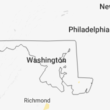


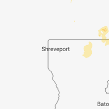


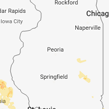


Cities Most Affected by Hail Storms of 6/2/2018
| Hail Size | Demographics of Zip Codes Affected | ||||||
|---|---|---|---|---|---|---|---|
| City | Count | Average | Largest | Pop Density | House Value | Income | Age |
| Dover, AR | 3 | 2.17 | 2.50 | 28 | $65k | $31.9k | 41.0 |
| Hector, AR | 2 | 2.88 | 3.00 | 10 | $58k | $33.8k | 39.1 |
| Licking, MO | 1 | 2.50 | 2.50 | 21 | $60k | $23.7k | 38.2 |
| Hot Springs Village, AR | 1 | 2.00 | 2.00 | 223 | $145k | $44.6k | 65.9 |
| Marble Falls, AR | 1 | 1.75 | 1.75 | 15 | $46k | $31.9k | 45.3 |
| Harrison, AR | 1 | 1.75 | 1.75 | 81 | $77k | $30.5k | 40.7 |
Hail and Wind Damage Spotted on 6/2/2018
Filter by Report Type:Hail ReportsWind Reports
States Impacted
Iowa, Missouri, Kansas, Georgia, Kentucky, Florida, Arkansas, South Carolina, Oklahoma, Alabama, North Carolina, Texas, MississippiIowa
| Local Time | Report Details |
|---|---|
| 7:05 AM CDT | 1 1/2 foot diameter tree down. 50 mph wind gusts. via social medi in webster county IA, 51.9 miles E of Storm Lake, IA |
| 8:19 AM CDT | Storm damage reported in cerro gordo county IA, 6.6 miles W of Mason City, IA |
| 8:19 AM CDT | Several reports of large branches down on many trees on the east side of town. report received via social medi in cerro gordo county IA, 0.9 miles N of Mason City, IA |
| 8:35 AM CDT | Storm damage reported in franklin county IA, 27.4 miles S of Mason City, IA |
| 8:50 AM CDT | Large tree damag in cerro gordo county IA, 1.7 miles NNE of Mason City, IA |
| 9:14 AM CDT | Separate reports of tree limbs on power lines... a street signal broken... and two trees down in charles city. time estimated from radar and reported wind gusts at char in floyd county IA, 27.4 miles E of Mason City, IA |
| 9:25 AM CDT | Power lines and tree limbs down in the vicinity of osag in mitchell county IA, 22.1 miles ENE of Mason City, IA |
| 9:25 AM CDT | Power lines and tree limbs down in the vicinity of new have in mitchell county IA, 30 miles ENE of Mason City, IA |
| 9:30 AM CDT | 2 foot diameter tree down... via social medi in butler county IA, 41.7 miles SSE of Mason City, IA |
| 9:35 AM CDT | Via kwwl tv. 6-8 inch diameter trees down. other things blowing down the stree in butler county IA, 44.6 miles SSE of Mason City, IA |
| 10:00 AM CDT | Tree blown down in cresc in howard county IA, 53.2 miles SW of La Crosse, WI |
Missouri
| Local Time | Report Details |
|---|---|
| 8:12 AM CDT | Public social media report of large tree limb snapped in holts summit. time estimated from rada in callaway county MO, 24.4 miles SSE of Columbia, MO |
| 4:30 PM CDT | Ping Pong Ball sized hail reported near Newburg, MO, 28.7 miles WNW of Salem, MO, social media report. time approx based on radar. |
| 4:55 PM CDT | Tennis Ball sized hail reported near Licking, MO, 17.9 miles WSW of Salem, MO, social media post. time estimated by radar. report was just east of licking along highway 32. |
| 5:33 PM CDT | Quarter sized hail reported near Salem, MO, 7.4 miles W of Salem, MO, social media post. pea to quarter sized hail. time estimated based on radar. |
| 8:18 PM CDT | Corrects previous tstm wnd dmg report from 1 nnw ste. genevieve. large tree limb down blocking roadwa in ste. genevieve county MO, 45.3 miles S of Saint Louis, MO |
| 8:35 PM CDT | Half Dollar sized hail reported near Couch, MO, 76.7 miles SSE of Salem, MO, reported along hwy 142. strong winds and hail slightly larger than quarters. |
| 9:18 PM CDT | Large tree limb down blocking roadwa in ste. genevieve county MO, 45.3 miles S of Saint Louis, MO |
Kansas
| Local Time | Report Details |
|---|---|
| 9:50 AM CDT | Number of small tree limbs down with the largest up to 6 inches in diamete in shawnee county KS, 39 miles E of Manhattan, KS |
Georgia
| Local Time | Report Details |
|---|---|
| 1:55 PM EDT | Report of a tree falling on a vehicle in the albany are in dougherty county GA, 78.7 miles W of Douglas, GA |
| 2:18 PM EDT | Metal shed destroyed and blown 75-100 yard in colquitt county GA, 58.2 miles NNE of Tallahassee, FL |
| 2:18 PM EDT | Reports of trees and power lines down within the city of moultri in colquitt county GA, 58.7 miles NNE of Tallahassee, FL |
| 2:42 PM EDT | Reports of trees down around leno in cook county GA, 39.8 miles WSW of Douglas, GA |
| 3:03 PM EDT | Report of trees down in the tow in jeff davis county GA, 18.5 miles NNE of Douglas, GA |
| 3:11 PM EDT | Trees and power lines down for 6-7 miles along ed ray rd near denton... g in jeff davis county GA, 18.5 miles NNE of Douglas, GA |
| 3:18 PM EDT | Reports of trees down in lowndes count in lowndes county GA, 43.2 miles SSW of Douglas, GA |
| 3:20 PM EDT | Tree down across highway 122 between lakeland and walkers crossing near banks lak in lanier county GA, 36.4 miles SSW of Douglas, GA |
| 3:24 PM EDT | Reports of numerous trees down throughout lanier count in lanier county GA, 34.9 miles SSW of Douglas, GA |
| 3:25 PM EDT | Tstm wind gusts blew portions of a roof off of a large barn and blew over two trees just north of mount verno in montgomery county GA, 52.5 miles NNE of Douglas, GA |
| 3:30 PM EDT | Overturned farm equipment along highway 135 south near the lowndes-lanier county borde in lanier county GA, 40.6 miles SSW of Douglas, GA |
| 3:30 PM EDT | Tree down on a residence on withers roa in clinch county GA, 45.3 miles S of Douglas, GA |
| 3:45 PM EDT | Report of power lines down on county farm road near baxley... g in appling county GA, 32.8 miles ENE of Douglas, GA |
| 3:48 PM EDT | Screven county 911 reported a tree down on forest road in sylvani in screven county GA, 53.7 miles SSE of Augusta, GA |
| 4:05 PM EDT | Screven county 911 reported a tree down on poor robin r in screven county GA, 48.6 miles NNW of Savannah, GA |
| 4:05 PM EDT | Chatham county ema reported a large gadot highway sign down on i-16 near i-516 interchang in chatham county GA, 2.4 miles WSW of Savannah, GA |
| 4:24 PM EDT | Screven county 911 reported two trees down on hwy 24 southwest of olive in screven county GA, 40 miles NW of Savannah, GA |
| 4:32 PM EDT | Tree down over road on hwy 187... approximately 15 miles south of homerville. time of event estimated with rada in clinch county GA, 46.6 miles S of Douglas, GA |
| 4:43 PM EDT | Trained spotter reported quarter size hail and gusty winds just west of guyto in effingham county GA, 26.7 miles NW of Savannah, GA |
| 4:46 PM EDT | Chatham ema reports a tree down on a vehicle on moss driv in chatham county GA, 9.1 miles ESE of Savannah, GA |
| 4:54 PM EDT | Fort pulaski nos tide gage gusted to 40 mph at 454 pm... peak gust 61 mph at 500 p in chatham county GA, 11.7 miles ESE of Savannah, GA |
| 5:00 PM EDT | Estimated winds of 60 mph just east of folkston off of dora lloyd roa in charlton county GA, 40 miles NNW of Jacksonville, FL |
| 5:00 PM EDT | Fort pulaski nos tide gage gusted to 61 mp in chatham county GA, 11.7 miles ESE of Savannah, GA |
| 6:05 PM EDT | Trees reported down in blakel in early county GA, 73.9 miles NNW of Tallahassee, FL |
| 6:06 PM EDT | Tree reported down just south of donaldsonvill in seminole county GA, 53.1 miles NW of Tallahassee, FL |
| 6:20 PM EDT | Tree down near hwy 129 and sandy run rd; just north of bonair in houston county GA, 85.5 miles NNW of Douglas, GA |
| 6:54 PM EDT | Tree reported down on quincy hwy and bettstown r in decatur county GA, 30.3 miles NW of Tallahassee, FL |
Kentucky
| Local Time | Report Details |
|---|---|
| 1:23 PM CDT | Two trees down and a piece of metal roofing peeled off an outbuildin in ohio county KY, 49.3 miles SE of Evansville, IN |
Florida
| Local Time | Report Details |
|---|---|
| 1:24 PM CDT | Reports of trees down in the greenwood are in jackson county FL, 60.2 miles WNW of Tallahassee, FL |
| 3:25 PM EDT | Several large limbs down and some snapped trees reported in the woodville area. one large limb damaged a ca in leon county FL, 8.5 miles SSE of Tallahassee, FL |
| 4:20 PM EDT | Trees and power lines down across madison count in madison county FL, 55 miles E of Tallahassee, FL |
| 4:28 PM EDT | Tree and power line reported down near hwy 27 and san pedr in taylor county FL, 47.7 miles ESE of Tallahassee, FL |
| 4:40 PM EDT | Trees and powerlines down. time based on rada in suwannee county FL, 74.9 miles E of Tallahassee, FL |
| 4:55 PM EDT | Trees and powerlines down near 136a and adams road. time based on rada in suwannee county FL, 73.8 miles W of Jacksonville, FL |
| 5:30 PM EDT | Baker county 911/dispatch reports a tree downed by thunderstorm wind gusts along u.s. highway 90 in the vicinity of sanderson. time of damage estimated by rada in baker county FL, 36.4 miles W of Jacksonville, FL |
| 5:30 PM EDT | Tree reported down near highway 90 between sanderson and glen st mary. time based on rada in baker county FL, 32.8 miles W of Jacksonville, FL |
| 5:35 PM EDT | Cable pole downed and damaged 2 vehicles. time based on rada in baker county FL, 28.6 miles W of Jacksonville, FL |
| 6:00 PM EDT | Bradford county 911/dispatch reports a large tree limb downed across county road 233 and also over orange street in the vicinity of starke. time of damage based on rada in bradford county FL, 37.4 miles SW of Jacksonville, FL |
| 6:20 PM EDT | Wires reported down near hood road and sunbeam road. time based on rada in duval county FL, 9.5 miles SSE of Jacksonville, FL |
| 6:25 PM EDT | Tree down across path between fleming plantation blvd and village square pkw in clay county FL, 17.6 miles S of Jacksonville, FL |
| 6:25 PM EDT | Action news reported a tree downed by strong wind gusts in the julington creek community. time of damage based on radar dat in st. johns county FL, 16.3 miles SSE of Jacksonville, FL |
| 5:36 PM CDT | Tree reported down on river and butler r in jackson county FL, 46.5 miles WNW of Tallahassee, FL |
Arkansas
| Local Time | Report Details |
|---|---|
| 1:53 PM CDT | Golf Ball sized hail reported near Marble Falls, AR, 77.1 miles S of Springfield, MO |
| 1:53 PM CDT | Golf Ball sized hail reported near Harrison, AR, 69.5 miles S of Springfield, MO |
| 2:30 PM CDT | Quarter sized hail reported near Mount Judea, AR, 85 miles ENE of Fort Smith, AR, reports of quarter size hail... also had pea and marble size hail mixed in. |
| 4:42 PM CDT | Tea Cup sized hail reported near Hector, AR, 61.5 miles NW of Little Rock, AR, three-inch diameter hail fell on buck mountain. |
| 4:45 PM CDT | Baseball sized hail reported near Hector, AR, 61.2 miles NW of Little Rock, AR, multiple reports of baseball size hail from the hector area. |
| 4:54 PM CDT | Hen Egg sized hail reported near Dover, AR, 61.5 miles NW of Little Rock, AR |
| 4:55 PM CDT | Hen Egg sized hail reported near Dover, AR, 61.5 miles NW of Little Rock, AR |
| 4:55 PM CDT | Ping Pong Ball sized hail reported near Dover, AR, 62 miles NW of Little Rock, AR |
| 4:55 PM CDT | Tennis Ball sized hail reported near Dover, AR, 61.5 miles NW of Little Rock, AR |
| 5:50 PM CDT | Powerlines and poles snapped... lines hanging just feet above the ground across highway 64 between atkins and pottsvill in pope county AR, 52.4 miles NW of Little Rock, AR |
| 7:15 PM CDT | Quarter sized hail reported near Hot Springs Village, AR, 41.7 miles W of Little Rock, AR, quarter sized hail has been falling for 10-15 minutes on the west side of hot springs village. |
| 7:15 PM CDT | Ping Pong Ball sized hail reported near Hot Springs Village, AR, 41.7 miles W of Little Rock, AR |
| 7:20 PM CDT | Hen Egg sized hail reported near Hot Springs Village, AR, 45.5 miles W of Little Rock, AR |
| 7:27 PM CDT | Half Dollar sized hail reported near Hot Springs Village, AR, 41.7 miles W of Little Rock, AR, haill fell near lake desoto. |
| 7:35 PM CDT | Several boat docks were turned over on bull shoals lak in marion county AR, 69 miles SE of Springfield, MO |
| 8:00 PM CDT | A tree was blown down across a power line on highway 14 in the southern part of marion count in marion county AR, 85.8 miles SSE of Springfield, MO |
| 9:20 PM CDT | Several trees down around imboden. some struck by lightning...most blown over with high wind in lawrence county AR, 96.4 miles NW of Memphis, TN |
| 9:35 PM CDT | Several trees down all around black rock. highway 63 and county road 219. highway 25 closed due to trees across road. some trees hit by lightnin in craighead county AR, 50.9 miles NNW of Memphis, TN |
| 9:35 PM CDT | Several trees down all around black rock. highway 63 and county road 219. highway 25 closed due to trees across road. some trees hit by lightnin in lawrence county AR, 89.2 miles NW of Memphis, TN |
| 9:45 PM CDT | Power lines down and trees down around paragoul in greene county AR, 67.9 miles NNW of Memphis, TN |
| 9:50 PM CDT | Porch removed out front of home in tow in lawrence county AR, 77.3 miles NW of Memphis, TN |
| 9:52 PM CDT | A storm chaser reported damage to some outbuilding in jackson county AR, 76.5 miles NW of Memphis, TN |
| 10:00 PM CDT | Trees down and power lines down around walnut ridg in lawrence county AR, 81.6 miles NW of Memphis, TN |
| 10:05 PM CDT | Trees and power lines were blown dow in jackson county AR, 76.3 miles WNW of Memphis, TN |
| 10:25 PM CDT | Trees and pwer lines down just west of waldenburg in poinsett county AR, 59.2 miles WNW of Memphis, TN |
| 10:25 PM CDT | Trees and power lines were blown dow in jackson county AR, 66.3 miles WNW of Memphis, TN |
| 10:29 PM CDT | Storm damage reported in jackson county AR, 63.4 miles WNW of Memphis, TN |
| 10:50 PM CDT | Wind damage to power sub staio in poinsett county AR, 57.1 miles WNW of Memphis, TN |
| 11:15 PM CDT | Trees down at fitzgerald crossing south of town. possible tornad in cross county AR, 42 miles W of Memphis, TN |
| 11:20 PM CDT | Airport destroyed in st. francis county AR, 43.1 miles W of Memphis, TN |
| 11:25 PM CDT | House collapsed with preliminary reports of people trapped inside. likely high winds took roof of in st. francis county AR, 43.1 miles WSW of Memphis, TN |
| 11:30 PM CDT | Damage to waffle house and two overturned semi-trailers off i-40 and highway 1 exi in st. francis county AR, 43.1 miles WSW of Memphis, TN |
| 12:05 AM CDT | Numerous trees and power lines down across town with a widespread power outage. additional trees down on houses across the city and one trailer north of town.appears th in st. francis county AR, 43.1 miles WSW of Memphis, TN |
| 4:00 AM CDT | Quarter sized hail reported near Hamburg, AR, 31.8 miles NNE of Bastrop, LA, quarter sized hail reported in downtown hamburg. |
South Carolina
| Local Time | Report Details |
|---|---|
| 3:12 PM EDT | Dispatch reported a tree blown down on carolina place. at least one other tree down in the are in york county SC, 14.6 miles SSW of Charlotte, NC |
| 3:15 PM EDT | Large limbs down and dime size hai in york county SC, 15.2 miles SSW of Charlotte, NC |
| 3:20 PM EDT | A couple trees and powerlines dow in pickens county SC, 14.7 miles WNW of Greenville, SC |
| 4:36 PM EDT | A few trees blown down on powerline in oconee county SC, 31.1 miles WSW of Greenville, SC |
| 5:02 PM EDT | Jasper county 911 reported a tree down on i-95 southbound near mm1 in jasper county SC, 24.5 miles N of Savannah, GA |
| 5:27 PM EDT | Schp reports a tree down on bees creek rd near scarlett ibis d in jasper county SC, 26.3 miles NNE of Savannah, GA |
| 5:45 PM EDT | Colleton county 911 reported at least two trees down... power lines down... and hail of unknown size on sidneys r in colleton county SC, 31.4 miles WSW of Charleston, SC |
| 6:09 PM EDT | Multiple trees down on property on the 2300 block of mcdanieltown road. time estimated using radar dat in colleton county SC, 28.7 miles SW of Charleston, SC |
| 6:22 PM EDT | Trees and powerpole down near the intersection of north jefferies and ivanhoe road. time estimated from radar dat in colleton county SC, 43 miles WSW of Charleston, SC |
| 6:40 PM EDT | Charleston county 911 reported a tree snapped off and brought down power lines on bexley st in north charlesto in charleston county SC, 22.6 miles S of Charleston, SC |
| 6:41 PM EDT | Charleston county 911 reported traffic lights blown down on n rhett ave near the mark clark expresswa in charleston county SC, 20.5 miles S of Charleston, SC |
| 6:41 PM EDT | One tree down on brockington ave and two power lines down on ashley river rd. traffic being reroute in charleston county SC, 26.6 miles S of Charleston, SC |
| 8:06 PM EDT | Tree down on gum swamp road. reported by aiken county dispatc in aiken county SC, 7.3 miles SSE of Augusta, GA |
Oklahoma
| Local Time | Report Details |
|---|---|
| 2:46 PM CDT | Quarter sized hail reported near Hodgen, OK, 40 miles SSW of Fort Smith, AR |
Alabama
| Local Time | Report Details |
|---|---|
| 3:46 PM CDT | Tree down on hwy 105 near skippervill in dale county AL, 72.3 miles S of Auburn, AL |
| 4:18 PM CDT | 3 trees reported down in the newville are in henry county AL, 82.2 miles S of Auburn, AL |
| 7:27 PM CDT | Trees down near the intersection of hwy 84 and hwy 31 east of evergreen... a in conecuh county AL, 46.3 miles SSE of Camden, AL |
| 7:57 PM CDT | Trees down southwest of evergreen on old sparta roa in conecuh county AL, 46.7 miles SSE of Camden, AL |
North Carolina
| Local Time | Report Details |
|---|---|
| 5:50 PM EDT | Tree down on polly watson rd in fremon in wayne county NC, 36.5 miles ESE of Raleigh, NC |
| 6:30 PM EDT | Spotter reports trees down blocking driveway on goodson roa in rowan county NC, 37.7 miles NNE of Charlotte, NC |
| 6:32 PM EDT | Tree down on wheaton c in rowan county NC, 34.5 miles NNE of Charlotte, NC |
| 6:35 PM EDT | Quarter sized hail reported near Salisbury, NC, 35.1 miles NNE of Charlotte, NC, quarter size hail being reported on sherrills ford road. a tree down on hwy 70 in salisbury. |
Texas
| Local Time | Report Details |
|---|---|
| 7:20 PM CDT | Ping Pong Ball sized hail reported near Ozona, TX, 90 miles SE of Odessa, TX |
| 9:15 PM CDT | Quarter sized hail reported near Ranger, TX, 62 miles E of Abilene, TX, quarter size hail reported in ranger. |
| 9:30 PM CDT | Quarter sized hail reported near Eastland, TX, 57.8 miles E of Abilene, TX, nickel and quarter size hail reported near lake leon |
Mississippi
| Local Time | Report Details |
|---|---|
| 1:29 AM CDT | Quarter sized hail reported near Shelby, MS, 92.4 miles SSW of Memphis, TN, nickel to quarter size hail in shelby. |
| 1:50 AM CDT | Tree downed on a house in rosedal in bolivar county MS, 90.4 miles NE of Bastrop, LA |
| 2:19 AM CDT | Tree down across a power line near sha in bolivar county MS, 87.2 miles NE of Bastrop, LA |
Connect with Interactive Hail Maps