

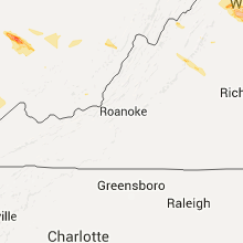
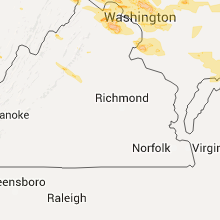
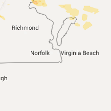
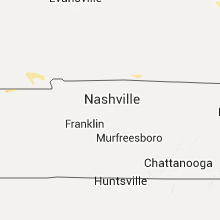
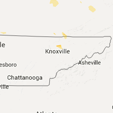
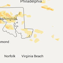
Hail Map for Tuesday, June 21, 2016

Number of Impacted Households on 6/21/2016
0
Impacted by 1" or Larger Hail
0
Impacted by 1.75" or Larger Hail
0
Impacted by 2.5" or Larger Hail
Square Miles of Populated Area Impacted on 6/21/2016
0
Impacted by 1" or Larger Hail
0
Impacted by 1.75" or Larger Hail
0
Impacted by 2.5" or Larger Hail


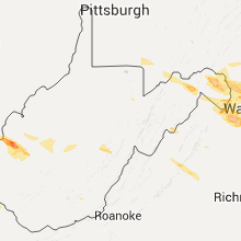

Cities Most Affected by Hail Storms of 6/21/2016
| Hail Size | Demographics of Zip Codes Affected | ||||||
|---|---|---|---|---|---|---|---|
| City | Count | Average | Largest | Pop Density | House Value | Income | Age |
| New England, ND | 3 | 2.42 | 2.75 | 1 | $37k | $29.1k | 46.8 |
| Watford City, ND | 3 | 2.08 | 2.75 | 2 | $51k | $30.1k | 42.0 |
| Fairview, MT | 3 | 1.75 | 1.75 | 3 | $41k | $32.1k | 41.3 |
| Hurricane, WV | 2 | 2.50 | 3.25 | 242 | $120k | $46.4k | 39.9 |
| Mott, ND | 2 | 1.75 | 1.75 | 2 | $29k | $28.8k | 51.1 |
| Hettinger, ND | 1 | 3.00 | 3.00 | 2 | $42k | $29.8k | 49.3 |
| Scott Depot, WV | 1 | 2.50 | 2.50 | 388 | $121k | $47.1k | 41.7 |
| New Town, ND | 1 | 2.50 | 2.50 | 2 | $48k | $28.6k | 31.7 |
| Regent, ND | 1 | 2.50 | 2.50 | 1 | $20k | $30.5k | 49.3 |
| Milton, WV | 1 | 1.75 | 1.75 | 131 | $86k | $32.2k | 42.6 |
| Garrison, ND | 1 | 1.75 | 1.75 | 4 | $51k | $31.3k | 49.8 |
| Brandywine, MD | 1 | 1.75 | 1.75 | 178 | $161k | $62.8k | 40.8 |
| Betterton, MD | 1 | 1.75 | 1.75 | 143 | $90k | $36.1k | 47.4 |
| Halliday, ND | 1 | 1.75 | 1.75 | 1 | $21k | $21.7k | 40.8 |
| Chantilly, VA | 1 | 1.75 | 1.75 | 1391 | $216k | $89.9k | 36.5 |
| Frederick, MD | 1 | 1.75 | 1.75 | 1009 | $143k | $58.0k | 33.3 |
| La Plata, MD | 1 | 1.75 | 1.75 | 219 | $181k | $68.3k | 42.2 |
| Waldorf, MD | 1 | 1.75 | 1.75 | 1735 | $170k | $71.8k | 34.5 |
| Nashua, MT | 1 | 1.75 | 1.75 | 1 | $39k | $26.9k | 51.6 |
Hail and Wind Damage Spotted on 6/21/2016
Filter by Report Type:Hail ReportsWind Reports
States Impacted
Pennsylvania, Maryland, Virginia, Kentucky, West Virginia, New Jersey, Delaware, Montana, Tennessee, North Dakota, South Dakota, Iowa, IllinoisPennsylvania
| Local Time | Report Details |
|---|---|
| 8:02 AM EDT | Quarter sized hail reported near East Berlin, PA, 49 miles NNW of Baltimore, MD, quarter size hail in east berlin |
| 8:09 AM EDT | Roof off of building on north main street in york county PA, 42.8 miles NNW of Baltimore, MD |
| 8:12 AM EDT | Trees and wires down on pine grove road in york county PA, 43.8 miles N of Baltimore, MD |
| 7:25 PM EDT | Quarter sized hail reported near Jamison, PA, 65.5 miles WSW of Brooklyn, NY |
Maryland
| Local Time | Report Details |
|---|---|
| 1:00 PM EDT | Trees and wires down blocking barnesville road in montgomery county MD, 34.3 miles W of Baltimore, MD |
| 1:05 PM EDT | Two trees down on shookstown road on the western side of frederic in frederick county MD, 46 miles WNW of Baltimore, MD |
| 1:37 PM EDT | Multiple large trees twisted and broken in half in howard county MD, 20.9 miles W of Baltimore, MD |
| 1:45 PM EDT | Multiple large trees down. one tree onto a fenc in howard county MD, 21.6 miles W of Baltimore, MD |
| 1:45 PM EDT | Dozens of tree limbs 5 to 6 inches blocking roads in howard county MD, 14.8 miles WSW of Baltimore, MD |
| 1:53 PM EDT | Tree down along greenfield roa in frederick county MD, 45.1 miles W of Baltimore, MD |
| 2:05 PM EDT | Six trees down in the median southbound 295 near hanove in anne arundel county MD, 8.8 miles SW of Baltimore, MD |
| 2:07 PM EDT | Golf Ball sized hail reported near Betterton, MD, 29.4 miles E of Baltimore, MD |
| 2:07 PM EDT | Storm damage reported in anne arundel county MD, 8.3 miles SSW of Baltimore, MD |
| 2:10 PM EDT | Multiple trees and wires down. time estimated from radar in kent county MD, 29.4 miles E of Baltimore, MD |
| 2:17 PM EDT | Quarter sized hail reported near Severn, MD, 11.2 miles SSW of Baltimore, MD |
| 2:25 PM EDT | Quarter sized hail reported near Gaithersburg, MD, 31.7 miles WSW of Baltimore, MD, quarter size hail |
| 2:30 PM EDT | Multiple trees down across the roadway. time estimated from radar in kent county MD, 30.1 miles E of Baltimore, MD |
| 2:40 PM EDT | Multiple trees down near howard county fairgrounds in howard county MD, 18.8 miles W of Baltimore, MD |
| 2:40 PM EDT | Multiple trees down near the fairgrounds in howard county MD, 10.2 miles WSW of Baltimore, MD |
| 2:41 PM EDT | Storm damage reported in anz532 county MD, 25.8 miles SSE of Baltimore, MD |
| 3:43 PM EDT | Golf Ball sized hail reported near Waldorf, MD, 50.2 miles SSW of Baltimore, MD |
| 3:45 PM EDT | Golf Ball sized hail reported near La Plata, MD, 58.3 miles SSW of Baltimore, MD |
| 3:45 PM EDT | Trees down in caroline county MD, 44.1 miles SE of Baltimore, MD |
| 3:48 PM EDT | Ping Pong Ball sized hail reported near Waldorf, MD, 51 miles SSW of Baltimore, MD |
| 3:50 PM EDT | Half Dollar sized hail reported near Waldorf, MD, 49.7 miles SSW of Baltimore, MD |
| 3:53 PM EDT | Quarter sized hail reported near Waldorf, MD, 47.2 miles SSW of Baltimore, MD |
| 3:58 PM EDT | Golf Ball sized hail reported near Brandywine, MD, 46 miles SSW of Baltimore, MD |
| 5:05 PM EDT | Power lines down due to win in wicomico county MD, 33.8 miles W of Ocean City, MD |
| 5:20 PM EDT | Quarter sized hail reported near Clarksburg, MD, 38.1 miles W of Baltimore, MD |
| 5:25 PM EDT | Tree down due to wind in somerset county MD, 32.5 miles WSW of Ocean City, MD |
| 5:26 PM EDT | Very large tree down on princess anne road in somerset county MD, 34.6 miles WSW of Ocean City, MD |
| 5:32 PM EDT | Quarter sized hail reported near Knoxville, MD, 56.4 miles W of Baltimore, MD |
| 5:32 PM EDT | Power lines down due to winds in worcester county MD, 19.8 miles WSW of Ocean City, MD |
| 5:38 PM EDT | Quarter sized hail reported near Brunswick, MD, 54.2 miles W of Baltimore, MD |
| 6:10 PM EDT | 2 power lines downed along md-12 near intersection with worcester hw in worcester county MD, 20.1 miles SW of Ocean City, MD |
| 7:40 PM EDT | Golf Ball sized hail reported near Frederick, MD, 46.4 miles W of Baltimore, MD |
| 7:45 PM EDT | Quarter sized hail reported near Frederick, MD, 45.4 miles W of Baltimore, MD |
Virginia
| Local Time | Report Details |
|---|---|
| 1:29 PM EDT | Tree down along stone springs blv in loudoun county VA, 55.2 miles WSW of Baltimore, MD |
| 2:20 PM EDT | Couple of trees down near luray caverns in page county VA, 76.4 miles ESE of Elkins, WV |
| 3:09 PM EDT | Trees down at watson road and manbar lane in fauquier county VA, 72.2 miles WSW of Baltimore, MD |
| 3:15 PM EDT | Quarter sized hail reported near Ashburn, VA, 53.4 miles WSW of Baltimore, MD |
| 3:27 PM EDT | Braddock road at tre towers court closed for a downed tree in fairfax county VA, 54.7 miles WSW of Baltimore, MD |
| 3:30 PM EDT | Golf Ball sized hail reported near Chantilly, VA, 54.8 miles WSW of Baltimore, MD |
| 4:50 PM EDT | Multiple trees down on ridgeside road in loudoun county VA, 67.6 miles WSW of Baltimore, MD |
| 5:15 PM EDT | Several trees down near ewing... v in lee county VA, 53.7 miles NNE of Knoxville, TN |
| 6:18 PM EDT | 911 call center reports multiple trees down along kents ridge road near the community of richland in tazewell county VA, 40.7 miles NE of Bristol, TN |
| 6:35 PM EDT | Trees down near the swords creek are in russell county VA, 35.2 miles NNE of Bristol, TN |
| 6:57 PM EDT | Half Dollar sized hail reported near Reston, VA, 45 miles WSW of Baltimore, MD |
Kentucky
| Local Time | Report Details |
|---|---|
| 1:47 PM EDT | Large limbs down along new columbus road. time estimated from rada in owen county KY, 44.4 miles S of Cincinnati, OH |
| 1:47 PM EDT | House damaged by straight line winds along mountain island road. time estimated from rada in owen county KY, 43.9 miles S of Cincinnati, OH |
| 1:51 PM EDT | Multiple power poles down along sr-8 near garrison. time estimated from rada in lewis county KY, 75.9 miles NE of Irvine, KY |
| 2:30 PM EDT | Several large trees down along winchester road in fayette and clark counties. in clark county KY, 28.6 miles NW of Irvine, KY |
| 3:05 PM EDT | Roof damage to building in louisa...metal roof partially torn from rafters with pictures. radar estimated tim in lawrence county KY, 54.8 miles WSW of Charleston, WV |
| 3:30 PM EDT | Trees down on tipton ridge roa in estill county KY, 5.2 miles E of Irvine, KY |
| 3:30 PM EDT | Trees down on sand hill roa in estill county KY, 2.6 miles WNW of Irvine, KY |
| 3:30 PM EDT | Trees down on barnes mountain roa in estill county KY, 4.5 miles SE of Irvine, KY |
| 3:15 PM CDT | 2 trees down about 1000 feet apart... 6-8 inches in diameter. spotter near this location reported winds to 40 mph. time approximate in calloway county KY, 45.3 miles NNE of Mc Kenzie, TN |
| 4:41 PM EDT | One tree down on bird branch road. also had dime-sized hai in bell county KY, 56.7 miles NNE of Knoxville, TN |
West Virginia
| Local Time | Report Details |
|---|---|
| 1:50 PM EDT | Golf Ball sized hail reported near Milton, WV, 26.2 miles WNW of Charleston, WV, time estimated from radar |
| 1:53 PM EDT | Quarter sized hail reported near Springfield, WV, 75.1 miles ENE of Elkins, WV |
| 1:55 PM EDT | Quarter sized hail reported near Fraziers Bottom, WV, 24.3 miles NW of Charleston, WV |
| 2:04 PM EDT | Tea Cup sized hail reported near Hurricane, WV, 22.5 miles WNW of Charleston, WV |
| 2:15 PM EDT | Golf Ball sized hail reported near Hurricane, WV, 21.6 miles WNW of Charleston, WV, sheriff deputy reported golf ball hail along i-64 between hurricane and teays valley. between mile markers 34 through 39 |
| 2:20 PM EDT | Tennis Ball sized hail reported near Scott Depot, WV, 17.2 miles WNW of Charleston, WV |
| 2:26 PM EDT | Trees down in nitro along dupont avenue in kanawha county WV, 5.2 miles WSW of Charleston, WV |
| 2:26 PM EDT | Trees down in nitro along dupont avenue in kanawha county WV, 11.6 miles W of Charleston, WV |
| 2:26 PM EDT | Trees down in nitro along dupont avenue in kanawha county WV, 11.4 miles WNW of Charleston, WV |
| 2:27 PM EDT | Quarter sized hail reported near Cowen, WV, 52.3 miles SW of Elkins, WV, via facebook |
| 2:36 PM EDT | Tree and power lines down along price street in charleston in kanawha county WV, 0.5 miles E of Charleston, WV |
| 2:36 PM EDT | Tree and power lines down along price street in charleston in kanawha county WV, 2.8 miles SSW of Charleston, WV |
| 2:36 PM EDT | Tree and power lines down along price street in charleston in kanawha county WV, 5.2 miles WSW of Charleston, WV |
| 2:40 PM EDT | Trees and power lines down along rays branch road in davis creek. radar estimated tim in kanawha county WV, 5.2 miles WSW of Charleston, WV |
| 3:01 PM EDT | Received a slew of facebook pictures showing extensive tree damage. so much that you cannot make out where the road i in nicholas county WV, 60.2 miles SW of Elkins, WV |
| 3:01 PM EDT | Received a slew of facebook pictures showing extensive tree damage. so much that you cannot make out where the road is. along country club road on forest road 9 in nicholas county WV, 58.1 miles SW of Elkins, WV |
| 3:05 PM EDT | Multiple trees were blown down along the access road leading to summit lake campgroun in greenbrier county WV, 57.1 miles SW of Elkins, WV |
| 3:07 PM EDT | Forest service reports extensive tree damage along multiple ridges near summit lake. estimated 50-100 or more trees downed or snapped in half. time is based on radar es in greenbrier county WV, 56.6 miles SW of Elkins, WV |
| 3:15 PM EDT | Emergency manager reports two trees down along route 39 in the northern most greenbrier county in west virgini in greenbrier county WV, 58.1 miles SSW of Elkins, WV |
| 3:26 PM EDT | Trees down in nitro along dupont avenue in kanawha county WV, 5.2 miles WSW of Charleston, WV |
| 3:36 PM EDT | Tree and power lines down along price street in charleston in kanawha county WV, 5.2 miles WSW of Charleston, WV |
| 4:05 PM EDT | Blocked roads... power outages from trees down. particularly on county rt 3/5 in mingo county WV, 44 miles SW of Charleston, WV |
| 4:15 PM EDT | Realtor reported a tree down on timberline road in tucker county WV, 23.9 miles ENE of Elkins, WV |
| 4:28 PM EDT | Trees and power lines down along rays branch road in davis creek in kanawha county WV, 5.2 miles WSW of Charleston, WV |
| 4:58 PM EDT | Emergency manager reports scattered trees down across the county from thunderstorm winds. mainly located near hinton and points north and eas in summers county WV, 58.4 miles WNW of Roanoke, VA |
| 5:24 PM EDT | 911 call center reports tree down along willow wood road. time is radar estimate in summers county WV, 53.7 miles WNW of Roanoke, VA |
| 8:33 PM EDT | Quarter sized hail reported near Martinsburg, WV, 76.5 miles W of Baltimore, MD |
| 8:41 PM EDT | Quarter sized hail reported near Martinsburg, WV, 72.2 miles W of Baltimore, MD |
New Jersey
| Local Time | Report Details |
|---|---|
| 3:02 PM EDT | Quarter sized hail reported near Barnegat, NJ, 65.8 miles SSW of Brooklyn, NY, image sent to nws. time 3-305pm. |
| 3:10 PM EDT | Quarter sized hail reported near Waretown, NJ, 63.2 miles S of Brooklyn, NY |
| 3:18 PM EDT | Half Dollar sized hail reported near Barnegat, NJ, 65.2 miles SSW of Brooklyn, NY, observed on garden state parkway between exit 67a and 67b |
| 3:35 PM EDT | Storm damage reported in cape may county NJ, 44.3 miles N of Ocean City, MD |
| 3:35 PM EDT | Storm damage reported in cape may county NJ, 42.9 miles NNE of Ocean City, MD |
| 3:36 PM EDT | Storm damage reported in cape may county NJ, 44.3 miles N of Ocean City, MD |
| 3:40 PM EDT | Multiple trees down in green creek and in shady lane in cape may county NJ, 50.3 miles NNE of Ocean City, MD |
| 3:40 PM EDT | House with windows blown out. and large branches down in cape may county NJ, 47.9 miles N of Ocean City, MD |
| 3:45 PM EDT | Storm damage reported in cape may county NJ, 42.2 miles N of Ocean City, MD |
| 3:45 PM EDT | Large branches down in cape may county NJ, 50.3 miles NNE of Ocean City, MD |
| 3:45 PM EDT | Two power poles snapped in half on the east delaware parkway...and roof damage to a house near pacific ave in cape may county NJ, 47.9 miles N of Ocean City, MD |
| 3:50 PM EDT | Tree fell on a house in whitesboro in cape may county NJ, 50.1 miles NNE of Ocean City, MD |
| 3:50 PM EDT | Storm damage reported in cape may county NJ, 44.5 miles NNE of Ocean City, MD |
| 4:07 PM EDT | Power outage and numerous trees down...power out is middle twp as well. in cape may county NJ, 45.6 miles NNE of Ocean City, MD |
| 4:08 PM EDT | Southbound route 9 at route 47 tree down impacting traffic in cape may county NJ, 48.5 miles NNE of Ocean City, MD |
| 4:54 PM EDT | Quarter sized hail reported near Forked River, NJ, 59.1 miles SSW of Brooklyn, NY |
Delaware
| Local Time | Report Details |
|---|---|
| 3:30 PM EDT | Storm damage reported in new castle county DE, 68.6 miles ENE of Baltimore, MD |
| 3:30 PM EDT | Corrected in anz431 county DE, 45.2 miles N of Ocean City, MD |
| 4:00 PM EDT | Trees and power lines down in sussex county DE, 29.6 miles NW of Ocean City, MD |
Montana
| Local Time | Report Details |
|---|---|
| 2:56 PM MDT | Wind gust from thunderstorm outflo in fergus county MT, 70.3 miles E of Great Falls, MT |
| 3:15 PM MDT | Quarter sized hail reported near Chinook, MT, 20.4 miles E of Havre, MT, quarter sized hail reported in chinook. |
| 3:31 PM MDT | Quarter sized hail reported near Harlem, MT, 42.1 miles E of Havre, MT, nickle sized hail with a few to the size of a quarter. |
| 4:00 PM MDT | Quarter sized hail reported near Dodson, MT, 67.1 miles E of Havre, MT |
| 4:16 PM MDT | 67 mph wind gust from thunderstorm outflo in hill county MT, 40.3 miles W of Havre, MT |
| 5:20 PM MDT | King coulee raws site / kigm8 in valley county MT, 34.3 miles SSW of Glasgow, MT |
| 6:00 PM MDT | Golf Ball sized hail reported near Nashua, MT, 17.1 miles NE of Glasgow, MT |
| 6:58 PM MDT | Quarter sized hail reported near Wolf Point, MT, 51.2 miles E of Glasgow, MT, pea sized up to quarter sized hail. |
| 6:58 PM MDT | Estimated 50 to 60 mph wind gust in roosevelt county MT, 51.2 miles E of Glasgow, MT |
| 7:20 PM MDT | Poplar raws in roosevelt county MT, 67 miles W of Williston, ND |
| 7:34 PM MDT | Quarter sized hail reported near Poplar, MT, 62.6 miles WSW of Williston, ND |
| 7:45 PM MDT | Large portions of trees broken off. possible damage to structures. occurrence was along highway 201 south of brockton. time estimated from rada in richland county MT, 63.4 miles WSW of Williston, ND |
| 7:55 PM MDT | Ping Pong Ball sized hail reported near Sidney, MT, 40.9 miles WSW of Williston, ND |
| 8:01 PM MDT | Golf Ball sized hail reported near Fairview, MT, 36.3 miles WSW of Williston, ND, social media report. |
| 8:08 PM MDT | Sioux pass dot ob site on mt 16 in richland county MT, 36.4 miles WSW of Williston, ND |
| 8:10 PM MDT | Golf Ball sized hail reported near Fairview, MT, 33.7 miles WSW of Williston, ND |
| 8:19 PM MDT | Golf Ball sized hail reported near Fairview, MT, 24.1 miles SW of Williston, ND, golf ball sized hail occurred for 11 minutes from 819 pm mdt until 830 pm mdt. |
Tennessee
| Local Time | Report Details |
|---|---|
| 7:20 PM EDT | Several trees and power lines down near clairfield... t in claiborne county TN, 40.7 miles N of Knoxville, TN |
| 7:45 PM EDT | Quarter sized hail reported near Maynardville, TN, 20.9 miles NNE of Knoxville, TN |
| 7:45 PM EDT | Several trees down near maynardville... t in union county TN, 20.9 miles NNE of Knoxville, TN |
| 8:00 PM EDT | Several trees down all along highway 3 in union county TN, 20.9 miles NNE of Knoxville, TN |
North Dakota
| Local Time | Report Details |
|---|---|
| 5:41 PM MDT | Quarter sized hail reported near Medora, ND, 86.3 miles S of Williston, ND, . the duration of the hail event was 6 minutes. |
| 5:41 PM MDT | Quarter sized hail reported near Medora, ND, 86.3 miles S of Williston, ND, hail was dime size at 639 pm and quarter size at 641 pm...and ongoing. |
| 6:25 PM MDT | Ping Pong Ball sized hail reported near Belfield, ND, 103.9 miles S of Williston, ND, walnut sized hail fell for 10 minutes. |
| 7:15 PM MDT | Tea Cup sized hail reported near Hettinger, ND, 105.3 miles WSW of Bismarck, ND |
| 7:15 PM MDT | Tennis Ball sized hail reported near New England, ND, 103 miles W of Bismarck, ND, hail continues at the time of this lsr issuance. |
| 7:18 PM MDT | Baseball sized hail reported near New England, ND, 101.1 miles W of Bismarck, ND, a few baseball size hail pieces |
| 8:18 PM CDT | Quarter sized hail reported near Epping, ND, 18.7 miles ESE of Williston, ND, 25 mph winds... temperature fell from 85 to 75 in 20 minutes. |
| 7:30 PM MDT | Golf Ball sized hail reported near Halliday, ND, 79.2 miles WNW of Bismarck, ND, mostly quarters... few golf balls |
| 7:38 PM MDT | Ping Pong Ball sized hail reported near Regent, ND, 88.9 miles WSW of Bismarck, ND, still ongoing |
| 8:40 PM CDT | Baseball sized hail reported near Watford City, ND, 23.3 miles SE of Williston, ND, still ongoing |
| 7:40 PM MDT | Hen Egg sized hail reported near New England, ND, 93.4 miles WSW of Bismarck, ND, still ongoing |
| 7:41 PM MDT | Tennis Ball sized hail reported near Regent, ND, 88.9 miles WSW of Bismarck, ND, still ongoing |
| 7:48 PM MDT | Golf Ball sized hail reported near Mott, ND, 88.7 miles WSW of Bismarck, ND |
| 7:55 PM MDT | Golf Ball sized hail reported near Mott, ND, 79.5 miles WSW of Bismarck, ND, also had 60 mph winds with storm. . the duration of the hail event was 12 minutes. |
| 9:00 PM CDT | Ping Pong Ball sized hail reported near Keene, ND, 35 miles ESE of Williston, ND |
| 9:06 PM CDT | Storm damage reported in mckenzie county ND, 35 miles ESE of Williston, ND |
| 9:33 PM CDT | Tennis Ball sized hail reported near New Town, ND, 52.8 miles ESE of Williston, ND, hail up to the size of tennis balls near the intersection of 31st avenue nw and 92nd avenue nw south of new town. |
| 10:08 PM CDT | Golf Ball sized hail reported near Watford City, ND, 28.7 miles SSE of Williston, ND, golf ball sized hail at approximately 1008 pm cdt. quarter sized hail was falling at 1012 pm cdt. |
| 10:12 PM CDT | Golf Ball sized hail reported near Watford City, ND, 24.9 miles SE of Williston, ND |
| 10:13 PM CDT | Ping Pong Ball sized hail reported near Watford City, ND, 28.7 miles SSE of Williston, ND |
| 10:13 PM CDT | Storm damage reported in mckenzie county ND, 28.7 miles SSE of Williston, ND |
| 9:22 PM MDT | Quarter sized hail reported near Stanton, ND, 45.4 miles NW of Bismarck, ND |
| 11:00 PM CDT | Golf Ball sized hail reported near Garrison, ND, 40.6 miles S of Minot, ND |
| 12:40 AM CDT | Storm damage reported in burleigh county ND, 6.5 miles N of Bismarck, ND |
| 1:20 AM CDT | Mesonet station 2 e moffit /ts633/ time estimated from rada in burleigh county ND, 27 miles ESE of Bismarck, ND |
| 1:50 AM CDT | Power lines down south of napoleon on highway 3. also a 70 foot structure toppled over. in logan county ND, 57.1 miles ESE of Bismarck, ND |
| 1:58 AM CDT | Storm damage reported in mcintosh county ND, 69.3 miles ESE of Bismarck, ND |
| 2:57 AM CDT | Frederick rwis. 7 miles north of frederic in brown county SD, 33.3 miles N of Aberdeen, SD |
| 3:02 AM CDT | Frederick rwi in dickey county ND, 33.3 miles N of Aberdeen, SD |
South Dakota
| Local Time | Report Details |
|---|---|
| 8:50 PM MDT | Quarter sized hail reported near Belvidere, SD, 55.3 miles WSW of Pierre, SD |
| 8:55 PM MDT | Quarter sized hail reported near Belvidere, SD, 50.4 miles SW of Pierre, SD |
| 11:17 PM CDT | Quarter sized hail reported near Pollock, SD, 66.8 miles SSE of Bismarck, ND, pea to quarter size hail in pollock. street flooding in town as well. |
| 3:13 AM CDT | Estimated 50 to 60 mph winds in brown county SD, 24.7 miles NNE of Aberdeen, SD |
Iowa
| Local Time | Report Details |
|---|---|
| 1:28 AM CDT | Storm damage reported in clay county IA, 36.1 miles N of Storm Lake, IA |
| 2:00 AM CDT | Large tree limb down. report received via social medi in clay county IA, 23 miles NNE of Storm Lake, IA |
| 2:12 AM CDT | Measured by algona awo in kossuth county IA, 54.3 miles W of Mason City, IA |
| 2:55 AM CDT | Storm damage reported in muscatine county IA, 49.9 miles SSE of Cedar Rapids, IA |
| 3:00 AM CDT | Tree branch downed onto law enforcement vehicl in webster county IA, 53 miles E of Storm Lake, IA |
Illinois
| Local Time | Report Details |
|---|---|
| 3:27 AM CDT | Mercer county sheriffs office reported a large tree limb down along route 1 in mercer county IL, 67.3 miles NE of Kahoka, MO |
| 4:33 AM CDT | Tree down on rt. 95 in fulton county IL, 40 miles WSW of Peoria, IL |
| 4:47 AM CDT | Tree limbs and power lines down in mason county IL, 36.8 miles SW of Peoria, IL |
Connect with Interactive Hail Maps