

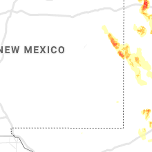
Hail Map for Monday, June 22, 2020

Number of Impacted Households on 6/22/2020
0
Impacted by 1" or Larger Hail
0
Impacted by 1.75" or Larger Hail
0
Impacted by 2.5" or Larger Hail
Square Miles of Populated Area Impacted on 6/22/2020
0
Impacted by 1" or Larger Hail
0
Impacted by 1.75" or Larger Hail
0
Impacted by 2.5" or Larger Hail


Cities Most Affected by Hail Storms of 6/22/2020
| Hail Size | Demographics of Zip Codes Affected | ||||||
|---|---|---|---|---|---|---|---|
| City | Count | Average | Largest | Pop Density | House Value | Income | Age |
| Vega, TX | 2 | 2.88 | 3.25 | 0 | $53k | $30.7k | 38.8 |
| Portales, NM | 2 | 2.38 | 2.50 | 28 | $55k | $26.6k | 29.0 |
| Perryton, TX | 2 | 2.25 | 2.50 | 13 | $49k | $38.0k | 31.5 |
| Stratford, TX | 1 | 2.50 | 2.50 | 0 | $47k | $32.3k | 36.3 |
| Waka, TX | 1 | 2.25 | 2.25 | 0 | $19k | $38.5k | 50.5 |
| Cortland, NE | 1 | 2.00 | 2.00 | 11 | $94k | $43.1k | 40.2 |
| Wildorado, TX | 1 | 2.00 | 2.00 | 1 | $65k | $38.8k | 40.1 |
| Ozona, TX | 1 | 2.00 | 2.00 | 0 | $52k | $29.9k | 39.5 |
| Shattuck, OK | 1 | 1.75 | 1.75 | 4 | $37k | $27.6k | 43.2 |
| Arnett, OK | 1 | 1.75 | 1.75 | 1 | $30k | $28.2k | 45.5 |
| Higgins, TX | 1 | 1.75 | 1.75 | 0 | $28k | $28.9k | 48.4 |
Hail and Wind Damage Spotted on 6/22/2020
Filter by Report Type:Hail ReportsWind Reports
States Impacted
Louisiana, Mississippi, West Virginia, Maryland, Pennsylvania, Illinois, New York, Tennessee, Georgia, Alabama, Virginia, North Carolina, South Carolina, Nebraska, Indiana, Iowa, Missouri, Oklahoma, Texas, Florida, Kansas, New MexicoLouisiana
| Local Time | Report Details |
|---|---|
| 7:35 AM CDT | Large tree fell through the roof of a house in terrebonne county LA, 45.9 miles SW of New Orleans, LA |
Mississippi
| Local Time | Report Details |
|---|---|
| 11:05 AM CDT | Tree downed along highway 61 n near highway 3. likely sub-severe wind gus in warren county MS, 39.1 miles WNW of Jackson, MS |
West Virginia
| Local Time | Report Details |
|---|---|
| 1:30 PM EDT | Tree down on the 3000 block of greenspring valley road in hampshire county WV, 73.8 miles ENE of Elkins, WV |
| 1:53 PM EDT | About a dozen trees down on green spring valley road near green spring and near level in hampshire county WV, 80.4 miles ENE of Elkins, WV |
| 3:40 PM EDT | Trees down in the area of cacapon road and sir johns roa in morgan county WV, 83.3 miles SSW of State College, PA |
Maryland
| Local Time | Report Details |
|---|---|
| 1:42 PM EDT | Severeal trees and wires down near spring ga in allegany county MD, 78.5 miles NE of Elkins, WV |
| 3:00 PM EDT | Tree down on md-80 fingerboard road near singleton driv in frederick county MD, 39.2 miles W of Baltimore, MD |
| 3:41 PM EDT | Trees down near the intersection of pipe creek road and stern roa in carroll county MD, 34.3 miles NW of Baltimore, MD |
| 3:42 PM EDT | Tree down on creek roa in washington county MD, 76.9 miles SSW of State College, PA |
| 4:18 PM EDT | Wires down on veirs mill road near atlantic avenu in montgomery county MD, 31.3 miles WSW of Baltimore, MD |
| 4:18 PM EDT | Multiple trees down in the gaithersburg are in montgomery county MD, 34.7 miles WSW of Baltimore, MD |
| 4:20 PM EDT | Reports of trees down on md-80 fingerboard road near park mills roa in frederick county MD, 41.4 miles W of Baltimore, MD |
| 4:25 PM EDT | Multiple trees down along us-301 in southern charles count in charles county MD, 65.6 miles SSW of Baltimore, MD |
| 4:28 PM EDT | Tree down on md-109 near peach tree roa in montgomery county MD, 38.6 miles W of Baltimore, MD |
| 4:28 PM EDT | Tree down on us-301 near rosewick roa in charles county MD, 55 miles SSW of Baltimore, MD |
| 4:38 PM EDT | Trees and wires down in the kensington area. a tree fell on a car on the capital beltway (i-495) outer loop near the bethesda trolley trail... causing an accident... bu in montgomery county MD, 33.2 miles SW of Baltimore, MD |
| 4:45 PM EDT | Multiple trees down along budds creek road in clement in st. marys county MD, 66.6 miles S of Baltimore, MD |
| 4:45 PM EDT | Multiple trees down along budds creek road in clement in st. marys county MD, 66.6 miles S of Baltimore, MD |
| 4:49 PM EDT | Downed tree on the 23400 block of budds creek rd in st. marys county MD, 67.2 miles S of Baltimore, MD |
| 4:57 PM EDT | Tree down on us-40 near turf valley roa in howard county MD, 15 miles W of Baltimore, MD |
| 5:15 PM EDT | Tree down on us-29 columbia pike at md-216 lime kiln roa in howard county MD, 18.4 miles WSW of Baltimore, MD |
| 5:15 PM EDT | Quarter sized hail reported near Laurel, MD, 20.4 miles SW of Baltimore, MD, quarter size hail in west laurel. |
| 5:15 PM EDT | Trees down in huntingtow in calvert county MD, 46.9 miles S of Baltimore, MD |
| 5:15 PM EDT | Severeal trees down in saint leonar in calvert county MD, 56.9 miles S of Baltimore, MD |
| 5:25 PM EDT | Tree down on i-695 baltimore beltway near cromwell bridge roa in baltimore county MD, 7.8 miles NNE of Baltimore, MD |
| 5:29 PM EDT | Tree down on i-70 westbound at us-29 columbia pik in howard county MD, 11.8 miles W of Baltimore, MD |
| 5:38 PM EDT | Tree down on i-695 baltimore beltway outer loop near md-122 security boulevar in baltimore county MD, 7.3 miles WNW of Baltimore, MD |
| 5:40 PM EDT | Tree down on i-83 northbound prior to exit 17/padonia roa in baltimore county MD, 11.1 miles N of Baltimore, MD |
| 5:45 PM EDT | Numerous trees down in and near ellicott south to near columbia. one tree fell on and destroyed a hous in howard county MD, 10.8 miles WSW of Baltimore, MD |
| 5:47 PM EDT | Tree down on md-88 black rock road near benson mill roa in baltimore county MD, 20.5 miles NNW of Baltimore, MD |
| 5:49 PM EDT | Tree down on md-88 black rock road near benson mill roa in baltimore county MD, 20.5 miles NNW of Baltimore, MD |
| 5:50 PM EDT | Downed tree near conway st and charles st in baltimore city county MD, 0.7 miles S of Baltimore, MD |
| 6:22 PM EDT | Tree down on md-88 black rock road near benson mill roa in baltimore county MD, 20.5 miles NNW of Baltimore, MD |
| 6:25 PM EDT | Tree down on i-695 baltimore beltway near cromwell bridge roa in baltimore county MD, 7.8 miles NNE of Baltimore, MD |
| 7:12 PM EDT | Severeal trees down in saint leonar in calvert county MD, 56.9 miles S of Baltimore, MD |
Pennsylvania
| Local Time | Report Details |
|---|---|
| 1:43 PM EDT | A number of trees down between vintondale and wehru in indiana county PA, 55.3 miles E of Pittsburgh, PA |
| 2:30 PM EDT | Trees on power lines and car in jefferson county PA, 53.2 miles WNW of State College, PA |
| 2:30 PM EDT | Multiple trees down and damage to several structures in henderson township in jefferson county PA, 54.8 miles WNW of State College, PA |
| 2:40 PM EDT | Sr119 between sykesville and sr410 closed due to multiple trees dow in jefferson county PA, 53.4 miles WNW of State College, PA |
| 2:40 PM EDT | Damage to structure and car from downed trees in jefferson county PA, 53.3 miles WNW of State College, PA |
| 2:50 PM EDT | Multiple trees and lines down across ringgold township in jefferson county PA, 59 miles NE of Pittsburgh, PA |
| 4:29 PM EDT | Trees down reported at flat head road huntingdon count in huntingdon county PA, 26.5 miles SSW of State College, PA |
| 4:29 PM EDT | Trees down in vicinity of 7 point roa in huntingdon county PA, 26 miles SSW of State College, PA |
| 4:33 PM EDT | Trees down reported at trough creek valley road near longhorn roa in huntingdon county PA, 38.2 miles SSW of State College, PA |
| 4:44 PM EDT | Trees and wires down in wayne townhi in mifflin county PA, 25.5 miles S of State College, PA |
| 4:50 PM EDT | Trees down on wires at tyler lan in mifflin county PA, 24 miles SSE of State College, PA |
| 5:09 PM EDT | Very large tree branch on power pole with fire reported at halfmoon twp... centre county 100 block smith road at toms lan in centre county PA, 9 miles W of State College, PA |
| 5:11 PM EDT | Approx 7 trees down and across road and blocking highways reported at mcveytown area pennsylvani in mifflin county PA, 21.2 miles SSE of State College, PA |
| 6:05 PM EDT | Road shut down due to tree on wire in dauphin county PA, 66 miles ESE of State College, PA |
| 6:05 PM EDT | Multiple large tree branches dow in dauphin county PA, 65.8 miles ESE of State College, PA |
| 6:16 PM EDT | Uprooted tree reported at west hanover pennsylvani in york county PA, 41.2 miles NNW of Baltimore, MD |
Illinois
| Local Time | Report Details |
|---|---|
| 12:55 PM CDT | Quarter sized hail reported near Manhattan, IL, 36.7 miles SSW of Chicago, IL, will county sheriffs office reports quarter-sized hail in manhattan. time estimated by radar. |
| 1:20 PM CDT | Photo shared via social media shows tree snapped near base. near 80th avenue and us-30 in frankfort. time estimated by rada in will county IL, 27.4 miles SSW of Chicago, IL |
| 1:30 PM CDT | Will county emergency management reports 4 semi trailers blown over by wind along i-55 near arsenal road interchange. time estimated by rada in will county IL, 44.2 miles SW of Chicago, IL |
| 3:17 PM CDT | Storm damage reported in sangamon county IL, 69.7 miles NNE of Saint Louis, MO |
| 3:24 PM CDT | Tree fell on house and damaged power line in sangamon county IL, 70 miles NNE of Saint Louis, MO |
| 3:28 PM CDT | Three power poles snapped in sangamon county IL, 69.8 miles W of Mattoon, IL |
| 3:30 PM CDT | Semi-trailer truck blown onto side on northbound i-5 in sangamon county IL, 68.3 miles W of Mattoon, IL |
| 3:30 PM CDT | Three trees down in driveway. 12 inches in diamter... 20 feet in lengt in sangamon county IL, 69.8 miles W of Mattoon, IL |
| 3:35 PM CDT | Large tree limbs blown down onto roa in sangamon county IL, 71.6 miles W of Mattoon, IL |
| 3:40 PM CDT | Two trees blown down. 1.5 to 2 feet in diamter. one was blown onto a fenc in sangamon county IL, 69.8 miles W of Mattoon, IL |
| 4:22 PM CDT | Quarter sized hail reported near Franklin Park, IL, 13.2 miles WNW of Chicago, IL, spotter reports hail ranging from 0.75 to 1.0 inch diameter. relayed via amateur radio operator. |
| 4:30 PM CDT | Half Dollar sized hail reported near Hennepin, IL, 37.3 miles NNE of Peoria, IL, quarter to half dollar size hail. |
| 4:45 PM CDT | Trees blown down in knox county IL, 45.2 miles WNW of Peoria, IL |
| 4:50 PM CDT | Trees blown dow in knox county IL, 41.8 miles WNW of Peoria, IL |
New York
| Local Time | Report Details |
|---|---|
| 2:05 PM EDT | Trees and powerlines down in le roy. time estimated based on rada in genesee county NY, 45.5 miles E of Buffalo, NY |
| 2:25 PM EDT | Tree down at rt 237 and lake rd in orleans county NY, 47.2 miles ENE of Buffalo, NY |
| 4:04 PM EDT | Tree down on allegany state park route 3 in quaker in cattaraugus county NY, 59.1 miles S of Buffalo, NY |
| 4:07 PM EDT | Tree down near route 280 and interstate 86 at state park entrance in cattaraugus county NY, 54.2 miles S of Buffalo, NY |
| 4:34 PM EDT | Tree down on pigeon valley roa in cattaraugus county NY, 45.3 miles S of Buffalo, NY |
| 5:31 PM EDT | Trees down in the village of wellsville in allegany county NY, 71 miles SE of Buffalo, NY |
| 6:50 PM EDT | Storm damage reported in chemung county NY, 74.4 miles SSW of Syracuse, NY |
Tennessee
| Local Time | Report Details |
|---|---|
| 2:20 PM EDT | 2 trees down on clover hill r in blount county TN, 18.7 miles SSW of Knoxville, TN |
| 7:11 PM CDT | Several trees dow in marion county TN, 16.6 miles NW of Chattanooga, TN |
| 7:46 PM CDT | Trees dow in bledsoe county TN, 35.3 miles N of Chattanooga, TN |
| 9:20 PM EDT | Several trees dow in roane county TN, 43 miles WSW of Knoxville, TN |
| 9:58 PM EDT | A few trees dow in mcminn county TN, 44.5 miles SW of Knoxville, TN |
| 10:17 PM EDT | A few trees dow in roane county TN, 23.5 miles W of Knoxville, TN |
Georgia
| Local Time | Report Details |
|---|---|
| 2:22 PM EDT | Trees down along cecchini and brewers bridge rd in elbert county GA, 49.4 miles SSW of Greenville, SC |
| 2:33 PM EDT | Trees down along anderson hwy in elbert county GA, 45.9 miles SSW of Greenville, SC |
| 2:33 PM EDT | Lines down along harmony r in elbert county GA, 47.7 miles SSW of Greenville, SC |
| 5:13 PM EDT | Multiple trees down along us 341 near e houze road in crawford county GA, 80.8 miles SSE of Atlanta, GA |
| 5:35 PM EDT | A few trees reported down around the city of macon and surrounding communitie in bibb county GA, 73.2 miles SE of Atlanta, GA |
| 6:50 PM EDT | One tree down on harmon av in dougherty county GA, 76.8 miles N of Tallahassee, FL |
| 6:54 PM EDT | Trees and powerlines down at holly drive and radium springs roa in dougherty county GA, 75.6 miles N of Tallahassee, FL |
| 6:56 PM EDT | One tree down on old thomsville roa in grady county GA, 32.9 miles NNE of Tallahassee, FL |
| 7:30 PM EDT | One tree down on hwy 82 outside of sylveste in worth county GA, 56.1 miles W of Douglas, GA |
Alabama
| Local Time | Report Details |
|---|---|
| 1:24 PM CDT | Trees downed on cr 47. time of occurrence estimated from rada in chilton county AL, 53.4 miles SSE of Birmingham, AL |
| 1:38 PM CDT | Trees downed on pinedale road... at least one affecting a utility line. time of occurrence estimated from rada in chilton county AL, 47.5 miles SSE of Birmingham, AL |
| 4:04 PM CDT | A couple of trees downed on hwy 287... just west of cr 55. time of occurrence estimated from rada in winston county AL, 46.2 miles SSE of Florence, AL |
| 4:24 PM CDT | Tree reported down along lightfood drive in cheroke in colbert county AL, 17.4 miles WSW of Florence, AL |
| 4:40 PM CDT | A tree was knocked down onto a home damaging the roo in colbert county AL, 4.3 miles SE of Florence, AL |
| 4:48 PM CDT | Tree reported down along frankfort road in tuscumbi in colbert county AL, 8.5 miles SSW of Florence, AL |
| 5:06 PM CDT | A few trees and power lines reported down along monroe street in courtlan in lawrence county AL, 22.7 miles ESE of Florence, AL |
| 5:06 PM CDT | A few trees reported down along convict camp road near lake guntersville. some additional tress reported down within the peninsular of lake guntersvill in marshall county AL, 67 miles SW of Chattanooga, TN |
| 5:36 PM CDT | Tree reported down in the goosepond campground along lake guntersvill in jackson county AL, 53.9 miles SW of Chattanooga, TN |
| 5:36 PM CDT | Tree reported down along broad street in scottsboro blocking all four lanes of traffi in jackson county AL, 50.9 miles SW of Chattanooga, TN |
| 5:42 PM CDT | Tree fell on power line along county road 46 in hollywoo in jackson county AL, 50.9 miles SW of Chattanooga, TN |
Virginia
| Local Time | Report Details |
|---|---|
| 2:30 PM EDT | Trees down along route 40 near route 3 in sussex county VA, 46.5 miles SE of Richmond, VA |
| 2:34 PM EDT | Trees and power lines down along cool springs r in sussex county VA, 48.8 miles SSE of Richmond, VA |
| 2:45 PM EDT | Gas station canopy blown over at the 711 at the intersection of highway 60 and robious r in chesterfield county VA, 3.9 miles E of Richmond, VA |
| 2:50 PM EDT | Trees reported down across potions of western richmond and in henric in henrico county VA, 9.8 miles ENE of Richmond, VA |
| 2:50 PM EDT | Multiple downed trees and power lines at park ave/shenandoah st in malvern section of richmond. time is radar estimate in city of richmond county VA, 10 miles ENE of Richmond, VA |
| 2:56 PM EDT | Downed trees on marye rd near stanfield rd in spotsylvania county VA, 40 miles N of Richmond, VA |
| 3:22 PM EDT | Numerous trees and power lines down in ivor and surrounding are in southampton county VA, 48.2 miles WNW of Virginia Beach, VA |
| 3:40 PM EDT | Tree down on steeplechase driv in fairfax county VA, 47.4 miles WSW of Baltimore, MD |
| 3:40 PM EDT | Downed tree near port conway rd and emerald dr in king george county VA, 56.4 miles NNE of Richmond, VA |
| 3:50 PM EDT | Trees dow in isle of wight county VA, 31.9 miles WNW of Virginia Beach, VA |
| 3:52 PM EDT | Downed tree near lambs creek church rd and red gate lane in king george county VA, 58.7 miles NNE of Richmond, VA |
| 3:52 PM EDT | Downed tree near kings highway and bloomsbury rd in king george county VA, 56 miles NNE of Richmond, VA |
| 4:00 PM EDT | Tree damage in the sterling are in loudoun county VA, 46.4 miles WSW of Baltimore, MD |
| 4:03 PM EDT | Downed tree near port conway rd and emerald dr in king george county VA, 56.4 miles NNE of Richmond, VA |
| 4:04 PM EDT | Downed tree near dahlgren rd and indiantown rd in king george county VA, 60 miles NNE of Richmond, VA |
| 4:05 PM EDT | Trees down across western richmond count in richmond county VA, 57.6 miles ENE of Richmond, VA |
| 4:10 PM EDT | Storm damage reported in anz536 county VA, 66 miles NNE of Richmond, VA |
| 4:12 PM EDT | Storm damage reported in anz536 county VA, 68.1 miles NNE of Richmond, VA |
| 4:24 PM EDT | Mesonet station xmgl middle ground lighthous in anz638 county VA, 22.7 miles NW of Virginia Beach, VA |
| 4:25 PM EDT | Mesonet station xodu lafayette rive in city of norfolk county VA, 17.2 miles WNW of Virginia Beach, VA |
| 4:28 PM EDT | Tree down blocking lafayete blv in city of norfolk county VA, 14.1 miles NW of Virginia Beach, VA |
| 4:31 PM EDT | Storm damage reported in anz536 county VA, 63.1 miles NE of Richmond, VA |
| 4:35 PM EDT | Tree on a hom in gloucester county VA, 41.9 miles NNW of Virginia Beach, VA |
| 5:07 PM EDT | Roof torn off barn and numerous trees down. fencing blown dow in fauquier county VA, 74.9 miles N of Richmond, VA |
| 5:20 PM EDT | About half a dozen trees down on beverly ford road near saint james church roa in culpeper county VA, 70.4 miles N of Richmond, VA |
| 5:25 PM EDT | Several trees down in central fauquier count in fauquier county VA, 75.6 miles SW of Baltimore, MD |
| 5:30 PM EDT | Numerous trees down between boyce and berryvill in clarke county VA, 74.2 miles W of Baltimore, MD |
| 5:38 PM EDT | Tree down on us-50 john mosby highway near lenah farm lan in loudoun county VA, 57.2 miles WSW of Baltimore, MD |
| 5:55 PM EDT | Numerous large trees down near sudley springs and catharpi in prince william county VA, 58.9 miles WSW of Baltimore, MD |
| 6:00 PM EDT | Tree down into a structure on east main stree in loudoun county VA, 60 miles W of Baltimore, MD |
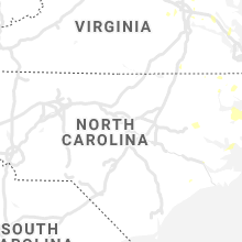
North Carolina
| Local Time | Report Details |
|---|---|
| 2:51 PM EDT | Trees down on croatan lane and perrytown loop road. time estimated by rada in craven county NC, 74.9 miles NE of Wilmington, NC |
| 3:20 PM EDT | Quarter sized hail reported near New Bern, NC, 81 miles NE of Wilmington, NC, public reported nickel to quarter sized hail in bridgeton... relayed via social media. time based on radar. |
| 4:15 PM EDT | Public reported trees down in multiple locations around creswell. time estimated by rada in washington county NC, 63.9 miles SSW of Virginia Beach, VA |
| 4:20 PM EDT | Public reports trees down on newlands rd. time estimated by rada in tyrrell county NC, 62 miles S of Virginia Beach, VA |
| 4:26 PM EDT | Tree and power lines dow in gates county NC, 32.5 miles WSW of Virginia Beach, VA |
| 4:45 PM EDT | Trees and power lines dow in chowan county NC, 43.7 miles SW of Virginia Beach, VA |
| 4:50 PM EDT | Power lines and trees dow in camden county NC, 25.9 miles SW of Virginia Beach, VA |
| 4:50 PM EDT | Trees down along horseshoe r in camden county NC, 27.1 miles SW of Virginia Beach, VA |
| 5:40 PM EDT | Tree down on waterlilly r in currituck county NC, 27 miles SSE of Virginia Beach, VA |
| 6:10 PM EDT | Amateur radio reported trees down of 6 to 14 inches in diameter. time estimated by rada in gaston county NC, 24.1 miles W of Charlotte, NC |
| 6:15 PM EDT | Amateur radio reported down tree limbs up to 6 inches in diamete in gaston county NC, 15.8 miles WNW of Charlotte, NC |
| 6:20 PM EDT | Amateur radio reported broken tree limbs up to 3 inches in diameter on main st & n liberty s in gaston county NC, 20.7 miles W of Charlotte, NC |
| 6:40 PM EDT | Amateur radio reported trees and power line down in lowell n in gaston county NC, 15.2 miles WNW of Charlotte, NC |
| 6:45 PM EDT | Public reported numerous large branches down along gum branch roa in mecklenburg county NC, 8.3 miles NW of Charlotte, NC |
| 7:01 PM EDT | Amateur radio reported down tree limb 8 inch diamete in mecklenburg county NC, 7.4 miles SE of Charlotte, NC |
| 7:20 PM EDT | County official reported tree down near nc-200 & mount pleasant rd. time estimated by rada in cabarrus county NC, 21.3 miles ENE of Charlotte, NC |
| 7:33 PM EDT | Tree dow in wilkes county NC, 65.5 miles ESE of Bristol, TN |
| 7:33 PM EDT | Tree down on airport roa in wilkes county NC, 67.3 miles ESE of Bristol, TN |
| 7:33 PM EDT | Tree dow in wilkes county NC, 64.6 miles ESE of Bristol, TN |
| 7:35 PM EDT | Awos station kukf north wilkesbor in wilkes county NC, 67.6 miles ESE of Bristol, TN |
| 7:55 PM EDT | Numerous trees reported down across stanly count in stanly county NC, 35.4 miles ENE of Charlotte, NC |
| 8:27 PM EDT | 911 center reported large tree limbs down on powerlines in beargras in martin county NC, 87.8 miles E of Raleigh, NC |
| 8:40 PM EDT | Martin co 911 center reported a large tree down on wildcat r in martin county NC, 83.4 miles E of Raleigh, NC |
| 8:58 PM EDT | Tree down on old river rd and poplar s in moore county NC, 51.8 miles SW of Raleigh, NC |
| 8:59 PM EDT | Tree down on nc24-2 in moore county NC, 50.8 miles SW of Raleigh, NC |
| 9:07 PM EDT | Tree down on bennett r in richmond county NC, 60 miles E of Charlotte, NC |
| 9:08 PM EDT | Tree down in ellerbe on hwy 7 in richmond county NC, 61.7 miles E of Charlotte, NC |
| 9:14 PM EDT | Tree down in derby... n in richmond county NC, 68.6 miles E of Charlotte, NC |
South Carolina
| Local Time | Report Details |
|---|---|
| 3:10 PM EDT | Law enforcement reported a tree down on antreville hwy. time estimated by radar in anderson county SC, 35.9 miles S of Greenville, SC |
| 3:10 PM EDT | Law enforcement reported a tree down on antreville hwy. time estimated by radar in anderson county SC, 35.9 miles S of Greenville, SC |
| 3:10 PM EDT | Law enforcement reported a tree down on antreville hwy. time estimated by radar in anderson county SC, 35.9 miles S of Greenville, SC |
| 3:15 PM EDT | Anderson county 911 call center reported trees down on us-76. time estimated by rada in anderson county SC, 24.2 miles S of Greenville, SC |
| 3:15 PM EDT | Anderson county 911 call center reported trees down on level land rd & bear creek rd. time estimated by rada in anderson county SC, 32 miles S of Greenville, SC |
| 3:30 PM EDT | Law enforcement reported tree down on roadway. time estimated by rada in greenville county SC, 27.6 miles SE of Greenville, SC |
| 3:50 PM EDT | Law enforcement reported tree down on roadway. time estimated by rada in greenville county SC, 26.4 miles SE of Greenville, SC |
Nebraska
| Local Time | Report Details |
|---|---|
| 2:58 PM CDT | * delayed report * time estimated from radar manufactured home on temporary supports knocked off supports and roof was removed and destroye in cedar county NE, 72.5 miles E of Oneill, NE |
| 3:39 PM CDT | Half Dollar sized hail reported near Osmond, NE, 58.3 miles E of Oneill, NE |
| 4:13 PM CDT | Multiple reports from public of 60 mph gusts in howell in colfax county NE, 63.5 miles WNW of Omaha, NE |
| 4:20 PM CDT | 3 inch tree limb down in front yar in polk county NE, 44.9 miles ENE of Grand Island, NE |
| 4:37 PM CDT | 50-60 mph estimated gusts. sycamore limbs broken out of tree in dodge county NE, 40.8 miles WNW of Omaha, NE |
| 5:22 PM CDT | At lincoln airport in lancaster county NE, 50.9 miles WSW of Omaha, NE |
| 5:40 PM CDT | At crete municipal airpor in saline county NE, 67.7 miles SW of Omaha, NE |
| 5:53 PM CDT | Quarter sized hail reported near Roca, NE, 59.8 miles SW of Omaha, NE |
| 5:55 PM CDT | Ping Pong Ball sized hail reported near Cortland, NE, 65.1 miles SW of Omaha, NE |
| 5:55 PM CDT | Em reports downed power lines and large tree limbs broke in gage county NE, 65.6 miles SW of Omaha, NE |
| 5:55 PM CDT | Hen Egg sized hail reported near Cortland, NE, 65.6 miles SW of Omaha, NE, some roof damage... vehicle damage... and crop damage. |
Indiana
| Local Time | Report Details |
|---|---|
| 3:00 PM CDT | Trained spotter reports tree damage along in-130 near wheeler. time estimated by rada in porter county IN, 34.5 miles SE of Chicago, IL |
| 7:01 PM EDT | Multiple tree limbs dow in vigo county IN, 57.9 miles E of Mattoon, IL |
| 9:00 PM EDT | Window blown in at iu arnett hospital. time estimated by rada in tippecanoe county IN, 55.6 miles NW of Indianapolis, IN |
Iowa
| Local Time | Report Details |
|---|---|
| 3:09 PM CDT | Storm report from em regarding a trained spotter that reported a tree with several large branches off... along with corn stocks being blown dow in des moines county IA, 37.7 miles NE of Kahoka, MO |
| 3:10 PM CDT | Report from a trained spotter that there were some large tree limbs snapped... along with many smaller limb in des moines county IA, 37.2 miles NE of Kahoka, MO |
| 4:25 PM CDT | Several 3 inch tree limbs are being snapped off trees. estimated wind speed at 60 mp in lee county IA, 14.3 miles E of Kahoka, MO |
Missouri
| Local Time | Report Details |
|---|---|
| 5:20 PM CDT | Barton county electric coop reporting 2 broken power poles due to high winds southeast of lamar. time estimate in barton county MO, 55.8 miles WNW of Springfield, MO |
| 6:45 PM CDT | Several large tree limbs snapped off on highway u near highway j. via twitte in lincoln county MO, 47.5 miles WNW of Saint Louis, MO |
Oklahoma
| Local Time | Report Details |
|---|---|
| 6:17 PM CDT | Quarter sized hail reported near Texhoma, OK, 83.6 miles N of Amarillo, TX |
| 8:20 PM CDT | Storm damage reported in texas county OK, 96.9 miles N of Amarillo, TX |
| 8:25 PM CDT | Storm damage reported in texas county OK, 94.9 miles SSW of Garden City, KS |
| 10:21 PM CDT | Golf Ball sized hail reported near Arnett, OK, 31 miles SW of Woodward, OK, mping report |
| 10:22 PM CDT | Golf Ball sized hail reported near Shattuck, OK, 38.7 miles WSW of Woodward, OK |
Texas
| Local Time | Report Details |
|---|---|
| 7:00 PM CDT | Quarter sized hail reported near Spearman, TX, 76.8 miles NNE of Amarillo, TX |
| 7:08 PM CDT | The public estimated a 70 mph wind gust in the lake view area of san angel in tom green county TX, 76.9 miles SSW of Abilene, TX |
| 7:08 PM CDT | Quarter sized hail reported near San Angelo, TX, 76.9 miles SSW of Abilene, TX, the public reported quarter size hail covering the ground in the lake view area of san angelo. |
| 7:12 PM CDT | A ham radio operator estimated a wind gust to 60 mph at buffalo height in tom green county TX, 80.8 miles SW of Abilene, TX |
| 7:15 PM CDT | The public reported a roof blown off a home 3 blocks east of coliseum drive along 41st street in san angel in tom green county TX, 77.5 miles SSW of Abilene, TX |
| 7:25 PM CDT | Tennis Ball sized hail reported near Stratford, TX, 61.9 miles N of Amarillo, TX |
| 7:26 PM CDT | A national weather service employee estimated a 70 mph wind gus in tom green county TX, 81.5 miles SW of Abilene, TX |
| 7:26 PM CDT | A national weather service employee estimated a 60 mph wind gus in tom green county TX, 82.9 miles SSW of Abilene, TX |
| 7:31 PM CDT | Quarter sized hail reported near San Angelo, TX, 81.1 miles SSW of Abilene, TX |
| 7:37 PM CDT | Tea Cup sized hail reported near Vega, TX, 30.9 miles W of Amarillo, TX |
| 7:38 PM CDT | Ping Pong Ball sized hail reported near Spearman, TX, 81.5 miles NNE of Amarillo, TX, ping ball hail reported with photo at intersection of highway 15 and county road 28 |
| 7:39 PM CDT | Storm damage reported in oldham county TX, 33.2 miles NW of Amarillo, TX |
| 7:42 PM CDT | Golf Ball sized hail reported near , , 39.6 miles NW of Amarillo, TX |
| 7:49 PM CDT | Hen Egg sized hail reported near Waka, TX, 86.1 miles NNE of Amarillo, TX |
| 7:50 PM CDT | Tennis Ball sized hail reported near Vega, TX, 31.6 miles W of Amarillo, TX |
| 7:51 PM CDT | Half Dollar sized hail reported near Vega, TX, 33.8 miles W of Amarillo, TX |
| 7:51 PM CDT | Asos station ksjt san angel in tom green county TX, 86.7 miles SSW of Abilene, TX |
| 7:51 PM CDT | Hen Egg sized hail reported near Ozona, TX, 86.2 miles SE of Odessa, TX |
| 7:54 PM CDT | Semi truck flipped on interstate 40 at mile marker 42 in oldham county TX, 28.1 miles W of Amarillo, TX |
| 7:54 PM CDT | Hen Egg sized hail reported near Wildorado, TX, 28.1 miles W of Amarillo, TX |
| 7:56 PM CDT | Multiple semi trucks flipped at mile marker 35 on interstate 40. time of event estimated from rada in oldham county TX, 35 miles W of Amarillo, TX |
| 8:00 PM CDT | Storm damage reported in moore county TX, 46.1 miles NNW of Amarillo, TX |
| 8:07 PM CDT | Storm damage reported in potter county TX, 15.6 miles NNW of Amarillo, TX |
| 8:15 PM CDT | Half Dollar sized hail reported near Sanford, TX, 38.1 miles NNE of Amarillo, TX, picture of half dollar size hail on facebook. |
| 8:15 PM CDT | Storm damage reported in moore county TX, 32.8 miles NNE of Amarillo, TX |
| 8:21 PM CDT | Hen Egg sized hail reported near Perryton, TX, 87.3 miles NNE of Amarillo, TX |
| 8:24 PM CDT | Quarter sized hail reported near Fritch, TX, 31.9 miles NNE of Amarillo, TX, time estimated from radar |
| 8:27 PM CDT | Storm damage reported in hutchinson county TX, 48.7 miles NNE of Amarillo, TX |
| 8:27 PM CDT | Storm damage reported in potter county TX, 9.2 miles N of Amarillo, TX |
| 8:28 PM CDT | Quarter sized hail reported near Fritch, TX, 32.6 miles NNE of Amarillo, TX |
| 8:32 PM CDT | Asos station ksjt san angel in tom green county TX, 86.7 miles SSW of Abilene, TX |
| 8:34 PM CDT | Tennis Ball sized hail reported near Perryton, TX, 78.8 miles W of Woodward, OK, public report relayed by broadcast media |
| 8:40 PM CDT | Spotter indicated trees were bending nearly parallel to the ground during peak winds in carson county TX, 33.2 miles NNE of Amarillo, TX |
| 9:02 PM CDT | Storm damage reported in hansford county TX, 87.6 miles NNE of Amarillo, TX |
| 9:09 PM CDT | Storm damage reported in armstrong county TX, 24.6 miles SE of Amarillo, TX |
| 9:15 PM CDT | Storm damage reported in armstrong county TX, 24.6 miles SE of Amarillo, TX |
| 9:35 PM CDT | Near zero visibility due to wind driven rai in ochiltree county TX, 78.1 miles W of Woodward, OK |
| 9:41 PM CDT | Quarter sized hail reported near Canadian, TX, 56.3 miles WSW of Woodward, OK |
| 10:15 PM CDT | Half Dollar sized hail reported near Odessa, TX, 0.3 miles E of Odessa, TX |
| 10:17 PM CDT | Golf Ball sized hail reported near Higgins, TX, 40.4 miles WSW of Woodward, OK |
| 10:18 PM CDT | Quarter sized hail reported near Odessa, TX, 4.3 miles NNW of Odessa, TX |
| 10:25 PM CDT | Storm damage reported in lamb county TX, 57.7 miles NW of Lubbock, TX |
| 10:40 PM CDT | Storm damage reported in midland county TX, 12.5 miles ENE of Odessa, TX |
| 10:43 PM CDT | Storm damage reported in lamb county TX, 57.7 miles NW of Lubbock, TX |
| 10:45 PM CDT | Storm damage reported in cochran county TX, 51.8 miles W of Lubbock, TX |
| 10:46 PM CDT | Multiple power lines snapped in half and brick fence posts blown down near the intersection of sh158 and sh191 in midland county TX, 15.9 miles NE of Odessa, TX |
| 11:10 PM CDT | Powerlines knocked down in the cit in lamb county TX, 35.4 miles NW of Lubbock, TX |
| 11:30 PM CDT | Storm damage reported in cochran county TX, 45.7 miles WSW of Lubbock, TX |
| 11:40 PM CDT | Storm damage reported in hockley county TX, 29.4 miles W of Lubbock, TX |
| 11:45 PM CDT | Storm damage reported in hockley county TX, 18.1 miles W of Lubbock, TX |
| 12:00 AM CDT | Powerline down near 31st st. and peoria av in lubbock county TX, 3 miles WSW of Lubbock, TX |
| 12:05 AM CDT | Storm damage reported in crosby county TX, 39.8 miles E of Lubbock, TX |
| 12:05 AM CDT | Storm damage reported in lubbock county TX, 16.3 miles SW of Lubbock, TX |
| 12:17 AM CDT | Storm damage reported in dawson county TX, 48.3 miles SSW of Lubbock, TX |
| 12:19 AM CDT | Storm damage reported in lynn county TX, 18.3 miles S of Lubbock, TX |
| 12:25 AM CDT | Storm damage reported in dawson county TX, 48.3 miles SSW of Lubbock, TX |
| 12:55 AM CDT | Storm damage reported in dawson county TX, 58.2 miles S of Lubbock, TX |
| 1:05 AM CDT | Measured at the hefner station of the west texas mesone in knox county TX, 65.6 miles WSW of Wichita Falls, TX |
| 1:10 AM CDT | Storm damage reported in borden county TX, 62.7 miles SSE of Lubbock, TX |
| 1:15 AM CDT | Storm damage reported in martin county TX, 38.9 miles NNE of Odessa, TX |
| 1:25 AM CDT | Storm damage reported in borden county TX, 60.4 miles SE of Lubbock, TX |
| 1:33 AM CDT | Storm damage reported in howard county TX, 47.3 miles ENE of Odessa, TX |
| 2:10 AM CDT | Snyder 3e mesonet in scurry county TX, 67.7 miles WNW of Abilene, TX |
| 2:24 AM CDT | Mesonet station 92 clyde/callahan count in callahan county TX, 12.6 miles ESE of Abilene, TX |
| 2:36 AM CDT | Mesonet station 97 throckmorton 1s in throckmorton county TX, 59.1 miles NNE of Abilene, TX |
Florida
| Local Time | Report Details |
|---|---|
| 8:07 PM EDT | Orange county fire rescue reports tree down near the intersection of lake margaret and conway roa in orange county FL, 3.5 miles SE of Orlando, FL |
| 8:17 PM EDT | Relayed report from orange county fr reports tree down near curry ford road and chickasaw trai in orange county FL, 6.8 miles ESE of Orlando, FL |
| 8:21 PM EDT | Relayed from orange county fr of tree down near green meadow lan in orange county FL, 6.7 miles E of Orlando, FL |
| 10:20 PM EDT | Kxmr measured a wind gust of 60 mph/52 kt from the wes in brevard county FL, 49.3 miles E of Orlando, FL |
Kansas
| Local Time | Report Details |
|---|---|
| 7:24 PM CDT | Storm damage reported in norton county KS, 73 miles NNW of Hays, KS |
| 7:54 PM CDT | 57.5 mph at pws station kkskansa2 in phillips county KS, 55.6 miles N of Hays, KS |
New Mexico
| Local Time | Report Details |
|---|---|
| 8:11 PM MDT | Half Dollar sized hail reported near Portales, NM, 72.2 miles SSE of Tucumcari, NM |
| 8:13 PM MDT | Hen Egg sized hail reported near Portales, NM, 72.4 miles SSE of Tucumcari, NM |
| 8:16 PM MDT | Ping Pong Ball sized hail reported near Portales, NM, 72.7 miles SSE of Tucumcari, NM |
| 8:16 PM MDT | Ping Pong Ball sized hail reported near Portales, NM, 72.1 miles SSE of Tucumcari, NM |
| 8:18 PM MDT | Quarter sized hail reported near Portales, NM, 72.9 miles SSE of Tucumcari, NM |
| 8:36 PM MDT | Tennis Ball sized hail reported near Portales, NM, 72.2 miles SSE of Tucumcari, NM |
| 9:15 PM MDT | Quarter sized hail reported near Causey, NM, 75.1 miles WNW of Lubbock, TX |
Connect with Interactive Hail Maps