

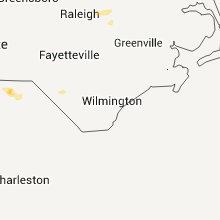
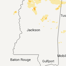
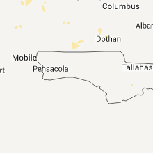
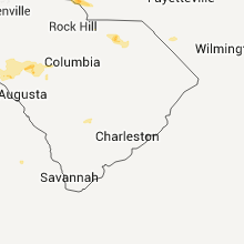
Hail Map for Friday, June 24, 2011

Number of Impacted Households on 6/24/2011
0
Impacted by 1" or Larger Hail
0
Impacted by 1.75" or Larger Hail
0
Impacted by 2.5" or Larger Hail
Square Miles of Populated Area Impacted on 6/24/2011
0
Impacted by 1" or Larger Hail
0
Impacted by 1.75" or Larger Hail
0
Impacted by 2.5" or Larger Hail


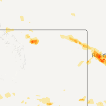


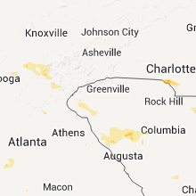

Cities Most Affected by Hail Storms of 6/24/2011
| Hail Size | Demographics of Zip Codes Affected | ||||||
|---|---|---|---|---|---|---|---|
| City | Count | Average | Largest | Pop Density | House Value | Income | Age |
| Rapid City, SD | 8 | 2.09 | 3.00 | 247 | $92k | $37.1k | 37.2 |
| Spearfish, SD | 2 | 2.38 | 3.00 | 62 | $98k | $30.2k | 38.6 |
| Dix, NE | 1 | 2.75 | 2.75 | 1 | $30k | $32.0k | 42.7 |
| Sundance, WY | 1 | 2.00 | 2.00 | 1 | $87k | $39.7k | 47.3 |
| Sidney, NE | 1 | 1.75 | 1.75 | 18 | $61k | $34.3k | 38.2 |
| Drew, MS | 1 | 1.75 | 1.75 | 22 | $42k | $20.7k | 31.2 |
| Hermosa, SD | 1 | 1.75 | 1.75 | 3 | $127k | $35.4k | 44.4 |
| Hayes Center, NE | 1 | 1.75 | 1.75 | 1 | $34k | $26.9k | 47.0 |
| Hulett, WY | 1 | 1.75 | 1.75 | 1 | $64k | $28.0k | 43.7 |
| Vale, SD | 1 | 1.75 | 1.75 | 2 | $28k | $33.5k | 47.5 |
| Guernsey, WY | 1 | 1.75 | 1.75 | 0 | $68k | $31.9k | 46.2 |
| Sturgis, SD | 1 | 1.75 | 1.75 | 15 | $79k | $34.9k | 44.7 |
| Charlotte, NC | 1 | 1.75 | 1.75 | 1859 | $84k | $38.8k | 30.2 |
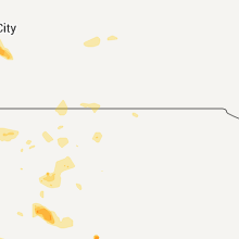
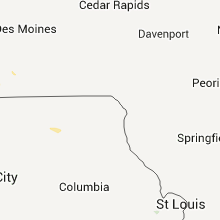
Hail and Wind Damage Spotted on 6/24/2011
Filter by Report Type:Hail ReportsWind Reports
States Impacted
New Jersey, Tennessee, Florida, Alabama, Mississippi, Pennsylvania, South Carolina, Georgia, North Carolina, Virginia, New York, Wyoming, South Dakota, Montana, Nebraska, Utah, Colorado, MissouriNew Jersey
| Local Time | Report Details |
|---|---|
| 4:15 PM UTC | Large sign knocked down... 100 year old tree down on diner property on route 7 in ocean county NJ, 43.5 miles S of Brooklyn, NY |
| 4:35 PM UTC | Quarter sized hail reported near Brick, NJ, 43.5 miles S of Brooklyn, NY |
| 6:15 PM UTC | Power outage of 2000 to 5000 in ocean county NJ, 66.2 miles S of Brooklyn, NY |
| 8:45 PM UTC | Numerous trees and wires down reported throughout the count in mercer county NJ, 50.1 miles SW of Brooklyn, NY |
Tennessee
| Local Time | Report Details |
|---|---|
| 4:52 PM UTC | A few trees down. reported by spotter/ham radio operato in monroe county TN, 41.4 miles SSW of Knoxville, TN |
| 5:57 PM UTC | Quarter sized hail reported near Altamont, TN, 35.6 miles NW of Chattanooga, TN |
| 5:58 PM UTC | A few trees down between coalmont and tracy cit in grundy county TN, 29.1 miles NW of Chattanooga, TN |
| 6:10 PM UTC | Quarter sized hail reported near Manchester, TN, 48 miles WNW of Chattanooga, TN, spotter at main entrance to aedc reported quarter size hail. |
| 6:19 PM UTC | One tree down across fredonia road. reported by dispatc in sequatchie county TN, 27.8 miles NNW of Chattanooga, TN |
| 6:19 PM UTC | Quarter sized hail reported near Dunlap, TN, 27.8 miles NNW of Chattanooga, TN, quarter sized hail on and along fredonia road. reported by dispatch. |
| 6:20 PM UTC | Quarter sized hail reported near Manchester, TN, 48.5 miles WNW of Chattanooga, TN, quarter size hail at aedc just east of tullahoma. |
| 6:45 PM UTC | A few trees down in chattanooga. reported by dispatc in hamilton county TN, 3.2 miles ENE of Chattanooga, TN |
| 7:05 PM UTC | Numerous trees and powerlines down in the chattanooga area. reported by dispatc in hamilton county TN, 3.2 miles ENE of Chattanooga, TN |
| 7:15 PM UTC | Quarter sized hail reported near Etowah, TN, 48.8 miles ENE of Chattanooga, TN, quarter sized hail near etowah. reported by dispatch. |
| 11:20 AM UTC | Quarter sized hail reported near Samburg, TN, 49.4 miles WNW of Mc Kenzie, TN, quarter size hail covering the ground in the town of samburg. |
| 11:53 AM UTC | Quarter sized hail reported near Troy, TN, 38.5 miles WNW of Mc Kenzie, TN, nickel to quarter size hail in the town of troy. |
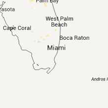
Florida
| Local Time | Report Details |
|---|---|
| 5:16 PM UTC | Storm damage reported in bay county FL, 33.6 miles E of Miramar Beach, FL |
| 5:16 PM UTC | Air traffic control reports at least one cessna aircraft flipped over and several other small aircraft moved out of place by a measured 76 mph wind gus in bay county FL, 33.6 miles E of Miramar Beach, FL |
| 7:15 PM UTC | 4 to 6 trees toppled over. pea size hail also observed. time of event based on radar imager in marion county FL, 56.4 miles NW of Orlando, FL |
| 8:15 PM UTC | There were a couple of trees reported down in the anthony are in marion county FL, 68.2 miles NW of Orlando, FL |
| 8:50 PM UTC | A couple of trees down near state road 206 and a powerline reported dow in st. johns county FL, 40.3 miles SSE of Jacksonville, FL |
| 9:45 PM UTC | 6 inch tree down across road sr434 and markham woods road in seminole county FL, 10.5 miles N of Orlando, FL |
| 9:52 PM UTC | Estimated tstm gust 50-60 mph. lots of small branches dow in seminole county FL, 11.5 miles NNE of Orlando, FL |
| 2:10 AM UTC | Tree down along county highway 183b near glendale in walton county FL, 36.6 miles NNE of Miramar Beach, FL |
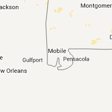
Alabama
| Local Time | Report Details |
|---|---|
| 6:47 PM UTC | Quarter sized hail reported near Huntsville, AL, 67.4 miles E of Florence, AL |
| 7:03 PM UTC | Tree on house in morgan county AL, 36.6 miles ESE of Florence, AL |
| 7:25 PM UTC | 1700 block beltline road. power lines down and trees down. roof off asian grill restauran in morgan county AL, 41.7 miles ESE of Florence, AL |
| 9:14 PM UTC | Large limbs down and scattered debris along and across hwy 17 in northern lamar county in lamar county AL, 51.6 miles NE of Starkville, MS |
| 10:11 PM UTC | Tree down at intersection of horton gap road and duck springs roa in etowah county AL, 63.7 miles NE of Birmingham, AL |
| 10:20 PM UTC | At lakeside landing on highway 23 in st. clair county AL, 29.5 miles E of Birmingham, AL |
| 10:20 PM UTC | Quarter sized hail reported near Cropwell, AL, 29.5 miles E of Birmingham, AL, at lakeside landing on highway 231. |
| 10:40 PM UTC | Storm damage reported in jefferson county AL, 17.4 miles NE of Birmingham, AL |
| 10:45 PM UTC | Trees and powerlines are down across shelby county from multiple storm in shelby county AL, 19.6 miles SE of Birmingham, AL |
| 10:50 PM UTC | Trees down in oxford near the meadowbrook subdivision. winds of 40 to 50 mph estimated from rada in calhoun county AL, 56.9 miles E of Birmingham, AL |
| 10:50 PM UTC | Tree down. time estimated from rada in shelby county AL, 13.1 miles S of Birmingham, AL |
| 10:55 PM UTC | Quarter sized hail reported near Oxford, AL, 56.9 miles E of Birmingham, AL |
| 10:55 PM UTC | Tree down on powerline near socco springs. time estimated from rada in talladega county AL, 39.1 miles E of Birmingham, AL |
| 11:07 PM UTC | Tree down near heflin along highway 7 in cleburne county AL, 69.4 miles W of Atlanta, GA |
| 11:10 PM UTC | Metal roof damaged and powerlines down. winds estimated up to 50 mph from rada in cleburne county AL, 69.4 miles W of Atlanta, GA |
| 11:10 PM UTC | Several trees reported down across southeast dale county. hail up to one-half inch in diameter reported in ech in dale county AL, 82.5 miles S of Auburn, AL |
| 11:12 PM UTC | Multiple trees down on powerlines in sylacauga. time of damage was estimated from rada in talladega county AL, 39.6 miles SE of Birmingham, AL |
| 11:35 PM UTC | Trees down along interstate 2 in cleburne county AL, 69.6 miles W of Atlanta, GA |
| 11:55 PM UTC | Large limbs and several trees down in the city of clanton on the north end of town. winds estimated at 50 to 60 mph in chilton county AL, 48 miles SSE of Birmingham, AL |
| 12:05 AM UTC | Powerlines down half a mile south of county road 9 on alabama route 1 in sumter county AL, 64.6 miles WNW of Camden, AL |
| 12:20 AM UTC | Trees down on county road 42 near derby in sumter county AL, 54.6 miles WNW of Camden, AL |
| 1:55 AM UTC | Numerous reports of trees and power lines down in the city limits of greenville in butler county AL, 40.4 miles ESE of Camden, AL |
Mississippi
| Local Time | Report Details |
|---|---|
| 7:00 PM UTC | Down trees in roads and small hail reporte in itawamba county MS, 55.7 miles SW of Florence, AL |
| 7:30 PM UTC | Several trees down in lee county MS, 55.7 miles N of Starkville, MS |
| 7:50 PM UTC | Trees down in tupelo in lee county MS, 54.9 miles N of Starkville, MS |
| 7:55 PM UTC | Estmated thunderstorm wind gust of 60 mp in pontotoc county MS, 62.1 miles N of Starkville, MS |
| 7:55 PM UTC | Several trees dow in pontotoc county MS, 62.1 miles N of Starkville, MS |
| 8:30 PM UTC | Down trees and power line in coahoma county MS, 72.1 miles SSW of Memphis, TN |
| 8:42 PM UTC | A power pole and some power lines dow in grenada county MS, 61.4 miles WNW of Starkville, MS |
| 8:45 PM UTC | Trees down and small hail reporte in tallahatchie county MS, 78.6 miles S of Memphis, TN |
| 8:45 PM UTC | Golf Ball sized hail reported near Drew, MS, 88.6 miles SSW of Memphis, TN |
| 9:05 PM UTC | Several trees down in praire communit in monroe county MS, 24.5 miles NNE of Starkville, MS |
| 9:33 PM UTC | Several trees down around the cit in lowndes county MS, 24 miles E of Starkville, MS |
| 9:55 PM UTC | Quarter sized hail reported near McCool, MS, 42.6 miles WSW of Starkville, MS |
| 10:00 PM UTC | Quarter sized hail reported near Louisville, MS, 29.4 miles SW of Starkville, MS |
| 10:20 PM UTC | Quarter sized hail reported near Noxapater, MS, 36.3 miles SSW of Starkville, MS |
| 10:32 PM UTC | Trees down blocking roads just south of philadelphia. one on highway 19s and the other on lakeview dr on tucker reservatio in neshoba county MS, 53.6 miles SSW of Starkville, MS |
| 10:45 PM UTC | Trees and limbs down along highway 491 in hous in neshoba county MS, 58.5 miles S of Starkville, MS |
| 11:00 PM UTC | Quarter sized hail reported near Carthage, MS, 49.5 miles ENE of Jackson, MS |
| 11:52 PM UTC | Large pine tree down on highway 496 in the alamucha communit in lauderdale county MS, 74.1 miles WNW of Camden, AL |
Pennsylvania
| Local Time | Report Details |
|---|---|
| 7:00 PM UTC | A couple of trees down in monroe county PA, 38.9 miles SE of Scranton, PA |
| 7:09 PM UTC | A couple of trees down. a couple of homes struck by lightning in the county... but no damage reporte in monroe county PA, 37.8 miles SE of Scranton, PA |
South Carolina
| Local Time | Report Details |
|---|---|
| 7:10 PM UTC | Trees down off east greenvil in anderson county SC, 21.6 miles S of Greenville, SC |
| 8:10 PM UTC | 2 trees down on power lines north of townvill in oconee county SC, 22.9 miles SW of Greenville, SC |
| 4:20 PM EDT | Schp reports downed tree in centerville rd in anderson county SC, 21.3 miles SSW of Greenville, SC |
| 8:45 PM UTC | Police report 5 trees dow in anderson county SC, 21.6 miles S of Greenville, SC |
| 9:15 PM UTC | Large tree limbs down near chappell in newberry county SC, 49.9 miles N of Augusta, GA |
| 9:44 PM UTC | Schp reports trees down on highway 391 at the bridg in saluda county SC, 47.8 miles NNE of Augusta, GA |
| 9:50 PM UTC | Schp reported trees down on holley ferry rd in saluda county SC, 46.8 miles NE of Augusta, GA |
| 10:00 PM UTC | Trees down on walter gulledge rd. time estimated in chesterfield county SC, 48.3 miles SE of Charlotte, NC |
| 10:10 PM UTC | Large tree limbs and power lines down on fed rivers lane. time estimate in chesterfield county SC, 52.6 miles SE of Charlotte, NC |
| 10:15 PM UTC | Schp reports tree down along callison rd and bold spring rd in greenwood county SC, 37 miles NNW of Augusta, GA |
| 10:15 PM UTC | Schp reports tree down near scotts ferry rd and highway 25 in greenwood county SC, 38.2 miles N of Augusta, GA |
| 10:15 PM UTC | Schp reported trees down at bates st and church st in batesburg in saluda county SC, 37.6 miles NE of Augusta, GA |
| 10:20 PM UTC | Public reported trees down on highway 39 south of chappell in saluda county SC, 48.1 miles N of Augusta, GA |
| 10:45 PM UTC | Trees down along us hwy 1 between mcbee and patrick. hail also fell...but size unknow in chesterfield county SC, 62 miles SE of Charlotte, NC |
| 10:55 PM UTC | Trees down on shealy rd in lexington county SC, 39.1 miles NE of Augusta, GA |
| 11:05 PM UTC | Several powerlines down and damage to a few structures on spring valley rd. time of event estimated by rada in darlington county SC, 70.8 miles SE of Charlotte, NC |
| 11:05 PM UTC | Tree fell onto car at intersection of patrtick hwy and e old camden rd. time of event estimated by rada in darlington county SC, 69.8 miles SE of Charlotte, NC |
| 11:15 PM UTC | Tree was reportedly in roadway at intersection of north center road and highway 1 in darlington county SC, 73.9 miles SE of Charlotte, NC |
| 11:22 PM UTC | The awos at darlington county jetport measured a peak wind of 62 mp in darlington county SC, 75.7 miles SE of Charlotte, NC |
| 11:22 PM UTC | Trees reported down along troy west rd in mccormick county SC, 33 miles NNW of Augusta, GA |
| 11:30 PM UTC | Schp reported trees down on highway 302 near edisto river bridge in lexington county SC, 43.4 miles ENE of Augusta, GA |
| 11:35 PM UTC | Reported powerlines down on n main street in darlington. time of event estimated by rada in darlington county SC, 77.8 miles N of Charleston, SC |
| 12:07 AM UTC | Several 5 to 8 inch limbs blown down. time estimated based off rada in marlboro county SC, 82.9 miles ESE of Charlotte, NC |
| 2:18 AM UTC | Half a dozen trees down across the azalea park area in summervill in dorchester county SC, 15.6 miles SW of Charleston, SC |
| 3:00 AM UTC | Several trees were downed by thunderstorm winds in the carlton place subdivision. time estimated based on rada in berkeley county SC, 17 miles S of Charleston, SC |
Georgia
| Local Time | Report Details |
|---|---|
| 7:10 PM UTC | Quarter sized hail reported near , , 59 miles NNE of Atlanta, GA, a small and brief amount of quarter-sized hail on the northwest side of dahlonega. most other hail was nickel-sized on north and northeast side of town. |
| 7:15 PM UTC | Tree down on longbranch road and ga 115 in lumpkin county GA, 59.7 miles NNE of Atlanta, GA |
| 7:30 PM UTC | Catoosa county 911 relayed reports of a few downed trees and a few downed powerlines in the northwestern portion of the count in catoosa county GA, 7.2 miles SSE of Chattanooga, TN |
| 7:30 PM UTC | One tree and one power line dow in catoosa county GA, 7.2 miles SSE of Chattanooga, TN |
| 7:35 PM UTC | Gilmer county emergency management relayed reports of 6-7 downed tree in gilmer county GA, 54.4 miles ESE of Chattanooga, TN |
| 7:43 PM UTC | One power line down. 4-5 trees dow in walker county GA, 10.8 miles S of Chattanooga, TN |
| 7:43 PM UTC | One power line down. three trees dow in walker county GA, 10.8 miles S of Chattanooga, TN |
| 8:15 PM UTC | Dade county 911 reports 4-5 downed trees in the poplar springs road are in dade county GA, 18.3 miles SW of Chattanooga, TN |
| 9:04 PM UTC | Chattooga county emergency management relayed reports of 2 downed tree in chattooga county GA, 34.9 miles S of Chattanooga, TN |
| 9:14 PM UTC | Floyd county 911 relayed reports of at least 9 downed tree in floyd county GA, 55.4 miles S of Chattanooga, TN |
| 9:14 PM UTC | Floyd county 911 relayed reports of at least 9 downed tree in floyd county GA, 56.6 miles S of Chattanooga, TN |
| 10:07 PM UTC | Three trees down...mostly 3 to 6 miles west of woodstoc in cherokee county GA, 26.3 miles NNW of Atlanta, GA |
| 10:13 PM UTC | Tree down on a home on cherokee driv in douglas county GA, 20.7 miles W of Atlanta, GA |
| 10:15 PM UTC | One tree dow in cobb county GA, 22.9 miles NW of Atlanta, GA |
| 11:08 PM UTC | Tree on a car on bomar roa in douglas county GA, 19.4 miles WSW of Atlanta, GA |
| 11:26 PM UTC | Quarter sized hail reported near Tallapoosa, GA, 52.4 miles W of Atlanta, GA, quarter sized hail reported on jacksonville road. |
| 11:38 PM UTC | 6-10 trees down countywid in carroll county GA, 41.4 miles WSW of Atlanta, GA |
| 12:12 AM UTC | 911 center reports that 11 trees were down across the county. ten of the events occurred in the 812 pm edt to 848 pm edt time fram in coweta county GA, 35.2 miles SW of Atlanta, GA |
North Carolina
| Local Time | Report Details |
|---|---|
| 7:12 PM UTC | Quarter sized hail reported near Bryson City, NC, 34.5 miles S of Knoxville, TN, up to 1 inch hail at the cheoah dam. |
| 7:20 PM UTC | Several trees down. reported by dispatc in clay county NC, 63.3 miles S of Knoxville, TN |
| 8:10 PM UTC | Trees and powerlines down near taylor store road and nc 58...causing some structural damage to home in nash county NC, 39.5 miles ENE of Raleigh, NC |
| 8:35 PM UTC | Powerlines and tree down at intersection of beulah church rd and old whiteville rd. time of event estimated by rada in robeson county NC, 62.4 miles WNW of Wilmington, NC |
| 8:52 PM UTC | Powerlines down on residence located on long branch dr. time of event estimated by rada in robeson county NC, 62.9 miles WNW of Wilmington, NC |
| 9:36 PM UTC | Powerlines down shopton rd and skycrest lane area in mecklenburg county NC, 5.9 miles SW of Charlotte, NC |
| 9:36 PM UTC | Quarter sized hail reported near Charlotte, NC, 5.1 miles SW of Charlotte, NC, shopton rd area |
| 9:36 PM UTC | Golf Ball sized hail reported near Charlotte, NC, 5.2 miles SW of Charlotte, NC, tyvola rd and i-77 |
| 9:42 PM UTC | Quarter sized hail reported near Charlotte, NC, 4.1 miles SSW of Charlotte, NC, up to 1 inch hail at arrowood blvd and i-77. |
| 9:51 PM UTC | Quarter sized hail reported near Charlotte, NC, 3.8 miles SW of Charlotte, NC, at wcnc studio |
| 9:55 PM UTC | Relayed report from charlotte fd of lines along 7600 block of park rd in mecklenburg county NC, 6.5 miles SSW of Charlotte, NC |
| 10:02 PM UTC | Quarter sized hail reported near Matthews, NC, 8.3 miles SE of Charlotte, NC, sardis rd and independence blvd |
| 10:09 PM UTC | Powerlines down west matthews and n ames st in mecklenburg county NC, 9.7 miles SE of Charlotte, NC |
| 2:26 AM UTC | Trees and powerlines down on hicksboro roa in vance county NC, 42 miles NNE of Raleigh, NC |
| 2:33 AM UTC | Tree down on powerlines on nutbush roa in vance county NC, 45.3 miles NNE of Raleigh, NC |
| 2:55 AM UTC | Power outages in sims due to tree limbs falling on powerlines on lamm r in wilson county NC, 35.6 miles E of Raleigh, NC |
| 3:25 AM UTC | Trees down at cross cut subdivision on the eastern shore of lake gaston near the da in halifax county NC, 66.9 miles NE of Raleigh, NC |
Virginia
| Local Time | Report Details |
|---|---|
| 7:52 PM UTC | 2 large trees down blocking portions of wolf trap r in york county VA, 36.2 miles NW of Virginia Beach, VA |
| 7:52 PM UTC | Quarter sized hail reported near Newport News, VA, 35.3 miles NW of Virginia Beach, VA |
| 7:58 PM UTC | Storm damage reported in city of newport ne county VA, 35.6 miles NW of Virginia Beach, VA |
| 8:00 PM UTC | Large limbs down in the road near patrick henry mall blocking 3 lanes of traffi in city of newport ne county VA, 34.6 miles NW of Virginia Beach, VA |
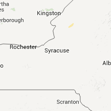
New York
| Local Time | Report Details |
|---|---|
| 8:20 PM UTC | Trees down in oneida county NY, 54.3 miles ENE of Syracuse, NY |
| 10:30 PM UTC | Trees down in town of ohi in herkimer county NY, 61.8 miles ENE of Syracuse, NY |
Wyoming
| Local Time | Report Details |
|---|---|
| 8:50 PM UTC | Quarter sized hail reported near Douglas, WY, 43.9 miles ESE of Casper, WY, a few stones up to one inch in diameter. |
| 9:23 PM UTC | Quarter sized hail reported near Wheatland, WY, 64.1 miles NNE of Laramie, WY, pea to quarter sized hail ongoing at time of report. |
| 9:45 PM UTC | Golf Ball sized hail reported near Guernsey, WY, 61.4 miles WNW of Scottsbluff, NE |
| 10:12 PM UTC | Accompanied by pea sized hai in niobrara county WY, 92.3 miles SW of Rapid City, SD |
| 11:02 PM UTC | Golf Ball sized hail reported near Hulett, WY, 48.3 miles NE of Gillette, WY, some rotation also was noted in the clouds...but has since dissipated. |
| 11:40 PM UTC | Hen Egg sized hail reported near Sundance, WY, 57.6 miles WNW of Rapid City, SD |
| 12:50 AM UTC | Quarter sized hail reported near Newcastle, WY, 48.7 miles W of Rapid City, SD |
South Dakota
| Local Time | Report Details |
|---|---|
| 9:40 PM UTC | Golf Ball sized hail reported near Sturgis, SD, 18 miles NW of Rapid City, SD |
| 9:48 PM UTC | Ping Pong Ball sized hail reported near Piedmont, SD, 14.1 miles NW of Rapid City, SD |
| 9:50 PM UTC | Quarter sized hail reported near Piedmont, SD, 17.5 miles NW of Rapid City, SD |
| 10:10 PM UTC | Golf Ball sized hail reported near Vale, SD, 35.8 miles N of Rapid City, SD |
| 10:25 PM UTC | Ping Pong Ball sized hail reported near Box Elder, SD, 8.4 miles ENE of Rapid City, SD, ellsworth afb weather |
| 10:28 PM UTC | Ping Pong Ball sized hail reported near Box Elder, SD, 8.4 miles ENE of Rapid City, SD, report from highway patrol |
| 10:30 PM UTC | Half Dollar sized hail reported near Box Elder, SD, 6.6 miles ENE of Rapid City, SD |
| 10:41 PM UTC | Quarter sized hail reported near Piedmont, SD, 18.1 miles NNW of Rapid City, SD |
| 10:45 PM UTC | Quarter sized hail reported near Piedmont, SD, 16.6 miles NNW of Rapid City, SD |
| 11:51 PM UTC | Half Dollar sized hail reported near Spearfish, SD, 48.7 miles NW of Rapid City, SD |
| 11:55 PM UTC | Tea Cup sized hail reported near Spearfish, SD, 42.4 miles WNW of Rapid City, SD |
| 12:00 AM UTC | Golf Ball sized hail reported near Spearfish, SD, 48.7 miles NW of Rapid City, SD |
| 12:20 AM UTC | Half Dollar sized hail reported near Deadwood, SD, 24.4 miles WNW of Rapid City, SD |
| 12:24 AM UTC | Kota tv observatio in butte county SD, 45.1 miles NNW of Rapid City, SD |
| 12:26 AM UTC | Buffalo aso in harding county SD, 106 miles N of Rapid City, SD |
| 12:35 AM UTC | Quarter sized hail reported near Nemo, SD, 18.2 miles WNW of Rapid City, SD |
| 12:35 AM UTC | Storm damage reported in butte county SD, 44.4 miles NNW of Rapid City, SD |
| 12:41 AM UTC | Golf Ball sized hail reported near Rapid City, SD, 13.6 miles WNW of Rapid City, SD |
| 12:45 AM UTC | Golf Ball sized hail reported near Rapid City, SD, 10.5 miles WNW of Rapid City, SD |
| 12:46 AM UTC | Quarter sized hail reported near Piedmont, SD, 14.1 miles NW of Rapid City, SD |
| 1:00 AM UTC | Storm damage reported in meade county SD, 65.9 miles NNE of Rapid City, SD |
| 1:00 AM UTC | Quarter sized hail reported near Rapid City, SD, 4 miles SSW of Rapid City, SD, dime to quarter size hail. lasted 15 minutes. |
| 1:05 AM UTC | Hen Egg sized hail reported near Rapid City, SD, 3.2 miles SSE of Rapid City, SD |
| 1:09 AM UTC | Storm damage reported in pennington county SD, 0.1 miles SSE of Rapid City, SD |
| 1:10 AM UTC | Storm damage reported in meade county SD, 36.1 miles NE of Rapid City, SD |
| 1:10 AM UTC | Storm damage reported in pennington county SD, 1.9 miles W of Rapid City, SD |
| 1:10 AM UTC | 18 inch tree uprooted. laying across power in pennington county SD, 1.9 miles W of Rapid City, SD |
| 1:10 AM UTC | Hen Egg sized hail reported near Rapid City, SD, 1.9 miles W of Rapid City, SD |
| 1:10 AM UTC | Tennis Ball sized hail reported near Rapid City, SD, 2.2 miles S of Rapid City, SD |
| 1:11 AM UTC | Ping Pong Ball sized hail reported near Rapid City, SD, 0.1 miles SSE of Rapid City, SD |
| 1:14 AM UTC | Quarter sized hail reported near Rapid City, SD, 0.1 miles SSE of Rapid City, SD, at wfo unr...which took a direct lightning strike |
| 1:15 AM UTC | Golf Ball sized hail reported near Hermosa, SD, 14.3 miles SSE of Rapid City, SD, estimated winds at 80 mph. |
| 1:15 AM UTC | Hen Egg sized hail reported near Rapid City, SD, 2.6 miles SE of Rapid City, SD |
| 1:15 AM UTC | Tea Cup sized hail reported near Rapid City, SD, 4.2 miles S of Rapid City, SD |
| 1:16 AM UTC | Golf Ball sized hail reported near Rapid City, SD, 2.2 miles SSE of Rapid City, SD |
| 1:45 AM UTC | Storm damage reported in meade county SD, 41 miles ENE of Rapid City, SD |
| 2:05 AM UTC | Quarter sized hail reported near Hermosa, SD, 31.1 miles SE of Rapid City, SD |
| 2:35 AM UTC | Storm damage reported in haakon county SD, 68.2 miles E of Rapid City, SD |
| 2:55 AM UTC | Storm damage reported in jackson county SD, 63.6 miles WSW of Pierre, SD |
| 3:05 AM UTC | Interstate 90 at mile marker 152. sign blown onto highwa in jackson county SD, 68.7 miles WSW of Pierre, SD |
| 3:20 AM UTC | Wind gusts from 56 to 75 mph between 910 pm and 940 pm mdt. sd dot observatio in jackson county SD, 50.3 miles SW of Pierre, SD |
| 3:35 AM UTC | Semi blown over on interstate 90 in jones county SD, 46.9 miles SW of Pierre, SD |
Montana
| Local Time | Report Details |
|---|---|
| 10:35 PM UTC | Fort howes raws in powder river county MT, 76.6 miles NNW of Gillette, WY |
| 10:52 PM UTC | Quarter sized hail reported near Melville, MT, 64.9 miles WNW of Billings, MT |
| 2:00 AM UTC | Quarter sized hail reported near Columbus, MT, 37.3 miles WSW of Billings, MT, in town columbus |
| 2:00 AM UTC | Quarter sized hail reported near Columbus, MT, 39.2 miles WSW of Billings, MT |
Nebraska
| Local Time | Report Details |
|---|---|
| 10:40 PM UTC | Half Dollar sized hail reported near Harrison, NE, 58.2 miles N of Scottsbluff, NE |
| 10:55 PM UTC | Quarter sized hail reported near Harrison, NE, 64.8 miles NNW of Scottsbluff, NE, duration 15 minutes. |
| 10:55 PM UTC | Quarter sized hail reported near Harrison, NE, 65.4 miles NNW of Scottsbluff, NE |
| 11:00 PM UTC | Storm damage reported in sioux county NE, 57.2 miles N of Scottsbluff, NE |
| 11:25 PM UTC | Some tree limbs knocked dow in dawes county NE, 52.4 miles NNE of Scottsbluff, NE |
| 11:39 PM UTC | Storm damage reported in dawes county NE, 62.7 miles NE of Scottsbluff, NE |
| 11:50 PM UTC | 12 inch diameter pine tree down. a few penny sized hail stone in dawes county NE, 80.1 miles NNE of Scottsbluff, NE |
| 12:02 AM UTC | Greater than 4 inch branch ripped from tree in sheridan county NE, 74 miles NE of Scottsbluff, NE |
| 12:05 AM UTC | Storm damage reported in sheridan county NE, 83.9 miles NE of Scottsbluff, NE |
| 12:08 AM UTC | 4 to 5 inch branches ripped from trees in sheridan county NE, 73.8 miles NE of Scottsbluff, NE |
| 12:13 AM UTC | Half Dollar sized hail reported near Bushnell, NE, 41.2 miles SSW of Scottsbluff, NE, half dollar sized hail was ongoing at the time of the report. |
| 12:55 AM UTC | Estimated 60 mile per hour wind gusts with penny size hai in cherry county NE, 63.1 miles WSW of Valentine, NE |
| 1:00 AM UTC | Estimated 70 mile per hour wind gust with a tree blown over and 5 to 6 inch branches snapped of in cherry county NE, 53.9 miles WSW of Valentine, NE |
| 1:04 AM UTC | Storm damage reported in cherry county NE, 53.9 miles WSW of Valentine, NE |
| 1:20 AM UTC | Storm damage reported in cherry county NE, 78.6 miles SW of Valentine, NE |
| 1:41 AM UTC | Quarter sized hail reported near Merriman, NE, 63.4 miles WSW of Valentine, NE |
| 2:10 AM UTC | Quarter sized hail reported near Lewellen, NE, 79 miles ESE of Scottsbluff, NE |
| 2:15 AM UTC | Quarter sized hail reported near Lewellen, NE, 77.1 miles WNW of North Platte, NE |
| 2:16 AM UTC | Half Dollar sized hail reported near Mitchell, NE, 6.2 miles NW of Scottsbluff, NE, half dollar sized hail was ongoing at the time of the report. |
| 2:23 AM UTC | Ping Pong Ball sized hail reported near Scottsbluff, NE, 8.2 miles N of Scottsbluff, NE |
| 2:32 AM UTC | Quarter sized hail reported near Gering, NE, 2.2 miles S of Scottsbluff, NE |
| 2:42 AM UTC | Quarter sized hail reported near Lemoyne, NE, 61.1 miles W of North Platte, NE |
| 3:00 AM UTC | Quarter sized hail reported near Bushnell, NE, 44.1 miles S of Scottsbluff, NE |
| 3:16 AM UTC | Ping Pong Ball sized hail reported near Kimball, NE, 40.2 miles S of Scottsbluff, NE |
| 3:38 AM UTC | Ping Pong Ball sized hail reported near Dix, NE, 45.2 miles SSE of Scottsbluff, NE |
| 3:55 AM UTC | Golf Ball sized hail reported near Sidney, NE, 65.2 miles NNW of Yuma, CO, 70 mph winds as well. trees down on property. |
| 4:14 AM UTC | Ping Pong Ball sized hail reported near Dix, NE, 52 miles S of Scottsbluff, NE |
| 4:25 AM UTC | Baseball sized hail reported near Dix, NE, 49.9 miles S of Scottsbluff, NE |
| 4:30 AM UTC | Tree branches down in cheyenne county NE, 48.9 miles SE of Scottsbluff, NE |
| 4:34 AM UTC | Several tree branches down due to high winds in cheyenne county NE, 47.5 miles SE of Scottsbluff, NE |
| 4:35 AM UTC | Ping Pong Ball sized hail reported near Sidney, NE, 65.2 miles NNW of Yuma, CO, some hail was quarter size. winds were 50 to 60 mph. this occurred just north of town. |
| 6:00 AM UTC | Quarter sized hail reported near Gering, NE, 2.2 miles S of Scottsbluff, NE |
| 6:32 AM UTC | Quarter sized hail reported near Elm Creek, NE, 55.3 miles WSW of Grand Island, NE |
| 7:00 AM UTC | Golf Ball sized hail reported near Hayes Center, NE, 41.2 miles S of North Platte, NE, delayed report...public reported marble and golf ball sized hail 12 miles sw of maywood early this morning |
Utah
| Local Time | Report Details |
|---|---|
| 12:30 AM UTC | Quarter sized hail reported near Lewiston, UT, 82.2 miles N of Salt Lake City, UT, report received via nssl-nws severe hazards analysis and verification project |
Colorado
| Local Time | Report Details |
|---|---|
| 6:00 AM UTC | Quarter sized hail reported near Haxtun, CO, 19.5 miles NNE of Yuma, CO |
Missouri
| Local Time | Report Details |
|---|---|
| 8:46 AM UTC | Quarter sized hail reported near Dexter, MO, 42.2 miles SSW of Cape Girardeau, MO, pea to quarter size hail |
Connect with Interactive Hail Maps