

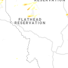
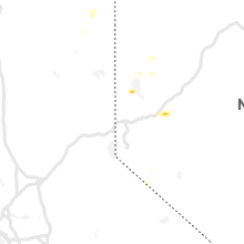
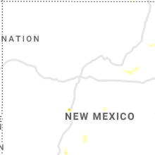
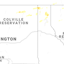
Hail Map for Wednesday, June 24, 2020

Number of Impacted Households on 6/24/2020
0
Impacted by 1" or Larger Hail
0
Impacted by 1.75" or Larger Hail
0
Impacted by 2.5" or Larger Hail
Square Miles of Populated Area Impacted on 6/24/2020
0
Impacted by 1" or Larger Hail
0
Impacted by 1.75" or Larger Hail
0
Impacted by 2.5" or Larger Hail


Cities Most Affected by Hail Storms of 6/24/2020
| Hail Size | Demographics of Zip Codes Affected | ||||||
|---|---|---|---|---|---|---|---|
| City | Count | Average | Largest | Pop Density | House Value | Income | Age |
| Otis, KS | 4 | 2.00 | 2.00 | 2 | $31k | $26.3k | 49.9 |
| Lewis, KS | 3 | 2.50 | 3.00 | 2 | $37k | $35.0k | 44.4 |
| North Platte, NE | 3 | 2.00 | 2.50 | 50 | $79k | $36.3k | 38.7 |
| Lyons, KS | 3 | 1.83 | 2.00 | 23 | $46k | $35.8k | 40.0 |
| Rush Center, KS | 1 | 2.00 | 2.00 | 3 | $31k | $31.9k | 50.1 |
| Albert, KS | 1 | 2.00 | 2.00 | 2 | $44k | $37.1k | 50.2 |
| Geneseo, KS | 1 | 1.75 | 1.75 | 3 | $26k | $26.5k | 51.4 |
| Kila, MT | 1 | 1.75 | 1.75 | 2 | $133k | $36.5k | 45.4 |
| Sutherland, NE | 1 | 1.75 | 1.75 | 3 | $74k | $38.9k | 40.6 |
| Orlando, FL | 1 | 1.75 | 1.75 | 3492 | $89k | $39.2k | 33.4 |
| Larned, KS | 1 | 1.75 | 1.75 | 16 | $52k | $34.2k | 42.2 |
Hail and Wind Damage Spotted on 6/24/2020
Filter by Report Type:Hail ReportsWind Reports
States Impacted
Mississippi, Texas, Alabama, Georgia, Washington, New Mexico, Kansas, Idaho, Oregon, Montana, Florida, Colorado, NebraskaMississippi
| Local Time | Report Details |
|---|---|
| 11:14 AM CDT | Several trees down. tree fell and damaged a carport and house. pictures and video via social medi in george county MS, 44.3 miles WNW of Mobile, AL |
| 11:58 AM CDT | A few trees were blown down... along with portions of a tin roof peeled off of a business and a home awnin in clarke county MS, 78.7 miles W of Camden, AL |
| 12:27 PM CDT | Reports of tree limbs down and traffic light not working at hwy 90 and 15th street. time estimated by rada in harrison county MS, 65 miles WSW of Mobile, AL |
| 12:30 PM CDT | Report of a light pole down on hwy 90 in gulfport. time estimated by rada in harrison county MS, 64 miles WSW of Mobile, AL |
| 12:35 PM CDT | Emergency manager reported power outages and tree daamage near 26245 hwy 15 north of diberville. trees and power lines were also damaged near big john road and 6160 kro in harrison county MS, 54 miles WSW of Mobile, AL |
| 12:44 PM CDT | Broadcast media reported several power lines down in the woolmarket area of biloxi near derouen rd and horace rushing. several trees were also reported down with eviden in harrison county MS, 55.2 miles WSW of Mobile, AL |
| 12:58 PM CDT | Fire dept reported debris along mile marker 56 and 57 on i-10 in jackson county... ms. possible tornado as fire dept. also reported possible touchdow in jackson county MS, 39.6 miles WSW of Mobile, AL |
| 1:20 PM CDT | Trees and power poles snapped. power lines down. metal wrapped around a power pole. pictures and reports via social medi in george county MS, 28.7 miles WNW of Mobile, AL |
Texas
| Local Time | Report Details |
|---|---|
| 11:50 AM CDT | Parking lot light pole blown over. time estimated from rada in nueces county TX, 11.9 miles SSE of Corpus Christi, TX |
| 11:50 AM CDT | Large tree uprooted near waldron road and don patricio road. time estimate in nueces county TX, 11.7 miles SE of Corpus Christi, TX |
Alabama
| Local Time | Report Details |
|---|---|
| 1:37 PM CDT | Several large trees snapped near zeigler blvd and cody rd. another tree down near overlook rd. traffic signals damaged. reports and pictures via social medi in mobile county AL, 9.5 miles W of Mobile, AL |
| 1:40 PM CDT | Trees down in a few spots along old shell rd. reports via social medi in mobile county AL, 7 miles W of Mobile, AL |
| 1:45 PM CDT | Trees down on both wolf ridge rd and feed mill rd. reports via social medi in mobile county AL, 6.4 miles NW of Mobile, AL |
| 1:49 PM CDT | Softwood trees snapped with large trees uprooted along kelly trai in mobile county AL, 21.4 miles NNW of Mobile, AL |
| 1:52 PM CDT | Several small pine trees snapped along celeste rd. pictures via social medi in mobile county AL, 22.9 miles NNW of Mobile, AL |
| 1:55 PM CDT | Hardwood tree limbs snapped with tree limbs on power line in mobile county AL, 23.9 miles N of Mobile, AL |
Georgia
| Local Time | Report Details |
|---|---|
| 3:30 PM EDT | One tree fell onto a powerlin in berrien county GA, 32.4 miles WSW of Douglas, GA |
| 3:35 PM EDT | Multiple trees down along overlook lan in walton county GA, 37.2 miles ENE of Atlanta, GA |
| 4:15 PM EDT | One tree down on ivy road near hwy 16 in lanier county GA, 26.3 miles SSW of Douglas, GA |
| 4:20 PM EDT | One tree down on a powerline along hutchins r in oglethorpe county GA, 71.3 miles E of Atlanta, GA |
| 4:26 PM EDT | One tree down on a powerline along union point roa in oglethorpe county GA, 71.3 miles WNW of Augusta, GA |
| 4:31 PM EDT | Quarter sized hail reported near Pelham, GA, 45.6 miles N of Tallahassee, FL, hail up to quarter size. |
| 5:20 PM EDT | One powerline down on hwy 32w. hail was also noted but the size was unknow in worth county GA, 62.8 miles WNW of Douglas, GA |
| 5:45 PM EDT | Public report via social media of trees downed in the vicinity of hoboken. time of damage based on radar dat in brantley county GA, 47.6 miles ESE of Douglas, GA |
| 6:15 PM EDT | Public report via social media of a tree and powerlines downed near the hooterville diner along u.s. highway 82. time of damge based on radar dat in brantley county GA, 62.3 miles N of Jacksonville, FL |
| 8:09 PM EDT | A tree was reported down on bascom road near lawton roa in screven county GA, 49.4 miles SSE of Augusta, GA |
Washington
| Local Time | Report Details |
|---|---|
| 1:40 PM PDT | Ping Pong Ball sized hail reported near Kettle Falls, WA, 66.7 miles ENE of Omak, WA, report from blue moose lodging along highway 395 on the west shore of lake roosevelt. |
| 1:55 PM PDT | Ping Pong Ball sized hail reported near Kettle Falls, WA, 69.1 miles ENE of Omak, WA |
| 2:10 PM PDT | Quarter sized hail reported near Metaline Falls, WA, 82.6 miles N of Spokane, WA, corrects previous hail report from 4 ese metaline falls. social media post of quarter size hail on sullivan creek and lots of pea-sized hail around the lake. little to |
New Mexico
| Local Time | Report Details |
|---|---|
| 3:00 PM MDT | Quarter sized hail reported near Mayhill, NM, 65.5 miles WSW of Roswell, NM |
| 4:45 PM MDT | Storm damage reported in sierra county NM, 77.4 miles ENE of Silver City, NM |
| 8:53 PM MDT | Elev 4115 ft rsois in dona ana county NM, 14.7 miles WNW of El Paso, TX |
Kansas
| Local Time | Report Details |
|---|---|
| 4:08 PM CDT | Hen Egg sized hail reported near Otis, KS, 28 miles SSE of Hays, KS, egg size hail reported from kake. |
| 4:11 PM CDT | Hen Egg sized hail reported near Otis, KS, 28 miles SSE of Hays, KS, quarters to eggs reported by spotter network. |
| 4:15 PM CDT | Half Dollar sized hail reported near Otis, KS, 28 miles SSE of Hays, KS, social media reports of half dollar size hail. |
| 4:19 PM CDT | Hen Egg sized hail reported near Otis, KS, 28 miles SSE of Hays, KS, social media report of egg size hail. |
| 4:27 PM CDT | Hen Egg sized hail reported near Otis, KS, 28 miles SSE of Hays, KS, social reports of continued egg size hail. |
| 4:42 PM CDT | Hen Egg sized hail reported near Albert, KS, 31.7 miles SSE of Hays, KS, social media report along hwy 96. |
| 5:20 PM CDT | Quarter sized hail reported near Geneseo, KS, 67.1 miles ESE of Hays, KS, hail the size of quarters coming down currently. |
| 5:20 PM CDT | Golf Ball sized hail reported near Geneseo, KS, 67.8 miles ESE of Hays, KS, pea to golf ball sized hail falling. not a ton but a few ping pong ball and golf ball sized pieces just started falling. |
| 5:22 PM CDT | Hen Egg sized hail reported near Rush Center, KS, 28.9 miles SSE of Hays, KS, social media report of eggs. |
| 5:33 PM CDT | Ping Pong Ball sized hail reported near Rush Center, KS, 28.9 miles SSE of Hays, KS, social report of ping pong balls. |
| 5:50 PM CDT | Golf Ball sized hail reported near Larned, KS, 40.7 miles SSE of Hays, KS |
| 5:55 PM CDT | Half Dollar sized hail reported near Rush Center, KS, 34.2 miles SSE of Hays, KS, half dollar size hail reported along with gusty winds and quite a bit of rain but not sure how much. |
| 5:56 PM CDT | Golf Ball sized hail reported near Lyons, KS, 65.9 miles NW of Wichita, KS, via social media. |
| 6:00 PM CDT | Hen Egg sized hail reported near Lyons, KS, 65.9 miles NW of Wichita, KS, kake storm chaser sent picture via twitter. time is estimated from radar. |
| 6:03 PM CDT | Golf Ball sized hail reported near Lyons, KS, 64.9 miles NW of Wichita, KS |
| 6:15 PM CDT | Quarter sized hail reported near Larned, KS, 49.3 miles SSE of Hays, KS, quarter size hail reported. |
| 6:40 PM CDT | Quarter sized hail reported near Larned, KS, 48.7 miles S of Hays, KS, spotter reported quarter size hail in town. |
| 7:00 PM CDT | Quarter sized hail reported near Lewis, KS, 61.5 miles S of Hays, KS, corrects previous hail report from 3 nnw lewis. spotter reports quarters up to 3 inch hail. |
| 7:00 PM CDT | Tea Cup sized hail reported near Lewis, KS, 61.5 miles S of Hays, KS, trained spotter reported up to 3 inch hail. |
| 7:03 PM CDT | Hen Egg sized hail reported near Lewis, KS, 64.4 miles S of Hays, KS, spotter network report of 2 inch sized hail. |
| 7:13 PM CDT | Tennis Ball sized hail reported near Lewis, KS, 65 miles S of Hays, KS, spotter network report of 2.5 inch hail. |
| 7:35 PM CDT | Quarter sized hail reported near Kinsley, KS, 74.6 miles S of Hays, KS, spotter report of quarter size hail. |
| 7:52 PM CDT | Half Dollar sized hail reported near Offerle, KS, 68.8 miles S of Hays, KS, spotter report of dollar size hail. |
| 8:00 PM CDT | Half Dollar sized hail reported near Mullinville, KS, 79 miles S of Hays, KS, spotter report of half dollar size hail. |
| 8:00 PM CDT | Barn blown down with estimated 70 mph wind gust in ford county KS, 62.6 miles E of Garden City, KS |
| 8:35 PM CDT | Quarter sized hail reported near Ford, KS, 66.3 miles ESE of Garden City, KS, storm spotter driving on hwy 400 reporting quarter size hail and winds at least 60 mph. |
| 9:10 PM CDT | Social media report of 50-60 mph wind gust in ford county KS, 68.1 miles ESE of Garden City, KS |
Idaho
| Local Time | Report Details |
|---|---|
| 2:35 PM PDT | Quarter sized hail reported near Bonners Ferry, ID, 101.2 miles NNE of Spokane, WA |
| 4:30 PM PDT | Half dozen trees damaged at the idaho club golf course. penny size hail and torrential rain as wel in bonner county ID, 68.5 miles NE of Spokane, WA |
| 4:35 PM PDT | Half Dollar sized hail reported near Sandpoint, ID, 65.7 miles NE of Spokane, WA, social media report and video of hail the size of large silver dollars. |
| 4:50 PM PDT | Quarter sized hail reported near Sandpoint, ID, 72.4 miles NE of Spokane, WA, corrects previous hail report from 9 se elmira. hail damage noted to garden. |
Oregon
| Local Time | Report Details |
|---|---|
| 4:06 PM MDT | Quarter sized hail reported near Vale, OR, 71.6 miles WNW of Boise, ID, lots of hail covering the ground causing damage to crops. report via social media |
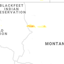
Montana
| Local Time | Report Details |
|---|---|
| 4:15 PM MDT | Golf Ball sized hail reported near Kila, MT, 20.9 miles SSW of Whitefish, MT |
| 4:25 PM MDT | Quarter sized hail reported near Kalispell, MT, 15.3 miles S of Whitefish, MT |
| 4:26 PM MDT | Quarter sized hail reported near Kalispell, MT, 13.9 miles S of Whitefish, MT |
| 4:35 PM MDT | Half Dollar sized hail reported near Whitefish, MT, 6.4 miles SSW of Whitefish, MT |
| 4:46 PM MDT | Half Dollar sized hail reported near Kalispell, MT, 14.6 miles S of Whitefish, MT |
| 4:48 PM MDT | Quarter sized hail reported near Columbia Falls, MT, 7.8 miles ESE of Whitefish, MT, cellular service is out due to hail. |
| 5:55 PM MDT | Awos station k7s1 twin bridge in madison county MT, 62.3 miles W of Bozeman, MT |
| 5:58 PM MDT | Corrects previous non-tstm wnd gst report from 8 ssw wolf creek. mesonet station 301005 siebe in lewis and clark county MT, 57 miles SW of Great Falls, MT |
| 6:50 PM MDT | Mesonet station ennm8 ennis raws. time estimated based on rada in madison county MT, 43.6 miles SW of Bozeman, MT |
| 7:36 PM MDT | Ping Pong Ball sized hail reported near Power, MT, 18.7 miles NNW of Great Falls, MT, a lot of quarter to ping pong sized hail. also reports wind shredded pine trees and a lot of branches down. |
| 7:54 PM MDT | Corrected time. reports strong winds brought rain into attic of house and knocked down trees. also reports a pile of pea sized hai in chouteau county MT, 20 miles NNE of Great Falls, MT |
| 8:00 PM MDT | Lincoln electric cooperative... inc. reported numerous locations in their service area where trees had fallen onto power lines and caused outages. locations include tow in lincoln county MT, 46.2 miles NW of Whitefish, MT |
| 8:00 PM MDT | Estimated wind gusts near 60 mph in carte in chouteau county MT, 24.8 miles NE of Great Falls, MT |
| 8:06 PM MDT | Relayed report from trained spotter of trees stripped and power outage from thunderstorm wind gust in chouteau county MT, 21.8 miles NNE of Great Falls, MT |
| 8:06 PM MDT | Wind and rain reduced visibility to less than 100 feet. reports 0.80 inches of rain in 15 minutes. also reports pea sized hai in chouteau county MT, 21.6 miles NNE of Great Falls, MT |
| 8:12 PM MDT | Reports some tree branch damage from strong winds. small hail also observed along with some water on roa in chouteau county MT, 24.8 miles NE of Great Falls, MT |
| 8:15 PM MDT | Quarter sized hail reported near Bigfork, MT, 27.2 miles SSE of Whitefish, MT |
| 8:29 PM MDT | Storm damage reported in wheatland county MT, 77.3 miles NW of Billings, MT |
| 8:37 PM MDT | Reports strong winds brought rain into attic of house and knocked down trees. also reports a pile of pea sized hai in chouteau county MT, 20 miles NNE of Great Falls, MT |
| 9:25 PM MDT | Storm damage reported in sweet grass county MT, 51.7 miles E of Bozeman, MT |
Florida
| Local Time | Report Details |
|---|---|
| 7:01 PM EDT | Branches down near hammock dunes bridge from a downburst. radar estimated tim in flagler county FL, 59.4 miles SSE of Jacksonville, FL |
| 7:20 PM EDT | Mesonet station 1334w 1.6 e palm coast (weatherstem in flagler county FL, 59.4 miles SSE of Jacksonville, FL |
| 7:20 PM EDT | Mesonet station 1334w 1.6 e palm coast (weatherstem in flagler county FL, 59.4 miles SSE of Jacksonville, FL |
| 7:22 PM EDT | Tree down on creekside drive in grand have in flagler county FL, 66 miles SSE of Jacksonville, FL |
| 7:22 PM EDT | Tree down across creekside dr blocking the roa in flagler county FL, 60.9 miles SSE of Jacksonville, FL |
| 7:55 PM EDT | Quarter sized hail reported near Kissimmee, FL, 21 miles SW of Orlando, FL, quarter sized hail reported in four corners... osceola county. |
| 8:07 PM EDT | Wind gust of 52 knots/60 mph from the southeas in seminole county FL, 18.6 miles NNE of Orlando, FL |
| 8:34 PM EDT | Golf Ball sized hail reported near Orlando, FL, 7.5 miles NNW of Orlando, FL, report of golf ball sized hail near state road 434 and maitland blvd from spectrum news 13. |
| 8:39 PM EDT | Quarter sized hail reported near Orlando, FL, 7.7 miles NNW of Orlando, FL, quarter sized hail near maitland blvd and magnolia homes road... altamonte springs |
| 8:47 PM EDT | Quarter sized hail reported near Maitland, FL, 7.1 miles N of Orlando, FL, quarter sized hail started falling at 843 pm and continued through 847 pm. |
Colorado
| Local Time | Report Details |
|---|---|
| 6:30 PM MDT | Corrects previous non-tstm wnd gst report from 3 sw rocky flats. mesonet station co109 093n008 jct. 93 & 7 in jefferson county CO, 16 miles NW of Denver, CO |
| 6:30 PM MDT | Corrects previous non-tstm wnd gst report from 3 sw rocky flats. mesonet station co109 093n008 jct. 93 & 7 in jefferson county CO, 16 miles NW of Denver, CO |
| 6:45 PM MDT | Awos station kbjc broomfield jeff in jefferson county CO, 12.4 miles NNW of Denver, CO |
| 7:04 PM MDT | Storm damage reported in adams county CO, 10 miles NNE of Denver, CO |
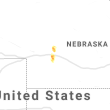
Nebraska
| Local Time | Report Details |
|---|---|
| 7:54 PM CDT | Quarter sized hail reported near Hershey, NE, 11.4 miles W of North Platte, NE, quarter size hail |
| 8:00 PM CDT | Golf Ball sized hail reported near North Platte, NE, 7.7 miles SW of North Platte, NE, 3 miles west lake maloney golf ball hail |
| 8:02 PM CDT | Golf Ball sized hail reported near Sutherland, NE, 18.5 miles WSW of North Platte, NE, quarter to golf ball sized hail. |
| 8:02 PM CDT | Golf Ball sized hail reported near North Platte, NE, 7.7 miles WSW of North Platte, NE, quarter to golf ball sized hail. |
| 8:05 PM CDT | Tennis Ball sized hail reported near North Platte, NE, 7.7 miles SW of North Platte, NE, 2.5 inch hail |
Connect with Interactive Hail Maps