

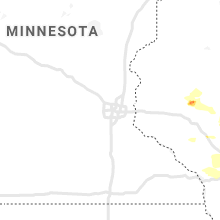
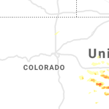
Hail Map for Thursday, June 24, 2021

Number of Impacted Households on 6/24/2021
0
Impacted by 1" or Larger Hail
0
Impacted by 1.75" or Larger Hail
0
Impacted by 2.5" or Larger Hail
Square Miles of Populated Area Impacted on 6/24/2021
0
Impacted by 1" or Larger Hail
0
Impacted by 1.75" or Larger Hail
0
Impacted by 2.5" or Larger Hail


Cities Most Affected by Hail Storms of 6/24/2021
| Hail Size | Demographics of Zip Codes Affected | ||||||
|---|---|---|---|---|---|---|---|
| City | Count | Average | Largest | Pop Density | House Value | Income | Age |
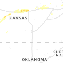
| Syracuse, KS | 3 | 2.08 | 2.50 | 0 | $62k | $31.6k | 32.3 |
| Sheridan Lake, CO | 1 | 4.00 | 4.00 | 1 | $25k | $30.7k | 38.8 |
| Stevens Point, WI | 2 | 1.75 | 1.75 | 415 | $94k | $39.7k | 27.9 |
| Bloomer, WI | 1 | 2.00 | 2.00 | 45 | $86k | $40.7k | 40.2 |
| Holly, CO | 1 | 2.00 | 2.00 | 1 | $42k | $27.2k | 43.2 |
| Doniphan, NE | 1 | 1.75 | 1.75 | 13 | $94k | $45.4k | 41.9 |
| Kit Carson, CO | 1 | 1.75 | 1.75 | 0 | $45k | $28.1k | 42.2 |
| Trumbull, NE | 1 | 1.75 | 1.75 | 9 | $72k | $41.6k | 40.0 |
| Coolidge, KS | 1 | 1.75 | 1.75 | 0 | $52k | $40.3k | 42.9 |
Hail and Wind Damage Spotted on 6/24/2021
Filter by Report Type:Hail ReportsWind Reports
States Impacted
Wisconsin, Florida, Nevada, Colorado, Nebraska, Montana, New Mexico, Kansas, Alabama, Iowa, Missouri, Wyoming, Texas, OklahomaWisconsin
| Local Time | Report Details |
|---|---|
| 7:30 AM CDT | Quarter sized hail reported near Stevens Point, WI, 76.6 miles W of Green Bay, WI, mostly nickel size... but some quarters. |
| 3:30 PM CDT | Large... healthy tree snapped... photo on social medi in chippewa county WI, 91.6 miles E of Minneapolis, MN |
| 3:34 PM CDT | Quarter sized hail reported near Bloomer, WI, 86.1 miles E of Minneapolis, MN, spotted reported near 64 and 53 interchange. |
| 3:40 PM CDT | Hen Egg sized hail reported near Bloomer, WI, 86.4 miles E of Minneapolis, MN, 2 inch hail... photo sent over social media. |
| 3:46 PM CDT | Ping Pong Ball sized hail reported near Colfax, WI, 79.6 miles E of Minneapolis, MN, spotter called in 1.5 inch hail with strong winds... only small branches down. |
| 6:10 PM CDT | Quarter sized hail reported near Vesper, WI, 77.1 miles NE of La Crosse, WI, wind gusts estimated of 60-65 mph |
| 6:15 PM CDT | Trees down. time estimate in wood county WI, 80.9 miles SSW of Rhinelander, WI |
| 6:30 PM CDT | Golf Ball sized hail reported near Stevens Point, WI, 77.1 miles W of Green Bay, WI, report from mping: golf ball (1.75 in.). |
| 6:31 PM CDT | Golf Ball sized hail reported near Stevens Point, WI, 76.6 miles W of Green Bay, WI |
| 6:42 PM CDT | Half Dollar sized hail reported near Plover, WI, 75.3 miles W of Green Bay, WI, also measured 32 mph winds. |
Florida
| Local Time | Report Details |
|---|---|
| 3:03 PM EDT | Asos station kfmy fort myer in lee county FL, 30.7 miles N of Naples, FL |
| 5:04 PM EDT | Broadcast media shared images on social media of tree damage in n sarasota. large oak tree branches snapped. older... possibly rotting tree snapped at base. time estima in sarasota county FL, 9.6 miles SSE of Bradenton, FL |
Nevada
| Local Time | Report Details |
|---|---|
| 1:30 PM PDT | Storm damage reported in nye county NV, 87.6 miles WNW of Las Vegas, NV |
| 6:27 PM PDT | Mesonet station pann2 pancake raws... elevation 5165 fee in nye county NV, 95.7 miles SW of Ely, NV |
Colorado
| Local Time | Report Details |
|---|---|
| 2:50 PM MDT | Storm damage reported in el paso county CO, 43 miles N of Pueblo, CO |
| 4:30 PM MDT | Grapefruit sized hail reported near Sheridan Lake, CO, 84.5 miles WNW of Garden City, KS |
| 4:42 PM MDT | Hen Egg sized hail reported near Holly, CO, 69.8 miles WNW of Garden City, KS |
| 5:20 PM MDT | Quarter sized hail reported near Arapahoe, CO, 77.3 miles SW of Colby, KS, delayed report. trained spotter reported sporadic quarter sized hail. |
| 7:00 PM MDT | Golf Ball sized hail reported near Kit Carson, CO, 83.5 miles S of Yuma, CO, delayed report of hail up to golf ball in size. |
| 7:00 PM MDT | Social media report of wind gusts to 80mph... 1.5 inches of rain... and hail just below quarter in size. time estimated by person reportin in kit carson county CO, 68.4 miles WSW of Colby, KS |
| 7:00 PM MDT | Spotter estimated 55-60 mph winds briefly along with pea sized hai in cheyenne county CO, 93.1 miles S of Yuma, CO |
| 7:02 PM MDT | Quarter sized hail reported near Eads, CO, 96.6 miles ENE of Pueblo, CO |
| 7:50 PM MDT | Rv was blown over by thunderstorm outflow according to a storm chaser. visibility was near zero due to blowing dus in kiowa county CO, 85.8 miles WNW of Garden City, KS |
| 7:58 PM MDT | Quarter sized hail reported near Sheridan Lake, CO, 93.9 miles SW of Colby, KS |
| 7:58 PM MDT | Storm damage reported in kiowa county CO, 93.9 miles SW of Colby, KS |
Nebraska
| Local Time | Report Details |
|---|---|
| 4:00 PM CDT | Quarter sized hail reported near Wood River, NE, 19 miles SSW of Grand Island, NE |
| 4:15 PM CDT | Golf Ball sized hail reported near Doniphan, NE, 15.6 miles S of Grand Island, NE, received photo via facebook of hail... estimated to be golf ball size. |
| 4:20 PM CDT | Ping Pong Ball sized hail reported near Trumbull, NE, 16.6 miles SSE of Grand Island, NE |
| 4:26 PM CDT | Relaying report of tree damage in tow in clay county NE, 17.3 miles SSE of Grand Island, NE |
| 4:27 PM CDT | Golf Ball sized hail reported near Trumbull, NE, 17.3 miles SSE of Grand Island, NE |
| 4:30 PM CDT | Ping Pong Ball sized hail reported near Hastings, NE, 16.9 miles S of Grand Island, NE, quarter to ping pong ball size hail reported... relayed by ksnb. |
| 5:00 PM CDT | Storm damage reported in clay county NE, 44.5 miles SSE of Grand Island, NE |
| 5:12 PM CDT | Emergency management reported 3 overturned pivots along road h near roads 5 and 6. time approximated from rada in fillmore county NE, 39.1 miles SE of Grand Island, NE |
| 5:40 PM CDT | County dispatch reported tree damage near road p and road 23. time approximated from rada in fillmore county NE, 57.7 miles ESE of Grand Island, NE |
| 5:43 PM CDT | County dispatch reported tree damage in the area... some tree limbs were down on highway 6 between roads 18 and 19. time approximated from rada in fillmore county NE, 48.7 miles ESE of Grand Island, NE |
| 6:50 PM CDT | Nebraska city trees uprooted on cars. trees with large branches broken. large amount of small debri in otoe county NE, 40.3 miles S of Omaha, NE |
| 7:45 PM CDT | Power lines and large trees down in nemaha roads blocke in nemaha county NE, 65 miles SSE of Omaha, NE |
Montana
| Local Time | Report Details |
|---|---|
| 3:05 PM MDT | Awos station kgdv glendive airpor in dawson county MT, 70.7 miles NE of Miles City, MT |
| 4:40 PM MDT | Half Dollar sized hail reported near Hobson, MT, 77.3 miles ESE of Great Falls, MT, 1 to 1.25 inch hail reported south of hobson near black bull rd. |
| 4:40 PM MDT | Strong wind gusts estimated around 60mph with sustained around 30 to 40 mp in judith basin county MT, 77.3 miles ESE of Great Falls, MT |
| 5:32 PM MDT | Very heavy rainfall with winds estimated to be about 60 mp in roosevelt county MT, 48.9 miles W of Williston, ND |
| 5:35 PM MDT | Awos station kmvh n bar ranch awos. time estimated based on rada in fergus county MT, 75 miles NNW of Billings, MT |
New Mexico
| Local Time | Report Details |
|---|---|
| 3:47 PM MDT | Kcqc aso in torrance county NM, 56.4 miles E of Albuquerque, NM |
| 5:05 PM MDT | Klvs aso in san miguel county NM, 57.2 miles SSE of Taos, NM |
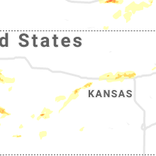
Kansas
| Local Time | Report Details |
|---|---|
| 6:03 PM CDT | Ping Pong Ball sized hail reported near Oketo, KS, 53.9 miles N of Manhattan, KS, delayed report. |
| 5:06 PM MDT | Golf Ball sized hail reported near Coolidge, KS, 62.8 miles WNW of Garden City, KS, golf ball size hail reported. |
| 5:26 PM MDT | Golf Ball sized hail reported near Syracuse, KS, 49.5 miles WNW of Garden City, KS, corrects previous hail report from 10 n syracuse. corrects previous hail report from 10 n syracuse. golf ball size hail reported. |
| 5:51 PM MDT | Hen Egg sized hail reported near Syracuse, KS, 48.9 miles W of Garden City, KS, egg size reported by storm chaser. |
| 5:54 PM MDT | Tennis Ball sized hail reported near Syracuse, KS, 42.6 miles W of Garden City, KS, tennis ball size hail reported. |
| 8:30 PM CDT | Storm damage reported in brown county KS, 65.3 miles NE of Manhattan, KS |
| 7:33 PM MDT | Quarter sized hail reported near Weskan, KS, 56.2 miles WSW of Colby, KS, caller reported nickel to quarter sized hail. |
| 7:59 PM MDT | Storm damage reported in wallace county KS, 62 miles SW of Colby, KS |
| 8:05 PM MDT | Ks mesone in wallace county KS, 58.8 miles SW of Colby, KS |
| 8:10 PM MDT | Half Dollar sized hail reported near Wallace, KS, 46 miles SW of Colby, KS, social media report of hail larger than quarter in size. currently ongoing. |
| 8:13 PM MDT | Storm damage reported in wallace county KS, 52.3 miles SW of Colby, KS |
| 8:23 PM MDT | Storm damage reported in wallace county KS, 55.1 miles SW of Colby, KS |
| 8:23 PM MDT | Report of winds gusting 55 to 65mp in wallace county KS, 58.6 miles SW of Colby, KS |
| 8:32 PM MDT | Storm damage reported in wallace county KS, 45.1 miles SW of Colby, KS |
| 8:34 PM MDT | Storm damage reported in wallace county KS, 45.3 miles SW of Colby, KS |
| 10:20 PM CDT | Kansas mesonet. time estimated by rada in logan county KS, 36.2 miles SSW of Colby, KS |
| 12:18 AM CDT | Estimated 60-65 mp in barton county KS, 21.8 miles SE of Hays, KS |
| 1:35 AM CDT | Awos station klyo lyons rice co. municipal airp in rice county KS, 66.9 miles NW of Wichita, KS |
| 3:40 AM CDT | Storm damage reported in shawnee county KS, 50.5 miles ESE of Manhattan, KS |
| 3:44 AM CDT | Storm damage reported in shawnee county KS, 50.5 miles ESE of Manhattan, KS |
| 3:54 AM CDT | Storm damage reported in shawnee county KS, 50.6 miles E of Manhattan, KS |
| 3:59 AM CDT | Report from mping: 1-inch tree limbs broken; shingles blown of in shawnee county KS, 52 miles E of Manhattan, KS |
Alabama
| Local Time | Report Details |
|---|---|
| 6:20 PM CDT | Quarter sized hail reported near Castleberry, AL, 47.6 miles SSE of Camden, AL, quarter size hail fell just northwest of castleberry at sandcut road near appleton road. |
Iowa
| Local Time | Report Details |
|---|---|
| 7:00 PM CDT | Reported at ottumwa industrial airpor in wapello county IA, 61.1 miles NW of Kahoka, MO |
| 7:05 PM CDT | Railcars blown over on i-29 and mile marker in fremont county IA, 47.6 miles SSE of Omaha, NE |
| 7:30 PM CDT | Tree blown on to hous in fremont county IA, 43.9 miles SSE of Omaha, NE |
Missouri
| Local Time | Report Details |
|---|---|
| 7:18 PM CDT | Quarter sized hail reported near Rock Port, MO, 52.5 miles SSE of Omaha, NE |
| 7:53 PM CDT | Storm damage reported in andrew county MO, 59.2 miles NNW of Kansas City, MO |
| 8:45 PM CDT | Storm damage reported in harrison county MO, 85.7 miles NNE of Kansas City, MO |
| 8:50 PM CDT | Power line and tree down just north of jameson near kodiak and highway 1 in daviess county MO, 70.1 miles NNE of Kansas City, MO |
| 8:50 PM CDT | 4 power poles down on highway 69 in daviess county MO, 68.2 miles NNE of Kansas City, MO |
| 9:00 PM CDT | Storm damage reported in grundy county MO, 80.7 miles NNE of Kansas City, MO |
| 9:15 PM CDT | Storm damage reported in buchanan county MO, 48.2 miles NNW of Kansas City, MO |
| 9:15 PM CDT | Numerous trees and power lines down across trento in grundy county MO, 84.8 miles NE of Kansas City, MO |
| 9:20 PM CDT | Route v closed with trees and power lines down over the roa in grundy county MO, 90.6 miles NE of Kansas City, MO |
| 9:30 PM CDT | Possible tornado. 30 foot section of new barn roof ripped off. whole trees down. 2x4s driven into groun in grundy county MO, 89.3 miles WSW of Kahoka, MO |
| 11:14 PM CDT | Storm spotter estimated 60 mph wind in randolph county MO, 27.1 miles N of Columbia, MO |
| 12:03 AM CDT | Ham reported 50-60 mph wind in audrain county MO, 32.8 miles NE of Columbia, MO |
| 12:08 AM CDT | Driver reporting tree debris all over highway at highway 36 near highway in marion county MO, 51.3 miles S of Kahoka, MO |
| 12:11 AM CDT | 60 to 70 mph wind gusts in town. no damage so fa in marion county MO, 52.6 miles SSE of Kahoka, MO |
| 12:12 AM CDT | Large locust tree fell onto a house. walls are buckling under the weight of the tree and breaking windows. on highway o at silvers lan in ralls county MO, 53.7 miles SSE of Kahoka, MO |
Wyoming
| Local Time | Report Details |
|---|---|
| 6:56 PM MDT | Storm damage reported in niobrara county WY, 61.3 miles NNW of Scottsbluff, NE |
Texas
| Local Time | Report Details |
|---|---|
| 8:26 PM CDT | Report of multiple power poles dow in loving county TX, 72.1 miles W of Odessa, TX |
| 8:40 PM CDT | Report of multiple power poles dow in loving county TX, 72.1 miles W of Odessa, TX |
| 8:42 PM CDT | Palo duro resservoi in hansford county TX, 87.6 miles NNE of Amarillo, TX |
| 9:15 PM CDT | Sheriff called and reported that a barn had been destroyed about 4 miles north of perryton... there were powerlines that had been snapped... and trees down. time is est in ochiltree county TX, 78.1 miles W of Woodward, OK |
| 9:28 PM CDT | West texas mesonet umbarger 3nne measured 58 mph wind gus in randall county TX, 20.5 miles SW of Amarillo, TX |
Oklahoma
| Local Time | Report Details |
|---|---|
| 9:18 PM CDT | Semi blown over on u.s. highway 83 by thunderstorm wind gus in beaver county OK, 78.8 miles W of Woodward, OK |
| 9:18 PM CDT | Corrects previous tstm wnd dmg report from 3 sse gray. ochiltree sherriff reported that trees were blown down at the state lin in beaver county OK, 78.8 miles W of Woodward, OK |
| 9:24 PM CDT | One power pole blown down by thunderstorm wind gus in beaver county OK, 71.9 miles W of Woodward, OK |
| 9:50 PM CDT | Semi truck blown off road and 5 power poles downed. time estimated from rada in beaver county OK, 58.3 miles WNW of Woodward, OK |
Connect with Interactive Hail Maps