

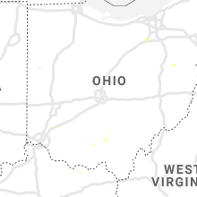
Hail Map for Friday, June 28, 2019

Number of Impacted Households on 6/28/2019
0
Impacted by 1" or Larger Hail
0
Impacted by 1.75" or Larger Hail
0
Impacted by 2.5" or Larger Hail
Square Miles of Populated Area Impacted on 6/28/2019
0
Impacted by 1" or Larger Hail
0
Impacted by 1.75" or Larger Hail
0
Impacted by 2.5" or Larger Hail
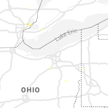


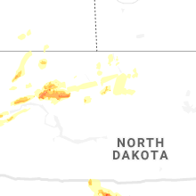


Cities Most Affected by Hail Storms of 6/28/2019
| Hail Size | Demographics of Zip Codes Affected | ||||||
|---|---|---|---|---|---|---|---|
| City | Count | Average | Largest | Pop Density | House Value | Income | Age |
| Homer Glen, IL | 1 | 1.75 | 1.75 | 910 | $0k | $0.0k | 42.8 |
| Saint Anthony, ND | 1 | 1.75 | 1.75 | 2 | $45k | $35.7k | 39.5 |
| Lemont, IL | 1 | 1.75 | 1.75 | 757 | $241k | $76.9k | 43.3 |
Hail and Wind Damage Spotted on 6/28/2019
Filter by Report Type:Hail ReportsWind Reports
States Impacted
Iowa, North Dakota, South Dakota, Missouri, Virginia, Illinois, Mississippi, Florida, Maryland, Tennessee, Alabama, Louisiana, Maine, Pennsylvania, Michigan, Arkansas, Kentucky, Ohio, Delaware, Texas, New Jersey, Montana, ColoradoIowa
| Local Time | Report Details |
|---|---|
| 7:25 AM CDT | Barn... silo... and power lines damaged at 2526 51st street drive about 3 miles south of brandon... ia. time estimate in benton county IA, 26.8 miles NW of Cedar Rapids, IA |
| 7:25 AM CDT | Barn destroyed at highway 218 and 52nd street. road had to be closed to clear some debris off of highway. time estimate in benton county IA, 33.8 miles NW of Cedar Rapids, IA |
| 7:58 AM CDT | Quarter sized hail reported near Dike, IA, 52.4 miles SSE of Mason City, IA, mping report. |
| 9:22 AM CDT | Quarter sized hail reported near Gilman, IA, 47.1 miles ENE of Des Moines, IA, social media picture. |
| 9:29 AM CDT | Quarter sized hail reported near Gilman, IA, 46.1 miles ENE of Des Moines, IA, mping report. |
| 10:30 AM CDT | Report from kniakrls radio via social media. large tree snapped in town. delayed report... time estimate in marion county IA, 33 miles SE of Des Moines, IA |
| 10:36 AM CDT | Trees down. time estimated from rada in keokuk county IA, 57.2 miles NNW of Kahoka, MO |
| 10:40 AM CDT | Tree down across 320th street. time estimated from rada in keokuk county IA, 55.5 miles NNW of Kahoka, MO |
| 10:40 AM CDT | Report from mping. large tree 2 to 3 foot diameter snapped in the city central squar in marion county IA, 38.2 miles ESE of Des Moines, IA |
| 10:42 AM CDT | Delayed report. numerous trees and branches down in city of packwood. time estimated based on rada in jefferson county IA, 52.5 miles NNW of Kahoka, MO |
| 10:45 AM CDT | Trees down. time estimated from rada in keokuk county IA, 55.1 miles NNW of Kahoka, MO |
| 10:50 AM CDT | Corn flattened. time estimated from rada in washington county IA, 53.9 miles SSW of Cedar Rapids, IA |
| 10:51 AM CDT | Several trees down across the city of eddyville. utility pole snapped. two houses had trees that fell on top of them. unknown damage to houses. delayed report and time in wapello county IA, 59.2 miles ESE of Des Moines, IA |
| 10:52 AM CDT | Report at the otm airport asos. sustained wind of 41 mp in wapello county IA, 61.1 miles NW of Kahoka, MO |
| 11:05 AM CDT | Appanoose county dispatch is reporting trees down and building damage in moravi in appanoose county IA, 63.6 miles SE of Des Moines, IA |
| 11:06 AM CDT | Roof damage to buildings. siding damage to buildings. multiple maple trees with limbs 10 to 12 inches in diameter down. winds went through center of town... tree damage in appanoose county IA, 63.6 miles SE of Des Moines, IA |
| 11:10 AM CDT | Trees and power lines down on railroad stree in washington county IA, 52 miles N of Kahoka, MO |
| 11:13 AM CDT | Social media report of trees down in albi in monroe county IA, 57.4 miles SE of Des Moines, IA |
| 11:20 AM CDT | Report of large branches down on the west side of ottumw in wapello county IA, 56.4 miles NW of Kahoka, MO |
| 11:30 AM CDT | Us army corps of engineers reports large branches down in campground near rathbun lak in appanoose county IA, 66.3 miles SE of Des Moines, IA |
| 11:50 AM CDT | Quarter sized hail reported near Bloomfield, IA, 43.3 miles WNW of Kahoka, MO, quarter sized hail and heavy rainfall. |
| 11:51 AM CDT | Gusty winds were bending small... weak trees completely over. bigger trees had 2 to 3 inch diameter branches broken off. small hail was occurring but appeared to be les in appanoose county IA, 53.9 miles WNW of Kahoka, MO |
| 11:55 AM CDT | Sheriffs office received call of trees down in mount pleasant. time estimate in henry county IA, 38.9 miles NNE of Kahoka, MO |
| 12:03 PM CDT | Spotter reports 6 to 8 inch tree limbs have been snapped. damage to a residential roof in tow in appanoose county IA, 53.9 miles WNW of Kahoka, MO |
| 12:52 PM CDT | Estimated winds 55 to 60 mph. possibly highe in des moines county IA, 38.4 miles NE of Kahoka, MO |
| 12:57 PM CDT | Storm damage reported in des moines county IA, 40.5 miles NE of Kahoka, MO |
North Dakota
| Local Time | Report Details |
|---|---|
| 8:08 AM CDT | Golf Ball sized hail reported near Saint Anthony, ND, 20.7 miles SSW of Bismarck, ND, numerous window were broken out of buildings and vehicles. |
| 9:20 AM CDT | Trained spotter reported wind gusts estimated up to 65 mph in strasburg... accompanied by torrential rainfall and small hail from pea to dime siz in emmons county ND, 54.6 miles SSE of Bismarck, ND |
| 9:25 AM CDT | Estimated 3 inch tree branches down. estimated 60 mph winds. 1.5 inches of rain. pea sized hai in emmons county ND, 54.6 miles SSE of Bismarck, ND |
| 5:57 AM CDT | Minot air force base asos had a gust to 58 mph at 5:57a in ward county ND, 13 miles NNW of Minot, ND |
South Dakota
| Local Time | Report Details |
|---|---|
| 11:16 AM CDT | Quarter sized hail reported near Eureka, SD, 63.6 miles WNW of Aberdeen, SD |
| 11:18 AM CDT | Quarter sized hail reported near Eureka, SD, 58.7 miles WNW of Aberdeen, SD |
Missouri
| Local Time | Report Details |
|---|---|
| 11:56 AM CDT | Telephone poles dow in schuyler county MO, 44.3 miles WNW of Kahoka, MO |
| 12:00 PM CDT | Trees and power lines down in unionvill in putnam county MO, 68.1 miles W of Kahoka, MO |
| 12:49 PM CDT | Tree branches snappe in adair county MO, 47.7 miles WSW of Kahoka, MO |
| 3:30 PM CDT | Relayed report of a 100+ year old tree 2-3 ft in diameter uprooted and blown over. hail was also reported to be a bit under golf ball siz in audrain county MO, 33.5 miles ENE of Columbia, MO |
| 4:41 PM CDT | Corrects previous tstm wnd dmg report from 2 ne saint charles. reported at 2545 w randolph st charles: tree branches from large tree down... also pea sized hai in st. charles county MO, 20.1 miles NW of Saint Louis, MO |
| 4:46 PM CDT | Corrects previous tstm wnd dmg report from 2 ne wildwood. reported at clayton rd and 109: power outages reported due to downed line in st. louis county MO, 23.9 miles W of Saint Louis, MO |
| 5:09 PM CDT | Reported at 2545 w randolph st charles: tree branches from large tree down... also pea sized hai in st. charles county MO, 20.1 miles NW of Saint Louis, MO |
Virginia
| Local Time | Report Details |
|---|---|
| 1:36 PM EDT | 2 trees downed on grassy hill rd north of rocky mountl... with 1.30 inches of rain in 20 minutes. time estimated from rada in franklin county VA, 13.2 miles S of Roanoke, VA |
| 3:22 PM EDT | Three trees blown down. a large kennel was blown 14 feet. time estimated by rada in pittsylvania county VA, 40.9 miles SSE of Roanoke, VA |
| 3:30 PM EDT | Trees down on burkeville r in lunenburg county VA, 42.5 miles SW of Richmond, VA |
| 3:45 PM EDT | Trees dow in lunenburg county VA, 45.6 miles SW of Richmond, VA |
| 4:12 PM EDT | Numerous tree limbs downed at the south boston speedway... and several pop-up tents and awnings for an outdoor event were damaged. no injuries. time estimated from rada in halifax county VA, 65 miles N of Raleigh, NC |
| 4:55 PM EDT | Dozens of trees down in nelson count in nelson county VA, 71.1 miles WNW of Richmond, VA |
| 5:05 PM EDT | Trees down on old robert's roa in nelson county VA, 68.1 miles WNW of Richmond, VA |
| 5:10 PM EDT | Numerous limbs... branches and a tree down along us 11 between va 714 and 717. tree is blocking va 716. time based on rada in rockbridge county VA, 50.5 miles NE of Roanoke, VA |
| 5:26 PM EDT | Corrects previous tstm wnd dmg report from 2 w halifax. approximately a dozen trees down all around the town of halifax. one tree caused cosmetic damage to a truck... a in halifax county VA, 63.8 miles ESE of Roanoke, VA |
| 5:30 PM EDT | Multiple large trees down in 100 block of downing circl in frederick county VA, 87.1 miles W of Baltimore, MD |
| 5:30 PM EDT | Stop sign blown over and trees down in the stephens city are in frederick county VA, 87.4 miles W of Baltimore, MD |
| 5:37 PM EDT | Trees down along harmon plac in frederick county VA, 87.1 miles W of Baltimore, MD |
| 5:44 PM EDT | Trees down in the area of remount road near slate hill driv in warren county VA, 88.8 miles WSW of Baltimore, MD |
| 5:45 PM EDT | Tree blocking roadway in scottsville are in albemarle county VA, 50.3 miles WNW of Richmond, VA |
| 6:05 PM EDT | Dozens of trees down in nelson count in nelson county VA, 71.1 miles WNW of Richmond, VA |
| 6:10 PM EDT | Trees down along f.t. valley roa in rappahannock county VA, 82.8 miles NNW of Richmond, VA |
| 6:15 PM EDT | Trees down along richmond roa in rappahannock county VA, 83.1 miles NNW of Richmond, VA |
| 6:40 PM EDT | Trees down in the slate mills are in rappahannock county VA, 76.4 miles NNW of Richmond, VA |
| 6:41 PM EDT | Tree down in the 10600 block of hume roa in fauquier county VA, 79.3 miles WSW of Baltimore, MD |
| 6:55 PM EDT | Trees and wires down along garth run roa in madison county VA, 71.2 miles NNW of Richmond, VA |
Illinois
| Local Time | Report Details |
|---|---|
| 12:53 PM CDT | Large tree down. time estimated by rada in henderson county IL, 40.6 miles ENE of Kahoka, MO |
| 12:53 PM CDT | Large tree down. time estimated from rada in henderson county IL, 38.1 miles ENE of Kahoka, MO |
| 12:54 PM CDT | Portion of a garage roof blown off and shed window blown ou in henderson county IL, 40.9 miles ENE of Kahoka, MO |
| 3:09 PM CDT | Power lines reported down in tow in morgan county IL, 74.6 miles SSW of Peoria, IL |
| 6:04 PM CDT | Quarter sized hail reported near Homer Glen, IL, 25.4 miles SW of Chicago, IL, report received via social media. |
| 6:09 PM CDT | Golf Ball sized hail reported near Homer Glen, IL, 23.3 miles SW of Chicago, IL |
| 6:12 PM CDT | Quarter sized hail reported near Lemont, IL, 23.7 miles SW of Chicago, IL, reported at 14600 127th st... lemont... il 60439. |
| 6:13 PM CDT | Golf Ball sized hail reported near Lemont, IL, 24.2 miles SW of Chicago, IL |
| 6:14 PM CDT | Quarter sized hail reported near Homer Glen, IL, 26.7 miles SW of Chicago, IL |
| 6:50 PM CDT | Half Dollar sized hail reported near Chicago, IL, 4.6 miles N of Chicago, IL, report received via social media. |
| 6:50 PM CDT | Half Dollar sized hail reported near Chicago, IL, 4 miles NNW of Chicago, IL, report received via social media. |
Mississippi
| Local Time | Report Details |
|---|---|
| 1:24 PM CDT | Multiple trees and power lines down on daneville roa in copiah county MS, 31.6 miles SW of Jackson, MS |
| 1:24 PM CDT | Reports of trees down on highway 1 in copiah county MS, 36.3 miles SW of Jackson, MS |
| 1:57 PM CDT | Multiple trees and power lines down on highway 28. there are also reports of trees blocking part of highway 2 in copiah county MS, 41.5 miles SSW of Jackson, MS |
Florida
| Local Time | Report Details |
|---|---|
| 1:35 PM CDT | Cable line down in the laguna beach are in bay county FL, 25.8 miles ESE of Miramar Beach, FL |
| 4:00 PM EDT | A wind gust of 52 kts... or 60 mph... was recorded by the c-man station at long key ligh in gmz032 county FL, 62.3 miles ENE of Key West, FL |
| 5:22 PM EDT | Quarter sized hail reported near Saint Petersburg, FL, 22.1 miles NNW of Bradenton, FL, skywarn spotter reported 1 inch diameter hail. |
| 6:15 PM EDT | L006 reported a wind gust of 55 knots with a severe thunderstorm moving through southern waters of lake okeechbe in amz610 county FL, 40.5 miles SW of Port Saint Lucie, FL |
| 6:54 PM EDT | Trees down on houses in yankeetown... f in levy county FL, 86.8 miles WNW of Orlando, FL |
Maryland
| Local Time | Report Details |
|---|---|
| 2:45 PM EDT | Large trees down. damage to a trailer... chicken house and trampoline. 7300 block of parsonsburg rd... grant r in wicomico county MD, 21.3 miles W of Ocean City, MD |
| 3:45 PM EDT | Multiple trees down in the rosedale area... including one onto a hous in baltimore county MD, 5.5 miles ENE of Baltimore, MD |
| 5:38 PM EDT | Three large branches down in 5700 block of falkland plac in prince georges county MD, 32.6 miles SSW of Baltimore, MD |
| 5:40 PM EDT | Numerous trees down blocking roads... on wires... with 3 onto house in prince georges county MD, 34.7 miles SSW of Baltimore, MD |
Tennessee
| Local Time | Report Details |
|---|---|
| 2:50 PM EDT | Trees down along north rogers r in sevier county TN, 11.9 miles ESE of Knoxville, TN |
| 2:50 PM EDT | Trees down along sugar loaf r in sevier county TN, 17.3 miles ESE of Knoxville, TN |
| 3:30 PM EDT | Several trees down along highway 35/70 near newpor in cocke county TN, 41.5 miles E of Knoxville, TN |
| 3:48 PM EDT | Trees down in the hardin valley are in knox county TN, 13.4 miles W of Knoxville, TN |
| 4:00 PM EDT | Tree and power lines down in karns along oak ridge hwy. time estimated by rada in knox county TN, 10.1 miles W of Knoxville, TN |
| 4:00 PM EDT | Trees down on lonas d in knox county TN, 3.9 miles W of Knoxville, TN |
| 4:06 PM EDT | Several trees down along hickory creek road in west knox count in knox county TN, 17.7 miles WSW of Knoxville, TN |
| 4:25 PM EDT | Several trees down on white wing r in loudon county TN, 22.9 miles WSW of Knoxville, TN |
| 4:47 PM EDT | 20 reports of trees down east of kingsto in roane county TN, 27.6 miles WSW of Knoxville, TN |
| 4:58 PM EDT | Trees and power lines down across the count in loudon county TN, 31.4 miles WSW of Knoxville, TN |
| 5:00 PM EDT | Trees down... bent garage doors... and power outages near lenoir cit in loudon county TN, 24 miles WSW of Knoxville, TN |
Alabama
| Local Time | Report Details |
|---|---|
| 2:34 PM CDT | Two single tree down reports... one at gallant rd and dogwood drive and the other at highway 431 and highway 205 near mountainboro. winds estimated 30-40 mph per rada in etowah county AL, 44.9 miles NE of Birmingham, AL |
| 2:53 PM CDT | Tree reported on house in muscle shoals. time estimated by rada in colbert county AL, 3.8 miles SSE of Florence, AL |
| 2:53 PM CDT | Tree reported blown down on vehicle. winds estimated at 40 to 50 mph via a user video. time estimated by rada in colbert county AL, 3.5 miles S of Florence, AL |
| 4:04 PM CDT | 1 report of an oak tree downed... clipping a house. 1 report of large branches downed. both in the woodstock area. time estimated from rada in bibb county AL, 29.5 miles SW of Birmingham, AL |
| 4:50 PM CDT | Asos station kmob measured wind gusts of 59mph with sustained wind of 48mp in mobile county AL, 11.7 miles W of Mobile, AL |
| 4:50 PM CDT | Metal roof lifted off a building near schillinger & old shell rd. several reports of trees down. reports and pictures via social medi in mobile county AL, 10.5 miles W of Mobile, AL |
| 6:00 PM CDT | Trees reported down in the town of toney along toney school road. time estimated by rada in madison county AL, 52.5 miles E of Florence, AL |
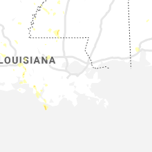
Louisiana
| Local Time | Report Details |
|---|---|
| 2:48 PM CDT | C-man station einl1 measured a gust of 53 knot in st. mary county LA, 70 miles SSE of Lafayette, LA |
| 3:40 PM CDT | One inch diamater tree limbs were blown dow in livingston county LA, 64 miles NW of New Orleans, LA |
| 4:15 PM CDT | Tree down on old hammond highway in baton roug in east baton rouge county LA, 56.5 miles ENE of Lafayette, LA |
| 4:15 PM CDT | Tree down off hwy 1032 near garrison lan in livingston county LA, 64.1 miles NW of New Orleans, LA |
| 5:06 PM CDT | Tree and power line down on hwy 146 near woods roa in lincoln county LA, 45.3 miles WSW of Bastrop, LA |
| 6:13 PM CDT | Quarter sized hail reported near Church Point, LA, 11.7 miles WNW of Lafayette, LA, nickel and quarter sized hail reported by trained spotter. |
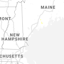
Maine
| Local Time | Report Details |
|---|---|
| 4:06 PM EDT | Trees and wires down in south jefferson with nickel sized hai in lincoln county ME, 48.6 miles NE of Portland, ME |
Pennsylvania
| Local Time | Report Details |
|---|---|
| 4:14 PM EDT | Tree and wires down in martic townshi in lancaster county PA, 39.9 miles NNE of Baltimore, MD |
| 4:44 PM EDT | Large tree split in two near the base. time estimated from rada in lehigh county PA, 49.1 miles S of Scranton, PA |
| 5:17 PM EDT | 50 kt gust reported at kab in lehigh county PA, 53.6 miles SSE of Scranton, PA |
| 5:19 PM EDT | Several reports of trees down. time estimated from rada in lehigh county PA, 54.7 miles S of Scranton, PA |
| 5:29 PM EDT | Mping report of tree limbs down and shingles blown off at this location. time estimated from rada in lehigh county PA, 60.2 miles SSE of Scranton, PA |
| 5:33 PM EDT | Tree down onto wires with a transformer fire. time estimated from rada in northampton county PA, 53.1 miles SSE of Scranton, PA |
| 5:33 PM EDT | Report of power lines down near the intersection of old bethlehem pike and saucon drive. time estimated from rada in lehigh county PA, 60.3 miles SSE of Scranton, PA |
| 5:42 PM EDT | Quarter sized hail reported near Oley, PA, 74.7 miles S of Scranton, PA, at intersection of covered bridge road and memorial highway in oley twp. |
| 5:45 PM EDT | Few tree limbs down with wind gusts estimated 50 to 60 mph. time estimated from rada in northampton county PA, 59.7 miles SSE of Scranton, PA |
| 5:49 PM EDT | Downed tree at intersection of douglass drive and pine forge road. time estimated from rada in berks county PA, 78 miles S of Scranton, PA |
| 5:52 PM EDT | Corrects time of previous tstm wnd dmg report from 4 sse oley. tree down at the intersection of blacksmith rd and hunter rd. time estimated from rada in berks county PA, 74.1 miles S of Scranton, PA |
| 6:52 PM EDT | Tree down at the intersection of blacksmith rd and hunter rd. time estimated from rada in berks county PA, 74.1 miles S of Scranton, PA |
| 6:52 PM EDT | Tree and wires blocking the entire road on west third avenue near chestnut street. time estimated from rada in montgomery county PA, 84.4 miles WSW of Brooklyn, NY |
| 6:55 PM EDT | Gusts estimated 65 to 70mph with pea size hai in montgomery county PA, 84.8 miles S of Scranton, PA |
| 6:55 PM EDT | Numerous trees down south of evansburg. time estimated from rada in montgomery county PA, 82 miles WSW of Brooklyn, NY |
| 6:56 PM EDT | Downed tree blocking germantown pike both directions between grange ave and rdg pike. time estimated from rada in montgomery county PA, 84.5 miles WSW of Brooklyn, NY |
| 7:19 PM EDT | Social media video of two trees blown down during storm on south broad street. time estimated from rada in philadelphia county PA, 82.4 miles SW of Brooklyn, NY |
| 7:36 PM EDT | Trees and power lines down in lawrence county PA, 42.3 miles NNW of Pittsburgh, PA |
| 8:28 PM EDT | Trees down in allegheny county PA, 2.3 miles WSW of Pittsburgh, PA |
| 8:35 PM EDT | Power lines down at rt 136 and wooster st in westmoreland county PA, 20.4 miles SE of Pittsburgh, PA |
| 2:15 AM EDT | Crawford county dispatch reports tree down at pymatuning state park near oh/pa state lin in crawford county PA, 64.3 miles E of Cleveland, OH |
Michigan
| Local Time | Report Details |
|---|---|
| 4:34 PM EDT | Quarter sized hail reported near Saint Clair Shores, MI, 54.1 miles SE of Flint, MI, spotter sent pictures of quarter-sized hail. |
| 4:40 PM EDT | Quarter sized hail reported near Saint Clair Shores, MI, 54.1 miles SE of Flint, MI, social media pictures of quarter-sized hail. |
| 7:34 PM EDT | Power lines down at brown city road and church roa in lapeer county MI, 33.3 miles E of Flint, MI |
Arkansas
| Local Time | Report Details |
|---|---|
| 3:42 PM CDT | Trees down on oakland road in stron in union county AR, 34.5 miles NW of Bastrop, LA |
| 10:10 PM CDT | Quarter sized hail reported near Camden, AR, 67.5 miles ESE of Nashville, AR |
Kentucky
| Local Time | Report Details |
|---|---|
| 4:53 PM EDT | A couple of trees were downed near intersection of ky 28 and spencer fork road. public report via social media. the time of the event is radar estimate in perry county KY, 42.4 miles SE of Irvine, KY |
| 4:55 PM EDT | 5 trees were reported to have been blown down on buckeye branch road. the event time is radar estimate in knox county KY, 55.4 miles SSE of Irvine, KY |
| 7:06 PM EDT | Tree down ne of georgetown... k in scott county KY, 48.7 miles NW of Irvine, KY |
| 7:15 PM EDT | Tree down in cynthiana... k in harrison county KY, 50.7 miles SSE of Cincinnati, OH |
Ohio
| Local Time | Report Details |
|---|---|
| 5:30 PM EDT | Trees and power lines dow in portage county OH, 29.5 miles SE of Cleveland, OH |
| 7:14 PM EDT | Roof partially torn off old barn. photo verified. time estimated from rada in adams county OH, 46.2 miles ESE of Cincinnati, OH |
| 7:30 PM EDT | Thunderstorm wind gust 68 mph/59 knot in cuyahoga county OH, 1.1 miles N of Cleveland, OH |
| 7:37 PM EDT | Several trees down through the city and power outage in medina county OH, 26.6 miles SSW of Cleveland, OH |
| 7:58 PM EDT | Trees and power line downe in wayne county OH, 39.9 miles SSW of Cleveland, OH |
| 8:03 PM EDT | Quarter sized hail reported near Wadsworth, OH, 30.7 miles S of Cleveland, OH |
Delaware
| Local Time | Report Details |
|---|---|
| 6:05 PM EDT | Quarter sized hail reported near Newark, DE, 53.9 miles ENE of Baltimore, MD, time estimated from radar. |
Texas
| Local Time | Report Details |
|---|---|
| 5:10 PM CDT | Quarter sized hail reported near Houston, TX, 16.8 miles NNW of Houston, TX, image of approximately one inch size hail reported via social media at veterans and bammel. |
| 8:47 PM CDT | Pictures on twitter of tree branches down in boerne. time estimated from rada in kendall county TX, 28.9 miles NNW of San Antonio, TX |
| 3:50 AM CDT | Quarter sized hail reported near Texarkana, TX, 39 miles SSW of Nashville, AR |
New Jersey
| Local Time | Report Details |
|---|---|
| 7:37 PM EDT | Tree down on 8th st at hunter dr. time estimated from rada in camden county NJ, 80.1 miles SW of Brooklyn, NY |
Montana
| Local Time | Report Details |
|---|---|
| 6:45 PM MDT | Quarter sized hail reported near Moore, MT, 83.6 miles ESE of Great Falls, MT, quarter sized hail reported by storm spotters driving through the storm on us 191. hail fell from 643 pm to 648 pm. |
| 6:58 PM MDT | Awos station k1em echo. time is estimate in fergus county MT, 77.1 miles S of Havre, MT |
| 6:59 PM MDT | Half Dollar sized hail reported near Moore, MT, 82.7 miles ESE of Great Falls, MT |
| 7:05 PM MDT | Also had pea size hail in phillips county MT, 68.2 miles SE of Havre, MT |
| 7:25 PM MDT | Half Dollar sized hail reported near Lewistown, MT, 94 miles NNW of Billings, MT |
| 7:45 PM MDT | Half Dollar sized hail reported near Zortman, MT, 74.9 miles SE of Havre, MT, hail fell between 730 and 755 pm. |
| 8:30 PM MDT | Half Dollar sized hail reported near Malta, MT, 62 miles WSW of Glasgow, MT, also had 45 mph wind and heavy rain |
| 9:00 PM MDT | Heavy rain in phillips county MT, 42.2 miles WSW of Glasgow, MT |
| 9:03 PM MDT | Saco dot in valley county MT, 35.6 miles WNW of Glasgow, MT |
| 9:10 PM MDT | Multiple 6 inch diameter limbs broken off trees. 3 inches of rain in half an hour in phillips county MT, 38.3 miles WNW of Glasgow, MT |
| 9:15 PM MDT | Estimated wind gusts between 55 and 60 mph between 9 and 91 in valley county MT, 26 miles WNW of Glasgow, MT |
| 9:30 PM MDT | Storm damage reported in valley county MT, 19.1 miles NW of Glasgow, MT |
| 10:09 PM MDT | Storm damage reported in valley county MT, 2.3 miles NW of Glasgow, MT |
| 10:10 PM MDT | Storm damage reported in valley county MT, 1.8 miles NNW of Glasgow, MT |
| 11:45 PM MDT | Quarter sized hail reported near Wolf Point, MT, 46.7 miles E of Glasgow, MT, reported received through social media. |
Colorado
| Local Time | Report Details |
|---|---|
| 8:55 PM MDT | Awos station klmo longmont vance bran in boulder county CO, 31.1 miles NNW of Denver, CO |
Connect with Interactive Hail Maps