

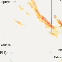
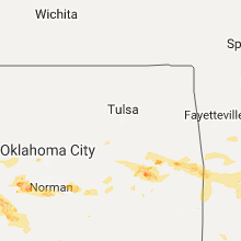
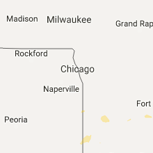
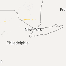
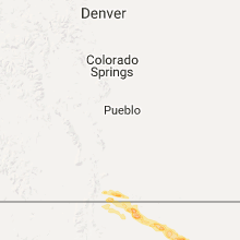
Hail Map for Friday, June 30, 2017

Number of Impacted Households on 6/30/2017
0
Impacted by 1" or Larger Hail
0
Impacted by 1.75" or Larger Hail
0
Impacted by 2.5" or Larger Hail
Square Miles of Populated Area Impacted on 6/30/2017
0
Impacted by 1" or Larger Hail
0
Impacted by 1.75" or Larger Hail
0
Impacted by 2.5" or Larger Hail


Cities Most Affected by Hail Storms of 6/30/2017
| Hail Size | Demographics of Zip Codes Affected | ||||||
|---|---|---|---|---|---|---|---|
| City | Count | Average | Largest | Pop Density | House Value | Income | Age |
| Lawton, OK | 3 | 2.83 | 3.00 | 116 | $65k | $30.7k | 34.8 |
| Childress, TX | 2 | 2.75 | 3.00 | 7 | $45k | $27.5k | 33.8 |
| Greenwood, AR | 2 | 1.88 | 2.00 | 150 | $79k | $37.5k | 36.8 |
| Fort Smith, AR | 2 | 1.88 | 2.00 | 676 | $97k | $41.0k | 40.1 |
| Chickasha, OK | 1 | 2.75 | 2.75 | 123 | $53k | $28.1k | 37.5 |
| Floyd, NM | 1 | 2.75 | 2.75 | 1 | $55k | $30.6k | 45.4 |
| Carnegie, OK | 1 | 2.00 | 2.00 | 8 | $42k | $24.6k | 41.2 |
| Gotebo, OK | 1 | 1.75 | 1.75 | 2 | $22k | $28.8k | 44.4 |
| Fort Sumner, NM | 1 | 1.75 | 1.75 | 0 | $46k | $25.9k | 47.6 |
| Anton, TX | 1 | 1.75 | 1.75 | 4 | $38k | $30.6k | 39.3 |
| Ballston Spa, NY | 1 | 1.75 | 1.75 | 427 | $111k | $49.8k | 39.7 |
| Littlefield, TX | 1 | 1.75 | 1.75 | 26 | $36k | $27.3k | 35.3 |
Hail and Wind Damage Spotted on 6/30/2017
Filter by Report Type:Hail ReportsWind Reports
States Impacted
Arkansas, New York, Indiana, Alabama, Ohio, Maine, Pennsylvania, Massachusetts, Mississippi, Vermont, Virginia, Michigan, Oklahoma, Connecticut, South Carolina, Florida, Minnesota, New Mexico, TexasArkansas
| Local Time | Report Details |
|---|---|
| 7:10 AM CDT | Thunderstorm winds damaged the roofs of a home and barn in marion county AR, 80.2 miles SSE of Springfield, MO |
| 8:36 PM CDT | Golf Ball sized hail reported near Fort Smith, AR, 5.1 miles SE of Fort Smith, AR |
| 8:44 PM CDT | Hen Egg sized hail reported near Fort Smith, AR, 8.5 miles SSE of Fort Smith, AR, near riley farm |
| 8:58 PM CDT | Golf Ball sized hail reported near Greenwood, AR, 14.6 miles SE of Fort Smith, AR |
| 8:59 PM CDT | Hen Egg sized hail reported near Greenwood, AR, 14.6 miles SE of Fort Smith, AR |
New York
| Local Time | Report Details |
|---|---|
| 1:45 PM EDT | Trees and wires down. also in preston... pharsalia... wille in chenango county NY, 44.5 miles SSE of Syracuse, NY |
| 2:39 PM EDT | Tree down blocking roadway in broome county NY, 53.2 miles N of Scranton, PA |
| 3:42 PM EDT | Tree limb down on east 11th avenu in fulton county NY, 26.5 miles NW of Schenectady, NY |
| 3:42 PM EDT | Trees and wires down at west bush road on route 122 in fulton county NY, 28.9 miles NW of Schenectady, NY |
| 3:54 PM EDT | Two trees and wires down on county road 10 in fulton county NY, 21.6 miles NW of Schenectady, NY |
| 4:00 PM EDT | Golf Ball sized hail reported near Ballston Spa, NY, 14.2 miles NNE of Schenectady, NY |
| 4:09 PM EDT | Route 81 closed between lo see rd and eagle nest rd due to downed wires in the town of greenville in greene county NY, 29.1 miles S of Schenectady, NY |
| 4:28 PM EDT | *** 4 inj *** fireworks display tent collapsed at the pilot truck stop on route 9 in schodack in rensselaer county NY, 25.6 miles SSE of Schenectady, NY |
| 4:32 PM EDT | Route 20 closed bewteen bliss school house rd and route 66 trees/wires down in the town of nassau. time estimated by rada in rensselaer county NY, 30.4 miles SE of Schenectady, NY |
| 4:40 PM EDT | Tree down blocking us highway 20 in columbia county NY, 37.1 miles SE of Schenectady, NY |
| 4:40 PM EDT | Tree and pwer lines down in rensselaer county NY, 33 miles SE of Schenectady, NY |
| 4:41 PM EDT | Trees down on top of downed wires at intersection of guymard turnpike and finchville turnpike in orange county NY, 56.9 miles NNW of Brooklyn, NY |
| 4:46 PM EDT | Tree down on power lines on winslow rd in columbia county NY, 33 miles SE of Schenectady, NY |
| 4:49 PM EDT | Tree down on county route 8a in columbia county NY, 59 miles SSE of Schenectady, NY |
| 4:50 PM EDT | Possible tornado. multiple trees and utility poles down. tree on house. roof damag in oneida county NY, 28 miles E of Syracuse, NY |
| 5:25 PM EDT | Route 32 closed due to tree down on vehicle south of 5 corners from detour ores mills road to jackson avenue to route 94 in orange county NY, 53.1 miles N of Brooklyn, NY |
| 5:28 PM EDT | Extensive damage to horse barn on graffenburg rd at intersection of mallory rd. time estimated by rada in herkimer county NY, 47.5 miles E of Syracuse, NY |
| 5:35 PM EDT | Numerous trees and wires down across town in orange county NY, 53.7 miles N of Brooklyn, NY |
| 5:38 PM EDT | Wires down and burning at 50 shore road in orange county NY, 51.6 miles N of Brooklyn, NY |
| 5:40 PM EDT | Tree and wires down with wires on fire on route 32 near admore street in orange county NY, 53.7 miles N of Brooklyn, NY |
| 5:40 PM EDT | Tree into house on south jacqueline stree in orange county NY, 52.4 miles N of Brooklyn, NY |
Indiana
| Local Time | Report Details |
|---|---|
| 2:28 PM EDT | Tree limb dow in huntington county IN, 24.5 miles WSW of Fort Wayne, IN |
Alabama
| Local Time | Report Details |
|---|---|
| 1:42 PM CDT | Power line reported down in samson in geneva county AL, 53.9 miles NNE of Miramar Beach, FL |
Ohio
| Local Time | Report Details |
|---|---|
| 3:05 PM EDT | Quarter sized hail reported near Weston, OH, 71.5 miles ENE of Fort Wayne, IN, quarter size hail falling at bowling green wind farm. |
| 7:08 PM EDT | Several trees and power poles dow in morrow county OH, 52.5 miles NNE of Columbus, OH |
Maine
| Local Time | Report Details |
|---|---|
| 3:48 PM EDT | Trees down on vehicle and buildin in cumberland county ME, 27.6 miles NNW of Portland, ME |
| 3:50 PM EDT | Trees and wires down on songo school road in cumberland county ME, 25.2 miles NW of Portland, ME |
| 4:10 PM EDT | Trees down at the intersection of campbell shore rd and lake av in cumberland county ME, 16.9 miles NNW of Portland, ME |
| 4:20 PM EDT | Trees and wire down on sand bar road in cumberland county ME, 15.5 miles NW of Portland, ME |
Pennsylvania
| Local Time | Report Details |
|---|---|
| 4:35 PM EDT | Trees down. trees on wires. tree on house covingto in lackawanna county PA, 8.3 miles SE of Scranton, PA |
| 7:27 PM EDT | Damage to several barns and other farm structures reported on crystal cave... schiery... sharidin and oakhaven roads and on short lane in berks county PA, 64 miles S of Scranton, PA |
| 7:30 PM EDT | Some tree branches blown on to vehicles... top half of a pole blown down... and fence damage to one residence. time estimated from rada in berks county PA, 62.1 miles S of Scranton, PA |
Massachusetts
| Local Time | Report Details |
|---|---|
| 4:51 PM EDT | Tree down blocking road at cherry and willo in berkshire county MA, 43.2 miles SE of Schenectady, NY |
| 4:52 PM EDT | Tree blocking road on north plain road near north plain far in berkshire county MA, 48.5 miles SE of Schenectady, NY |
| 4:57 PM EDT | Tree dow in berkshire county MA, 47.5 miles SE of Schenectady, NY |
| 5:14 PM EDT | Tree down blocking route in berkshire county MA, 48.5 miles ESE of Schenectady, NY |
| 5:24 PM EDT | Tree down on route 2 partially blocking the road near the savoy state fores in franklin county MA, 55.4 miles ESE of Schenectady, NY |
Mississippi
| Local Time | Report Details |
|---|---|
| 3:55 PM CDT | Tree down on oak bowery r in jones county MS, 64 miles SE of Jackson, MS |
| 4:10 PM CDT | Tree fell on a van traveling down hwy 29. no injurie in jones county MS, 71.5 miles SE of Jackson, MS |
| 4:15 PM CDT | Large pine tree fell across rose l in jones county MS, 72 miles SE of Jackson, MS |
| 4:28 PM CDT | Fallen tree partially blocking george boutwell roa in jones county MS, 81.6 miles SE of Jackson, MS |
Vermont
| Local Time | Report Details |
|---|---|
| 5:05 PM EDT | 2 trees downed on morgan rd in addison county VT, 38.7 miles S of Burlington, VT |
Virginia
| Local Time | Report Details |
|---|---|
| 5:12 PM EDT | Tree down near the intersection of route 29 and faber roa in albemarle county VA, 63.8 miles WNW of Richmond, VA |
| 5:17 PM EDT | Tree down near the intersection of greenfield road and ennis mountain roa in nelson county VA, 70.2 miles WNW of Richmond, VA |
| 5:47 PM EDT | Tree down on polo grounds road just east of route 2 in albemarle county VA, 60.4 miles NW of Richmond, VA |
| 5:51 PM EDT | Tree down on wires in the 700 block of reas ford roa in albemarle county VA, 64.3 miles NW of Richmond, VA |
| 6:06 PM EDT | Tree down in the 4400 block of constitution highwa in orange county VA, 58.1 miles NW of Richmond, VA |
| 6:12 PM EDT | Tree down blocking pine bluff road near gateway driv in greene county VA, 67.9 miles NW of Richmond, VA |
| 6:15 PM EDT | Tree down in the 1400 block of jacks shop roa in madison county VA, 64.8 miles NW of Richmond, VA |
| 6:17 PM EDT | Tree down blocking octonia road near ford avenu in greene county VA, 70.4 miles NW of Richmond, VA |
| 6:27 PM EDT | Tree down near the intersection of shelby road and wolftown-hood roa in madison county VA, 69.4 miles NNW of Richmond, VA |
| 6:32 PM EDT | Tree down in the 1100 block of old blue ridge turnpik in madison county VA, 74.9 miles NNW of Richmond, VA |
| 6:41 PM EDT | Wires down on cedar ridge road near crooked run lan in culpeper county VA, 65.2 miles NNW of Richmond, VA |
Michigan
| Local Time | Report Details |
|---|---|
| 5:15 PM EDT | Large tree branches down. via twitte in wayne county MI, 47.4 miles SSE of Flint, MI |
Oklahoma
| Local Time | Report Details |
|---|---|
| 4:30 PM CDT | Golf Ball sized hail reported near Gotebo, OK, 80.9 miles WSW of Oklahoma City, OK |
| 5:35 PM CDT | Hen Egg sized hail reported near Carnegie, OK, 66.3 miles N of Wichita Falls, TX |
| 6:01 PM CDT | Quarter sized hail reported near Blanchard, OK, 27.9 miles SSW of Oklahoma City, OK |
| 6:08 PM CDT | Baseball sized hail reported near Chickasha, OK, 37.5 miles SW of Oklahoma City, OK, relayed by kokh tv. |
| 6:14 PM CDT | Quarter sized hail reported near Apache, OK, 61.7 miles SW of Oklahoma City, OK |
| 6:18 PM CDT | Quarter sized hail reported near Macomb, OK, 36 miles SE of Oklahoma City, OK |
| 6:20 PM CDT | Tennis Ball sized hail reported near Lawton, OK, 60.1 miles N of Wichita Falls, TX, from kswo tv. |
| 6:20 PM CDT | Tea Cup sized hail reported near Lawton, OK, 60.1 miles N of Wichita Falls, TX, from kswo tv. |
| 6:33 PM CDT | Tea Cup sized hail reported near Lawton, OK, 60.1 miles N of Wichita Falls, TX, from kswo tv. |
| 6:52 PM CDT | Storm damage reported in comanche county OK, 47.9 miles N of Wichita Falls, TX |
| 6:57 PM CDT | From kswo t in comanche county OK, 47 miles N of Wichita Falls, TX |
| 7:05 PM CDT | Storm damage reported in comanche county OK, 48 miles NNE of Wichita Falls, TX |
| 7:05 PM CDT | Warner pd reports trees uprooted... numerous branches dow in muskogee county OK, 51 miles W of Fort Smith, AR |
| 7:15 PM CDT | Power pole downe in mcclain county OK, 40 miles SSE of Oklahoma City, OK |
| 7:16 PM CDT | Storm damage reported in cotton county OK, 33 miles NNE of Wichita Falls, TX |
| 7:26 PM CDT | Quarter sized hail reported near Altus, OK, 52.5 miles ENE of Childress, TX, at city high school. |
| 7:29 PM CDT | Quarter sized hail reported near Altus, OK, 52.5 miles ENE of Childress, TX |
| 7:29 PM CDT | Many power lines downe in cotton county OK, 36.7 miles NNE of Wichita Falls, TX |
| 7:31 PM CDT | Quarter sized hail reported near Sallisaw, OK, 21.4 miles WNW of Fort Smith, AR, observed near i-40 and hwy 59. |
| 7:55 PM CDT | Quarter sized hail reported near , , 63.8 miles W of Fort Smith, AR, dime to quarter hail west of longtown. corrected for location. |
| 7:55 PM CDT | Quarter sized hail reported near Eufaula, OK, 62.9 miles W of Fort Smith, AR, dime to quarter hail near longtown. |
| 7:59 PM CDT | Multiple power poles downe in cotton county OK, 36.5 miles NNE of Wichita Falls, TX |
| 8:00 PM CDT | Quarter sized hail reported near , , 63.3 miles W of Fort Smith, AR |
| 8:40 PM CDT | Large tree blown down onto travel trailer at the valley inn rv par in pittsburg county OK, 42.7 miles NNE of Atoka, OK |
| 9:28 PM CDT | Tree limbs 1 inch in diameter broken and shingles blown off roo in le flore county OK, 56.4 miles SW of Fort Smith, AR |
| 10:15 PM CDT | Storm damage reported in carter county OK, 50.3 miles W of Atoka, OK |
| 10:20 PM CDT | Power poles down. semi overturned on i35 mile marker 1 in love county OK, 65 miles WSW of Atoka, OK |
| 10:40 PM CDT | Storm damage reported in marshall county OK, 52.3 miles WSW of Atoka, OK |
| 10:50 PM CDT | Power lines down... sheet metal building destroyed. time estimated from rada in marshall county OK, 43.1 miles SW of Atoka, OK |
| 10:58 PM CDT | Storm damage reported in marshall county OK, 43.6 miles WSW of Atoka, OK |
| 11:15 PM CDT | Estimated 60-70 mph near johnson creek campgrounds. possible microburst. no damage found as of ye in bryan county OK, 36.7 miles SW of Atoka, OK |
Connecticut
| Local Time | Report Details |
|---|---|
| 5:30 PM EDT | Multiple reports of trees and wires down on east side of torrington in litchfield county CT, 82 miles SSE of Schenectady, NY |
| 5:35 PM EDT | Multiple reports of wires down in winstea in litchfield county CT, 75.4 miles SE of Schenectady, NY |
| 6:11 PM EDT | Bahre corner road ... 5 transformers along with trees and wires blown over down onto the groun in hartford county CT, 76.8 miles W of Providence, RI |
| 6:15 PM EDT | Tree down on car on notch road. trees down on wires on west mountain road at roswell. tree down on route 10 202 near bike pat in hartford county CT, 72.2 miles W of Providence, RI |
| 6:34 PM EDT | Tree down at 156 walnut hill road between weed road and old hawleyville road in fairfield county CT, 55.7 miles NNE of Brooklyn, NY |
| 6:35 PM EDT | Multiple reports of wires down in winstea in litchfield county CT, 75.4 miles SE of Schenectady, NY |
| 6:39 PM EDT | Numerous trees and power lines down in town in new haven county CT, 77.7 miles NE of Brooklyn, NY |
| 6:46 PM EDT | Downed tree and power lines blocking road at intersection of waterbury road and lakeview avenue in new haven county CT, 79.7 miles NE of Brooklyn, NY |
South Carolina
| Local Time | Report Details |
|---|---|
| 5:32 PM EDT | 2 trees down at north hills drive and martintown road wes in aiken county SC, 2.2 miles N of Augusta, GA |
Florida
| Local Time | Report Details |
|---|---|
| 6:50 PM EDT | Lines down at zonal geranium court in palm coast. fire rescue enrout in flagler county FL, 63.5 miles N of Orlando, FL |
| 7:34 PM EDT | Lines down at zonal geranium court in palm coast. fire rescue enrout in flagler county FL, 63.5 miles N of Orlando, FL |
Minnesota
| Local Time | Report Details |
|---|---|
| 6:25 PM CDT | Quarter sized hail reported near Milaca, MN, 57.1 miles NNW of Minneapolis, MN, photo of hail submitted via facebook. |
New Mexico
| Local Time | Report Details |
|---|---|
| 5:54 PM MDT | Quarter sized hail reported near Grenville, NM, 81 miles N of Tucumcari, NM |
| 5:55 PM MDT | Storm damage reported in union county NM, 78.5 miles NNE of Tucumcari, NM |
| 6:25 PM MDT | Storm damage reported in union county NM, 74.9 miles NNE of Tucumcari, NM |
| 8:30 PM MDT | Golf Ball sized hail reported near Fort Sumner, NM, 38.9 miles SW of Tucumcari, NM |
| 9:00 PM MDT | Carport blown over in de baca county NM, 56.4 miles SSW of Tucumcari, NM |
| 9:47 PM MDT | K4mr awo in roosevelt county NM, 60.7 miles S of Tucumcari, NM |
| 10:00 PM MDT | Storm damage reported in roosevelt county NM, 62.6 miles S of Tucumcari, NM |
| 10:07 PM MDT | Baseball sized hail reported near Floyd, NM, 65.1 miles S of Tucumcari, NM |
Texas
| Local Time | Report Details |
|---|---|
| 7:23 PM CDT | Ping Pong Ball sized hail reported near Childress, TX, 2.3 miles WSW of Childress, TX |
| 7:27 PM CDT | Quarter sized hail reported near Jayton, TX, 73.3 miles NW of Abilene, TX, from the kent county s.o. |
| 7:35 PM CDT | Tennis Ball sized hail reported near Childress, TX, 2.3 miles WSW of Childress, TX, reported in southeast childress. photo had several hail stones along with a baseball for comparison. |
| 7:37 PM CDT | Tea Cup sized hail reported near Childress, TX, 2.3 miles WSW of Childress, TX, several photos in social media of large hail that hit the south and southeast parts of chilress this evening. |
| 8:05 PM CDT | Report of roof damage on the high school gym in stonewall county TX, 55.2 miles NNW of Abilene, TX |
| 8:15 PM CDT | At wilbarger county airpor in wilbarger county TX, 50.1 miles WNW of Wichita Falls, TX |
| 8:24 PM CDT | Stonewall s.o. reported estimated 60 to 65 mph winds causing unkown tree damage at the current time. also very intense rain and pea size hai in stonewall county TX, 55.2 miles NNW of Abilene, TX |
| 8:24 PM CDT | Half Dollar sized hail reported near Dalhart, TX, 69.4 miles NW of Amarillo, TX, storm spotter found hail on us hwy. 54 ... 20 miles sw of dalhart. |
| 8:55 PM CDT | At kickapoo downtown airpor in wichita county TX, 3.4 miles S of Wichita Falls, TX |
| 10:20 PM CDT | Em measured 58 mph wind gust just sw of gainesvill in cooke county TX, 61.1 miles NNW of Dallas, TX |
| 10:45 PM CDT | Reports of trees and fences down in collinsville. report relayed by news media. time estimated based on rada in grayson county TX, 55.7 miles N of Dallas, TX |
| 11:00 PM CDT | Several trees and power lines down near pottsbor in grayson county TX, 54.2 miles SW of Atoka, OK |
| 11:47 PM CDT | Golf Ball sized hail reported near Littlefield, TX, 35.4 miles NW of Lubbock, TX |
| 11:59 PM CDT | Quarter sized hail reported near Littlefield, TX, 35.4 miles NW of Lubbock, TX, lamb county s.o. reported hail the size of large marbles. estimate near 1 inch diamater. |
| 12:10 AM CDT | Golf Ball sized hail reported near Anton, TX, 23.1 miles NW of Lubbock, TX, relay of public report via kcbd |
| 12:35 AM CDT | Quarter sized hail reported near Plains, TX, 62.8 miles WSW of Lubbock, TX |
| 1:50 AM CDT | West texas mesonet report in hockley county TX, 29.4 miles W of Lubbock, TX |
| 2:30 AM CDT | West in lynn county TX, 18.3 miles S of Lubbock, TX |
| 2:44 AM CDT | Storm damage reported in haskell county TX, 61.5 miles N of Abilene, TX |
| 5:27 AM CDT | Storm damage reported in taylor county TX, 3.8 miles ESE of Abilene, TX |
Connect with Interactive Hail Maps