

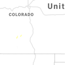
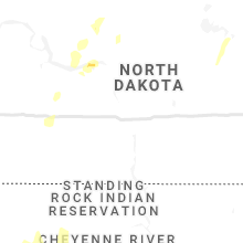
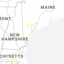
Hail Map for Saturday, June 6, 2020

Number of Impacted Households on 6/6/2020
0
Impacted by 1" or Larger Hail
0
Impacted by 1.75" or Larger Hail
0
Impacted by 2.5" or Larger Hail
Square Miles of Populated Area Impacted on 6/6/2020
0
Impacted by 1" or Larger Hail
0
Impacted by 1.75" or Larger Hail
0
Impacted by 2.5" or Larger Hail

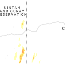
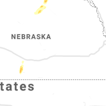


Cities Most Affected by Hail Storms of 6/6/2020
| Hail Size | Demographics of Zip Codes Affected | ||||||
|---|---|---|---|---|---|---|---|
| City | Count | Average | Largest | Pop Density | House Value | Income | Age |
| Blanding, UT | 2 | 1.75 | 1.75 | 10 | $87k | $32.0k | 27.7 |
| Oneill, NE | 1 | 1.75 | 1.75 | 9 | $72k | $31.6k | 44.5 |
| Monticello, UT | 1 | 1.75 | 1.75 | 0 | $94k | $34.0k | 33.7 |
| Spencer, NE | 1 | 1.75 | 1.75 | 2 | $33k | $29.5k | 50.4 |
Hail and Wind Damage Spotted on 6/6/2020
Filter by Report Type:Hail ReportsWind Reports
States Impacted
Nebraska, Maine, North Dakota, Utah, New Hampshire, Colorado, South Dakota, Massachusetts, Connecticut, New York, Wyoming, Nevada, Florida, West Virginia, Idaho, Virginia, New Mexico, Montana, MinnesotaNebraska
| Local Time | Report Details |
|---|---|
| 8:45 AM CDT | Quarter sized hail reported near Arapahoe, NE, 70 miles SE of North Platte, NE |
| 8:52 AM CDT | Quarter sized hail reported near Arapahoe, NE, 68.6 miles SE of North Platte, NE, quarter size hail covering highway 281 6 miles north of arapahoe. |
| 11:47 AM CDT | Golf Ball sized hail reported near Oneill, NE, 15.9 miles NNW of Oneill, NE, relayed from media... time estimated by radar. |
| 12:07 PM CDT | Ping Pong Ball sized hail reported near Oneill, NE, 19.5 miles N of Oneill, NE, relayed by media... time estimated by radar. |
| 12:15 PM CDT | Golf Ball sized hail reported near Spencer, NE, 23.6 miles N of Oneill, NE |
| 5:10 PM MDT | Awos station k1bw bravo madi in banner county NE, 29.3 miles SW of Scottsbluff, NE |
| 5:15 PM MDT | Awos station kibm kimbal airport - ib in kimball county NE, 47.1 miles S of Scottsbluff, NE |
| 5:35 PM MDT | West of hai in scotts bluff county NE, 0.6 miles NNE of Scottsbluff, NE |
| 5:42 PM MDT | Asos station kbff scottsbluff airport - bf in scotts bluff county NE, 4.3 miles E of Scottsbluff, NE |
| 5:44 PM MDT | Report from mping: 1-inch tree limbs broken; shingles blown of in scotts bluff county NE, 1.4 miles NNE of Scottsbluff, NE |
| 5:46 PM MDT | Scottsbluff airport asos sustained wind 46mph... 70mph wind gus in scotts bluff county NE, 3.8 miles E of Scottsbluff, NE |
| 5:47 PM MDT | Davis syste in scotts bluff county NE, 9.3 miles SE of Scottsbluff, NE |
| 5:49 PM MDT | Roof blown off / shingle damage hwy close in scotts bluff county NE, 9.3 miles NW of Scottsbluff, NE |
| 5:52 PM MDT | Measured on davis statio in cheyenne county NE, 46 miles SE of Scottsbluff, NE |
| 5:54 PM MDT | Pivot damage reported in scotts bluff county south of melbet in scotts bluff county NE, 9.3 miles SE of Scottsbluff, NE |
| 5:58 PM MDT | Storm damage reported in cheyenne county NE, 53 miles SSE of Scottsbluff, NE |
| 6:00 PM MDT | Asos station kbff scottsbluff airport - bf in scotts bluff county NE, 4.3 miles E of Scottsbluff, NE |
| 6:04 PM MDT | Nppd reports 3...361 customers without power in scottsbluff are in scotts bluff county NE, 1.3 miles NNW of Scottsbluff, NE |
| 6:04 PM MDT | Huge tree west of cr27 reported at lake minatare roa in scotts bluff county NE, 5.7 miles NE of Scottsbluff, NE |
| 6:05 PM MDT | Sidney airport asos reports 33mph sustained wind... gust of 64mp in cheyenne county NE, 63.1 miles SSE of Scottsbluff, NE |
| 6:05 PM MDT | Corrects previous tstm wnd dmg report from 1 nnw scottsbluff. railway cross beam broken reported at ave b... scottsbluf in scotts bluff county NE, 1.3 miles NNW of Scottsbluff, NE |
| 6:05 PM MDT | Corrects previous tstm wnd dmg report from 1 nnw scottsbluff. railway cross beam broken reported at ave b... scottsbluf in scotts bluff county NE, 1.3 miles NNW of Scottsbluff, NE |
| 6:06 PM MDT | Roof blown off a buildin in scotts bluff county NE, 0.9 miles SSW of Scottsbluff, NE |
| 6:07 PM MDT | Reports of 3 to 4 miles of power poles broken off 1 mile west of mcgre in scotts bluff county NE, 15.1 miles SE of Scottsbluff, NE |
| 6:07 PM MDT | Bayard and rural areas surrounding bayard reporting power outage in scotts bluff county NE, 17 miles ESE of Scottsbluff, NE |
| 6:07 PM MDT | Corrects time from previous tstm wnd dmg report from melbeta. several small outbuildings blown over in melbeta area. metal roofs stripped off. large trees blown over. s in scotts bluff county NE, 9.3 miles SE of Scottsbluff, NE |
| 6:07 PM MDT | Corrects time from previous tstm wnd dmg report from scottsbluff. tree blew over and came through the roof of a house in scottsbluff. no injuries reporte in scotts bluff county NE, 0.6 miles NNE of Scottsbluff, NE |
| 6:14 PM MDT | A shed blew over and hit a motorcyclist on highway 26 in mitchel in scotts bluff county NE, 9.3 miles NW of Scottsbluff, NE |
| 6:16 PM MDT | Measured on davis statio in box butte county NE, 44 miles ENE of Scottsbluff, NE |
| 6:20 PM MDT | Entire tree (3-4ã¢â€â™ diameter) uprooted in allianc in box butte county NE, 44 miles ENE of Scottsbluff, NE |
| 6:21 PM MDT | Raws agtn in sioux county NE, 38.7 miles N of Scottsbluff, NE |
| 6:21 PM MDT | Asos station kaia alliance airpor in box butte county NE, 46.3 miles ENE of Scottsbluff, NE |
| 6:24 PM MDT | Storm damage reported in sioux county NE, 73.3 miles N of Scottsbluff, NE |
| 6:25 PM MDT | Wind gusts of at least 60 mph in sheridan county NE, 53.1 miles ENE of Scottsbluff, NE |
| 6:29 PM MDT | Several small outbuildings blown over in melbeta area. metal roofs stripped off. large trees blown over. several pivots flipped ove in scotts bluff county NE, 9.3 miles SE of Scottsbluff, NE |
| 6:30 PM MDT | Tree blew over and came through the roof of a house in scottsbluff. no injuries reporte in scotts bluff county NE, 0.6 miles NNE of Scottsbluff, NE |
| 6:30 PM MDT | Multiple trees uprooted at bridgeport cemetery (2 miles west of bridgeport in morrill county NE, 30.1 miles ESE of Scottsbluff, NE |
| 6:37 PM MDT | 8 inch in diameter branches down. time estimated from rada in sheridan county NE, 67.1 miles NE of Scottsbluff, NE |
| 6:40 PM MDT | Storm damage reported in garden county NE, 65.2 miles E of Scottsbluff, NE |
| 6:49 PM MDT | Chadron... chadron municipal airpor in dawes county NE, 73.4 miles NNE of Scottsbluff, NE |
| 7:03 PM MDT | Storm damage reported in sheridan county NE, 81.6 miles W of Valentine, NE |
| 7:05 PM MDT | Storm damage reported in sheridan county NE, 83.9 miles W of Valentine, NE |
| 7:10 PM MDT | Storm damage reported in sheridan county NE, 83.9 miles W of Valentine, NE |
| 7:15 PM MDT | Sidney airport wind gust of 60mp in cheyenne county NE, 63.1 miles SSE of Scottsbluff, NE |
| 7:15 PM MDT | Power pole snapped along highway 20 at mm 117. report with photo via social media. time estimated from rada in cherry county NE, 73.3 miles W of Valentine, NE |
| 7:18 PM MDT | Storm damage reported in arthur county NE, 61.6 miles WNW of North Platte, NE |
| 7:20 PM MDT | Public report of minor structure blow overs due to estimated wind gust of 60mph at road 8/road 1 in cheyenne county NE, 63.9 miles SSE of Scottsbluff, NE |
| 7:22 PM MDT | Kings canyon mesonet site wind gust of 68mph at chadron state par in dawes county NE, 69.1 miles NNE of Scottsbluff, NE |
| 7:30 PM MDT | Mesonet station up252 8.1 w lodgepole (upr in cheyenne county NE, 66.3 miles SE of Scottsbluff, NE |
| 9:50 PM CDT | Asos station kvtn valentine airpor in cherry county NE, 0.3 miles S of Valentine, NE |
| 9:59 PM CDT | Storm damage reported in cherry county NE, 0.3 miles S of Valentine, NE |
Maine
| Local Time | Report Details |
|---|---|
| 9:55 AM EDT | Quarter sized hail reported near Porter, ME, 35.6 miles WNW of Portland, ME |
| 12:25 PM EDT | Trees dow in cumberland county ME, 33.9 miles NW of Portland, ME |
| 12:50 PM EDT | Trees and wires down. reported at querry road new glocuste in cumberland county ME, 23.8 miles NNW of Portland, ME |
| 12:55 PM EDT | Trees and wires down. reported at cobbs bridge road new glocuste in cumberland county ME, 22.2 miles N of Portland, ME |
| 12:55 PM EDT | Trees and wires down on tobey roa in cumberland county ME, 23.7 miles N of Portland, ME |
| 1:07 PM EDT | Quarter sized hail reported near Wells, ME, 33.3 miles SW of Portland, ME |
| 1:15 PM EDT | Large tree down in the roadwa in cumberland county ME, 21.3 miles NNW of Portland, ME |
| 1:25 PM EDT | Trees dow in cumberland county ME, 22.2 miles NNE of Portland, ME |
| 2:40 PM EDT | Multiple trees down in shapleig in york county ME, 30.9 miles WSW of Portland, ME |
| 2:40 PM EDT | Quarter sized hail reported near Shapleigh, ME, 31 miles WSW of Portland, ME |
| 2:42 PM EDT | Social media images of large pine tree dow in york county ME, 33.5 miles WSW of Portland, ME |
| 2:55 PM EDT | Trees dow in york county ME, 26.6 miles WSW of Portland, ME |
North Dakota
| Local Time | Report Details |
|---|---|
| 9:13 AM CDT | Quarter sized hail reported near Garrison, ND, 44.3 miles S of Minot, ND |
| 3:45 PM CDT | Quarter sized hail reported near Bottineau, ND, 57.9 miles NE of Minot, ND, very brief period of hail with a few the size of quarters. |
| 8:00 PM MDT | Reported 0.50 inch of rain which began at 850 pm cd in bowman county ND, 102 miles ESE of Miles City, MT |
| 8:15 PM MDT | No hail. rai in bowman county ND, 107.8 miles E of Miles City, MT |
| 8:24 PM MDT | Hettinger airpor in adams county ND, 104.5 miles WSW of Bismarck, ND |
| 8:30 PM MDT | The roof was completely removed from the west river health clinic. in bowman at highway 12 and 7th s in bowman county ND, 118.7 miles E of Miles City, MT |
| 8:52 PM MDT | Montana-dakota utilities reporting over 1000 homes without power due to severe storms. towns affected include mott... new england... regent... burt... and bentley. time in hettinger county ND, 79.7 miles WSW of Bismarck, ND |
| 12:15 AM CDT | Half Dollar sized hail reported near Minot, ND, 2.6 miles SSW of Minot, ND, report from mping: half dollar (1.25 in.). |
| 2:20 AM CDT | Quarter sized hail reported near Manvel, ND, 77.7 miles E of Devils Lake, ND |
Utah
| Local Time | Report Details |
|---|---|
| 9:40 AM MDT | Quarter sized hail reported near Mexican Hat, UT, 101.9 miles WNW of Farmington, NM, heavy rain also falling. |
| 9:55 AM MDT | Ping Pong Ball sized hail reported near Bluff, UT, 84 miles WNW of Farmington, NM, power lost briefly. conditions have improved. |
| 10:08 AM MDT | Quarter sized hail reported near Escalante, UT, 66.4 miles SSE of Monroe, UT |
| 10:10 AM MDT | Golf Ball sized hail reported near Blanding, UT, 93.9 miles NW of Farmington, NM |
| 10:15 AM MDT | Golf Ball sized hail reported near Blanding, UT, 93 miles NW of Farmington, NM |
| 10:27 AM MDT | Storm damage reported in san juan county UT, 93 miles NW of Farmington, NM |
| 10:30 AM MDT | Golf Ball sized hail reported near Monticello, UT, 92.3 miles SSW of Grand Junction, CO |
| 10:42 AM MDT | Half Dollar sized hail reported near Monticello, UT, 92.4 miles SSW of Grand Junction, CO |
| 11:45 AM MDT | Quarter sized hail reported near , , 56.6 miles NW of Grand Junction, CO, reported by fire crews on the seep ridge wildfire. |
| 12:27 PM MDT | Mesonet station uswu1 upr sand wsh... randlett 41s in uintah county UT, 64.5 miles NW of Grand Junction, CO |
| 12:27 PM MDT | Mesonet station upru1 upr p.r. canyon... mack 28n in uintah county UT, 47.8 miles NW of Grand Junction, CO |
| 12:27 PM MDT | Mesonet station mcku1 mccook ridge... mack 35n in uintah county UT, 54.1 miles NW of Grand Junction, CO |
| 12:48 PM MDT | Mesonet station whbu1 wildhors in uintah county UT, 48.2 miles E of Price, UT |
| 1:26 PM MDT | Mesonet station kpru1 kings point... jarvie ranch 5s in daggett county UT, 50.5 miles S of Rock Springs, WY |
| 1:27 PM MDT | Mesonet station diau1 diamond rim... vernal 19n in uintah county UT, 66.7 miles S of Rock Springs, WY |
| 3:54 PM MDT | Public estimated gust to 60 mph. numerous downed tree limbs and some shingles blown off of house. time estimated from rada in box elder county UT, 94.1 miles NNW of Salt Lake City, UT |
| 3:59 PM MDT | Chaulk hill - udot mesonet in box elder county UT, 87.8 miles NNW of Salt Lake City, UT |
New Hampshire
| Local Time | Report Details |
|---|---|
| 11:50 AM EDT | Tree and wires dow in merrimack county NH, 70.2 miles W of Portland, ME |
| 11:54 AM EDT | Trees and wires down. reported at cram road sanborto in belknap county NH, 66.3 miles W of Portland, ME |
| 11:56 AM EDT | Tree down on house. went through roof narrowly missing a sleeping baby. hill road tilto in belknap county NH, 64.3 miles W of Portland, ME |
| 11:58 AM EDT | Multiple trees down on horne roa in belknap county NH, 63 miles W of Portland, ME |
| 2:30 PM EDT | Half Dollar sized hail reported near Sanbornville, NH, 38.3 miles W of Portland, ME |
| 2:30 PM EDT | Report of 15-20 homes with damage due to fallen trees in wakefiel in carroll county NH, 39.3 miles W of Portland, ME |
| 2:36 PM EDT | Wires down... wind damag in belknap county NH, 52.6 miles WSW of Portland, ME |
Colorado
| Local Time | Report Details |
|---|---|
| 10:50 AM MDT | Quarter sized hail reported near Dolores, CO, 55.2 miles NNW of Farmington, NM |
| 11:53 AM MDT | Storm damage reported in mesa county CO, 24.1 miles NW of Grand Junction, CO |
| 12:15 PM MDT | Small and heavy rain accompanied win in mesa county CO, 23.9 miles E of Grand Junction, CO |
| 12:15 PM MDT | Received small hai in mesa county CO, 1.7 miles NNW of Grand Junction, CO |
| 12:18 PM MDT | Mesonet station drac2 dragon roa in rio blanco county CO, 61.3 miles NNW of Grand Junction, CO |
| 12:42 PM MDT | Mesonet station co073 surrey ridg in douglas county CO, 18.4 miles SSE of Denver, CO |
| 12:45 PM MDT | Storm damage reported in mesa county CO, 23.9 miles E of Grand Junction, CO |
| 12:48 PM MDT | Asos station kril garfield county rgnl a in garfield county CO, 54.9 miles NE of Grand Junction, CO |
| 1:02 PM MDT | Asos station keeo meeker airpor in rio blanco county CO, 36.5 miles SSW of Craig, CO |
| 1:11 PM MDT | Corrects previous non-tstm wnd gst report from 2 s wolf creek pass. awos station kcpw wolf creek pas in mineral county CO, 92.3 miles ENE of Farmington, NM |
| 1:28 PM MDT | Mesonet station tt290 rbfmz portable in moffat county CO, 53.4 miles SSE of Rock Springs, WY |
| 1:46 PM MDT | Mesonet station gdrc2 great divide 2s in moffat county CO, 23.2 miles NW of Craig, CO |
| 1:49 PM MDT | Report from mping: trees uprooted or snapped; roof blown of in routt county CO, 10 miles E of Craig, CO |
| 1:54 PM MDT | Awos station kccu red cliff pas in summit county CO, 64.3 miles WSW of Denver, CO |
| 1:54 PM MDT | Storm damage reported in summit county CO, 62 miles WSW of Denver, CO |
| 1:57 PM MDT | Mesonet station dhoc2 dead horse... buford 14en in rio blanco county CO, 31.4 miles SSE of Craig, CO |
| 2:09 PM MDT | Mesonet station co154 0.6 mi e of co-91 copper mt in summit county CO, 63.6 miles WSW of Denver, CO |
| 2:09 PM MDT | Tree knocked over by strong winds blocking traffic in both directions on emma road near mile marker in pitkin county CO, 83.4 miles SSE of Craig, CO |
| 2:12 PM MDT | Awos station k0co berthoud pas in grand county CO, 41.6 miles W of Denver, CO |
| 2:14 PM MDT | Storm damage reported in elbert county CO, 68.1 miles ESE of Denver, CO |
| 2:34 PM MDT | Storm damage reported in adams county CO, 59.2 miles WSW of Yuma, CO |
| 2:39 PM MDT | Mesonet station co158 2.4 mi e of silverthorn in summit county CO, 55.7 miles W of Denver, CO |
| 2:55 PM MDT | Quarter sized hail reported near Dinosaur, CO, 67.2 miles WSW of Craig, CO |
| 2:55 PM MDT | Trees down... partially blocking highway 4 in grand county CO, 43.5 miles WNW of Denver, CO |
| 3:00 PM MDT | Top of winter park ski are in grand county CO, 47.2 miles W of Denver, CO |
| 3:00 PM MDT | Storm damage reported in grand county CO, 42.2 miles WNW of Denver, CO |
| 3:02 PM MDT | Mesonet station co110 285s195 jefferso in park county CO, 52.7 miles WSW of Denver, CO |
| 3:10 PM MDT | Trees down near idlewil in grand county CO, 43.9 miles WNW of Denver, CO |
| 3:10 PM MDT | Tree down blocking lions gate driv in grand county CO, 44.2 miles WNW of Denver, CO |
| 3:10 PM MDT | Trees down blocking cars at devils thumb trailhea in grand county CO, 44.6 miles WNW of Denver, CO |
| 3:15 PM MDT | Storm damage reported in summit county CO, 62.1 miles WSW of Denver, CO |
| 3:25 PM MDT | Mesonet station ew4338 boulde in boulder county CO, 28.6 miles NW of Denver, CO |
| 3:26 PM MDT | Asos station kako akro in washington county CO, 26.6 miles W of Yuma, CO |
| 3:30 PM MDT | Numerous trees down... broken branches across canon cit in fremont county CO, 36.2 miles WNW of Pueblo, CO |
| 3:35 PM MDT | May have been a brief gustnad in larimer county CO, 40.3 miles N of Denver, CO |
| 3:39 PM MDT | Mesonet station cw8926 lakewoo in jefferson county CO, 9.7 miles WSW of Denver, CO |
| 3:39 PM MDT | 1-inch tree limbs broken; shingles blown of in jefferson county CO, 7.4 miles WSW of Denver, CO |
| 3:40 PM MDT | Tree down. time estimated from rada in arapahoe county CO, 6.2 miles S of Denver, CO |
| 3:40 PM MDT | Numerous 1 inch diameter tree limbs broke in boulder county CO, 19.7 miles NNW of Denver, CO |
| 3:41 PM MDT | Awos station kfnl ft collins love in larimer county CO, 49 miles N of Denver, CO |
| 3:42 PM MDT | 1-inch tree limbs broken; shingles blown of in arapahoe county CO, 11.7 miles SSE of Denver, CO |
| 3:42 PM MDT | 1-inch tree limbs broken; shingles blown of in denver county CO, 6.2 miles SE of Denver, CO |
| 3:43 PM MDT | 1-inch tree limbs broken; shingles blown of in jefferson county CO, 12.2 miles SSW of Denver, CO |
| 3:44 PM MDT | 1-inch tree limbs broken; shingles blown of in denver county CO, 2.3 miles NNW of Denver, CO |
| 3:44 PM MDT | Mesonet station co007 470w014 wadswort in jefferson county CO, 13.9 miles SSW of Denver, CO |
| 3:46 PM MDT | 1-inch tree limbs broken; shingles blown of in broomfield county CO, 12.8 miles NNW of Denver, CO |
| 3:50 PM MDT | Asos station kapa denver arapaho in arapahoe county CO, 14 miles SSE of Denver, CO |
| 3:50 PM MDT | 6 to 10 inch tree branches down. time estimated from rada in denver county CO, 3.1 miles ENE of Denver, CO |
| 3:51 PM MDT | 136th and zun in broomfield county CO, 13.9 miles N of Denver, CO |
| 3:51 PM MDT | 3-inch tree limbs broken; power poles broke in arapahoe county CO, 8.2 miles ESE of Denver, CO |
| 3:52 PM MDT | Mesonet station co035 076e125 sterlin in logan county CO, 41.9 miles NW of Yuma, CO |
| 3:54 PM MDT | Awos station kbkf buckley angb de in arapahoe county CO, 13 miles E of Denver, CO |
| 3:54 PM MDT | Mesonet station polc2 polhemu in douglas county CO, 34.6 miles SSW of Denver, CO |
| 3:55 PM MDT | 3-inch tree limbs broken; power poles broke in adams county CO, 13.3 miles N of Denver, CO |
| 3:55 PM MDT | Asos station kapa denver arapaho in arapahoe county CO, 14 miles SSE of Denver, CO |
| 3:56 PM MDT | Mesonet station aenc2 arsena in adams county CO, 8.9 miles NE of Denver, CO |
| 3:57 PM MDT | Mesonet station ctpc2 carpenter pea in douglas county CO, 22.6 miles SSW of Denver, CO |
| 3:57 PM MDT | Trees uprooted or snapped; roof blown of in arapahoe county CO, 8.1 miles ESE of Denver, CO |
| 3:57 PM MDT | Green houses and gazebo overturne in adams county CO, 14 miles N of Denver, CO |
| 3:58 PM MDT | Tree damage... too. 4-6 inch diameter limbs broke in adams county CO, 20.3 miles NNE of Denver, CO |
| 3:59 PM MDT | Storm damage reported in logan county CO, 51.3 miles N of Yuma, CO |
| 4:00 PM MDT | Awos station kbkf buckley angb de in arapahoe county CO, 13 miles E of Denver, CO |
| 4:00 PM MDT | Mesonet station co010 025s229 sh in broomfield county CO, 17.9 miles N of Denver, CO |
| 4:00 PM MDT | 3 inch branches and fences downe in adams county CO, 20.6 miles NNE of Denver, CO |
| 4:00 PM MDT | Large tree uprooted on downing near alamed in denver county CO, 2.4 miles SSE of Denver, CO |
| 4:01 PM MDT | Mesonet station fw3105 parke in douglas county CO, 23.6 miles SSE of Denver, CO |
| 4:01 PM MDT | Asos station kden denve in denver county CO, 19.7 miles ENE of Denver, CO |
| 4:02 PM MDT | 1-inch tree limbs broken; shingles blown of in weld county CO, 63.3 miles N of Denver, CO |
| 4:02 PM MDT | Mesonet station co171 nun in weld county CO, 59.3 miles SE of Laramie, WY |
| 4:04 PM MDT | Mesonet station ew9243 commerce cit in adams county CO, 14.9 miles NE of Denver, CO |
| 4:04 PM MDT | Shallow rooted trees pushed over. numerous power poles dow in arapahoe county CO, 12.9 miles SSE of Denver, CO |
| 4:06 PM MDT | Tree damage in tow in adams county CO, 19.7 miles NNE of Denver, CO |
| 4:06 PM MDT | Trees uprooted or snapped; roof blown of in weld county CO, 29.1 miles N of Denver, CO |
| 4:09 PM MDT | Storm damage reported in weld county CO, 30.9 miles NE of Denver, CO |
| 4:12 PM MDT | Trees uprooted or snapped; roof blown of in weld county CO, 25.9 miles NE of Denver, CO |
| 4:15 PM MDT | 1-inch tree limbs broken; shingles blown of in adams county CO, 26.3 miles NE of Denver, CO |
| 4:18 PM MDT | Storm damage reported in el paso county CO, 48.7 miles S of Denver, CO |
| 4:18 PM MDT | Storm damage reported in el paso county CO, 50.8 miles NNW of Pueblo, CO |
| 4:19 PM MDT | Storm damage reported in weld county CO, 58.1 miles NNE of Denver, CO |
| 4:22 PM MDT | Mesonet station co038 076e037 keenesbur in weld county CO, 34 miles NE of Denver, CO |
| 4:24 PM MDT | Storm damage reported in el paso county CO, 43.9 miles NNW of Pueblo, CO |
| 4:26 PM MDT | Storm damage reported in el paso county CO, 46.2 miles S of Denver, CO |
| 4:30 PM MDT | Awos station kmnh monument elber in elbert county CO, 40.3 miles SSE of Denver, CO |
| 4:34 PM MDT | Storm damage reported in elbert county CO, 68.1 miles ESE of Denver, CO |
| 4:34 PM MDT | Storm damage reported in weld county CO, 60 miles ESE of Laramie, WY |
| 4:34 PM MDT | 1-inch tree limbs broken; shingles blown of in morgan county CO, 58.1 miles W of Yuma, CO |
| 4:35 PM MDT | Awos station k1ow oscar madi in weld county CO, 70 miles SSW of Scottsbluff, NE |
| 4:40 PM MDT | 3 inch diamter branches dow in douglas county CO, 25.3 miles SSE of Denver, CO |
| 4:42 PM MDT | Mesonet station co072 070w304 bennet in adams county CO, 29.9 miles E of Denver, CO |
| 4:42 PM MDT | Mesonet station co039 076w067 wiggins bijou cree in morgan county CO, 61.6 miles NE of Denver, CO |
| 4:42 PM MDT | Storm damage reported in douglas county CO, 26.9 miles SSE of Denver, CO |
| 4:42 PM MDT | Asos station kcos colorado springs airpor in el paso county CO, 38.5 miles N of Pueblo, CO |
| 4:52 PM MDT | Mesonet station co072 070w304 bennet in adams county CO, 29.9 miles E of Denver, CO |
| 4:52 PM MDT | Mesonet station co073 surrey ridg in douglas county CO, 18.4 miles SSE of Denver, CO |
| 4:59 PM MDT | Trees uprooted or snapped; roof blown of in arapahoe county CO, 14.2 miles ESE of Denver, CO |
| 5:01 PM MDT | Mesonet station ew7240 ramah in elbert county CO, 56.8 miles SE of Denver, CO |
| 5:13 PM MDT | Storm damage reported in pueblo county CO, 6.4 miles ENE of Pueblo, CO |
| 5:14 PM MDT | Storm damage reported in logan county CO, 55.1 miles NNW of Yuma, CO |
| 5:15 PM MDT | Awos station kfmm fort morga in morgan county CO, 58.8 miles WNW of Yuma, CO |
| 5:18 PM MDT | Mesonet station cw5040 briggsdal in weld county CO, 78.3 miles ESE of Laramie, WY |
| 5:20 PM MDT | Mesonet station ew7966 elizabet in elbert county CO, 36.5 miles SE of Denver, CO |
| 5:32 PM MDT | Mesonet station co039 076w067 wiggins bijou cree in morgan county CO, 61.6 miles NE of Denver, CO |
| 5:33 PM MDT | Asos station klic limo in lincoln county CO, 77.3 miles SW of Yuma, CO |
| 5:46 PM MDT | Mesonet station dw6400 castle roc in douglas county CO, 28.5 miles SSE of Denver, CO |
| 5:55 PM MDT | Asos station kako akro in washington county CO, 26.6 miles W of Yuma, CO |
| 6:00 PM MDT | Storm damage reported in logan county CO, 47.7 miles NNW of Yuma, CO |
| 6:29 PM MDT | Storm damage reported in phillips county CO, 45.1 miles NNE of Yuma, CO |
| 6:40 PM MDT | Storm damage reported in sedgwick county CO, 65.5 miles NNE of Yuma, CO |
| 6:45 PM MDT | Yuma county em reports power outage near south buffalo and yuma are in yuma county CO, 0.8 miles NNE of Yuma, CO |
| 7:26 PM MDT | Storm damage reported in logan county CO, 51.3 miles N of Yuma, CO |
| 7:45 PM MDT | Mesonet station tt562 north sterlin in logan county CO, 54.3 miles NNW of Yuma, CO |
| 8:40 PM MDT | 2 inch diameter tree branches broke in sedgwick county CO, 64.9 miles NNE of Yuma, CO |
South Dakota
| Local Time | Report Details |
|---|---|
| 1:08 PM CDT | Quarter sized hail reported near Lake Andes, SD, 45 miles NNE of Oneill, NE |
| 5:32 PM CDT | Reports of multiple tree branches down in canova... a couple branches in the 6-8 inch diameter rang in miner county SD, 45.3 miles WNW of Sioux Falls, SD |
| 5:50 PM CDT | Trees dow in mccook county SD, 39.2 miles WNW of Sioux Falls, SD |
| 6:00 PM CDT | Storm damage reported in mccook county SD, 34.2 miles NW of Sioux Falls, SD |
| 6:26 PM CDT | Storm damage reported in lake county SD, 28.9 miles NW of Sioux Falls, SD |
| 6:29 PM CDT | Storm damage reported in minnehaha county SD, 25.3 miles NW of Sioux Falls, SD |
| 5:34 PM MDT | Storm damage reported in fall river county SD, 66.9 miles SW of Rapid City, SD |
| 5:49 PM MDT | 4 inch branches broken... trash dumpster blown away in custer county SD, 46.2 miles WSW of Rapid City, SD |
| 5:49 PM MDT | 4 inch branches broken... trash dumpster blown away in custer county SD, 46.2 miles WSW of Rapid City, SD |
| 6:02 PM MDT | Storm damage reported in custer county SD, 31.1 miles SW of Rapid City, SD |
| 6:08 PM MDT | Storm damage reported in pennington county SD, 30.5 miles W of Rapid City, SD |
| 7:09 PM CDT | Storm damage reported in moody county SD, 32.9 miles NNE of Sioux Falls, SD |
| 6:10 PM MDT | Storm damage reported in lawrence county SD, 29.2 miles WNW of Rapid City, SD |
| 6:14 PM MDT | Storm damage reported in lawrence county SD, 17.3 miles WNW of Rapid City, SD |
| 6:15 PM MDT | Storm damage reported in lawrence county SD, 31.8 miles NW of Rapid City, SD |
| 6:15 PM MDT | Storm damage reported in fall river county SD, 49.7 miles S of Rapid City, SD |
| 6:15 PM MDT | Storm damage reported in lawrence county SD, 42.5 miles NW of Rapid City, SD |
| 6:19 PM MDT | Storm damage reported in lawrence county SD, 17.3 miles WNW of Rapid City, SD |
| 6:20 PM MDT | Storm damage reported in pennington county SD, 17.3 miles WNW of Rapid City, SD |
| 6:20 PM MDT | Storm damage reported in lawrence county SD, 29.2 miles WNW of Rapid City, SD |
| 6:24 PM MDT | Storm damage reported in pennington county SD, 19.9 miles WSW of Rapid City, SD |
| 6:24 PM MDT | Storm damage reported in custer county SD, 27.7 miles S of Rapid City, SD |
| 6:30 PM MDT | Storm damage reported in pennington county SD, 4.2 miles S of Rapid City, SD |
| 6:34 PM MDT | Storm damage reported in custer county SD, 27.7 miles S of Rapid City, SD |
| 6:34 PM MDT | Storm damage reported in butte county SD, 63.4 miles NW of Rapid City, SD |
| 6:35 PM MDT | Storm damage reported in lawrence county SD, 39.6 miles NW of Rapid City, SD |
| 6:36 PM MDT | Storm damage reported in pennington county SD, 3.7 miles SSW of Rapid City, SD |
| 6:39 PM MDT | Storm damage reported in fall river county SD, 62.6 miles S of Rapid City, SD |
| 6:39 PM MDT | Storm damage reported in meade county SD, 8.5 miles NE of Rapid City, SD |
| 6:40 PM MDT | Storm damage reported in butte county SD, 44.4 miles NNW of Rapid City, SD |
| 6:43 PM MDT | Storm damage reported in pennington county SD, 2 miles NE of Rapid City, SD |
| 6:43 PM MDT | Storm damage reported in pennington county SD, 8.8 miles ESE of Rapid City, SD |
| 6:44 PM MDT | Storm damage reported in fall river county SD, 62.6 miles S of Rapid City, SD |
| 6:44 PM MDT | Storm damage reported in butte county SD, 61.7 miles NNW of Rapid City, SD |
| 6:54 PM MDT | Storm damage reported in fall river county SD, 62.6 miles S of Rapid City, SD |
| 6:55 PM MDT | Storm damage reported in butte county SD, 42.6 miles N of Rapid City, SD |
| 6:56 PM MDT | Storm damage reported in butte county SD, 80.4 miles NNW of Rapid City, SD |
| 6:57 PM MDT | Storm damage reported in pennington county SD, 8.8 miles ESE of Rapid City, SD |
| 7:00 PM MDT | Storm damage reported in pennington county SD, 15.2 miles E of Rapid City, SD |
| 7:05 PM MDT | Storm damage reported in oglala lakota county SD, 66.1 miles SSE of Rapid City, SD |
| 7:09 PM MDT | Storm damage reported in oglala lakota county SD, 80.9 miles SSE of Rapid City, SD |
| 7:11 PM MDT | Storm damage reported in lawrence county SD, 39.2 miles NW of Rapid City, SD |
| 7:15 PM MDT | Storm damage reported in oglala lakota county SD, 85.5 miles W of Valentine, NE |
| 7:19 PM MDT | Storm damage reported in meade county SD, 41.6 miles NE of Rapid City, SD |
| 7:19 PM MDT | Storm damage reported in harding county SD, 91 miles N of Rapid City, SD |
| 7:24 PM MDT | Storm damage reported in harding county SD, 91 miles N of Rapid City, SD |
| 7:25 PM MDT | Storm damage reported in oglala lakota county SD, 72.8 miles SE of Rapid City, SD |
| 7:33 PM MDT | Storm damage reported in oglala lakota county SD, 69.3 miles SE of Rapid City, SD |
| 7:33 PM MDT | Storm damage reported in harding county SD, 106 miles N of Rapid City, SD |
| 7:35 PM MDT | Storm damage reported in harding county SD, 107.3 miles ESE of Miles City, MT |
| 7:53 PM MDT | Storm damage reported in jackson county SD, 75.1 miles ESE of Rapid City, SD |
| 7:54 PM MDT | Storm damage reported in jackson county SD, 72.3 miles ESE of Rapid City, SD |
| 7:54 PM MDT | Storm damage reported in pennington county SD, 36.4 miles E of Rapid City, SD |
| 7:56 PM MDT | Storm damage reported in meade county SD, 55.3 miles NE of Rapid City, SD |
| 7:58 PM MDT | 76 mph wind gust measured... with sustained winds at 55 mph for two minutes. measured with vehicle mounted anemomete in jackson county SD, 76 miles WSW of Pierre, SD |
| 7:59 PM MDT | Storm damage reported in jackson county SD, 72.3 miles ESE of Rapid City, SD |
| 8:00 PM MDT | Storm damage reported in jackson county SD, 69.3 miles E of Rapid City, SD |
| 8:03 PM MDT | Two semi-trailer trucks flipped on i-90 at mm141 and mm14 in jackson county SD, 76.2 miles ESE of Rapid City, SD |
| 8:03 PM MDT | Two semi-trailer trucks flipped on i-90 at mm121 and mm12 in pennington county SD, 60.7 miles ESE of Rapid City, SD |
| 9:04 PM CDT | Storm damage reported in todd county SD, 41 miles NW of Valentine, NE |
| 8:05 PM MDT | Storm damage reported in jackson county SD, 69.1 miles NW of Valentine, NE |
| 8:08 PM MDT | Storm damage reported in perkins county SD, 78.8 miles NNE of Rapid City, SD |
| 8:15 PM MDT | Storm damage reported in meade county SD, 85.9 miles NE of Rapid City, SD |
| 9:16 PM CDT | Storm damage reported in mellette county SD, 48.5 miles NW of Valentine, NE |
| 8:20 PM MDT | Storm damage reported in haakon county SD, 68.3 miles ENE of Rapid City, SD |
| 8:25 PM MDT | Storm damage reported in meade county SD, 88.7 miles NE of Rapid City, SD |
| 9:28 PM CDT | Storm damage reported in todd county SD, 43.2 miles NW of Valentine, NE |
| 8:30 PM MDT | Storm damage reported in ziebach county SD, 71.6 miles ENE of Rapid City, SD |
| 8:34 PM MDT | Storm damage reported in perkins county SD, 91.7 miles SW of Bismarck, ND |
| 8:34 PM MDT | Storm damage reported in haakon county SD, 44 miles WSW of Pierre, SD |
| 8:34 PM MDT | Storm damage reported in jackson county SD, 49.4 miles SW of Pierre, SD |
| 8:39 PM MDT | Storm damage reported in meade county SD, 66.7 miles NNE of Rapid City, SD |
| 9:42 PM CDT | 18-wheeler blown off i-90 and into the media in jones county SD, 39.1 miles SSW of Pierre, SD |
| 8:45 PM MDT | Storm damage reported in perkins county SD, 98.6 miles SW of Bismarck, ND |
| 9:45 PM CDT | Storm damage reported in todd county SD, 24.1 miles NNW of Valentine, NE |
| 8:56 PM MDT | Report from mping: 1-inch tree limbs broken; shingles blown off. time estimated from rada in dewey county SD, 67.8 miles NW of Pierre, SD |
| 9:06 PM MDT | Time between 907pm and 1006p in corson county SD, 83.7 miles S of Bismarck, ND |
| 9:20 PM MDT | Time estimated from rada in dewey county SD, 85.7 miles NNW of Pierre, SD |
| 10:20 PM CDT | Mesonet station rfps2 vivian 13 in lyman county SD, 17.4 miles S of Pierre, SD |
| 10:27 PM CDT | Asos station kpir pierre muni a in hughes county SD, 3.6 miles ENE of Pierre, SD |
| 9:37 PM MDT | Gravel being lifted off the road by the win in dewey county SD, 45.7 miles N of Pierre, SD |
| 10:40 PM CDT | Storm damage reported in tripp county SD, 62.5 miles SSE of Pierre, SD |
Massachusetts
| Local Time | Report Details |
|---|---|
| 2:18 PM EDT | Tree and wires down at colton place in hampden county MA, 59.6 miles WNW of Providence, RI |
| 2:24 PM EDT | Tree down on brown ave in hampden county MA, 68.6 miles WNW of Providence, RI |
| 2:24 PM EDT | Tree down on brown ave in hampden county MA, 68.6 miles WNW of Providence, RI |
| 2:24 PM EDT | Tree down on brown ave in hampden county MA, 68.6 miles WNW of Providence, RI |
| 2:25 PM EDT | Tree down on birch hill rd in worcester county MA, 47.6 miles NW of Providence, RI |
| 2:40 PM EDT | Tree and wires down in worcester county MA, 38.4 miles WNW of Providence, RI |
| 2:44 PM EDT | Tree down on northwest rd in worcester county MA, 41.3 miles NW of Providence, RI |
| 2:46 PM EDT | Power pole down and leaning on wires on oak st in oxfor in worcester county MA, 33.7 miles NW of Providence, RI |
| 3:02 PM EDT | Wires down on south st in worcester county MA, 33.7 miles NW of Providence, RI |
| 3:02 PM EDT | Wires down on sutton ave in worcester county MA, 31.2 miles NW of Providence, RI |
| 3:06 PM EDT | Tree down on purgatory rd in worcester county MA, 25.6 miles NNW of Providence, RI |
| 3:10 PM EDT | Tree and large branches down in worcester county MA, 25.6 miles NNW of Providence, RI |
| 3:12 PM EDT | Tree down on car on southwick st near mendo in worcester county MA, 19.3 miles NNW of Providence, RI |
| 3:30 PM EDT | Trees down on bailey st in worcester county MA, 20.2 miles NNW of Providence, RI |
| 3:30 PM EDT | Tree down blocking angelo way via diablo dr in frankli in norfolk county MA, 19.1 miles N of Providence, RI |
| 3:38 PM EDT | Tree down on a house in cumberland r in providence county RI, 13.6 miles N of Providence, RI |
| 3:45 PM EDT | Power lines down on fales rd in north attleboro in bristol county MA, 10.3 miles NNE of Providence, RI |
| 3:58 PM EDT | Storm damage reported in norfolk county MA, 30.8 miles NNE of Providence, RI |
| 3:59 PM EDT | Trees down in bristol county MA, 9.3 miles NE of Providence, RI |
| 4:00 PM EDT | Trees and wires down on crane ave south in taunto in bristol county MA, 16.2 miles ENE of Providence, RI |
| 4:15 PM EDT | Multiple trees down on high st in bristol county MA, 10.9 miles NNE of Providence, RI |
| 4:15 PM EDT | Trees and powerlines down on grove st in hanove in plymouth county MA, 35.4 miles NE of Providence, RI |
| 4:15 PM EDT | Trees and power lines down on birchwood rd in hanove in plymouth county MA, 35.9 miles NE of Providence, RI |
| 4:51 PM EDT | Multiple trees down on winter green circle in essex county MA, 63 miles N of Providence, RI |
| 5:14 PM EDT | Tree down on car on southwick st in worcester county MA, 20.3 miles NNW of Providence, RI |
| 8:43 PM EDT | Tree down on chestnut st in worcester county MA, 43.6 miles NNW of Providence, RI |
| 8:47 PM EDT | Tree and wires down on neck rd in worcester county MA, 45.2 miles NNW of Providence, RI |
| 8:50 PM EDT | Tree down on sugar road in worcester county MA, 42.9 miles NNW of Providence, RI |
| 8:56 PM EDT | Quarter sized hail reported near Stow, MA, 42.1 miles N of Providence, RI |
| 9:02 PM EDT | Trees and power lines down on sudbury rd and whitman st in middlesex county MA, 42.1 miles N of Providence, RI |
| 9:11 PM EDT | Quarter sized hail reported near Sudbury, MA, 37.7 miles N of Providence, RI |
| 9:15 PM EDT | Tree down on house on fox run rd in middlesex county MA, 37.7 miles N of Providence, RI |
| 9:25 PM EDT | Multiple trees down kingsbury st... abbott st and washington st in norfolk county MA, 33.5 miles N of Providence, RI |
| 9:33 PM EDT | Tree down on avalon rd and oak st in middlesex county MA, 36.4 miles NNE of Providence, RI |
| 9:35 PM EDT | Tree down on car on curve st at great plain ave in norfolk county MA, 32.7 miles NNE of Providence, RI |
| 9:35 PM EDT | Tree down on car on curve st at great plain ave in norfolk county MA, 32.7 miles NNE of Providence, RI |
Connecticut
| Local Time | Report Details |
|---|---|
| 2:42 PM EDT | Large tree split in half... bringing a very large tree limb down... snapping a streetlight off of its pol in litchfield county CT, 78.9 miles SSE of Schenectady, NY |
| 3:16 PM EDT | Wires downed by winds on grove st in putnam in windham county CT, 25.9 miles WNW of Providence, RI |
| 3:18 PM EDT | Tree down on a house on viens s in windham county CT, 26.7 miles WNW of Providence, RI |
| 4:13 PM EDT | Trees reported dow in new london county CT, 35 miles WSW of Providence, RI |
| 4:13 PM EDT | Tree down on unoccupied car on hill s in new london county CT, 32.9 miles WSW of Providence, RI |
New York
| Local Time | Report Details |
|---|---|
| 3:10 PM EDT | Large tree limbs down. time estimated by rada in queens county NY, 13.9 miles ENE of Brooklyn, NY |
| 3:27 PM EDT | Large tree down at the intersection of high st. and circle dr. time estimated by rada in nassau county NY, 27.2 miles ENE of Brooklyn, NY |
| 3:29 PM EDT | Trees reported down through fences on radcliffe cour in nassau county NY, 27.2 miles ENE of Brooklyn, NY |
Wyoming
| Local Time | Report Details |
|---|---|
| 1:20 PM MDT | Snow springs raws reported 60 mph gust on 144 pm hourly observation. time estimated using rada in sweetwater county WY, 14.6 miles SE of Rock Springs, WY |
| 1:54 PM MDT | Bitter creek wydot anemometer along i-80 near milepost 142. gusts of 62 to 81 mph reported between 146 and 154 p in sweetwater county WY, 33.3 miles E of Rock Springs, WY |
| 1:58 PM MDT | Measured at the southwest wyoming regional airpor in sweetwater county WY, 8 miles E of Rock Springs, WY |
| 2:43 PM MDT | Mesonet station coww4 21 nne baggs - cow creek raws - co in carbon county WY, 54.9 miles N of Craig, CO |
| 2:46 PM MDT | Mesonet station kskl skyline (wydot in carbon county WY, 52.9 miles WSW of Laramie, WY |
| 2:52 PM MDT | Mesonet station wy15 14.5 e sinclair (wydot in carbon county WY, 71.3 miles WNW of Laramie, WY |
| 2:56 PM MDT | Mesonet station wy16 10.5 sw hanna (wydot in carbon county WY, 62.1 miles WNW of Laramie, WY |
| 3:02 PM MDT | Red canyon wydot anemometer in fremont county WY, 25.3 miles SSW of Riverton, WY |
| 3:06 PM MDT | Beaver rim wydot anemometer in fremont county WY, 26.2 miles SSE of Riverton, WY |
| 3:06 PM MDT | Mesonet station wy19 2.9 nw elk mountain (wydot in carbon county WY, 52.8 miles WNW of Laramie, WY |
| 3:12 PM MDT | Mesonet station karl 0.6 nw arlington (wydot in carbon county WY, 37.9 miles WNW of Laramie, WY |
| 3:28 PM MDT | Pathfinder wydot anemometer in natrona county WY, 33.3 miles SW of Casper, WY |
| 3:32 PM MDT | Mesonet station co128 085s309 wyoming borde in weld county CO, 47.8 miles ESE of Laramie, WY |
| 3:46 PM MDT | Storm damage reported in fremont county WY, 21.1 miles NE of Riverton, WY |
| 3:48 PM MDT | Storm damage reported in natrona county WY, 10.3 miles NW of Casper, WY |
| 3:50 PM MDT | Recorded at casper-natrona county international airport in natrona county WY, 6.2 miles NW of Casper, WY |
| 3:52 PM MDT | Mesonet station co128 085s309 wyoming borde in weld county CO, 47.8 miles ESE of Laramie, WY |
| 4:08 PM MDT | Smokey gap wydot anemometer in natrona county WY, 38.7 miles N of Casper, WY |
| 4:12 PM MDT | Tidsdale divide wydot anemometer in johnson county WY, 50.8 miles N of Casper, WY |
| 4:13 PM MDT | Deer creek 1-25 wy do in converse county WY, 23.8 miles E of Casper, WY |
| 4:16 PM MDT | Mesonet station kgun gun barrel (wydot in laramie county WY, 45.6 miles SW of Scottsbluff, NE |
| 4:16 PM MDT | Mesonet station kwyh 6.5 n natural fort (wydot in laramie county WY, 40.7 miles ESE of Laramie, WY |
| 4:18 PM MDT | Corrects previous tstm wnd gst report from 6 ene cheyenn in laramie county WY, 47.7 miles E of Laramie, WY |
| 4:19 PM MDT | Mesonet station cw2749 cheyenn in laramie county WY, 47.5 miles ESE of Laramie, WY |
| 4:23 PM MDT | Estimated report of 65-70 mph from a trained spotte in laramie county WY, 50.6 miles ESE of Laramie, WY |
| 4:25 PM MDT | Mesonet station up166 8.4 e north cheyenne (upr in laramie county WY, 50.3 miles E of Laramie, WY |
| 4:28 PM MDT | Storm damage reported in laramie county WY, 47.5 miles ESE of Laramie, WY |
| 4:30 PM MDT | Corrects previous tstm wnd gst report from 8 wsw hillsdale. wy46 i-80/us30 cheyenne eas in laramie county WY, 52.1 miles E of Laramie, WY |
| 4:32 PM MDT | Corrects previous tstm wnd gst report from 1 sse bordeaux. kbrx i-25/us8 in platte county WY, 54.4 miles NE of Laramie, WY |
| 4:32 PM MDT | Storm damage reported in campbell county WY, 48.6 miles SSW of Gillette, WY |
| 4:35 PM MDT | Corrects previous tstm wnd gst report from 3 nne douglas. kdg in converse county WY, 48.4 miles E of Casper, WY |
| 4:37 PM MDT | Storm damage reported in campbell county WY, 33.1 miles SSW of Gillette, WY |
| 4:40 PM MDT | Coleman mesonet site along i25-us26-us87 wind gust of 79mp in platte county WY, 74.8 miles ESE of Casper, WY |
| 4:46 PM MDT | Storm damage reported in campbell county WY, 48.6 miles SSW of Gillette, WY |
| 4:52 PM MDT | Dead horse wydot anemometer in johnson county WY, 30.2 miles W of Gillette, WY |
| 4:52 PM MDT | Mesonet station kgun gun barrel (wydot in laramie county WY, 45.6 miles SW of Scottsbluff, NE |
| 4:52 PM MDT | Wind gusts 60 to 75 mph beginning at 448 pm at the indian creek wydot anemometer in johnson county WY, 39.4 miles W of Gillette, WY |
| 4:52 PM MDT | Mesonet station estw4 23 s douglas - esterbrook raws - eb in converse county WY, 57.6 miles ESE of Casper, WY |
| 4:55 PM MDT | Awos station k82v pine bluffs airport - 82 in laramie county WY, 54.8 miles SSW of Scottsbluff, NE |
| 4:56 PM MDT | Storm damage reported in campbell county WY, 16 miles WSW of Gillette, WY |
| 5:02 PM MDT | Storm damage reported in campbell county WY, 25.3 miles S of Gillette, WY |
| 5:02 PM MDT | Storm damage reported in campbell county WY, 16 miles WSW of Gillette, WY |
| 5:05 PM MDT | Storm damage reported in campbell county WY, 55.3 miles SSE of Gillette, WY |
| 5:06 PM MDT | Storm damage reported in campbell county WY, 25.3 miles S of Gillette, WY |
| 5:06 PM MDT | Storm damage reported in campbell county WY, 16 miles WSW of Gillette, WY |
| 5:08 PM MDT | Storm damage reported in weston county WY, 52.6 miles SSE of Gillette, WY |
| 5:12 PM MDT | Storm damage reported in campbell county WY, 16 miles WSW of Gillette, WY |
| 5:13 PM MDT | Storm damage reported in campbell county WY, 3.7 miles NNW of Gillette, WY |
| 5:15 PM MDT | Some large tree branches dow in campbell county WY, 2.6 miles SSE of Gillette, WY |
| 5:15 PM MDT | Storm damage reported in campbell county WY, 2.9 miles ESE of Gillette, WY |
| 5:15 PM MDT | Storm damage reported in weston county WY, 38.4 miles SE of Gillette, WY |
| 5:15 PM MDT | Storm damage reported in weston county WY, 51.6 miles SE of Gillette, WY |
| 5:16 PM MDT | Corrects previous tstm wnd gst report from gun barrel. mesonet station kgun gun barrel (wydot in laramie county WY, 45.6 miles SW of Scottsbluff, NE |
| 5:20 PM MDT | Storm damage reported in campbell county WY, 4.4 miles SE of Gillette, WY |
| 5:22 PM MDT | Storm damage reported in campbell county WY, 20.6 miles NW of Gillette, WY |
| 5:26 PM MDT | Storm damage reported in goshen county WY, 36.5 miles W of Scottsbluff, NE |
| 5:27 PM MDT | Power outag in goshen county WY, 30.3 miles WNW of Scottsbluff, NE |
| 5:27 PM MDT | Storm damage reported in goshen county WY, 34 miles W of Scottsbluff, NE |
| 5:30 PM MDT | Power outage with trees blown down for much of torrington... w in goshen county WY, 29.8 miles WNW of Scottsbluff, NE |
| 5:34 PM MDT | Storm damage reported in crook county WY, 35.2 miles E of Gillette, WY |
| 5:35 PM MDT | Storm damage reported in weston county WY, 56 miles WSW of Rapid City, SD |
| 5:38 PM MDT | Storm damage reported in weston county WY, 63.8 miles SE of Gillette, WY |
| 5:40 PM MDT | Mental dumpster mangle in goshen county WY, 30.4 miles WNW of Scottsbluff, NE |
| 5:42 PM MDT | Storm damage reported in crook county WY, 43.9 miles E of Gillette, WY |
| 5:44 PM MDT | Storm damage reported in custer county SD, 45 miles WSW of Rapid City, SD |
| 5:49 PM MDT | Storm damage reported in campbell county WY, 50.4 miles NNE of Gillette, WY |
| 5:52 PM MDT | Storm damage reported in weston county WY, 45.2 miles W of Rapid City, SD |
| 6:05 PM MDT | Numerous sheds destroyed... tree branches up to 6 inch diameter broken... 3 fires started from power line in campbell county WY, 0.3 miles SE of Gillette, WY |
| 6:05 PM MDT | Numerous sheds destroyed... tree branches up to 6 inch diameter broken... 3 fires started from power line in campbell county WY, 0.3 miles SE of Gillette, WY |
| 6:12 PM MDT | Storm damage reported in crook county WY, 52.7 miles NW of Rapid City, SD |
| 6:15 PM MDT | Storm damage reported in crook county WY, 57.6 miles WNW of Rapid City, SD |
Nevada
| Local Time | Report Details |
|---|---|
| 1:03 PM PDT | Mesonet station rbvn2 ruby valley raw in elko county NV, 28.1 miles ESE of Elko, NV |
Florida
| Local Time | Report Details |
|---|---|
| 4:15 PM EDT | Trees and power lines were damaged by thunderstorm winds from belleview to summerfield along se 95th court... nw 20th ave... 92th loop and se 126th plac in marion county FL, 51.3 miles NW of Orlando, FL |
| 5:57 PM EDT | Tree reported down at 1609 long street in clearwate in pinellas county FL, 35.4 miles NNW of Bradenton, FL |
| 6:30 PM EDT | A member of the public reports a large tree limb down at the intersection of bear lake road and holliday road in forest cit in seminole county FL, 9.2 miles NNW of Orlando, FL |
| 7:32 PM EDT | Reports of tree damage in thornton park. possible tornado. time estimated from rada in orange county FL, 1.3 miles NE of Orlando, FL |
| 7:32 PM EDT | Orlando fire rescue on scene reported multiple trees and power lines down stretching from lake margaret dr to fern creek ave. possible tornad in orange county FL, 1.1 miles E of Orlando, FL |
| 8:32 PM EDT | Public reported trees downed and and strong winds estimated at 60-70mph in four corner in osceola county FL, 21 miles SW of Orlando, FL |
| 10:01 PM EDT | /corrected date/ i-95 closed at mile marker 261... 2 miles sw of the airport... due to debris in the road. siding and roof damage reported to some structures on mary mc in volusia county FL, 49.1 miles NNE of Orlando, FL |
West Virginia
| Local Time | Report Details |
|---|---|
| 5:02 PM EDT | One tree down along park av in roane county WV, 34.5 miles NNE of Charleston, WV |
| 11:31 PM EDT | Trees down across us 119 near pigeon cree in mingo county WV, 51.5 miles SW of Charleston, WV |
| 11:42 PM EDT | Trees down along hell creek roa in mingo county WV, 52.7 miles SW of Charleston, WV |
Idaho
| Local Time | Report Details |
|---|---|
| 4:20 PM MDT | Between the towns of pleasantview and malad city numerous uprooted trees... one damaging a house... and numerous power lines damaged and dow in oneida county ID, 93 miles S of Idaho Falls, ID |
| 6:30 PM MDT | Mesonet station 8419 d6 - kettle butt in bonneville county ID, 19.4 miles WNW of Idaho Falls, ID |
| 6:35 PM MDT | Mesonet station rov rove in jefferson county ID, 29.1 miles WNW of Idaho Falls, ID |
| 6:45 PM MDT | Mesonet station itdc5 d6 - fall rive in fremont county ID, 43.7 miles NE of Idaho Falls, ID |
| 6:55 PM MDT | Mesonet station ter terreto in jefferson county ID, 30.6 miles NW of Idaho Falls, ID |
| 7:10 PM MDT | Mesonet station ham hame in jefferson county ID, 37.1 miles NNW of Idaho Falls, ID |
| 7:15 PM MDT | Mesonet station itde3 d6 - cama in clark county ID, 47.1 miles NNW of Idaho Falls, ID |
| 7:20 PM MDT | Fremont county emergency manager reported numerous trees down across the county especially in and around ashton. nearby mesonet obs showed gusts in the 50-55 mph rang in fremont county ID, 49.7 miles NE of Idaho Falls, ID |
Virginia
| Local Time | Report Details |
|---|---|
| 7:15 PM EDT | One tree down on mcgufin road in warm spring in bath county VA, 56.2 miles N of Roanoke, VA |
| 8:15 PM EDT | Several trees down. time estimated by rada in westmoreland county VA, 60.9 miles NE of Richmond, VA |
| 8:30 PM EDT | Several trees down. time estimated by rada in westmoreland county VA, 67.3 miles NE of Richmond, VA |
| 8:45 PM EDT | Trees down reported at cheaneys bridge roa in essex county VA, 48 miles ENE of Richmond, VA |
| 8:50 PM EDT | Two trees down reported near king william courthous in king william county VA, 37.5 miles ENE of Richmond, VA |
| 8:50 PM EDT | Trees reported down. time estimated by rada in caroline county VA, 39.4 miles NNE of Richmond, VA |
| 9:05 PM EDT | Multiple trees down throughout county. time estimated by rada in lancaster county VA, 67.3 miles ENE of Richmond, VA |
| 9:25 PM EDT | Trees down at intersection of norwood rd and powcan r in king and queen county VA, 42.9 miles ENE of Richmond, VA |
| 9:50 PM EDT | Trees reported down along rt 60 (pocahontas trail). time estimated by rada in new kent county VA, 41.2 miles E of Richmond, VA |
| 10:09 PM EDT | Trees and power lines down reported at apache drive... deltaville... v in middlesex county VA, 57.8 miles NNW of Virginia Beach, VA |
| 10:15 PM EDT | Damage on boston rd... between pennyville and quail ln. numerous power outages in the are in accomack county VA, 61 miles NNE of Virginia Beach, VA |
| 11:13 PM EDT | Third island mesonet station xbb in anz632 county VA, 19.7 miles N of Virginia Beach, VA |
New Mexico
| Local Time | Report Details |
|---|---|
| 5:30 PM MDT | Kskx awo in taos county NM, 6.3 miles WNW of Taos, NM |
Montana
| Local Time | Report Details |
|---|---|
| 5:55 PM MDT | 1 large tree blown down on madison/gilbert street in helen in lewis and clark county MT, 72.2 miles SSW of Great Falls, MT |
| 6:18 PM MDT | Storm damage reported in carter county MT, 74.2 miles NE of Gillette, WY |
Minnesota
| Local Time | Report Details |
|---|---|
| 7:40 PM CDT | Time estimated from rada in pipestone county MN, 38.1 miles NNE of Sioux Falls, SD |
| 8:32 PM CDT | Storm damage reported in lyon county MN, 48.7 miles S of Montevideo, MN |
Connect with Interactive Hail Maps