

Hail Map for Wednesday, June 7, 2023

Number of Impacted Households on 6/7/2023
0
Impacted by 1" or Larger Hail
0
Impacted by 1.75" or Larger Hail
0
Impacted by 2.5" or Larger Hail
Square Miles of Populated Area Impacted on 6/7/2023
0
Impacted by 1" or Larger Hail
0
Impacted by 1.75" or Larger Hail
0
Impacted by 2.5" or Larger Hail


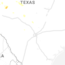


Cities Most Affected by Hail Storms of 6/7/2023
| Hail Size | Demographics of Zip Codes Affected | ||||||
|---|---|---|---|---|---|---|---|
| City | Count | Average | Largest | Pop Density | House Value | Income | Age |
| Sanderson, TX | 2 | 1.88 | 2.00 | 0 | $26k | $23.9k | 44.7 |
| Balmorhea, TX | 1 | 2.00 | 2.00 | 1 | $22k | $16.3k | 40.7 |
| Van Horn, TX | 1 | 2.00 | 2.00 | 0 | $32k | $25.0k | 37.9 |
| Argusville, ND | 1 | 1.75 | 1.75 | 8 | $93k | $48.3k | 35.1 |
Hail and Wind Damage Spotted on 6/7/2023
Filter by Report Type:Hail ReportsWind Reports
States Impacted
Georgia, South Carolina, North Dakota, Florida, Texas, Utah, Arkansas, Colorado, Idaho, Oklahoma, South Dakota, OregonGeorgia
| Local Time | Report Details |
|---|---|
| 3:00 PM EDT | Large tree branch down near the intersection of ga-208 and ga-31 in talbot county GA, 51 miles E of Auburn, AL |
| 3:37 PM EDT | Trees and powerlines down on little briar creek church road near ricketson roa in warren county GA, 34.6 miles WSW of Augusta, GA |
| 3:37 PM EDT | Trees and powerlines down at ricketson road near mt. pleasant roa in warren county GA, 34.1 miles WSW of Augusta, GA |
| 3:38 PM EDT | Trained spotter reports that a microburst occurred near mile marker 6 on interstate 16. trees down on both sides of the interstate with cars pulled off to the sid in bibb county GA, 81.4 miles SE of Atlanta, GA |
| 4:46 PM EDT | Trees down on south martin luther king jr. blvd near old dawson roa in sumter county GA, 82.3 miles ESE of Auburn, AL |
| 5:07 PM EDT | Trees down at intersection of vienna road and milford stree in macon county GA, 87 miles NW of Douglas, GA |
| 5:48 PM EDT | Trees down along oneil road near the forest chapel road intersectio in dooly county GA, 73.2 miles NW of Douglas, GA |
| 5:49 PM EDT | Trees down at intersection of clark street and railroad avenu in talbot county GA, 55.1 miles E of Auburn, AL |
| 5:58 PM EDT | Trees down near mile marker 115 on i-75 nort in dooly county GA, 68.7 miles NW of Douglas, GA |
| 6:00 PM EDT | Tree down at ralph smith rd and henry rowland rd... ne of midville. time estimate in burke county GA, 46.9 miles SSW of Augusta, GA |
| 6:12 PM EDT | Trees down on hwy 257 near friendship church roa in pulaski county GA, 59.9 miles NW of Douglas, GA |
| 6:48 PM EDT | Tree down on college ave in vidette. exact location not given. time estimate in burke county GA, 34.2 miles SSW of Augusta, GA |
| 6:56 PM EDT | Tree down on hills mill pond rd. time estimate in burke county GA, 32.9 miles SSW of Augusta, GA |
| 7:00 PM EDT | Multiple trees fell on shibar dr... including one that fell onto a house. time estimate in burke county GA, 30.8 miles SSW of Augusta, GA |
South Carolina
| Local Time | Report Details |
|---|---|
| 4:12 PM EDT | Trees and power lines down at shillings bridge rd and ferndale rd. time estimate in orangeburg county SC, 57.6 miles E of Augusta, GA |
| 4:16 PM EDT | Trees and power lines down at bamberg rd (us hwy 301/601) and poppy rd. time estimate in orangeburg county SC, 57.3 miles WNW of Charleston, SC |
| 4:26 PM EDT | Trees and power lines down at cannon bridge rd and carver school rd. time estimate in orangeburg county SC, 52.3 miles WNW of Charleston, SC |
| 4:26 PM EDT | Trees and power lines down at cannon bridge rd and river dr. time estimate in orangeburg county SC, 52.6 miles WNW of Charleston, SC |
| 4:30 PM EDT | Orangeburg co emergency manager reported around 20 trees knocked down in rowesville and vicinity... from cannon bridge rd and river dr east to the town of rowesville. n in orangeburg county SC, 48.8 miles WNW of Charleston, SC |
| 4:45 PM EDT | Tree down on oliver st in bowman. time estimate in orangeburg county SC, 40.6 miles WNW of Charleston, SC |
| 4:53 PM EDT | Tree down on interstate 26 eastbound at or near mile marker 161. time estimate in orangeburg county SC, 38.7 miles WNW of Charleston, SC |
| 4:54 PM EDT | Trees and down at atomic rd and double springs rd... between beech island and jackson. time estimate in aiken county SC, 11.7 miles SE of Augusta, GA |
| 6:35 PM EDT | A 911 call center relayed a report of a tree down along the 3500 block of blanding dr. time was estimated via radar dat in charleston county SC, 33.1 miles S of Charleston, SC |
| 6:40 PM EDT | A member of the public reported a large oak tree uprooted along red house roa in charleston county SC, 47.6 miles SSW of Charleston, SC |
| 8:09 PM EDT | One tree down at the 2000 block of bennetts point rd... blocking both lane in colleton county SC, 46.6 miles SW of Charleston, SC |
| 8:53 PM EDT | A 911 call center relayed a report of 3 trees down in roadway along castle rock rd near clearwater way. time was estimated via radar dat in beaufort county SC, 29.7 miles NE of Savannah, GA |
| 9:08 PM EDT | A 911 call center relayed a report of a tree down blocking the roadway on pumpkin hill rd near betsy kerrison pkwy. time was estimated via radar dat in charleston county SC, 39.8 miles SSW of Charleston, SC |
North Dakota
| Local Time | Report Details |
|---|---|
| 3:13 PM CDT | Corrects previous tstm wnd dmg report from 4 sw logan center. heavy crop damage to corn from strong winds and possibly hai in grand forks county ND, 51.6 miles ESE of Devils Lake, ND |
| 3:35 PM CDT | Quarter sized hail reported near Sharon, ND, 60.8 miles SE of Devils Lake, ND, law enforcement relayed report of windshield damage to vehicle from quarter size hail. |
| 3:58 PM CDT | Quarter sized hail reported near Finley, ND, 63 miles SE of Devils Lake, ND, report of nickel to quarter size hail by sheriff deparment. |
| 4:13 PM CDT | Heavy crop damage to corn from strong winds and possibly hai in grand forks county ND, 51.6 miles ESE of Devils Lake, ND |
| 4:40 PM CDT | Golf Ball sized hail reported near Argusville, ND, 15.2 miles NW of Fargo, ND, just west of argusville report of golf ball size hail from broadcast media. |
| 5:46 PM CDT | Semi blown off the roa in barnes county ND, 49.7 miles W of Fargo, ND |
| 5:50 PM CDT | Semi blown ove in barnes county ND, 51.6 miles W of Fargo, ND |
| 6:20 PM CDT | Large trees snapped a couple feet above the ground: picture via twitte in richland county ND, 28 miles SW of Fargo, ND |
| 9:20 PM CDT | Mesonet station 320949 6 sse roth (ndawn in bottineau county ND, 47.3 miles NNE of Minot, ND |
Florida
| Local Time | Report Details |
|---|---|
| 4:59 PM EDT | The kxmr asos measured a 61 mph/53 kt wind gust from the west-northwes in brevard county FL, 49.3 miles E of Orlando, FL |
| 5:20 PM EDT | Trained spotter reports possible tornado damage near skylark blvd and south patrick dr. extending east to flamingo dr. damage to carports and roofs of multiple homes. a in brevard county FL, 52.5 miles ESE of Orlando, FL |
| 5:27 PM EDT | The klee asos measured a 58 mph/50 kt wind gust from the southwes in lake county FL, 32.7 miles NW of Orlando, FL |
Texas
| Local Time | Report Details |
|---|---|
| 4:25 PM CDT | Ping Pong Ball sized hail reported near Fort Stockton, TX, 36.9 miles NNE of Alpine, TX |
| 5:24 PM CDT | Ping Pong Ball sized hail reported near Balmorhea, TX, 45.1 miles N of Alpine, TX, ping pong ball sized hail observed along i-10 near balmorhea. |
| 5:35 PM CDT | Hen Egg sized hail reported near Balmorhea, TX, 43 miles N of Alpine, TX, 2 inch diameter hail observed on the south side of balmorhea. |
| 5:40 PM CDT | Hen Egg sized hail reported near Van Horn, TX, 83.7 miles NW of Alpine, TX |
| 5:54 PM CDT | Quarter sized hail reported near , , 46.2 miles ENE of Alpine, TX, report from mping: quarter (1.00 in.). |
| 5:56 PM CDT | Golf Ball sized hail reported near , , 48.9 miles ENE of Alpine, TX, quarter to golf ball size hail. |
| 6:01 PM CDT | Ping Pong Ball sized hail reported near , , 46 miles ENE of Alpine, TX, report from mping: ping pong ball (1.50 in.). |
| 7:54 PM CDT | Golf Ball sized hail reported near Sanderson, TX, 59.6 miles ESE of Alpine, TX |
| 7:58 PM CDT | Hen Egg sized hail reported near Sanderson, TX, 60.9 miles ESE of Alpine, TX |
| 8:21 PM CDT | Quarter sized hail reported near Andrews, TX, 34.4 miles NNW of Odessa, TX, report from mping: quarter (1.00 in.). |
| 9:06 PM CDT | Mesonet station 72 big bend np/brewster count in brewster county TX, 56.2 miles SSE of Alpine, TX |
| 9:19 PM CDT | Mesonet station 48 2e andrews in andrews county TX, 33.5 miles NNW of Odessa, TX |
| 9:55 PM CDT | Mesonet station 84 2wnw tarzan tarzan/martin count in martin county TX, 38.3 miles NE of Odessa, TX |
| 10:10 PM CDT | Mesonet station 18 lamesa 2s in dawson county TX, 61 miles S of Lubbock, TX |
| 10:42 PM CDT | Mesonet station 77 1sse lomax lomax/howard count in howard county TX, 47 miles ENE of Odessa, TX |
| 11:11 PM CDT | Mesonet station 31 fluvanna 3 in borden county TX, 61 miles SE of Lubbock, TX |
| 11:34 PM CDT | Mesonet station ur103 2.2 e colorado city (upr in mitchell county TX, 63.2 miles W of Abilene, TX |
| 1:23 AM CDT | Storm damage reported in val verde county TX, 7.1 miles E of Del Rio, TX |
Utah
| Local Time | Report Details |
|---|---|
| 4:00 PM MDT | Murrays hill mesonet site in cache county UT, 58.8 miles N of Salt Lake City, UT |
| 4:50 PM MDT | Sr-30 mesonet site in cache county UT, 70.8 miles N of Salt Lake City, UT |
Arkansas
| Local Time | Report Details |
|---|---|
| 5:20 PM CDT | Several large tree limbs down in black oak. pictures relayed via social media. time estimated from rada in washington county AR, 45.3 miles NNE of Fort Smith, AR |
Colorado
| Local Time | Report Details |
|---|---|
| 4:47 PM MDT | Mesonet station co118 070e051 beaver tail tunne in mesa county CO, 18.2 miles ENE of Grand Junction, CO |
Idaho
| Local Time | Report Details |
|---|---|
| 5:25 PM MDT | Storm damage reported in ada county ID, 1.4 miles WSW of Boise, ID |
| 5:25 PM MDT | Numerous reports of tree damage... large branches down... via social medi in ada county ID, 0.7 miles ENE of Boise, ID |
| 5:25 PM MDT | Numerous reports of tree damage... large branches down... via social medi in ada county ID, 0.7 miles ENE of Boise, ID |
| 5:28 PM MDT | Mesonet station tt289 crestline trai in ada county ID, 2 miles NE of Boise, ID |
| 5:30 PM MDT | Large tree branches down 2 blocks s of bsu campu in ada county ID, 0.7 miles ENE of Boise, ID |
| 5:43 PM MDT | Tree down on park center and highland blocking several lane in ada county ID, 1.4 miles WSW of Boise, ID |
Oklahoma
| Local Time | Report Details |
|---|---|
| 6:55 PM CDT | Quarter sized hail reported near Lane, OK, 9.9 miles SE of Atoka, OK |
South Dakota
| Local Time | Report Details |
|---|---|
| 8:22 PM CDT | Mesonet station 2 lake city (sddot in marshall county SD, 54.8 miles ENE of Aberdeen, SD |
| 8:35 PM CDT | Awos station k8d3 2 e sisseto in roberts county SD, 73.6 miles ENE of Aberdeen, SD |
Oregon
| Local Time | Report Details |
|---|---|
| 8:34 PM PDT | Quarter sized hail reported near Medford, OR, 2.1 miles ESE of Medford, OR, verified quarter size hail via photo. |
Connect with Interactive Hail Maps