

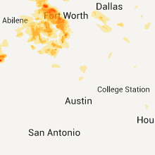
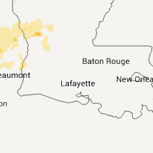
Hail Map for Tuesday, May 26, 2015

Number of Impacted Households on 5/26/2015
0
Impacted by 1" or Larger Hail
0
Impacted by 1.75" or Larger Hail
0
Impacted by 2.5" or Larger Hail
Square Miles of Populated Area Impacted on 5/26/2015
0
Impacted by 1" or Larger Hail
0
Impacted by 1.75" or Larger Hail
0
Impacted by 2.5" or Larger Hail


Cities Most Affected by Hail Storms of 5/26/2015
| Hail Size | Demographics of Zip Codes Affected | ||||||
|---|---|---|---|---|---|---|---|
| City | Count | Average | Largest | Pop Density | House Value | Income | Age |
| El Dorado, KS | 5 | 2.05 | 2.75 | 63 | $66k | $35.2k | 35.5 |
| Ames, OK | 2 | 3.00 | 3.00 | 4 | $48k | $30.6k | 44.3 |
| Miles, TX | 2 | 2.25 | 2.75 | 7 | $59k | $35.9k | 39.0 |
| Mountain View, OK | 2 | 2.25 | 2.50 | 4 | $33k | $24.9k | 46.4 |
| Drummond, OK | 2 | 2.13 | 2.50 | 7 | $63k | $38.3k | 37.0 |
| Gordon, TX | 2 | 2.13 | 2.50 | 6 | $55k | $35.9k | 51.7 |
| Hastings, OK | 2 | 1.75 | 1.75 | 8 | $44k | $24.7k | 52.9 |
| Crescent, OK | 1 | 2.50 | 2.50 | 19 | $54k | $30.6k | 41.6 |
| Lahoma, OK | 1 | 2.50 | 2.50 | 25 | $55k | $36.5k | 40.6 |
| Frederick, OK | 1 | 2.00 | 2.00 | 13 | $28k | $23.3k | 39.5 |
| Carrier, OK | 1 | 2.00 | 2.00 | 4 | $36k | $37.8k | 41.7 |
| Olney, TX | 1 | 2.00 | 2.00 | 15 | $34k | $25.4k | 42.7 |
| Rowena, TX | 1 | 1.75 | 1.75 | 4 | $47k | $30.7k | 43.1 |
| Shreveport, LA | 1 | 1.75 | 1.75 | 1832 | $41k | $21.8k | 34.5 |
| Watonga, OK | 1 | 1.75 | 1.75 | 16 | $47k | $27.7k | 33.5 |
| Wichita Falls, TX | 1 | 1.75 | 1.75 | 25 | $73k | $36.3k | 45.4 |
| Comanche, OK | 1 | 1.75 | 1.75 | 23 | $41k | $29.9k | 40.9 |
| Comanche, TX | 1 | 1.75 | 1.75 | 16 | $45k | $29.4k | 43.0 |
| Enid, OK | 1 | 1.75 | 1.75 | 170 | $39k | $26.6k | 33.1 |
| Stephenville, TX | 1 | 1.75 | 1.75 | 61 | $72k | $30.6k | 29.6 |
| Ranger, TX | 1 | 1.75 | 1.75 | 11 | $23k | $24.2k | 41.4 |
Hail and Wind Damage Spotted on 5/26/2015
Filter by Report Type:Hail ReportsWind Reports
States Impacted
Illinois, Georgia, Alabama, Oklahoma, Wisconsin, Indiana, Ohio, Florida, Kentucky, South Carolina, Michigan, Texas, West Virginia, Kansas, Wyoming, Louisiana, IdahoIllinois
| Local Time | Report Details |
|---|---|
| 8:10 AM CDT | Tree down on route 101. time estimate in schuyler county IL, 58.5 miles ESE of Kahoka, MO |
| 10:01 AM CDT | Morton building distroyed and home damaged - possible tornado in henry county IL, 54.9 miles NNW of Peoria, IL |
| 10:55 AM CDT | Trees damaged in ladd. barn destroyed 1 mile northeast of ladd. all damage blown to the northeast as reported by media. time approximated by rada in bureau county IL, 51.4 miles NNE of Peoria, IL |
| 1:00 PM CDT | Electrical pole cracked at the base in the 7300 block of 62nd place. from summit public work in cook county IL, 12.1 miles SW of Chicago, IL |
| 1:00 PM CDT | 5 inch diameter tree branch fell on a truck in the 5600 block of south new england ave. numerous other branches of varying diameters down. street lights blown down at 5 in cook county IL, 11.2 miles SW of Chicago, IL |
| 1:25 PM CDT | Storm damage reported in lmz741 county IL, 4.1 miles NE of Chicago, IL |
Georgia
| Local Time | Report Details |
|---|---|
| 12:40 PM EDT | Half a roof blown off a mobile home on lane bridge road in seminole county GA, 50.9 miles NW of Tallahassee, FL |
| 12:44 PM EDT | Tree down on power line in town in seminole county GA, 54.6 miles NW of Tallahassee, FL |
| 2:15 PM EDT | Tree down on hwy 82 w in springval in randolph county GA, 64.1 miles SSE of Auburn, AL |
| 2:40 PM EDT | A tree was blown down on south river road near the boat launc in heard county GA, 48.2 miles NNE of Auburn, AL |
| 2:42 PM EDT | A tree was blown down on greenwood lake driv in heard county GA, 46.8 miles SW of Atlanta, GA |
| 3:19 PM EDT | Tree down blocking all lanes at mineral springs road and canton hwy in ball ground. time estimated from rada in cherokee county GA, 40.8 miles N of Atlanta, GA |
| 3:30 PM EDT | Numerous trees down in the fortson and cataula areas...some on roof in harris county GA, 35.8 miles E of Auburn, AL |
| 3:30 PM EDT | Trees and powerlines down in many locations including buena vista rd...christine rd...solomon rd...macon rd...river rd...and woolrich r in muscogee county GA, 30.4 miles ESE of Auburn, AL |
| 3:32 PM EDT | Several trees down along and across jones road and bonacre roa in harris county GA, 33.4 miles E of Auburn, AL |
| 3:37 PM EDT | Numerous trees were blown down in pine mountain valle in harris county GA, 40.8 miles ENE of Auburn, AL |
| 3:41 PM EDT | Numerous trees snapped along phillips road. possible structural damage. time estimated from rada in meriwether county GA, 49 miles ENE of Auburn, AL |
| 3:55 PM EDT | Multiple trees and powerlines down north of woodbur in meriwether county GA, 52.2 miles SSW of Atlanta, GA |
| 4:05 PM EDT | Trees and powerlines down robinson road and hwy 5 in coweta county GA, 38.4 miles SW of Atlanta, GA |
| 4:07 PM EDT | Trees down along robinson road and old carrollton hwy in coweta county GA, 34.5 miles SW of Atlanta, GA |
| 4:16 PM EDT | Trees down along the intersection of gordon road and al roberts road. trees down on seavy street near hwy 85 in coweta county GA, 32.2 miles SSW of Atlanta, GA |
| 4:30 PM EDT | Tree down blocking road at clear springs lane and smokerise point. time estimated from rada in fayette county GA, 24 miles SSW of Atlanta, GA |
| 4:36 PM EDT | Trees down in clayton county blocking roads. innman road and panhandle road...riverdale rd and east fayetteville roa in clayton county GA, 24.7 miles S of Atlanta, GA |
| 4:44 PM EDT | Couple of trees down. one on north oak street and one on loch laurel road in lowndes county GA, 49.8 miles SSW of Douglas, GA |
| 4:45 PM EDT | A tree blew down at the intersection chambers and jonesboro r in henry county GA, 21.9 miles SSE of Atlanta, GA |
| 4:54 PM EDT | Power transformer and tree down on hous in bibb county GA, 69.5 miles SSE of Atlanta, GA |
| 4:55 PM EDT | Trees and powerlines down at the intersection of hillcrest ave and pio nono ave in maco in bibb county GA, 75.6 miles SE of Atlanta, GA |
| 5:20 PM EDT | Numerous trees and powerlines down in covington but also reports all across the count in newton county GA, 32.3 miles ESE of Atlanta, GA |
| 5:33 PM EDT | Powerlines down along hwy 14 in jasper county GA, 54.8 miles ESE of Atlanta, GA |
| 5:37 PM EDT | Couple of trees down along hwy 16 west of eatonton. time estimated by rada in putnam county GA, 60.6 miles ESE of Atlanta, GA |
| 5:44 PM EDT | Tree down in the city of willacooche in atkinson county GA, 16.4 miles SW of Douglas, GA |
| 5:44 PM EDT | Several trees down along hwy 83 near bostwick. time estimated from rada in morgan county GA, 50.2 miles E of Atlanta, GA |
| 5:49 PM EDT | Trees down around statham near the intersection of hammond rd and rat kinney rd. time estimated from rada in barrow county GA, 49.1 miles ENE of Atlanta, GA |
| 6:05 PM EDT | Several trees and power lines were blown down. hardest hit area was in the lexington rd and oconee street are in clarke county GA, 60.9 miles ENE of Atlanta, GA |
| 6:24 PM EDT | Trees dow in hart county GA, 45.1 miles SSW of Greenville, SC |
| 7:10 PM EDT | Tree and a powerline down at norman gillis road and us highway 158. time of damage estimated by rada in ware county GA, 18.2 miles SE of Douglas, GA |
Alabama
| Local Time | Report Details |
|---|---|
| 12:20 PM CDT | 1 tree down in cottonwood in houston county AL, 73.8 miles NW of Tallahassee, FL |
Oklahoma
| Local Time | Report Details |
|---|---|
| 1:11 PM CDT | Quarter sized hail reported near Lawton, OK, 45.7 miles NNE of Wichita Falls, TX, public report relayed by kswo tv. |
| 2:25 PM CDT | Quarter sized hail reported near Oklahoma City, OK, 6.6 miles SSW of Oklahoma City, OK, reported by koco tv |
| 2:29 PM CDT | Quarter sized hail reported near Oklahoma City, OK, 7.2 miles SW of Oklahoma City, OK, nickel to quarter size hail at 74th and may at occc. |
| 2:42 PM CDT | Quarter sized hail reported near Oklahoma City, OK, 0.6 miles ESE of Oklahoma City, OK |
| 2:50 PM CDT | Ping Pong Ball sized hail reported near Oklahoma City, OK, 3.6 miles ENE of Oklahoma City, OK |
| 3:05 PM CDT | Ping Pong Ball sized hail reported near Jones, OK, 15.6 miles NE of Oklahoma City, OK, near turner turnpike west of hiwassee road. |
| 3:06 PM CDT | Quarter sized hail reported near Luther, OK, 21.3 miles NE of Oklahoma City, OK |
| 3:10 PM CDT | Quarter sized hail reported near Jones, OK, 16.1 miles NE of Oklahoma City, OK, waterloo and luther road. |
| 3:10 PM CDT | Quarter sized hail reported near Luther, OK, 25.3 miles NE of Oklahoma City, OK, waterloo and luther road. |
| 3:32 PM CDT | Quarter sized hail reported near Ripley, OK, 51.4 miles NE of Oklahoma City, OK |
| 5:05 PM CDT | Quarter sized hail reported near Davidson, OK, 42.4 miles NW of Wichita Falls, TX |
| 5:11 PM CDT | Hen Egg sized hail reported near Frederick, OK, 40.7 miles NW of Wichita Falls, TX |
| 5:50 PM CDT | Hen Egg sized hail reported near Mountain View, OK, 74.8 miles WSW of Oklahoma City, OK |
| 6:32 PM CDT | Golf Ball sized hail reported near Hastings, OK, 31.5 miles NE of Wichita Falls, TX |
| 6:33 PM CDT | Golf Ball sized hail reported near Hastings, OK, 25.3 miles NE of Wichita Falls, TX |
| 6:56 PM CDT | Half Dollar sized hail reported near Comanche, OK, 44 miles NE of Wichita Falls, TX |
| 6:59 PM CDT | Golf Ball sized hail reported near Comanche, OK, 44.1 miles NE of Wichita Falls, TX |
| 7:00 PM CDT | Half Dollar sized hail reported near Duncan, OK, 51.2 miles NE of Wichita Falls, TX |
| 7:04 PM CDT | Quarter sized hail reported near Duncan, OK, 51.2 miles NE of Wichita Falls, TX |
| 7:38 PM CDT | Tea Cup sized hail reported near Ames, OK, 63.4 miles NW of Oklahoma City, OK |
| 7:45 PM CDT | Tea Cup sized hail reported near Ames, OK, 63 miles NNW of Oklahoma City, OK |
| 7:55 PM CDT | Golf Ball sized hail reported near Drummond, OK, 64.9 miles NNW of Oklahoma City, OK |
| 7:57 PM CDT | Half Dollar sized hail reported near Chickasha, OK, 35.7 miles SSW of Oklahoma City, OK |
| 8:02 PM CDT | Half Dollar sized hail reported near Drummond, OK, 65.9 miles NNW of Oklahoma City, OK |
| 8:08 PM CDT | Tennis Ball sized hail reported near Lahoma, OK, 69.8 miles NNW of Oklahoma City, OK |
| 8:19 PM CDT | Quarter sized hail reported near Enid, OK, 67.1 miles NNW of Oklahoma City, OK |
| 8:23 PM CDT | Hen Egg sized hail reported near Carrier, OK, 75.6 miles NNW of Oklahoma City, OK |
| 8:28 PM CDT | Tennis Ball sized hail reported near Drummond, OK, 64.1 miles NNW of Oklahoma City, OK |
| 8:44 PM CDT | Golf Ball sized hail reported near Enid, OK, 72.4 miles NNW of Oklahoma City, OK, at highway 81 and keeowee. |
| 8:59 PM CDT | Half Dollar sized hail reported near Carnegie, OK, 66.2 miles WSW of Oklahoma City, OK |
| 9:00 PM CDT | Tennis Ball sized hail reported near Mountain View, OK, 68.3 miles WSW of Oklahoma City, OK |
| 9:22 PM CDT | Two 12-inch diameter trees down in blaine county OK, 61.2 miles WNW of Oklahoma City, OK |
| 9:53 PM CDT | Golf Ball sized hail reported near Watonga, OK, 56.4 miles WNW of Oklahoma City, OK |
| 10:48 PM CDT | Tennis Ball sized hail reported near Crescent, OK, 38 miles N of Oklahoma City, OK |
| 1:00 AM CDT | Power lines blown down. time estimated from rada in muskogee county OK, 44.5 miles SE of Tulsa, OK |
Wisconsin
| Local Time | Report Details |
|---|---|
| 1:40 PM CDT | Around 20 trees down near the corner of homelane and stratton lake roads. some trees greater than 1 foot in diameter. tree on a garage at corner of homelane and mynard in waupaca county WI, 57.5 miles WSW of Green Bay, WI |
Indiana
| Local Time | Report Details |
|---|---|
| 3:30 PM EDT | One end of a pole barn pushed in along with several tree limbs downed. near the intersection of 200n and 500e east of hillsboro. time estimated by rada in henry county IN, 45.9 miles ENE of Indianapolis, IN |
| 3:35 PM EDT | Large tree limb down. time estimated from rada in ripley county IN, 33.6 miles W of Cincinnati, OH |
Ohio
| Local Time | Report Details |
|---|---|
| 3:58 PM EDT | One tree fell across guernsey dell av in montgomery county OH, 50.8 miles NNE of Cincinnati, OH |
| 3:59 PM EDT | One small limb down. time estimated from rada in franklin county OH, 3.5 miles SW of Columbus, OH |
| 4:08 PM EDT | One tree down. time estimated from rada in darke county OH, 62.6 miles SSE of Fort Wayne, IN |
| 4:20 PM EDT | One large limb down. time estimated from rada in preble county OH, 44.9 miles N of Cincinnati, OH |
| 4:35 PM EDT | Camper destroyed by damaging winds. time estimated from rada in auglaize county OH, 57.8 miles SE of Fort Wayne, IN |
| 4:41 PM EDT | Roof peeled off building and several large trees down. time estimated from rada in auglaize county OH, 57.5 miles SE of Fort Wayne, IN |
| 4:45 PM EDT | A 2 year old roof was blown off of a hog barn near the intersection of southworth rd and zion church rd near spencerville. barn is about 100 yards long. time estimated in allen county OH, 44.5 miles ESE of Fort Wayne, IN |
| 4:46 PM EDT | 1 tree dow in logan county OH, 52.3 miles WNW of Columbus, OH |
| 4:46 PM EDT | One large tree down. time estimated from rada in logan county OH, 53.7 miles WNW of Columbus, OH |
| 4:46 PM EDT | One large limb down. time estimated from rada in licking county OH, 32.7 miles ENE of Columbus, OH |
| 4:54 PM EDT | 1 tree down falls township in hocking county OH, 42.2 miles SE of Columbus, OH |
| 4:56 PM EDT | 1 tree down state route 374 near us 33 in hocking county OH, 36.8 miles SE of Columbus, OH |
| 4:59 PM EDT | Large tree limb downed. partially rotted. approximately 1' in diamete in van wert county OH, 42.7 miles ESE of Fort Wayne, IN |
| 5:02 PM EDT | One large limb down. time estimated from rada in montgomery county OH, 41.2 miles NNE of Cincinnati, OH |
| 5:05 PM EDT | Small limbs down... 1/2" diameter in putnam county OH, 51.4 miles ESE of Fort Wayne, IN |
| 5:07 PM EDT | One tree down on power lines. time estimated from rada in clermont county OH, 12.8 miles ENE of Cincinnati, OH |
| 5:12 PM EDT | One tree down on sunroom of home. time estimated from rada in auglaize county OH, 59.1 miles SE of Fort Wayne, IN |
| 5:12 PM EDT | An 18 inch diameter limb down. time estimated from rada in montgomery county OH, 45.1 miles NNE of Cincinnati, OH |
| 5:15 PM EDT | Tree limb down... estimated 0.5 ft diameter at intersection of locust and 3rd st. time estimated by rada in putnam county OH, 55.5 miles E of Fort Wayne, IN |
| 5:18 PM EDT | 4 cars flipped in kmart parking lot across from the greene shopping center. time estimated from rada in greene county OH, 46.3 miles NNE of Cincinnati, OH |
| 5:18 PM EDT | Scattered damage to trees and minor roof damage in a subdivision just east of interstate 67 in greene county OH, 47.2 miles NNE of Cincinnati, OH |
| 5:19 PM EDT | Trees downed along grange hall and shakertown road in greene county OH, 47.4 miles NNE of Cincinnati, OH |
| 5:19 PM EDT | Report of roof torn off house on walbridge trail. time estimated from rada in greene county OH, 46.3 miles NNE of Cincinnati, OH |
| 5:19 PM EDT | 18 inch diameter tree snapped on vineland trail. time estimated from rada in greene county OH, 46.3 miles NNE of Cincinnati, OH |
| 5:20 PM EDT | Trees down along kensington glen near grange hall rd. time estimated from rada in greene county OH, 47.2 miles NNE of Cincinnati, OH |
| 5:27 PM EDT | One large limb down. time estimated from rada in greene county OH, 50.3 miles NE of Cincinnati, OH |
| 5:30 PM EDT | Multiple trees downed in the leipsic area. time estimated from rada in putnam county OH, 58.5 miles E of Fort Wayne, IN |
| 5:37 PM EDT | Kfdy asos measured a wind gust of 61kt in hancock county OH, 76.6 miles NNW of Columbus, OH |
| 5:50 PM EDT | Reports of trees down at the intersection of rt. 424 and co rd. 4... co rd 424 and co rd 2b. no estimates of size available. time estimated by rada in henry county OH, 64.4 miles ENE of Fort Wayne, IN |
| 5:55 PM EDT | Estimated 60 mph wind gust near norwalk. multiple 2 foot diameter trees down. power outage in are in huron county OH, 51.4 miles WSW of Cleveland, OH |
| 5:56 PM EDT | One tree limb down. time estimated from rada in champaign county OH, 40.9 miles WNW of Columbus, OH |
| 6:12 PM EDT | Multiple trees down west of the town of gibsonburg on cr 5 in sandusky county OH, 88.1 miles W of Cleveland, OH |
| 6:15 PM EDT | Overturned semi truck reported in helen in sandusky county OH, 83.9 miles W of Cleveland, OH |
| 6:20 PM EDT | Trained spotter reported several trees down in the town of oak harbor. the roof of an auto parts store in the center of town was ripped off and damage in ottawa county OH, 75.7 miles W of Cleveland, OH |
| 6:20 PM EDT | Trained spotter reported a semi blown over at us 30 and knauss road... west of bucyrus. a barn roof was also damaged near this locatio in crawford county OH, 57.9 miles N of Columbus, OH |
| 6:23 PM EDT | Trees down on 133 and 75 in clermont county OH, 28.5 miles SE of Cincinnati, OH |
| 6:25 PM EDT | Reports of power poles and lines down near us 30 and cr 22... west of bucyrus. report relayed by spotter and confirmed by county sheriff dispatc in crawford county OH, 57.9 miles N of Columbus, OH |
| 6:35 PM EDT | Approx. 1 square mile power outage in oregon in lucas county OH, 90.3 miles W of Cleveland, OH |
| 7:30 PM EDT | Morrow county sheriff reported power lines down across cr 30 in northern morrow count in morrow county OH, 46.2 miles N of Columbus, OH |
| 7:30 PM EDT | Morrow county sheriff reported a large tree down across cr 29 in northern morrow count in morrow county OH, 46.9 miles N of Columbus, OH |
| 7:45 PM EDT | Region 3 skywarn relayed a report of power lines down and a fallen tree off of rt 13 south of mansfiel in richland county OH, 58.7 miles NNE of Columbus, OH |
| 10:02 PM EDT | Trees down east pike near zane grey rd in muskingum county OH, 62.3 miles E of Columbus, OH |
| 10:15 PM EDT | Damage to a roof reported to harrison county sheriff in peoli in tuscarawas county in tuscarawas county OH, 77.5 miles W of Pittsburgh, PA |
| 10:20 PM EDT | Trees down on state route 800 in harrison county OH, 69 miles WSW of Pittsburgh, PA |
| 10:25 PM EDT | Trees down on the state route in tippecanoe in harrison county OH, 69.2 miles W of Pittsburgh, PA |
Florida
| Local Time | Report Details |
|---|---|
| 4:22 PM EDT | A few trees were reported down in the eastern part of dixie count in dixie county FL, 88.9 miles WSW of Jacksonville, FL |
| 5:18 PM EDT | Powerline down reported along highway 41. time estimated by rada in hamilton county FL, 67.6 miles S of Douglas, GA |
| 5:20 PM EDT | Numerous trees down. time estimated by rada in hamilton county FL, 65 miles S of Douglas, GA |
| 9:00 PM EDT | Trained spotter report of tree down across road and power lines down at the intersection of washington rd and virginia r in pasco county FL, 52.7 miles N of Bradenton, FL |
| 9:40 PM EDT | Large tree down near main st. and grand blv in pasco county FL, 54.8 miles N of Bradenton, FL |
Kentucky
| Local Time | Report Details |
|---|---|
| 4:25 PM EDT | A couple large limbs down at least 5 inches in diameter. time estimated from rada in grant county KY, 32.3 miles S of Cincinnati, OH |
| 4:39 PM EDT | One tree limb down. time estimated from rada in kenton county KY, 9.5 miles SSW of Cincinnati, OH |
| 3:40 PM CDT | Trees dow in adair county KY, 61.7 miles SSE of Louisville, KY |
| 4:10 PM CDT | Several trees down across eastern metcalfe county. some minor structural damage to a hous in metcalfe county KY, 67.9 miles S of Louisville, KY |
| 5:57 PM EDT | Tree branches less than 2 inches in diameter were blown dow in johnson county KY, 65.2 miles E of Irvine, KY |
South Carolina
| Local Time | Report Details |
|---|---|
| 4:42 PM EDT | Saluda county dispatch reported multiple trees down on shiloh road near yarborough roa in saluda county SC, 42.8 miles NNE of Augusta, GA |
| 5:36 PM EDT | Saluda county dispatch reported several large tree limbs blocking boatwright street in ridge spring due to thunderstorm wind in saluda county SC, 30.8 miles NE of Augusta, GA |
| 6:47 PM EDT | Glass exterior door ripped off and slammed against hous in oconee county SC, 30 miles WSW of Greenville, SC |
| 6:56 PM EDT | A few trees down along with at least a couple power lines from westminister to senec in oconee county SC, 24.2 miles WSW of Greenville, SC |
| 7:01 PM EDT | On sandy shores drive in the double springs area...at least 3 trees down with boat docks blown sideways in the cove of lake hartwel in anderson county SC, 27.9 miles SW of Greenville, SC |
| 7:04 PM EDT | Large limbs down in townville and some hail of unknown size also reported just soutneast of townvill in oconee county SC, 25.3 miles SW of Greenville, SC |
| 7:05 PM EDT | Several reports of trees down between the city of anderson and lake hartwell. tree down on roadway at intersection of u.s. 29 and s.c. 187. power lines in roadway at ol in anderson county SC, 24.6 miles SSW of Greenville, SC |
| 7:10 PM EDT | Several large limbs down. time determined from radar dat in anderson county SC, 36.1 miles S of Greenville, SC |
| 7:17 PM EDT | One tree down in clemson from the high win in pickens county SC, 15.8 miles SW of Greenville, SC |
| 7:20 PM EDT | Tree in roadway at trail road and highway 25 in anderson county SC, 28.5 miles SSE of Greenville, SC |
| 7:34 PM EDT | One large tuilp poplar tree down in a yard. time determined from rada in anderson county SC, 15.4 miles SSE of Greenville, SC |
| 7:36 PM EDT | 4 to 5 trees down along with power line in pickens county SC, 8.3 miles NW of Greenville, SC |
| 7:38 PM EDT | Several social media reports of numerous trees down from piedmont to pelzer. time determined from rada in anderson county SC, 12.2 miles SE of Greenville, SC |
| 7:40 PM EDT | At least 2 trees down in easle in pickens county SC, 1 miles SE of Greenville, SC |
| 7:48 PM EDT | At least 2 trees down in the dacusville are in pickens county SC, 7.9 miles NNE of Greenville, SC |
| 7:52 PM EDT | Tree fell on a house. time estimated from rada in greenville county SC, 8.1 miles ENE of Greenville, SC |
| 7:53 PM EDT | Power lines in roadway at intersection of south washington avenue and south florida avenue. also large oak tree limbs down in the judson area with siding down from at l in greenville county SC, 9.7 miles E of Greenville, SC |
| 7:53 PM EDT | A large tree fell bringing down power lines at greenville arms apartment in greenville county SC, 8.1 miles ENE of Greenville, SC |
| 7:55 PM EDT | Tree in roadway at east standing springs road and clear lake driv in greenville county SC, 18.2 miles ESE of Greenville, SC |
| 7:57 PM EDT | A few trees reported down. time estimated from radar dat in greenville county SC, 13.2 miles NE of Greenville, SC |
Michigan
| Local Time | Report Details |
|---|---|
| 4:45 PM EDT | Measured with an anemometer. additional gusts 50-55 mph. no damage... it was in an open fiel in branch county MI, 60.7 miles N of Fort Wayne, IN |
| 4:55 PM EDT | Trees and a line down at quarterline and elm s in newaygo county MI, 31.8 miles N of Grand Rapids, MI |
| 6:00 PM EDT | Tree down on a line m-115 at 80th av in osceola county MI, 49 miles SSE of Traverse City, MI |
| 6:00 PM EDT | Tree down near harrison. unknown further detail in clare county MI, 65.1 miles SE of Traverse City, MI |
| 6:40 PM EDT | Large limb downed in monroe county MI, 75 miles S of Flint, MI |
| 6:40 PM EDT | 10 to 12 inch diameter tree limb downed in frenchtown township in monroe county MI, 75.7 miles SSE of Flint, MI |
| 6:41 PM EDT | Wires downed in monroe city in monroe county MI, 75.9 miles S of Flint, MI |
| 6:41 PM EDT | Tree downed at post and williams roads in monroe county MI, 73.7 miles SSE of Flint, MI |
| 7:01 PM EDT | Tree reported downed in wayne county MI, 67.9 miles SSE of Flint, MI |
Texas
| Local Time | Report Details |
|---|---|
| 3:45 PM CDT | Ping Pong Ball sized hail reported near Woodson, TX, 55.3 miles NE of Abilene, TX |
| 3:50 PM CDT | Half Dollar sized hail reported near Throckmorton, TX, 60 miles NNE of Abilene, TX |
| 3:52 PM CDT | Quarter sized hail reported near Newcastle, TX, 50.9 miles SSW of Wichita Falls, TX, quarter size hail in newcastle |
| 3:56 PM CDT | Quarter sized hail reported near , , 88.6 miles NW of Del Rio, TX, reported by terrell county gas plant |
| 4:05 PM CDT | Hen Egg sized hail reported near Olney, TX, 44.7 miles SSW of Wichita Falls, TX |
| 4:35 PM CDT | Quarter sized hail reported near Windthorst, TX, 30.4 miles S of Wichita Falls, TX, dimes to quarters. |
| 4:35 PM CDT | Quarter sized hail reported near Megargel, TX, 40.1 miles SW of Wichita Falls, TX |
| 4:49 PM CDT | Ping Pong Ball sized hail reported near South Bend, TX, 67.3 miles ENE of Abilene, TX, ping pong ball size hail 2 miles northwest of eliasville |
| 4:55 PM CDT | Ping Pong Ball sized hail reported near Windthorst, TX, 22.9 miles S of Wichita Falls, TX |
| 5:22 PM CDT | Ping Pong Ball sized hail reported near Wichita Falls, TX, 7 miles SSW of Wichita Falls, TX, one mile south of archer/wichita county line on fm 2650. |
| 5:22 PM CDT | Quarter sized hail reported near Wichita Falls, TX, 7 miles SSW of Wichita Falls, TX |
| 5:25 PM CDT | Large trees down on park road 33 in stephens county TX, 65.2 miles ENE of Abilene, TX |
| 5:32 PM CDT | Quarter sized hail reported near Breckenridge, TX, 58.7 miles ENE of Abilene, TX, hwy 67 5 miles north of hwy 180 |
| 5:34 PM CDT | Ping Pong Ball sized hail reported near Wichita Falls, TX, 15.6 miles SSE of Wichita Falls, TX, west side of lake arrowhead. |
| 5:36 PM CDT | Ping Pong Ball sized hail reported near Wichita Falls, TX, 7.7 miles SSE of Wichita Falls, TX |
| 5:51 PM CDT | Quarter sized hail reported near Wichita Falls, TX, 5.1 miles NNW of Wichita Falls, TX, nickel to quarter size hail at i44 and missle rd. |
| 5:59 PM CDT | Golf Ball sized hail reported near Wichita Falls, TX, 8.7 miles E of Wichita Falls, TX |
| 6:02 PM CDT | Quarter sized hail reported near Burkburnett, TX, 12.3 miles NNW of Wichita Falls, TX |
| 6:06 PM CDT | Golf Ball sized hail reported near Miles, TX, 63.9 miles SSW of Abilene, TX, quarter to golf ball size hail covering the ground |
| 6:13 PM CDT | Golf Ball sized hail reported near Rowena, TX, 58 miles SSW of Abilene, TX |
| 6:14 PM CDT | Ping Pong Ball sized hail reported near Wichita Falls, TX, 16.8 miles NE of Wichita Falls, TX |
| 6:20 PM CDT | Quarter sized hail reported near Ranger, TX, 67.3 miles E of Abilene, TX, quarter size hail 10 miles south southeast of caddo |
| 6:28 PM CDT | Hen Egg sized hail reported near , , 81.7 miles SW of Abilene, TX |
| 6:28 PM CDT | Tennis Ball sized hail reported near Gordon, TX, 80.8 miles E of Abilene, TX |
| 6:32 PM CDT | Ping Pong Ball sized hail reported near Miles, TX, 63.9 miles SSW of Abilene, TX |
| 6:35 PM CDT | Golf Ball sized hail reported near Ranger, TX, 67.3 miles E of Abilene, TX, golfball size hail 10 miles south southeast of caddo |
| 6:36 PM CDT | Half Dollar sized hail reported near Water Valley, TX, 78.6 miles SW of Abilene, TX |
| 6:38 PM CDT | Baseball sized hail reported near Miles, TX, 63.9 miles SSW of Abilene, TX |
| 6:40 PM CDT | Quarter sized hail reported near Water Valley, TX, 78.6 miles SW of Abilene, TX |
| 7:10 PM CDT | Golf Ball sized hail reported near Gordon, TX, 84.5 miles E of Abilene, TX, time estimated. |
| 7:10 PM CDT | 12 inch in diameter trees snapped. a few trees uprooted. time estimate in palo pinto county TX, 84.5 miles E of Abilene, TX |
| 7:10 PM CDT | Time estimate in palo pinto county TX, 84.5 miles E of Abilene, TX |
| 7:40 PM CDT | Quarter sized hail reported near Eastland, TX, 53.8 miles E of Abilene, TX, quarter size hail at morton valley |
| 8:08 PM CDT | Ping Pong Ball sized hail reported near Abilene, TX, 3.6 miles SE of Abilene, TX |
| 8:23 PM CDT | Quarter sized hail reported near Clyde, TX, 14.5 miles ESE of Abilene, TX |
| 9:07 PM CDT | 58 mph wind gust at stephenville in erath county TX, 81.6 miles NNW of Killeen, TX |
| 9:10 PM CDT | Quarter sized hail reported near Cross Plains, TX, 46 miles SE of Abilene, TX, dime to quarter size hail |
| 9:12 PM CDT | 69 mph wind gust at arlington in tarrant county TX, 19.2 miles W of Dallas, TX |
| 9:20 PM CDT | 70 mph wind gust 3 miles west of duncanville in dallas county TX, 12.6 miles SW of Dallas, TX |
| 9:25 PM CDT | Quarter sized hail reported near Arlington, TX, 19.2 miles W of Dallas, TX, quarter size hail at interstate 20 and highway 360 in arlington |
| 9:30 PM CDT | 58 mph wind gust in duncanville in dallas county TX, 10.7 miles SW of Dallas, TX |
| 9:38 PM CDT | Golf Ball sized hail reported near Stephenville, TX, 80.3 miles NNW of Killeen, TX, golfball size hail 4 miles east of stephenville |
| 9:40 PM CDT | 60 mph wind gust in mansfield in tarrant county TX, 24.2 miles SW of Dallas, TX |
| 9:56 PM CDT | 68 mph wind gust measured at midlothian in ellis county TX, 23.2 miles SSW of Dallas, TX |
| 9:58 PM CDT | Golf Ball sized hail reported near Comanche, TX, 72.6 miles ESE of Abilene, TX |
| 10:07 PM CDT | 67 mph wind gust 3 miles north of waxahachie in ellis county TX, 23.5 miles S of Dallas, TX |
| 10:13 PM CDT | 72 mph wind gust measured in midlothian in ellis county TX, 23.2 miles SSW of Dallas, TX |
| 12:09 AM CDT | Quarter sized hail reported near Blanket, TX, 70.6 miles SE of Abilene, TX |
| 1:17 AM CDT | Storm damage reported in limestone county TX, 76.9 miles ENE of Killeen, TX |
West Virginia
| Local Time | Report Details |
|---|---|
| 6:05 PM EDT | Quarter sized hail reported near Grantsville, WV, 46.8 miles NE of Charleston, WV |
| 6:10 PM EDT | Several trees down. power outage in calhoun county WV, 49.3 miles NE of Charleston, WV |
Kansas
| Local Time | Report Details |
|---|---|
| 6:10 PM CDT | Quarter sized hail reported near Norwich, KS, 29.6 miles WSW of Wichita, KS, mainly dimes with a few quarters. |
| 6:37 PM CDT | Quarter sized hail reported near Rosalia, KS, 40.4 miles E of Wichita, KS, primarily nickel size hail with a few quarters. visibility less than quarter of a mile. |
| 6:40 PM CDT | Golf Ball sized hail reported near El Dorado, KS, 38.1 miles ENE of Wichita, KS |
| 6:42 PM CDT | Quarter sized hail reported near Rosalia, KS, 40.2 miles ENE of Wichita, KS, quarter size hail near 54 and munsen hill road. report relayed by kwch from storm chaser. |
| 7:00 PM CDT | Quarter sized hail reported near Wichita, KS, 4 miles SSW of Wichita, KS, report via twitter. |
| 7:03 PM CDT | Ping Pong Ball sized hail reported near El Dorado, KS, 27.4 miles ENE of Wichita, KS, hail lasted 7 minutes. |
| 7:06 PM CDT | Quarter sized hail reported near Wichita, KS, 4.7 miles S of Wichita, KS, emergency management relayed quarter size hail at hydraulic and mcarthur. |
| 7:08 PM CDT | Half Dollar sized hail reported near El Dorado, KS, 27.6 miles ENE of Wichita, KS, at central and poplar. |
| 7:10 PM CDT | Baseball sized hail reported near El Dorado, KS, 27.6 miles ENE of Wichita, KS, delayed report of baseball size hail. also reports of damage to local businesses in el dorado. |
| 7:11 PM CDT | Hen Egg sized hail reported near El Dorado, KS, 27.6 miles ENE of Wichita, KS, relayed via kwch. |
| 7:12 PM CDT | Golf Ball sized hail reported near El Dorado, KS, 27.6 miles ENE of Wichita, KS |
| 7:13 PM CDT | Hen Egg sized hail reported near El Dorado, KS, 27.6 miles ENE of Wichita, KS, golf ball to hen egg size hail. |
| 7:18 PM CDT | Quarter sized hail reported near Wichita, KS, 4.2 miles E of Wichita, KS, quarter size hail reported at east kellogg and woodlawn. |
| 7:18 PM CDT | Quarter sized hail reported near Eureka, KS, 48.9 miles WNW of Chanute, KS |
| 7:23 PM CDT | Ping Pong Ball sized hail reported near Garnett, KS, 43.6 miles NNE of Chanute, KS |
| 7:42 PM CDT | Quarter sized hail reported near Parker, KS, 49.8 miles NNE of Chanute, KS |
| 7:45 PM CDT | Quarter sized hail reported near Augusta, KS, 19.5 miles E of Wichita, KS |
| 7:54 PM CDT | Half Dollar sized hail reported near Greeley, KS, 49.3 miles NNE of Chanute, KS |
| 8:09 PM CDT | Half Dollar sized hail reported near Greeley, KS, 50.8 miles NNE of Chanute, KS |
Wyoming
| Local Time | Report Details |
|---|---|
| 5:27 PM MDT | Ping Pong Ball sized hail reported near Rozet, WY, 23.3 miles SE of Gillette, WY, hail and rain lasted about an hour and covered the ground |
Louisiana
| Local Time | Report Details |
|---|---|
| 7:33 PM CDT | Quarter sized hail reported near Shreveport, LA, 4.3 miles SW of Shreveport, LA, nws staff reported 1 inch hail at their home in shreveport. |
| 7:37 PM CDT | Quarter sized hail reported near Shreveport, LA, 4.3 miles SW of Shreveport, LA, one inch hail at the nws office |
| 7:44 PM CDT | Golf Ball sized hail reported near Shreveport, LA, 4.3 miles SW of Shreveport, LA |
| 8:22 PM CDT | Quarter sized hail reported near Bossier City, LA, 5.1 miles E of Shreveport, LA |
Idaho
| Local Time | Report Details |
|---|---|
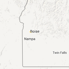
| 9:56 PM MDT | Quarter sized hail reported near Star, ID, 15.6 miles WNW of Boise, ID, largest hail 1.5 inches...smallest about a penny. average about the diameter of two fingers at floating feather rd and pollard ln. social media. |
Connect with Interactive Hail Maps