

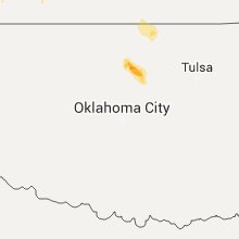
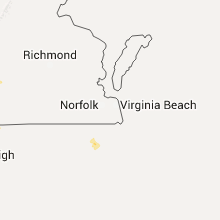
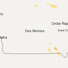
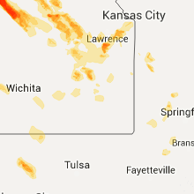
Hail Map for Thursday, September 10, 2015

Number of Impacted Households on 9/10/2015
0
Impacted by 1" or Larger Hail
0
Impacted by 1.75" or Larger Hail
0
Impacted by 2.5" or Larger Hail
Square Miles of Populated Area Impacted on 9/10/2015
0
Impacted by 1" or Larger Hail
0
Impacted by 1.75" or Larger Hail
0
Impacted by 2.5" or Larger Hail


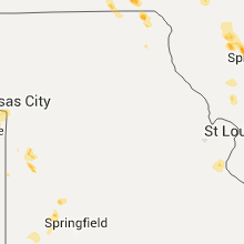


Cities Most Affected by Hail Storms of 9/10/2015
| Hail Size | Demographics of Zip Codes Affected | ||||||
|---|---|---|---|---|---|---|---|
| City | Count | Average | Largest | Pop Density | House Value | Income | Age |
| Randolph, KS | 2 | 4.00 | 4.00 | 4 | $67k | $38.0k | 45.6 |
| Linn, KS | 2 | 2.63 | 2.75 | 6 | $38k | $28.9k | 45.5 |
| Norton, KS | 2 | 2.25 | 2.75 | 10 | $55k | $31.1k | 42.6 |
| Haddam, KS | 2 | 2.25 | 2.75 | 2 | $15k | $25.3k | 52.6 |
| Munden, KS | 2 | 2.13 | 2.50 | 3 | $15k | $30.2k | 52.5 |
| Longford, KS | 2 | 1.75 | 1.75 | 3 | $20k | $27.0k | 44.3 |
| Chester, NE | 2 | 1.75 | 1.75 | 4 | $23k | $22.5k | 52.2 |
| Johnson, KS | 2 | 1.75 | 1.75 | 1 | $73k | $39.9k | 35.1 |
| Ottawa, KS | 2 | 1.75 | 1.75 | 96 | $73k | $37.4k | 35.8 |
| Almena, KS | 1 | 2.75 | 2.75 | 4 | $35k | $27.5k | 43.0 |
| Baldwin City, KS | 1 | 2.75 | 2.75 | 55 | $116k | $51.8k | 36.9 |
| Holbrook, NE | 1 | 2.50 | 2.50 | 2 | $20k | $25.9k | 45.4 |
| Miltonvale, KS | 1 | 2.50 | 2.50 | 4 | $26k | $26.7k | 43.2 |
| Lawrence, KS | 1 | 2.00 | 2.00 | 370 | $143k | $47.9k | 30.2 |
| Minneapolis, KS | 1 | 1.75 | 1.75 | 11 | $64k | $35.5k | 41.7 |
| Pleasant Plains, IL | 1 | 1.75 | 1.75 | 25 | $97k | $50.8k | 43.6 |
| Moulton, IA | 1 | 1.75 | 1.75 | 13 | $39k | $28.3k | 43.3 |
| Wakefield, KS | 1 | 1.75 | 1.75 | 10 | $70k | $35.0k | 38.7 |
| Great Bend, KS | 1 | 1.75 | 1.75 | 78 | $61k | $33.4k | 38.0 |
| Greenleaf, KS | 1 | 1.75 | 1.75 | 3 | $19k | $26.3k | 47.8 |
| Le Roy, KS | 1 | 1.75 | 1.75 | 9 | $42k | $32.6k | 45.8 |
| Tallula, IL | 1 | 1.75 | 1.75 | 8 | $69k | $41.6k | 44.4 |
| Bunker Hill, KS | 1 | 1.75 | 1.75 | 1 | $34k | $31.3k | 50.9 |
| Haven, KS | 1 | 1.75 | 1.75 | 17 | $74k | $41.5k | 38.7 |
Hail and Wind Damage Spotted on 9/10/2015
Filter by Report Type:Hail ReportsWind Reports
States Impacted
Iowa, Illinois, North Carolina, Georgia, Missouri, Kansas, Nebraska, South Carolina, Alabama, Oklahoma, TexasIowa
| Local Time | Report Details |
|---|---|
| 7:36 AM CDT | Quarter sized hail reported near Ventura, IA, 15.6 miles WSW of Mason City, IA, large amounts of quarter size hail |
| 8:31 PM CDT | Golf Ball sized hail reported near Moulton, IA, 51.2 miles WNW of Kahoka, MO, some crop damage as well. observer location moulton. |
| 8:43 PM CDT | Quarter sized hail reported near Bloomfield, IA, 46.2 miles WNW of Kahoka, MO, observer location bloomfield. |
| 8:56 PM CDT | Quarter sized hail reported near Cantril, IA, 19.3 miles NW of Kahoka, MO, reported hail was mostly nickel or smaller but a few stones were the size of quarters. |
Illinois
| Local Time | Report Details |
|---|---|
| 1:05 PM CDT | 6 inch diameter branch blown down. tin blown off a roo in marshall county IL, 31.2 miles NNE of Peoria, IL |
| 2:48 PM CDT | Relayed a public report of a trellis blown over and 2 to 4 inch limbs down in the yar in henderson county IL, 54.8 miles NE of Kahoka, MO |
| 5:22 PM CDT | Golf Ball sized hail reported near Tallula, IL, 54.1 miles SSW of Peoria, IL |
| 5:38 PM CDT | Golf Ball sized hail reported near Pleasant Plains, IL, 59.4 miles SSW of Peoria, IL |
| 8:23 PM CDT | Multiple large trees uproote in clinton county IL, 39.3 miles E of Saint Louis, MO |
| 8:39 PM CDT | 6-8 inch limbs down. steel flagpole bent at 45 degree angl in washington county IL, 37.3 miles ESE of Saint Louis, MO |
North Carolina
| Local Time | Report Details |
|---|---|
| 3:40 PM EDT | Quarter sized hail reported near Union Mills, NC, 58 miles NE of Greenville, SC |
| 3:45 PM EDT | Tree down along centennial roa in rutherford county NC, 58.7 miles NE of Greenville, SC |
| 5:18 PM EDT | 1 large tree down near newlin rd and old switchboard road time estimated by radar in alamance county NC, 41.8 miles W of Raleigh, NC |
| 5:19 PM EDT | Several reports of trees and powerlines down around tow in gaston county NC, 17.6 miles WNW of Charlotte, NC |
| 5:30 PM EDT | Several large trees down and trees down on power lines sparking a small woods fire in chatham county NC, 32.1 miles W of Raleigh, NC |
| 5:30 PM EDT | Large trees down along griffith stree in mecklenburg county NC, 19.2 miles N of Charlotte, NC |
| 5:44 PM EDT | Tree on a structure along airport roa in rowan county NC, 33.4 miles NNE of Charlotte, NC |
| 5:50 PM EDT | Tree down along branson road in cabarrus county NC, 17.8 miles NE of Charlotte, NC |
| 6:00 PM EDT | Tree down near byrd and faith road in rowan county NC, 34.2 miles NE of Charlotte, NC |
| 6:00 PM EDT | Tree down along centennial roa in rutherford county NC, 58.7 miles NE of Greenville, SC |
| 6:57 PM EDT | Tree down on shannon road in randolph county NC, 65.3 miles W of Raleigh, NC |
| 7:00 PM EDT | Tree down on eastwood drive in randolph county NC, 64.3 miles W of Raleigh, NC |
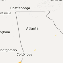
Georgia
| Local Time | Report Details |
|---|---|
| 3:54 PM EDT | Tree down on powerlines just south of us-84 bypas in decatur county GA, 34.6 miles NNW of Tallahassee, FL |
| 3:55 PM EDT | Quarter sized hail reported near Bainbridge, GA, 35.5 miles NNW of Tallahassee, FL, public report relayed by trained spotter of quarter size hail at walmart in bainbridge. |
| 5:45 PM EDT | Sheriff reported trees and power lines down on highway 23 near sardi in burke county GA, 37.2 miles SSE of Augusta, GA |
Missouri
| Local Time | Report Details |
|---|---|
| 2:55 PM CDT | A couple of downed trees on front street near highway z. one tree was 2.5 feet in diameter and fell ontu power lines. time estimated from rada in jefferson county MO, 27 miles SSW of Saint Louis, MO |
| 9:06 PM CDT | Tree limb snapped and fell onto power line in platte county MO, 8.5 miles NW of Kansas City, MO |
| 9:06 PM CDT | Half Dollar sized hail reported near Arbela, MO, 12.2 miles WNW of Kahoka, MO |
| 9:11 PM CDT | Tree limb fell onto power lines south of downtown kansas city in jackson county MO, 4.3 miles S of Kansas City, MO |
| 9:20 PM CDT | Estimated 60-65 mph winds at mile marker 6 on interstate 70 in jackson county MO, 5.5 miles E of Kansas City, MO |
| 9:24 PM CDT | Several reports from kc fire of tree limbs and power lines down...south and east of the downtown kc area in jackson county MO, 2.4 miles SE of Kansas City, MO |
| 9:26 PM CDT | Storm damage reported in clay county MO, 11.5 miles N of Kansas City, MO |
Kansas
| Local Time | Report Details |
|---|---|
| 4:20 PM CDT | Ping Pong Ball sized hail reported near Almena, KS, 73.2 miles NNW of Hays, KS, hail up to the size of ping pong. info passed through a spotter. |
| 4:30 PM CDT | Quarter sized hail reported near Phillipsburg, KS, 56.5 miles N of Hays, KS, hail up to quarter size |
| 4:40 PM CDT | Half Dollar sized hail reported near Phillipsburg, KS, 56 miles N of Hays, KS, pea to nickel size hail covering the ground. some were as big as quarters to half dollars. hail began about 20 minutes ago and small hail is still failing at 5 pm. wind |
| 4:58 PM CDT | Quarter sized hail reported near Logan, KS, 55.9 miles NNW of Hays, KS, pea to quarter size hail in logan. |
| 4:25 PM MDT | Quarter sized hail reported near Syracuse, KS, 60.3 miles WSW of Garden City, KS |
| 5:38 PM CDT | Quarter sized hail reported near Woodston, KS, 39.2 miles NNE of Hays, KS, copious amounts of hail covering ground...largest to around quarter size |
| 5:40 PM CDT | Quarter sized hail reported near Stockton, KS, 39.4 miles N of Hays, KS |
| 5:41 PM CDT | Roof totaled...cars totaled and all windows broken out of a residence 2 miles wsw of speed. no estimate on hail size or wind speed at the moment. hail and wind started in phillips county KS, 55.6 miles N of Hays, KS |
| 6:00 PM CDT | Ping Pong Ball sized hail reported near Haddam, KS, 57.2 miles NW of Manhattan, KS |
| 6:03 PM CDT | Grapefruit sized hail reported near Randolph, KS, 20.3 miles NNW of Manhattan, KS |
| 6:03 PM CDT | Ping Pong Ball sized hail reported near Washington, KS, 51.7 miles NW of Manhattan, KS, hail craked storm windows on the north side of house. estimated winds at least 50 mph. |
| 6:03 PM CDT | Golf Ball sized hail reported near Haddam, KS, 57.2 miles NW of Manhattan, KS |
| 6:05 PM CDT | Quarter sized hail reported near Plainville, KS, 24.8 miles N of Hays, KS |
| 6:06 PM CDT | Quarter sized hail reported near Munden, KS, 72.1 miles NW of Manhattan, KS, a few quarter size stones. no strong winds at the time. |
| 6:12 PM CDT | Tennis Ball sized hail reported near Munden, KS, 73.1 miles NW of Manhattan, KS |
| 6:12 PM CDT | Golf Ball sized hail reported near Munden, KS, 71.6 miles NW of Manhattan, KS, hail broke the storm door. |
| 6:15 PM CDT | Ping Pong Ball sized hail reported near Almena, KS, 75.3 miles NNW of Hays, KS |
| 6:18 PM CDT | Baseball sized hail reported near Almena, KS, 73.2 miles NNW of Hays, KS, baseball size hail lasted for about 5 minutes before decreasing to nickel size hail at time of call. |
| 6:18 PM CDT | Quarter sized hail reported near Manhattan, KS, 7 miles N of Manhattan, KS |
| 6:21 PM CDT | Baseball sized hail reported near Linn, KS, 46.7 miles NW of Manhattan, KS, at least one baseball size stone with 60-70mph estimated winds. |
| 6:21 PM CDT | Ping Pong Ball sized hail reported near Norton, KS, 65.1 miles ENE of Colby, KS, dime to ping pong size hail. hardly any wind/rain. |
| 6:21 PM CDT | Estimated wind gusts of 60-70mph with at least one baseball size stone. this lsr is along with previous hail ls in washington county KS, 46.7 miles NW of Manhattan, KS |
| 6:22 PM CDT | Half Dollar sized hail reported near Manhattan, KS, 0.4 miles W of Manhattan, KS |
| 6:25 PM CDT | Baseball sized hail reported near Norton, KS, 59 miles ENE of Colby, KS, golf ball to ping-pong ball size hail 5 minutes later. |
| 6:25 PM CDT | Ping Pong Ball sized hail reported near Manhattan, KS, 6.3 miles N of Manhattan, KS, a few ping pong size stones with 30mph wind. |
| 6:30 PM CDT | Golf Ball sized hail reported near Johnson, KS, 58.1 miles WSW of Garden City, KS |
| 6:33 PM CDT | Ping Pong Ball sized hail reported near Prairie View, KS, 67.4 miles N of Hays, KS, hail started around 633 pm and lasted roughly 5 minutes. |
| 6:35 PM CDT | Tennis Ball sized hail reported near Linn, KS, 41.4 miles NW of Manhattan, KS, tennis ball hail estimated. wind was not more than 30mph. |
| 6:38 PM CDT | Quarter sized hail reported near Johnson, KS, 55.3 miles WSW of Garden City, KS |
| 6:40 PM CDT | Golf Ball sized hail reported near Greenleaf, KS, 34.6 miles NW of Manhattan, KS |
| 6:40 PM CDT | Baseball sized hail reported near Haddam, KS, 58.8 miles NW of Manhattan, KS |
| 6:40 PM CDT | Storm damage reported in washington county KS, 58.8 miles NW of Manhattan, KS |
| 6:42 PM CDT | Golf Ball sized hail reported near Norton, KS, 63.9 miles NNW of Hays, KS |
| 6:42 PM CDT | Tree limbs up to five inches in diameter were blown dow in ness county KS, 42.4 miles WSW of Hays, KS |
| 6:43 PM CDT | Wind measured with davis instrument. golf ball size hail broke his windshiel in jewell county KS, 72.8 miles S of Grand Island, NE |
| 6:50 PM CDT | Quarter sized hail reported near Arnold, KS, 42.4 miles WSW of Hays, KS |
| 6:51 PM CDT | Quarter sized hail reported near Wamego, KS, 9.1 miles ENE of Manhattan, KS, law enforcement reported quarter inch size hail. |
| 6:54 PM CDT | Golf Ball sized hail reported near Bunker Hill, KS, 32 miles E of Hays, KS, trained spotter relayed via amatur radio. |
| 6:55 PM CDT | Quarter sized hail reported near Mankato, KS, 78.6 miles S of Grand Island, NE |
| 6:55 PM CDT | Storm damage reported in grant county KS, 40.7 miles SW of Garden City, KS |
| 6:56 PM CDT | Storm damage reported in jewell county KS, 82.9 miles NE of Hays, KS |
| 7:01 PM CDT | Ping Pong Ball sized hail reported near Randolph, KS, 20.3 miles NNW of Manhattan, KS |
| 7:03 PM CDT | Grapefruit sized hail reported near Randolph, KS, 20.3 miles NNW of Manhattan, KS |
| 7:05 PM CDT | Quarter sized hail reported near Linn, KS, 46.7 miles NW of Manhattan, KS |
| 7:05 PM CDT | Golf Ball sized hail reported near Johnson, KS, 57.2 miles WSW of Garden City, KS, hail accumulated to a depth of more than four inches. three inches of rain fell... as well... resulting in local flooding. |
| 7:10 PM CDT | Half Dollar sized hail reported near Wamego, KS, 14.4 miles ENE of Manhattan, KS |
| 7:10 PM CDT | Golf Ball sized hail reported near Le Roy, KS, 28 miles NNW of Chanute, KS, a couple golf ball stones seen. |
| 7:20 PM CDT | Quarter sized hail reported near Manter, KS, 69.2 miles WSW of Garden City, KS |
| 7:20 PM CDT | Golf Ball sized hail reported near Longford, KS, 35.9 miles W of Manhattan, KS |
| 7:20 PM CDT | Quarter sized hail reported near Ottawa, KS, 51.2 miles SW of Kansas City, MO, 35-45 mph wind gusts with the hail. |
| 7:23 PM CDT | Ping Pong Ball sized hail reported near Jamestown, KS, 73.9 miles WNW of Manhattan, KS, lots of ping pong size hail with 40-45mph wind gusts. |
| 7:23 PM CDT | Golf Ball sized hail reported near Longford, KS, 35.9 miles W of Manhattan, KS, a few golf ball size stones with 60mph wind gusts |
| 7:26 PM CDT | Quarter sized hail reported near Le Roy, KS, 29.1 miles NNW of Chanute, KS |
| 7:27 PM CDT | Power lines reported downe in franklin county KS, 49.8 miles SW of Kansas City, MO |
| 7:28 PM CDT | Golf Ball sized hail reported near Ottawa, KS, 47.6 miles SW of Kansas City, MO |
| 7:28 PM CDT | Golf Ball sized hail reported near Wakefield, KS, 30 miles W of Manhattan, KS, a few golf ball size stones. |
| 7:28 PM CDT | Golf Ball sized hail reported near Ottawa, KS, 51.7 miles SW of Kansas City, MO, measured with ruler by spotter |
| 7:30 PM CDT | Ping Pong Ball sized hail reported near Hays, KS, 0.9 miles NE of Hays, KS |
| 7:30 PM CDT | Quarter sized hail reported near Wamego, KS, 13.6 miles E of Manhattan, KS |
| 7:31 PM CDT | Storm damage reported in stanton county KS, 59.1 miles SW of Garden City, KS |
| 7:36 PM CDT | Ping Pong Ball sized hail reported near Wamego, KS, 15.1 miles E of Manhattan, KS |
| 7:37 PM CDT | Baseball sized hail reported near Baldwin City, KS, 46.9 miles WSW of Kansas City, MO |
| 7:40 PM CDT | Quarter sized hail reported near Johnson, KS, 62.5 miles SW of Garden City, KS |
| 7:45 PM CDT | Half Dollar sized hail reported near Westmoreland, KS, 16.7 miles NNE of Manhattan, KS |
| 7:52 PM CDT | Tennis Ball sized hail reported near Miltonvale, KS, 53.1 miles W of Manhattan, KS |
| 7:53 PM CDT | Storm damage reported in geary county KS, 17.9 miles WSW of Manhattan, KS |
| 7:53 PM CDT | Quarter sized hail reported near Milford, KS, 17.9 miles WSW of Manhattan, KS |
| 7:53 PM CDT | Golf Ball sized hail reported near Minneapolis, KS, 47.8 miles W of Manhattan, KS, several golf ball hail stones and 40 mph winds estimated |
| 7:54 PM CDT | Quarter sized hail reported near Baldwin City, KS, 39.6 miles SW of Kansas City, MO |
| 7:59 PM CDT | Unofficial mesonet report. site identifier qnrk1. winds was also reported as 49 mph sustaine in stafford county KS, 67 miles SE of Hays, KS |
| 8:00 PM CDT | Quarter sized hail reported near Overbrook, KS, 50.3 miles WSW of Kansas City, MO |
| 8:00 PM CDT | Half Dollar sized hail reported near Olathe, KS, 22.9 miles SW of Kansas City, MO |
| 8:05 PM CDT | Quarter sized hail reported near Maple Hill, KS, 27.6 miles ESE of Manhattan, KS |
| 8:06 PM CDT | Storm damage reported in stevens county KS, 47.6 miles SSW of Garden City, KS |
| 8:08 PM CDT | Storm damage reported in geary county KS, 13.4 miles SW of Manhattan, KS |
| 8:08 PM CDT | Hen Egg sized hail reported near Lawrence, KS, 44.3 miles WSW of Kansas City, MO |
| 8:10 PM CDT | Ping Pong Ball sized hail reported near Lawrence, KS, 45.4 miles WSW of Kansas City, MO, quarter size to a few ping pong size hail stones fell. |
| 8:11 PM CDT | Quarter sized hail reported near Bushton, KS, 55.9 miles ESE of Hays, KS, nickel to quarter size hail. |
| 8:15 PM CDT | Quarter sized hail reported near Jetmore, KS, 52.1 miles ENE of Garden City, KS |
| 8:15 PM CDT | Ping Pong Ball sized hail reported near Alma, KS, 13.6 miles ESE of Manhattan, KS |
| 8:18 PM CDT | Quarter sized hail reported near De Soto, KS, 22.5 miles WSW of Kansas City, MO, reported by deputy at lexington and commerce dr. |
| 8:19 PM CDT | Trained spotter reported multiple 3 to 4 inch tree limbs down along with large trees around the great bend area. time radar estimate in barton county KS, 45.2 miles SE of Hays, KS |
| 8:19 PM CDT | Estimated 65 to 70 mph winds with pea to dime size hai in barton county KS, 45.2 miles SE of Hays, KS |
| 8:19 PM CDT | Roof damage to a nursing home on the north side of tow in barton county KS, 44.1 miles SE of Hays, KS |
| 8:19 PM CDT | 80 percent of the roof was blown off the gymnasium of lincoln elementar in barton county KS, 44.5 miles SE of Hays, KS |
| 8:20 PM CDT | Multiple reports of power outages across great bend. power poles and trees down across the city as wel in barton county KS, 45.2 miles SE of Hays, KS |
| 8:22 PM CDT | Tree limbs down along with quarter size hai in barton county KS, 47.6 miles SE of Hays, KS |
| 8:22 PM CDT | Half Dollar sized hail reported near Great Bend, KS, 47.6 miles SE of Hays, KS, quarter to half dollar size hail. |
| 8:25 PM CDT | Measured at barton county landfill from a davis weather statio in barton county KS, 45 miles SE of Hays, KS |
| 8:25 PM CDT | Golf Ball sized hail reported near Great Bend, KS, 47.3 miles SE of Hays, KS, described as golf ball or larger. storm chaster lost windshield with estimated wind of 70+ mph |
| 8:25 PM CDT | Storm damage reported in morton county KS, 84 miles SW of Garden City, KS |
| 8:26 PM CDT | Storm damage reported in dickinson county KS, 37.7 miles WSW of Manhattan, KS |
| 8:29 PM CDT | Quarter sized hail reported near Olathe, KS, 18.9 miles SW of Kansas City, MO, report via mping |
| 8:34 PM CDT | Quarter sized hail reported near Carbondale, KS, 45.1 miles ESE of Manhattan, KS, saw a broken wall cloud pass about 2 miles east. did not see a funnel. |
| 8:35 PM CDT | Quarter sized hail reported near Alma, KS, 29.4 miles SE of Manhattan, KS, estimated wind with hail was about 50mph. |
| 8:35 PM CDT | Tree 2ft diameter blocking road at 66th and monticello in johnson county KS, 14.7 miles WSW of Kansas City, MO |
| 8:47 PM CDT | Storm damage reported in lyon county KS, 41 miles SSE of Manhattan, KS |
| 8:47 PM CDT | Storm damage reported in lyon county KS, 46.6 miles SE of Manhattan, KS |
| 8:50 PM CDT | Storm damage reported in leavenworth county KS, 19.2 miles W of Kansas City, MO |
| 8:52 PM CDT | Reported downed tree limbs as well... but size unknown at this tim in lyon county KS, 41 miles SSE of Manhattan, KS |
| 8:59 PM CDT | Unofficial mesonet report. site identifier qnrk1. winds was also reported as 49 mph sustaine in stafford county KS, 67 miles SE of Hays, KS |
| 9:05 PM CDT | Dime size hail with wind gusts. no damag in geary county KS, 14.7 miles SW of Manhattan, KS |
| 9:13 PM CDT | Reports of power lines down in abbyville. time radar estimate in reno county KS, 51.2 miles WNW of Wichita, KS |
| 9:15 PM CDT | 6 to 10 inch diameter tree limbs downed around the court hous in morris county KS, 36 miles S of Manhattan, KS |
| 9:21 PM CDT | 4 inch diameter tree limbs downe in morris county KS, 37.2 miles S of Manhattan, KS |
| 9:23 PM CDT | Storm damage reported in lyon county KS, 38.2 miles SSE of Manhattan, KS |
| 9:25 PM CDT | Power outages reported in arlingto in reno county KS, 48.5 miles WNW of Wichita, KS |
| 9:31 PM CDT | Trained spotters estimate 50 to 60 mph winds. relayed via emergency managemen in reno county KS, 38 miles W of Wichita, KS |
| 9:50 PM CDT | Emergency management estimated winds just north of town about 1 mil in anderson county KS, 44.2 miles NNE of Chanute, KS |
| 9:50 PM CDT | Semi truck rolled off the roa in sedgwick county KS, 24.6 miles W of Wichita, KS |
| 9:55 PM CDT | Emergency management reported 70mph gust in franklin county KS, 50.7 miles NNE of Chanute, KS |
| 9:56 PM CDT | Golf Ball sized hail reported near Haven, KS, 28.4 miles WNW of Wichita, KS, haven police department reported golf ball size hail. |
| 10:14 PM CDT | Storm damage reported in miami county KS, 39.3 miles SSW of Kansas City, MO |
| 10:15 PM CDT | Storm damage reported in johnson county KS, 32.6 miles SW of Kansas City, MO |
| 10:15 PM CDT | 8 to 10 inch diameter tree down...winds estimated 50 to 60 mph. time estimated by rada in linn county KS, 48.9 miles NNE of Chanute, KS |
| 10:35 PM CDT | Storm damage reported in allen county KS, 17.3 miles N of Chanute, KS |
Nebraska
| Local Time | Report Details |
|---|---|
| 4:25 PM CDT | Half Dollar sized hail reported near Lawrence, NE, 49.7 miles S of Grand Island, NE, hail up to half dollar size and heavy rain. |
| 4:30 PM CDT | Quarter sized hail reported near Lexington, NE, 56.5 miles ESE of North Platte, NE, trained spotter reported hail from pea to quarter size. |
| 5:08 PM CDT | Ping Pong Ball sized hail reported near Carleton, NE, 54.4 miles SE of Grand Island, NE, hailed from approx. 508-518 pm...largest ping pong ball |
| 5:25 PM CDT | Quarter sized hail reported near Bruning, NE, 58.5 miles SE of Grand Island, NE, hail up to quarter size. |
| 5:27 PM CDT | Tennis Ball sized hail reported near Holbrook, NE, 70.2 miles SSE of North Platte, NE |
| 5:33 PM CDT | Ping Pong Ball sized hail reported near Deshler, NE, 65.6 miles SSE of Grand Island, NE, a few up to ping pong ball size |
| 5:47 PM CDT | Quarter sized hail reported near Chester, NE, 73.6 miles SSE of Grand Island, NE |
| 5:51 PM CDT | Half Dollar sized hail reported near Beaver City, NE, 82.5 miles NE of Colby, KS, dime to half dollar size hail falling right now. |
| 5:51 PM CDT | Half Dollar sized hail reported near Chester, NE, 73.6 miles SSE of Grand Island, NE, public report of half dollar size hail in chester. relayed by nws omaha office. |
| 5:52 PM CDT | Golf Ball sized hail reported near Chester, NE, 73.6 miles SSE of Grand Island, NE, dime to golf ball size hail now falling in chester. |
| 6:00 PM CDT | Golf Ball sized hail reported near Chester, NE, 73.6 miles SSE of Grand Island, NE, golf ball size hail in chester broke the back window of a car. |
| 6:03 PM CDT | Storm damage reported in webster county NE, 53.8 miles SSW of Grand Island, NE |
| 6:05 PM CDT | Storm damage reported in webster county NE, 54.7 miles S of Grand Island, NE |
| 6:58 PM CDT | Quarter sized hail reported near Byron, NE, 69.9 miles SSE of Grand Island, NE, hail from marble to quarter size with 70 mph winds. |
South Carolina
| Local Time | Report Details |
|---|---|
| 5:28 PM EDT | Lancaster county 911 reported straight-line wind damage... including an awning on adam lane... a downed tree on king mill road... and power lines down on flat creek road in lancaster county SC, 36 miles S of Charlotte, NC |
| 5:28 PM EDT | Lancaster county 911 reported a large car port-shed blown down on fairfield street in the city of lancaste in lancaster county SC, 35 miles S of Charlotte, NC |
| 5:38 PM EDT | Lancaster county 911 reported a large car port-shed blown down on pageland hwy... and a tree fallen onto a house on fairfield street in the city of lancaste in lancaster county SC, 35 miles S of Charlotte, NC |
| 6:00 PM EDT | Srs wind tower at k area measured a 59 mph wind gust. note: tower is 200 feet above the groun in barnwell county SC, 26 miles SE of Augusta, GA |
| 6:00 PM EDT | Srs wind tower at n area measured a 78 mph wind gust. note: tower is 200 feet above the groun in barnwell county SC, 24.6 miles SE of Augusta, GA |
| 7:30 PM EDT | Trees down on pudding swamp rd. time estimated in clarendon county SC, 45.8 miles N of Charleston, SC |
| 7:35 PM EDT | Tree down at dantzler lane and hendersonville hwy. time estimate in colleton county SC, 46 miles WSW of Charleston, SC |
| 7:40 PM EDT | Trees down on power lines along highway 311. time estimated based on rada in berkeley county SC, 14.4 miles WNW of Charleston, SC |
| 7:45 PM EDT | Tree down at merrick drive at cottageville hwy. time estimate in colleton county SC, 36.3 miles WSW of Charleston, SC |
| 7:55 PM EDT | Trees down on patriot rd and hwy 260. time estimate in clarendon county SC, 26 miles NNW of Charleston, SC |
| 7:55 PM EDT | Trees down on greeleyville hwy near foreston hwy. time estimated in clarendon county SC, 30.7 miles N of Charleston, SC |
| 7:58 PM EDT | Trees down at russelville road and highway 3 in berkeley county SC, 14.2 miles N of Charleston, SC |
| 8:15 PM EDT | 10 inch diameter tree trunk snapped near st james ave and central ave in berkeley county SC, 12.9 miles S of Charleston, SC |
| 8:18 PM EDT | Former nws employee reported wind gust to 60 mph with several branches broke in charleston county SC, 17.7 miles S of Charleston, SC |
| 8:20 PM EDT | Power poles were reported down along u.s. 52 in williamsburg county SC, 28.3 miles NNE of Charleston, SC |
| 8:25 PM EDT | A tree was reported in the roadway at the intersection of taft road and mabel lane. time estimated based on radar dat in williamsburg county SC, 26.9 miles NNE of Charleston, SC |
| 8:25 PM EDT | Tree down at sandy drive and hill st. time estimated by radar and schp repor in berkeley county SC, 0.9 miles N of Charleston, SC |
| 8:30 PM EDT | Tree down at cane gulley rd and bullhead rd. time estimated by radar and schp repor in berkeley county SC, 5.5 miles E of Charleston, SC |
| 8:45 PM EDT | Mount pleasant pd reported a tree on a power line at king st and lonnie circle. time estimate in charleston county SC, 29.4 miles SSE of Charleston, SC |
| 8:45 PM EDT | Tree down at merrick drive at cottageville hwy. time estimate in colleton county SC, 36.3 miles WSW of Charleston, SC |
| 9:05 PM EDT | A tree was reported down on u.s. 521. the time was estimated based on radar dat in georgetown county SC, 37.1 miles ENE of Charleston, SC |
Alabama
| Local Time | Report Details |
|---|---|
| 5:43 PM CDT | Power pole broken in the rehobeth area resulting in a power outage in houston county AL, 75.5 miles NE of Miramar Beach, FL |
| 5:45 PM CDT | A few trees reported down around columbi in houston county AL, 76.5 miles NW of Tallahassee, FL |
| 5:55 PM CDT | Trees down on power lines in the cummings circle area resulting in power outages in houston county AL, 78.3 miles NW of Tallahassee, FL |
| 5:57 PM CDT | A few trees reported down near lovetow in houston county AL, 75.7 miles NW of Tallahassee, FL |
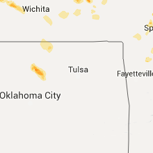
Oklahoma
| Local Time | Report Details |
|---|---|
| 9:30 PM CDT | Storm damage reported in texas county OK, 96.9 miles N of Amarillo, TX |
| 1:30 AM CDT | Storm damage reported in logan county OK, 43.5 miles N of Oklahoma City, OK |
| 6:48 AM UTC | Storm damage reported in payne county OK, 53.5 miles NNE of Oklahoma City, OK |
Texas
| Local Time | Report Details |
|---|---|
| 10:35 PM CDT | Storm damage reported in ochiltree county TX, 75.3 miles W of Woodward, OK |
Connect with Interactive Hail Maps