

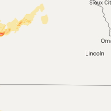
Hail Map for Sunday, September 4, 2016

Number of Impacted Households on 9/4/2016
0
Impacted by 1" or Larger Hail
0
Impacted by 1.75" or Larger Hail
0
Impacted by 2.5" or Larger Hail
Square Miles of Populated Area Impacted on 9/4/2016
0
Impacted by 1" or Larger Hail
0
Impacted by 1.75" or Larger Hail
0
Impacted by 2.5" or Larger Hail


Cities Most Affected by Hail Storms of 9/4/2016
| Hail Size | Demographics of Zip Codes Affected | ||||||
|---|---|---|---|---|---|---|---|
| City | Count | Average | Largest | Pop Density | House Value | Income | Age |
| Bridgeport, NE | 5 | 2.75 | 3.00 | 2 | $50k | $30.3k | 42.9 |
| Wray, CO | 2 | 2.75 | 3.00 | 5 | $72k | $33.4k | 39.1 |
| Kimball, NE | 2 | 1.75 | 1.75 | 7 | $54k | $30.6k | 45.6 |
| Hillrose, CO | 1 | 1.75 | 1.75 | 13 | $81k | $30.0k | 42.5 |
| Big Springs, NE | 1 | 1.75 | 1.75 | 2 | $47k | $29.3k | 49.5 |
| Mound City, SD | 1 | 1.75 | 1.75 | 1 | $12k | $35.0k | 51.8 |
| Leoti, KS | 1 | 1.75 | 1.75 | 2 | $56k | $33.3k | 39.7 |
| Idalia, CO | 1 | 1.75 | 1.75 | 1 | $119k | $36.3k | 34.9 |
| Holyoke, CO | 1 | 1.75 | 1.75 | 6 | $81k | $32.1k | 41.5 |
| Julesburg, CO | 1 | 1.75 | 1.75 | 6 | $62k | $28.8k | 48.8 |
Hail and Wind Damage Spotted on 9/4/2016
Filter by Report Type:Hail ReportsWind Reports
North Dakota
| Local Time | Report Details |
|---|---|
| 7:15 AM CDT | Spotted a pole leaning over on highway 94 between sweet briar lake and new salem in morton county ND, 30.1 miles W of Bismarck, ND |
| 8:15 AM CDT | Public reported that five power poles were broken near mile marker 5 on highway 36 east of wilton... and a blade was ripped off a wind turbine in the area. several larg in burleigh county ND, 24.9 miles N of Bismarck, ND |
| 9:20 AM CDT | Quarter sized hail reported near Buchanan, ND, 72.7 miles S of Devils Lake, ND |
Wyoming
| Local Time | Report Details |
|---|---|
| 12:55 PM MDT | Quarter sized hail reported near Bondurant, WY, 84.7 miles ESE of Idaho Falls, ID, public report relayed through em |
| 4:58 PM MDT | Rock springs airport /rks in sweetwater county WY, 8.4 miles E of Rock Springs, WY |
| 5:56 PM MDT | Sustained wind 33 mph from the northwes in converse county WY, 23.8 miles E of Casper, WY |
Texas
| Local Time | Report Details |
|---|---|
| 1:55 PM CDT | Telephone pole blown down on fm 1015 in town of lasar in willacy county TX, 46.4 miles NNW of Brownsville, TX |
| 1:55 PM CDT | Power line down in raymondville near intersection of tx 186 and bus 7 in willacy county TX, 43.7 miles NNW of Brownsville, TX |
Colorado
| Local Time | Report Details |
|---|---|
| 1:08 PM MDT | Storm damage reported in prowers county CO, 99.4 miles W of Garden City, KS |
| 1:59 PM MDT | Storm damage reported in kiowa county CO, 77.1 miles WNW of Garden City, KS |
| 3:15 PM MDT | Golf Ball sized hail reported near Idalia, CO, 39.3 miles SE of Yuma, CO |
| 4:10 PM MDT | Tennis Ball sized hail reported near Wray, CO, 37.7 miles ENE of Yuma, CO |
| 4:13 PM MDT | Tea Cup sized hail reported near Wray, CO, 37.6 miles NE of Yuma, CO, social media report. image posted of hailstone and tape measure. |
| 4:24 PM MDT | Golf Ball sized hail reported near Holyoke, CO, 38.2 miles NE of Yuma, CO |
| 5:02 PM MDT | Golf Ball sized hail reported near Julesburg, CO, 60.8 miles NNE of Yuma, CO, house windows broken with hail in the house |
| 5:21 PM MDT | Quarter sized hail reported near Brush, CO, 44.6 miles WNW of Yuma, CO |
| 5:30 PM MDT | Golf Ball sized hail reported near Hillrose, CO, 45.1 miles WNW of Yuma, CO |
| 6:00 PM MDT | Power pole down along with 3 feet diameter tree down in wile in prowers county CO, 101.6 miles W of Garden City, KS |
South Dakota
| Local Time | Report Details |
|---|---|
| 2:45 PM MDT | Quarter sized hail reported near Pine Ridge, SD, 81.8 miles SSE of Rapid City, SD, lasted 10 to 15 minutes |
| 3:24 PM MDT | Quarter sized hail reported near Wanblee, SD, 72 miles NW of Valentine, NE |
| 3:45 PM MDT | Storm damage reported in bennett county SD, 73.5 miles WNW of Valentine, NE |
| 5:28 PM CDT | Storm damage reported in mellette county SD, 55.2 miles NNW of Valentine, NE |
| 5:55 PM CDT | Storm damage reported in mellette county SD, 51.6 miles SSW of Pierre, SD |
| 5:01 PM MDT | Quarter sized hail reported near Fort Pierre, SD, 5.2 miles WNW of Pierre, SD, hail of various sizes including quarter sized. |
| 5:10 PM MDT | Storm damage reported in oglala lakota county SD, 71.1 miles SSE of Rapid City, SD |
| 6:31 PM CDT | Storm damage reported in jones county SD, 43.5 miles S of Pierre, SD |
| 6:01 PM MDT | Storm damage reported in oglala lakota county SD, 81.9 miles W of Valentine, NE |
| 6:40 PM MDT | Storm damage reported in bennett county SD, 59.6 miles WNW of Valentine, NE |
| 7:56 PM CDT | Golf Ball sized hail reported near Mound City, SD, 74.4 miles WNW of Aberdeen, SD, . |
| 7:58 PM CDT | Storm damage reported in todd county SD, 41 miles NW of Valentine, NE |
| 6:58 PM MDT | Storm damage reported in jackson county SD, 69.1 miles NW of Valentine, NE |
| 7:50 PM MDT | Storm damage reported in haakon county SD, 44 miles WSW of Pierre, SD |
| 12:15 AM CDT | Trees down and some property damage. extent of damage unknown at this time. report time based on rada in bon homme county SD, 47.6 miles NE of Oneill, NE |
| 12:45 AM CDT | Storm damage reported in yankton county SD, 54.7 miles SW of Sioux Falls, SD |
Kansas
| Local Time | Report Details |
|---|---|
| 3:13 PM MDT | Estimated 60 mph winds with dime sized hail in greeley county KS, 58.9 miles NW of Garden City, KS |
| 3:55 PM MDT | Storm damage reported in sherman county KS, 35.2 miles W of Colby, KS |
| 5:26 PM CDT | Golf Ball sized hail reported near Leoti, KS, 54.2 miles NNW of Garden City, KS |
| 5:29 PM CDT | Ping Pong Ball sized hail reported near Leoti, KS, 53.6 miles NNW of Garden City, KS |
| 6:43 PM CDT | Quarter sized hail reported near Winona, KS, 37.3 miles S of Colby, KS |
| 7:15 PM CDT | Quarter sized hail reported near Oakley, KS, 23.5 miles SSE of Colby, KS |
| 8:06 PM CDT | Quarter sized hail reported near Oakley, KS, 23.5 miles SSE of Colby, KS |
| 7:30 PM MDT | 3 or 4 power poles down. time estimated by rada in greeley county KS, 58.1 miles NW of Garden City, KS |
Nebraska
| Local Time | Report Details |
|---|---|
| 3:41 PM MDT | Golf Ball sized hail reported near Kimball, NE, 43.6 miles S of Scottsbluff, NE |
| 3:45 PM MDT | Golf Ball sized hail reported near Kimball, NE, 40.3 miles S of Scottsbluff, NE, golfball hail reported at intersection of hwy 44 and hwy 49. |
| 3:45 PM MDT | Baseball sized hail reported near Bridgeport, NE, 35 miles ESE of Scottsbluff, NE, report relayed by kneb radio. |
| 3:50 PM MDT | Quarter sized hail reported near Bayard, NE, 14.3 miles SE of Scottsbluff, NE |
| 3:52 PM MDT | Tennis Ball sized hail reported near Bridgeport, NE, 30.4 miles SE of Scottsbluff, NE, 2 to 3 inch diameter hail reported. |
| 3:55 PM MDT | Tennis Ball sized hail reported near Bridgeport, NE, 32.9 miles SE of Scottsbluff, NE |
| 4:57 PM MDT | Quarter sized hail reported near Broadwater, NE, 46 miles ESE of Scottsbluff, NE |
| 5:00 PM MDT | Tea Cup sized hail reported near Bridgeport, NE, 37.5 miles ESE of Scottsbluff, NE |
| 5:00 PM MDT | Tea Cup sized hail reported near Bridgeport, NE, 30.4 miles SE of Scottsbluff, NE |
| 5:15 PM MDT | Golf Ball sized hail reported near Big Springs, NE, 66.2 miles W of North Platte, NE, hail to quarter size with an occasional golf ball. wind speed est 60 mph |
| 5:15 PM MDT | Mesonet observation from near big springs...up938 at 515 pm md in keith county NE, 65.8 miles W of North Platte, NE |
| 5:16 PM MDT | Half Dollar sized hail reported near Chadron, NE, 85.3 miles SSE of Rapid City, SD, in addition to hail...winds were estimated at 30-40 mph |
| 5:22 PM MDT | King canyon raws in dawes county NE, 70.1 miles NNE of Scottsbluff, NE |
| 5:25 PM MDT | Half Dollar sized hail reported near Chadron, NE, 85.3 miles SSE of Rapid City, SD, in addition to hail...winds were estimated at 30-40 mph |
| 5:25 PM MDT | Est 60 mph winds with large hail possibly to quarter size. over one inch of rain with water covering the road in keith county NE, 62.2 miles W of North Platte, NE |
| 5:31 PM MDT | Quarter sized hail reported near Gordon, NE, 88.8 miles SSE of Rapid City, SD |
| 6:00 PM MDT | Storm damage reported in arthur county NE, 61.9 miles NW of North Platte, NE |
| 6:35 PM MDT | Trees bending over with small limbs broken off in grant county NE, 68.3 miles NNW of North Platte, NE |
| 8:45 PM CDT | Trees bending over from the wind. pea size hail also reported in mcpherson county NE, 30.2 miles NNW of North Platte, NE |
| 9:13 PM CDT | Half Dollar sized hail reported near Stapleton, NE, 29.6 miles NNE of North Platte, NE |
| 9:20 PM CDT | Ping Pong Ball sized hail reported near Sutherland, NE, 34.5 miles NW of North Platte, NE, 50 mph winds also reported |
Minnesota
| Local Time | Report Details |
|---|---|
| 2:19 AM CDT | Storm damage reported in cottonwood county MN, 78 miles SSE of Montevideo, MN |
Connect with Interactive Hail Maps