

Hail Map for Friday, September 7, 2012

Number of Impacted Households on 9/7/2012
0
Impacted by 1" or Larger Hail
0
Impacted by 1.75" or Larger Hail
0
Impacted by 2.5" or Larger Hail
Square Miles of Populated Area Impacted on 9/7/2012
0
Impacted by 1" or Larger Hail
0
Impacted by 1.75" or Larger Hail
0
Impacted by 2.5" or Larger Hail


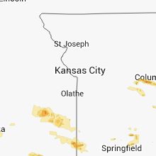


Cities Most Affected by Hail Storms of 9/7/2012
| Hail Size | Demographics of Zip Codes Affected | ||||||
|---|---|---|---|---|---|---|---|
| City | Count | Average | Largest | Pop Density | House Value | Income | Age |
| Columbia, MO | 9 | 2.00 | 2.75 | 469 | $107k | $30.5k | 25.1 |
| Dover, AR | 3 | 2.08 | 2.75 | 28 | $65k | $31.9k | 41.0 |
| Wichita, KS | 2 | 2.13 | 2.50 | 2804 | $96k | $43.3k | 31.1 |
| Jefferson City, MO | 2 | 1.75 | 1.75 | 475 | $99k | $45.0k | 38.2 |
| Warrenton, MO | 1 | 2.50 | 2.50 | 99 | $104k | $37.1k | 39.0 |
| Caney, KS | 1 | 2.00 | 2.00 | 57 | $45k | $33.1k | 39.6 |
| Troy, MO | 1 | 1.75 | 1.75 | 181 | $111k | $44.2k | 34.3 |
| Elizabethtown, IL | 1 | 1.75 | 1.75 | 13 | $55k | $24.8k | 47.1 |
Hail and Wind Damage Spotted on 9/7/2012
Filter by Report Type:Hail ReportsWind Reports
States Impacted
Arkansas, Illinois, Indiana, Ohio, Kansas, Pennsylvania, Missouri, Oklahoma, New Jersey, Florida, Arizona, Massachusetts, New York, Georgia, Kentucky, Tennessee, MississippiArkansas
| Local Time | Report Details |
|---|---|
| 7:50 AM CDT | Three hangers destroyed and three planes were damaged at the batesville airport. winds were estimated at 80 mp in independence county AR, 79.5 miles NNE of Little Rock, AR |
| 7:50 AM CDT | Three cars were crushed by falling trees and two houses were damaged by trees faling on them in the desha community. numerous large trees also in independence county AR, 75.5 miles NNE of Little Rock, AR |
| 2:05 PM CDT | Wind damage near intersection of wagon wheel road and thompson road...old hwy 71. power lines down. tin in trees. double wide mobile home roof remove in benton county AR, 60.5 miles NNE of Fort Smith, AR |
| 2:10 PM CDT | Spring valley subdivision is not near goshen but is south of lowell...off of ferns valley loop just east of wagon wheel and hwy 71b. damage in spring valley subdivision in benton county AR, 59.7 miles NNE of Fort Smith, AR |
| 2:20 PM CDT | Damage in spring valley subdivision. damage to roofs...fences and trees in the are in washington county AR, 55 miles NNE of Fort Smith, AR |
| 2:45 PM CDT | Quarter sized hail reported near Midway, AR, 72.9 miles SE of Springfield, MO |
| 3:12 PM CDT | Half Dollar sized hail reported near Mountain Home, AR, 77.1 miles SE of Springfield, MO |
| 3:58 PM CDT | Tree reported dow in sharp county AR, 91.5 miles S of Salem, MO |
| 4:00 PM CDT | Trees were blown down in mountain home...and other parts of the count in baxter county AR, 78.4 miles SE of Springfield, MO |
| 4:45 PM CDT | Limbs were blown dow in sharp county AR, 102.5 miles S of Salem, MO |
| 5:15 PM CDT | Large section of privacy fence blown ove in benton county AR, 67.3 miles NNE of Fort Smith, AR |
| 5:23 PM CDT | Storm damage reported in washington county AR, 48.3 miles NNE of Fort Smith, AR |
| 5:28 PM CDT | 2 large oak trees down on college avenu in washington county AR, 48.8 miles NNE of Fort Smith, AR |
| 5:29 PM CDT | Measured in the stonebridge meadows subdivision in fayetteville with a home weather statio in washington county AR, 48.8 miles NNE of Fort Smith, AR |
| 5:30 PM CDT | Power lines reported down in south fayettevill in washington county AR, 48.8 miles NNE of Fort Smith, AR |
| 5:40 PM CDT | Between elkins and durham along highway 1 in washington county AR, 46.5 miles NNE of Fort Smith, AR |
| 5:42 PM CDT | Estimated 70 mph winds. trees down and power ou in madison county AR, 68.5 miles NNE of Fort Smith, AR |
| 5:45 PM CDT | Large tree limbs dow in washington county AR, 46.8 miles NNE of Fort Smith, AR |
| 5:45 PM CDT | Numerous trees damaged. some trees blow down. one shed destroyed by win in madison county AR, 60.9 miles NNE of Fort Smith, AR |
| 5:55 PM CDT | Many trees damaged and blown down. numerous roads were blocked by downed trees and tree limbs around berryville and sout in carroll county AR, 60.5 miles SSW of Springfield, MO |
| 5:55 PM CDT | Numerous trees damaged by wind. a few trees blown down blocking roads in huntsville are in madison county AR, 61.9 miles NE of Fort Smith, AR |
| 6:10 PM CDT | Numerous large tree limbs broken and down. a couple of trees blown down. estimated winds over 60 mp in madison county AR, 68.4 miles NE of Fort Smith, AR |
| 6:10 PM CDT | A tree was blown down near highway 62 and harmon roa in boone county AR, 70.3 miles SSE of Springfield, MO |
| 6:15 PM CDT | Thunderstorm wind gusts 55 to 60 mph at central mal in sebastian county AR, 1.3 miles ENE of Fort Smith, AR |
| 6:20 PM CDT | Large tree branches blown down. location on old greenwood roa in sebastian county AR, 1.3 miles ENE of Fort Smith, AR |
| 6:25 PM CDT | Numerous reports of power lines and trees down around jasper and also on highway 7 heading north out of jaspe in newton county AR, 81.6 miles ENE of Fort Smith, AR |
| 6:25 PM CDT | Trees were blown down in multiple areas along highway 7 in the ozark national fores in pope county AR, 71.2 miles NW of Little Rock, AR |
| 6:28 PM CDT | Metal roofing blown off roof at ft. chaffee military installation. relayed by wfo lz in franklin county AR, 23.4 miles ESE of Fort Smith, AR |
| 6:30 PM CDT | Trees and power lines were blown dow in pope county AR, 65.3 miles NW of Little Rock, AR |
| 6:30 PM CDT | Numerous trees and power lines down throughout sebastian county. many roads blocked from debri in sebastian county AR, 1.3 miles ENE of Fort Smith, AR |
| 6:30 PM CDT | Tree limbs down near cavanaugh and state line road. 7800 block of martin street more limbs down and power lines dow in sebastian county AR, 1.3 miles ENE of Fort Smith, AR |
| 6:30 PM CDT | Tree reported down on a powerlin in boone county AR, 64.5 miles SSE of Springfield, MO |
| 6:30 PM CDT | Golf Ball sized hail reported near Dover, AR, 65.3 miles NW of Little Rock, AR |
| 6:35 PM CDT | Tree dow in sebastian county AR, 14.6 miles SE of Fort Smith, AR |
| 6:37 PM CDT | A trained spotter measured 80-85 mph winds with a personal weather statio in pope county AR, 63.4 miles NW of Little Rock, AR |
| 6:37 PM CDT | Baseball sized hail reported near Dover, AR, 63.4 miles NW of Little Rock, AR, golfball to baseball sized hail fell...breaking car windows and damaging roof shingles. |
| 6:38 PM CDT | Golf Ball sized hail reported near Dover, AR, 65.3 miles NW of Little Rock, AR |
| 6:38 PM CDT | Trees and power lines were blown dow in pope county AR, 65.3 miles NW of Little Rock, AR |
| 6:40 PM CDT | Half Dollar sized hail reported near Dover, AR, 65.3 miles NW of Little Rock, AR, hail covered the ground...and fell for about ten minutes. |
| 6:45 PM CDT | 8 inch diameter tree down. numerous 3-4 inch diameter limbs down in tow in franklin county AR, 22.3 miles ESE of Fort Smith, AR |
| 6:45 PM CDT | Trees down across highway 103 near harmon in johnson county AR, 49.3 miles ENE of Fort Smith, AR |
| 6:47 PM CDT | Trees and power lines down in luthervill in johnson county AR, 64.7 miles E of Fort Smith, AR |
| 6:55 PM CDT | Numerous trees reported down...with trees on houses. a boat was flipped. reports of damage to houses and businesses. trees down across the count in searcy county AR, 82.7 miles NNW of Little Rock, AR |
| 6:55 PM CDT | Trees down along highway 23 near etna. estimated 60 mph gust in franklin county AR, 30.2 miles E of Fort Smith, AR |
| 7:00 PM CDT | Trees and limbs reported dow in logan county AR, 33 miles ESE of Fort Smith, AR |
| 7:25 PM CDT | Trees and powerlines down on three cars near intersection of caraway road and highway 6 in craighead county AR, 58.1 miles NW of Memphis, TN |
| 7:33 PM CDT | Trees reported dow in scott county AR, 48.3 miles SSE of Fort Smith, AR |
| 7:37 PM CDT | Trees down across the area. danville is without power with a blown transforme in yell county AR, 62.7 miles ESE of Fort Smith, AR |
| 7:41 PM CDT | Tree fell across a traile in cleburne county AR, 63.5 miles NNE of Little Rock, AR |
| 7:43 PM CDT | Trees and powerlines reported down in stone county AR, 76.7 miles NNE of Little Rock, AR |
| 7:45 PM CDT | Trees reported down in heber springs area and across much of the countr in cleburne county AR, 53.5 miles NNE of Little Rock, AR |
| 7:45 PM CDT | Trees down on hwy 28 around ola. ola is without power due to a blown transforme in yell county AR, 57.6 miles WNW of Little Rock, AR |
| 7:50 PM CDT | Three hangers destroyed and three planes were damaged at the batesville airport. winds were estimated at 80 mp in independence county AR, 79.5 miles NNE of Little Rock, AR |
| 7:50 PM CDT | Three cars were crushed by falling trees and two houses were damaged by trees faling on them in the desha community. numerous large trees also down. two fire fighters r in independence county AR, 75.5 miles NNE of Little Rock, AR |
| 7:50 PM CDT | Three cars were crushed by falling trees and two houses were damaged by trees faling on them in the desha community. numerous large trees also in independence county AR, 75.5 miles NNE of Little Rock, AR |
| 7:52 PM CDT | Trees reported down across power line in conway county AR, 38.8 miles NW of Little Rock, AR |
| 7:52 PM CDT | Trees and large limbs down between batesville and salado along highway 1 in independence county AR, 78.3 miles NNE of Little Rock, AR |
| 7:52 PM CDT | Trees and large limbs down between salado and rosie on highway 1 in independence county AR, 78.3 miles NNE of Little Rock, AR |
| 7:53 PM CDT | Tin blown off chicken house in independence county AR, 80.1 miles NNE of Little Rock, AR |
| 7:55 PM CDT | Storm damage reported in independence county AR, 79.5 miles NNE of Little Rock, AR |
| 7:58 PM CDT | Damage was reported at the batesville airport. a hangar was blown into u. s. highway 167...and was blocking traffi in independence county AR, 79.5 miles NNE of Little Rock, AR |
| 7:58 PM CDT | Officer in batesville reported extreme winds along with trees and power lines dow in independence county AR, 79.5 miles NNE of Little Rock, AR |
| 8:02 PM CDT | A large tree limb fell on a home in bigger in randolph county AR, 91.9 miles NNW of Memphis, TN |
| 8:03 PM CDT | Storm damage reported in independence county AR, 81.7 miles NNE of Little Rock, AR |
| 8:05 PM CDT | A few trees down in oil trough with one falling through a mobile hom in independence county AR, 76.3 miles NE of Little Rock, AR |
| 8:05 PM CDT | Thunderstorm winds downed trees along highway 1 in independence county AR, 78 miles NE of Little Rock, AR |
| 8:14 PM CDT | Storm damage reported in independence county AR, 76.3 miles NE of Little Rock, AR |
| 8:15 PM CDT | High winds downed power lines in town with power outages reporte in jackson county AR, 75 miles WNW of Memphis, TN |
| 8:15 PM CDT | Numerous trees and power lines were downed in newpor in jackson county AR, 75 miles WNW of Memphis, TN |
| 8:15 PM CDT | A large tree was downed on highway 367...and was blocking the roa in jackson county AR, 76.3 miles WNW of Memphis, TN |
| 8:15 PM CDT | Power lines and trees were knocked down across the count in lawrence county AR, 81.6 miles NW of Memphis, TN |
| 8:25 PM CDT | Trees were downed at crow in saline county AR, 29.6 miles WSW of Little Rock, AR |
| 8:28 PM CDT | Storm damage reported in jackson county AR, 72.7 miles WNW of Memphis, TN |
| 8:30 PM CDT | Several trees were blown dow in jackson county AR, 66.3 miles WNW of Memphis, TN |
| 8:44 PM CDT | Shingles were blown off a roo in saline county AR, 21.3 miles SW of Little Rock, AR |
| 8:45 PM CDT | Trees were downed at highway 70 and narrows roa in saline county AR, 26.1 miles SW of Little Rock, AR |
| 8:55 PM CDT | Two trees were split down the middl in pulaski county AR, 10.4 miles NW of Little Rock, AR |
| 8:55 PM CDT | Two trees were split in hal in pulaski county AR, 10.4 miles NW of Little Rock, AR |
| 9:05 PM CDT | Power line down across baseline rd near the stagecoach rd intersectio in pulaski county AR, 9.5 miles WSW of Little Rock, AR |
| 9:10 PM CDT | A few trees were knocked down in marked tre in poinsett county AR, 33.6 miles NW of Memphis, TN |
| 9:10 PM CDT | A few trees were knocked down in parkin. a tree fell over highway 18 in cross county AR, 29.4 miles WNW of Memphis, TN |
| 9:19 PM CDT | Trees limbs reported dow in pulaski county AR, 6.7 miles NNE of Little Rock, AR |
| 9:25 PM CDT | A road sign for a local store was knocked down along with several tree limb in mississippi county AR, 35.9 miles N of Memphis, TN |
| 9:25 PM CDT | Trees reported dow in hot spring county AR, 40.6 miles SW of Little Rock, AR |
| 9:25 PM CDT | Trees and power lines were knocked down across the count in mississippi county AR, 38.1 miles N of Memphis, TN |
| 9:33 PM CDT | Trees reported dow in lonoke county AR, 22.5 miles SE of Little Rock, AR |
| 9:37 PM CDT | Trees reported down near hwy 38 and hwy 8 in prairie county AR, 44.7 miles ENE of Little Rock, AR |
| 10:03 PM CDT | Trees reported down in pine bluff and across much of the count in jefferson county AR, 39.9 miles SSE of Little Rock, AR |
| 10:41 PM CDT | Trees reported down across hwy 13 in cleveland county AR, 54.6 miles S of Little Rock, AR |
| 10:50 PM CDT | A tree was blown down on ouachita county road 3 in ouachita county AR, 63.6 miles ESE of Nashville, AR |
| 10:50 PM CDT | A tree was blown down on ouachita county road 3 in ouachita county AR, 63.4 miles ESE of Nashville, AR |
Illinois
| Local Time | Report Details |
|---|---|
| 9:20 AM CDT | Quarter sized hail reported near Pekin, IL, 8.7 miles SSW of Peoria, IL, ranged from .75 to 1 inch |
| 2:08 PM CDT | Quarter sized hail reported near Broadlands, IL, 39.2 miles NNE of Mattoon, IL, sized ranged from nickel to 1 inch |
| 2:53 PM CDT | Half Dollar sized hail reported near Ridge Farm, IL, 50 miles NE of Mattoon, IL, size ranged from 1 to 1.25 inches |
| 4:11 PM CDT | Large tree blown down blocking u.s. highway 6 in greene county IL, 45.7 miles NNW of Saint Louis, MO |
| 4:15 PM CDT | Several large trees blown down in town...one was 36 inches in diamete in monroe county IL, 20.6 miles S of Saint Louis, MO |
| 6:03 PM CDT | Tree down on highway 16 on east side of tow in edgar county IL, 23.8 miles ENE of Mattoon, IL |
| 6:05 PM CDT | Just east of eiu campus in coles county IL, 10.5 miles E of Mattoon, IL |
| 6:05 PM CDT | Tree down blocking 14th street and another one down on harrison st. reported by charleston police and relayed via wcia-tv in coles county IL, 10.5 miles E of Mattoon, IL |
| 6:15 PM CDT | Tree down on highway 49 just north of highway 1 in edgar county IL, 23.4 miles ENE of Mattoon, IL |
| 6:31 PM CDT | 3 inch diameter limbs dow in effingham county IL, 35.3 miles SW of Mattoon, IL |
| 6:31 PM CDT | Trees down. railroad crossing gates blown off at 10th and division st in effingham county IL, 35.3 miles SW of Mattoon, IL |
| 6:37 PM CDT | Large tree down on highway 33 just east of tow in effingham county IL, 25.5 miles SW of Mattoon, IL |
| 6:43 PM CDT | Several trees blown down. some were blown down onto illinois route 16 in clinton county IL, 36.1 miles E of Saint Louis, MO |
| 7:03 PM CDT | Large tree down in clay county IL, 49.6 miles S of Mattoon, IL |
| 7:08 PM CDT | Numerous trees of unknown size blown down along rt 15 near three way farms. time estimated from rada in washington county IL, 48.4 miles ESE of Saint Louis, MO |
| 7:10 PM CDT | Several limbs down in jasper county IL, 35.8 miles SSE of Mattoon, IL |
| 7:15 PM CDT | One to two inch tree limbs blown down around tow in washington county IL, 48.4 miles ESE of Saint Louis, MO |
| 7:18 PM CDT | A few trees down. numerous limbs dow in union county IL, 20 miles ENE of Cape Girardeau, MO |
| 7:22 PM CDT | Storm damage reported in jackson county IL, 33.9 miles NNE of Cape Girardeau, MO |
| 7:22 PM CDT | Tree damage reported in jackson county IL, 33.9 miles NNE of Cape Girardeau, MO |
| 7:23 PM CDT | Several trees down in jackson county IL, 27.6 miles NE of Cape Girardeau, MO |
| 7:25 PM CDT | Power lines down in richland county IL, 54.1 miles SSE of Mattoon, IL |
| 7:25 PM CDT | Power lines down in effingham county IL, 24.9 miles SSW of Mattoon, IL |
| 7:25 PM CDT | Golf Ball sized hail reported near Elizabethtown, IL, 54.3 miles SW of Evansville, IN |
| 7:30 PM CDT | Tree limbs down on power lines. tree down. large tree limbs across roa in clay county IL, 56.3 miles S of Mattoon, IL |
| 7:30 PM CDT | A roof off a business and many trees down in williamson county IL, 44.4 miles NE of Cape Girardeau, MO |
| 7:30 PM CDT | Trees down along south market street in williamson county IL, 44.4 miles NE of Cape Girardeau, MO |
| 8:02 PM CDT | Three trees down on highway 3 in saline county IL, 59.8 miles W of Evansville, IN |
| 8:09 PM CDT | Several trees and powerlines down in saline county IL, 56.3 miles WSW of Evansville, IN |
| 8:15 PM CDT | Several trees down blocking major highway 142 sout in hamilton county IL, 53.2 miles W of Evansville, IN |
| 8:35 PM CDT | Wind gust report from automated observation site in in white county IL, 34 miles WNW of Evansville, IN |
| 8:42 PM CDT | 2 trees dow in pulaski county IL, 23.2 miles SE of Cape Girardeau, MO |
Indiana
| Local Time | Report Details |
|---|---|
| 11:18 AM EDT | Power lines and large limb down in cass county IN, 74.8 miles W of Fort Wayne, IN |
| 11:35 AM EDT | Telephone pole snapped in fulton county IN, 61.3 miles W of Fort Wayne, IN |
| 11:45 AM EDT | Power lines down in miami county IN, 56.2 miles WSW of Fort Wayne, IN |
| 11:50 AM EDT | Trees down blocking road on 400 n between us31 and old 31 and on 300 n between eel cemetery rd and us31 in miami county IN, 57.7 miles WSW of Fort Wayne, IN |
| 12:12 PM EDT | Trees and power lines downe in howard county IN, 50.2 miles NNE of Indianapolis, IN |
| 12:45 PM EDT | Tree down in grant county IN, 37.8 miles SW of Fort Wayne, IN |
| 12:55 PM EDT | Power lines down in wells county IN, 27.6 miles SSW of Fort Wayne, IN |
| 12:55 PM EDT | Power lines down in blackford county IN, 37.5 miles SSW of Fort Wayne, IN |
| 12:55 PM EDT | Power out in summitvill in madison county IN, 47.9 miles NE of Indianapolis, IN |
| 1:05 PM EDT | Tree down on winchester road in adams county IN, 19.1 miles SSE of Fort Wayne, IN |
| 1:35 PM EDT | Quarter sized hail reported near Anderson, IN, 33.1 miles NE of Indianapolis, IN, southwest side of anderson |
| 3:15 PM EDT | Large tree limb 12 inches in diamter fell on a car near the 900 block of north d street. time estimated from rada in wayne county IN, 54 miles NNW of Cincinnati, OH |
| 7:49 PM EDT | Storm damage reported in boone county IN, 30.1 miles NW of Indianapolis, IN |
| 8:02 PM EDT | Trees and power lines downed in wayne county IN, 52.7 miles E of Indianapolis, IN |
| 8:20 PM EDT | Barn rood blown off at 7448 w us36 in hendricks county IN, 17.6 miles W of Indianapolis, IN |
| 8:20 PM EDT | Barn rood blown off at 7458 w us36 in hendricks county IN, 17.6 miles W of Indianapolis, IN |
| 8:34 PM EDT | Barn rood blown off at 7448 w us36 in hendricks county IN, 17.6 miles W of Indianapolis, IN |
| 8:34 PM CDT | Trees down in south part of evansville in vanderburgh county IN, 1.3 miles E of Evansville, IN |
| 8:40 PM CDT | Large tree limbs down on powerlines and reported power outage in posey county IN, 22.6 miles WNW of Evansville, IN |
| 8:40 PM CDT | Roofs partially taken off three homes. several trees down on powerlines and power lines are down. estimated 60 mph wind in posey county IN, 20.1 miles NW of Evansville, IN |
| 9:41 PM EDT | Storm damage reported in shelby county IN, 26.1 miles SE of Indianapolis, IN |
| 8:59 PM CDT | Many trees down in vanderburgh county IN, 7.8 miles N of Evansville, IN |
| 9:01 PM CDT | Trees reported to be breaking just northwest of town in vanderburgh county IN, 7.8 miles N of Evansville, IN |
| 9:01 PM CDT | Tree limbs...three to four inches in diameter...broken. estimated 50 mph winds. lightning has hit some tree in vanderburgh county IN, 5.1 miles NW of Evansville, IN |
| 9:03 PM CDT | Power outages reported in gibson county IN, 17.6 miles N of Evansville, IN |
| 9:05 PM CDT | Substantial tree damage from southwest corner to northwest corner of vanderburgh county. trees are down on powerlines. numerous power outages reporte in vanderburgh county IN, 1.3 miles E of Evansville, IN |
| 9:10 PM CDT | Barn blown into the roa in vanderburgh county IN, 7.8 miles N of Evansville, IN |
| 9:10 PM CDT | Power lines down in and around the city in vanderburgh county IN, 6.2 miles NNE of Evansville, IN |
| 9:13 PM CDT | In downtown evansville. power outages on green river roa in vanderburgh county IN, 1.3 miles E of Evansville, IN |
| 10:14 PM EDT | Trees down along cr100 wes in orange county IN, 61.1 miles NW of Louisville, KY |
| 10:15 PM EDT | Several trees down. also...power outages reported in pike county IN, 38.6 miles NNE of Evansville, IN |
| 9:18 PM CDT | At the junction of interredian and highway 62...several small trees dow in warrick county IN, 11.5 miles ENE of Evansville, IN |
| 9:19 PM CDT | A roof partially blown off a carwash. also...two trees dow in warrick county IN, 16.8 miles ENE of Evansville, IN |
| 9:19 PM CDT | Two trees down in warrick county IN, 16.8 miles ENE of Evansville, IN |
| 10:25 PM EDT | Trees down on sr37 sout in orange county IN, 55.5 miles NW of Louisville, KY |
| 10:35 PM EDT | Numerous trees and limbs down in the western part of the county. time estimated from rada in franklin county IN, 47 miles WNW of Cincinnati, OH |
| 9:40 PM CDT | Tree limbs and branches...some large...dow in spencer county IN, 28.9 miles ESE of Evansville, IN |
| 10:45 PM EDT | Trees down in several locations across washington count in washington county IN, 47.1 miles NNW of Louisville, KY |
| 11:15 PM EDT | Limbs and small trees downe in jennings county IN, 58.6 miles SSE of Indianapolis, IN |
| 11:30 PM EDT | Branches and small trees down between sellersburg and memphis in clark county IN, 29.9 miles N of Louisville, KY |
| 11:48 PM EDT | Tree downed on route 250 in pleasant townshi in switzerland county IN, 38.4 miles WSW of Cincinnati, OH |
| 11:50 PM EDT | Large tree uprooted at slate run elementar in floyd county IN, 22.4 miles NNW of Louisville, KY |
| 12:03 AM EDT | Tree downed on mccrearys ridge roa in switzerland county IN, 31.1 miles SW of Cincinnati, OH |
| 12:05 AM EDT | Tree downed on scotts ridge roa in switzerland county IN, 29.8 miles SW of Cincinnati, OH |
| 12:08 AM EDT | Tree downed on route 15 in switzerland county IN, 31.8 miles SW of Cincinnati, OH |
Ohio
| Local Time | Report Details |
|---|---|
| 1:18 PM EDT | Semi blown over on us30 just west of sr49. time estimated from radar in van wert county OH, 21.6 miles ESE of Fort Wayne, IN |
| 1:35 PM EDT | Trees down south of town and on sr114 east of town in paulding county OH, 32.6 miles E of Fort Wayne, IN |
| 1:50 PM EDT | Large tree limbs down in putnam county OH, 43.3 miles E of Fort Wayne, IN |
| 2:25 PM EDT | Couple of trees dow in hancock county OH, 68.4 miles E of Fort Wayne, IN |
| 2:30 PM EDT | One tree and one limb down in sagamore hill in summit county OH, 14.1 miles SE of Cleveland, OH |
| 2:51 PM EDT | Quarter sized hail reported near Attica, OH, 69.3 miles WSW of Cleveland, OH |
| 3:02 PM EDT | Quarter sized hail reported near Willard, OH, 62.1 miles WSW of Cleveland, OH |
| 3:53 PM EDT | Quarter sized hail reported near Camden, OH, 37.6 miles NNW of Cincinnati, OH, time estimated from radar. |
| 4:37 PM EDT | Quarter sized hail reported near Akron, OH, 30.6 miles SSE of Cleveland, OH |
| 4:55 PM EDT | A few trees and a couple of limbs down in the ravenna are in portage county OH, 33.4 miles SE of Cleveland, OH |
| 5:00 PM EDT | Large branches downed in warren county OH, 32.1 miles NE of Cincinnati, OH |
| 5:00 PM EDT | Several large limbs down and a 2 and a half inch diameter aluminum flag pole dow in summit county OH, 31.3 miles SSE of Cleveland, OH |
| 5:00 PM EDT | Tree downed in warren county OH, 28.3 miles NE of Cincinnati, OH |
| 12:13 AM EDT | Tree reported on a car and another tree on a house. time estimated by rada in montgomery county OH, 45.1 miles NNE of Cincinnati, OH |
| 12:13 AM EDT | Trees down. time estimated by rada in montgomery county OH, 45.1 miles NNE of Cincinnati, OH |
| 12:21 AM EDT | Large branches downed in greene county OH, 54.4 miles NNE of Cincinnati, OH |
| 12:42 AM EDT | Damage to rooves and shingles at several homes on taylor pike. garage doors also damaged...with a few trees downe in clermont county OH, 25.1 miles ENE of Cincinnati, OH |
| 12:46 AM EDT | Large branches broken. time and location estimate in clermont county OH, 20.4 miles ENE of Cincinnati, OH |
| 1:50 AM EDT | One tree down. time estimated by rada in brown county OH, 49.8 miles SE of Cincinnati, OH |
| 1:56 AM EDT | One large limb downed on us route 2 in delaware county OH, 23.7 miles N of Columbus, OH |
| 2:04 AM EDT | Section of a roof lifted off a u-haul building and landed on adjacent r and r car wash business. time estimated from rada in franklin county OH, 2.1 miles NNE of Columbus, OH |
| 2:11 AM EDT | A tree was downed on crown hill cour in franklin county OH, 6.8 miles NE of Columbus, OH |
| 2:13 AM EDT | A tree was downed near the intersection of high and walnut street in franklin county OH, 7.7 miles ENE of Columbus, OH |
| 2:18 AM EDT | Damage to several trees and to a slate barn roof on schleppi r in franklin county OH, 14.6 miles NE of Columbus, OH |
Kansas
| Local Time | Report Details |
|---|---|
| 1:34 PM CDT | Delayed report...8 inch tree limb downed near 12th and chestnut in lyon county KS, 57.5 miles SSE of Manhattan, KS |
| 1:34 PM CDT | Delayed report...large tree...up to 4 foot diameter trunk...downed in emporia near 11th and constitution in lyon county KS, 57.5 miles SSE of Manhattan, KS |
| 1:34 PM CDT | Delayed report...12 inch diameter portion of tree snapped off at residence...public photo from wibw in lyon county KS, 50.7 miles SSE of Manhattan, KS |
| 1:36 PM CDT | Storm damage reported in lyon county KS, 61 miles NW of Chanute, KS |
| 1:37 PM CDT | Delayed report - 60 mph estimated by driver on i-13 in lyon county KS, 57.5 miles SSE of Manhattan, KS |
| 1:55 PM CDT | 6 inch diameter tree limbs down in town in coffey county KS, 38.4 miles NNW of Chanute, KS |
| 1:59 PM CDT | Numerous small tree limbs downed...pea sized hail...public report from wibw in coffey county KS, 38.4 miles NNW of Chanute, KS |
| 2:00 PM CDT | Lawn furniture blown off deck. small tree limbs snappe in coffey county KS, 39.3 miles NNW of Chanute, KS |
| 2:04 PM CDT | Quarter sized hail reported near Burlington, KS, 38.4 miles NNW of Chanute, KS, also reported estimated 50 mph winds. |
| 2:04 PM CDT | Delayed report...co-op observer reported 3 inch tree limb downed by severe wind in coffey county KS, 42 miles NNW of Chanute, KS |
| 2:10 PM CDT | Power lines down and building damag in coffey county KS, 29.1 miles NNW of Chanute, KS |
| 2:25 PM CDT | 2 small out buildings damaged...a few trees down...roof blown off old building...near the intersection of 200 and delawar in anderson county KS, 25.4 miles N of Chanute, KS |
| 2:25 PM CDT | Tree limbs down near intersection of 100 and delaware in anderson county KS, 25.4 miles N of Chanute, KS |
| 2:25 PM CDT | Quarter sized hail reported near Westphalia, KS, 24.8 miles N of Chanute, KS |
| 2:28 PM CDT | Tree damage from thunderstorm wind gusts in the town of iol in allen county KS, 17.3 miles N of Chanute, KS |
| 2:35 PM CDT | Trees blown down. small porch damage to houses. estimated 50 to 60 mph wind in chautauqua county KS, 55.3 miles SW of Chanute, KS |
| 2:45 PM CDT | Numerous trees...power lines and poles reported dow in bourbon county KS, 33.4 miles NE of Chanute, KS |
| 2:50 PM CDT | Quarter sized hail reported near Wichita, KS, 1.9 miles S of Wichita, KS, large amount of pea to penny size hail. but also a few quarter size at pawnee and seneca. |
| 2:52 PM CDT | Hen Egg sized hail reported near Caney, KS, 45.8 miles SSW of Chanute, KS, delayed report. the large hail occurred with winds estimated up to 70 mph. |
| 2:52 PM CDT | Winds were estimated up to 70 mph. hail estimated up to hen egg size occurred with the strong wind in montgomery county KS, 45.8 miles SSW of Chanute, KS |
| 2:53 PM CDT | Numerous trees...powerlines and poles reported dow in bourbon county KS, 38.6 miles NE of Chanute, KS |
| 2:55 PM CDT | Storm damage reported in montgomery county KS, 34.3 miles SSW of Chanute, KS |
| 2:55 PM CDT | Numerous trees...powerlines and poles reported dow in bourbon county KS, 33.1 miles ENE of Chanute, KS |
| 2:57 PM CDT | Golf Ball sized hail reported near Wichita, KS, 6.1 miles ESE of Wichita, KS, lots of quarter size |
| 2:58 PM CDT | Quarter sized hail reported near Wichita, KS, 4.2 miles E of Wichita, KS, 4 miles north of mcconnell air force base quarter size hail. |
| 3:00 PM CDT | Tennis Ball sized hail reported near Wichita, KS, 4.3 miles ESE of Wichita, KS, reported at rock and harry. |
| 3:00 PM CDT | Quarter sized hail reported near Wichita, KS, 5.3 miles E of Wichita, KS, at pawnee and webb road. |
| 3:06 PM CDT | A few trees and large branches down in cherryvale along with some power lines dow in montgomery county KS, 28.9 miles S of Chanute, KS |
| 3:10 PM CDT | Storm damage reported in montgomery county KS, 45.4 miles SSW of Chanute, KS |
| 3:23 PM CDT | Storm damage reported in butler county KS, 21.7 miles E of Wichita, KS |
| 3:23 PM CDT | Several power lines were blown down in girard. winds estimated at 60 to 70 mph. pea size hail also reporte in crawford county KS, 35.6 miles ESE of Chanute, KS |
| 3:25 PM CDT | 50 to 60 mp in labette county KS, 43.2 miles S of Chanute, KS |
| 3:26 PM CDT | Reported at highway 13 and highway 3 in crawford county KS, 40.3 miles ESE of Chanute, KS |
| 3:27 PM CDT | Storm damage reported in labette county KS, 35.1 miles SSE of Chanute, KS |
| 3:30 PM CDT | Power lines down in pittsbur in crawford county KS, 45.3 miles ESE of Chanute, KS |
| 3:30 PM CDT | Minor wind damage to home 4 miles southeast of edn in labette county KS, 46.3 miles S of Chanute, KS |
| 3:39 PM CDT | Storm damage reported in cherokee county KS, 42 miles SSE of Chanute, KS |
| 4:01 PM CDT | Power poles reported down due to fallen tree in cherokee county KS, 60.2 miles SE of Chanute, KS |
| 4:03 PM CDT | Power lines down in pittsbur in crawford county KS, 45.3 miles ESE of Chanute, KS |
| 4:46 PM CDT | Reported at highway 13 and highway 3 in crawford county KS, 40.3 miles ESE of Chanute, KS |
Pennsylvania
| Local Time | Report Details |
|---|---|
| 3:20 PM EDT | Trees down in adams county PA, 48.3 miles NW of Baltimore, MD |
| 4:13 PM EDT | Tree blown down into power lines near route 208 and nutt road in mercer county PA, 51.9 miles N of Pittsburgh, PA |
| 4:17 PM EDT | Limbs down in mercer county PA, 50.5 miles N of Pittsburgh, PA |
Missouri
| Local Time | Report Details |
|---|---|
| 2:57 PM CDT | Quarter sized hail reported near Gainesville, MO, 70 miles SE of Springfield, MO |
| 3:32 PM CDT | Tree fell on a hous in vernon county MO, 61.3 miles E of Chanute, KS |
| 3:43 PM CDT | Golf Ball sized hail reported near Troy, MO, 50.4 miles WNW of Saint Louis, MO |
| 3:43 PM CDT | Quarter sized hail reported near Potosi, MO, 38.2 miles NE of Salem, MO |
| 3:45 PM CDT | Ping Pong Ball sized hail reported near Fayette, MO, 15.5 miles W of Columbia, MO, report via cocorahs |
| 3:45 PM CDT | Quarter sized hail reported near Rocheport, MO, 10.6 miles WNW of Columbia, MO, near intersection of hwy j and rocheport gravel rd |
| 3:47 PM CDT | Quarter sized hail reported near Columbia, MO, 6.5 miles WNW of Columbia, MO, hail 2 inches deep on back deck |
| 3:50 PM CDT | Ping Pong Ball sized hail reported near Boonville, MO, 22.4 miles W of Columbia, MO |
| 3:50 PM CDT | Ping Pong Ball sized hail reported near Columbia, MO, 3.5 miles E of Columbia, MO |
| 3:50 PM CDT | Quarter sized hail reported near New Franklin, MO, 22.7 miles W of Columbia, MO, quarter size hail north of boonville near highway 5...report from spotter via facebook. |
| 3:52 PM CDT | Golf Ball sized hail reported near Columbia, MO, 3.6 miles W of Columbia, MO |
| 3:53 PM CDT | Large trees reported down in the town of lama in barton county MO, 57.8 miles WNW of Springfield, MO |
| 3:53 PM CDT | Large trees reported down int the town of lama in barton county MO, 57.8 miles WNW of Springfield, MO |
| 3:53 PM CDT | Tree fell on a hous in vernon county MO, 61.3 miles E of Chanute, KS |
| 3:54 PM CDT | Golf Ball sized hail reported near Columbia, MO, 3.5 miles W of Columbia, MO |
| 3:55 PM CDT | Golf Ball sized hail reported near Columbia, MO, 0.3 miles SE of Columbia, MO, hail stripped vital green leaves and branches from some trees near mile marker 123 on i70 |
| 3:55 PM CDT | Storm damage reported in barton county MO, 57.8 miles WNW of Springfield, MO |
| 3:56 PM CDT | Quarter sized hail reported near Columbia, MO, 2.3 miles WNW of Columbia, MO, at intersection of stadium blvd and i-70. |
| 3:57 PM CDT | Hen Egg sized hail reported near Columbia, MO, 0.3 miles SE of Columbia, MO, nw portion of city |
| 3:59 PM CDT | Tennis Ball sized hail reported near Columbia, MO, 0.3 miles SE of Columbia, MO |
| 4:00 PM CDT | Golf Ball sized hail reported near Columbia, MO, 0.3 miles SE of Columbia, MO, near intersection of providence and walnut |
| 4:01 PM CDT | Several trees reported down in the road in and near thaye in oregon county MO, 77 miles S of Salem, MO |
| 4:03 PM CDT | Baseball sized hail reported near Columbia, MO, 0.3 miles SE of Columbia, MO, report of baseball size hail on nw side of columbia. |
| 4:04 PM CDT | Multiple trees down throughout count in jasper county MO, 64.8 miles SE of Chanute, KS |
| 4:04 PM CDT | Mutiple trees down through out count in jasper county MO, 64.8 miles SE of Chanute, KS |
| 4:04 PM CDT | Mutiple trees down throughout count in jasper county MO, 64.8 miles SE of Chanute, KS |
| 4:05 PM CDT | Hen Egg sized hail reported near Columbia, MO, 0.3 miles SE of Columbia, MO, hail up to 2 inches in diameter. measured with a measuring tape. |
| 4:06 PM CDT | Quarter sized hail reported near Columbia, MO, 0.3 miles SE of Columbia, MO, north side of town |
| 4:08 PM CDT | Top half of eighteen inch diameter tree broke in newton county MO, 66.4 miles W of Springfield, MO |
| 4:10 PM CDT | Ping Pong Ball sized hail reported near Columbia, MO, 3.5 miles E of Columbia, MO, on route ww east of columbia. |
| 4:10 PM CDT | Golf Ball sized hail reported near Columbia, MO, 0.3 miles SE of Columbia, MO, falling hail broke outdoor lighting glass. hail fell for several minutes. |
| 4:22 PM CDT | Storm damage reported in newton county MO, 64 miles WSW of Springfield, MO |
| 4:22 PM CDT | Small trees reported down in town. power reported ou in dade county MO, 28 miles NW of Springfield, MO |
| 4:24 PM CDT | Tree fell on truck. wind estimated at 65 mp in newton county MO, 64 miles WSW of Springfield, MO |
| 4:30 PM CDT | Trees and power lines reported down in the are in dade county MO, 31.7 miles WNW of Springfield, MO |
| 4:30 PM CDT | Power outages reported throughout newton county. numerous trees and power poles dow in newton county MO, 64 miles WSW of Springfield, MO |
| 4:30 PM CDT | Power outages repoted throuh out newton county. numerous trees and power poles dow in newton county MO, 64 miles WSW of Springfield, MO |
| 4:30 PM CDT | 2 inch diameter limb down on missouri state university. wind estimated at 70 to 75 mph. corrected tim in greene county MO, 0.6 miles S of Springfield, MO |
| 4:33 PM CDT | Storm damage reported in newton county MO, 55.2 miles WSW of Springfield, MO |
| 4:33 PM CDT | Several trees blown down around tow in cole county MO, 23.3 miles S of Columbia, MO |
| 4:33 PM CDT | Powerlines reported dow in dade county MO, 40.1 miles WNW of Springfield, MO |
| 4:35 PM CDT | 50 to 60 mph in greene county MO, 12.5 miles WNW of Springfield, MO |
| 4:35 PM CDT | Trees down in greene county MO, 19.9 miles NW of Springfield, MO |
| 4:37 PM CDT | Quarter sized hail reported near Henley, MO, 38.1 miles S of Columbia, MO |
| 4:38 PM CDT | A couple of power lines reported down in west plains. roof of building in town was also damage in howell county MO, 64.9 miles SSW of Salem, MO |
| 4:38 PM CDT | A couple of power lines reported down in west plain in howell county MO, 64.9 miles SSW of Salem, MO |
| 4:40 PM CDT | Trees reported in polk county MO, 28.4 miles NNW of Springfield, MO |
| 4:40 PM CDT | Storm damage reported in greene county MO, 13.6 miles NNW of Springfield, MO |
| 4:40 PM CDT | Communication tower blown dow in polk county MO, 28.4 miles NNW of Springfield, MO |
| 4:40 PM CDT | Trees and power lines reported down in town. minor building damag in polk county MO, 20.2 miles NNW of Springfield, MO |
| 4:41 PM CDT | Golf Ball sized hail reported near Jefferson City, MO, 24.3 miles S of Columbia, MO, nickels to golf balls |
| 4:47 PM CDT | Numerous trees down and roofs ripped off barn in polk county MO, 20.2 miles NNW of Springfield, MO |
| 4:50 PM CDT | 50 to 60 mph in barry county MO, 43.9 miles SW of Springfield, MO |
| 4:50 PM CDT | Measured at battlefield and golden s in greene county MO, 0.6 miles S of Springfield, MO |
| 4:52 PM CDT | At highway kk and finch street a two foot diameter tree was uprooted and fell onto a mobile home. no injuries reporte in laclede county MO, 45.2 miles NE of Springfield, MO |
| 4:52 PM CDT | Tennis Ball sized hail reported near Warrenton, MO, 52.9 miles WNW of Saint Louis, MO, hail broke a few windows. |
| 4:52 PM CDT | Golf Ball sized hail reported near Jefferson City, MO, 24.3 miles S of Columbia, MO, nickels to golf balls |
| 4:53 PM CDT | Half Dollar sized hail reported near Warrenton, MO, 52.5 miles WNW of Saint Louis, MO |
| 4:53 PM CDT | Tree across farm road 145 near farm road 92. farm road 145 reported completely blocke in greene county MO, 6.3 miles N of Springfield, MO |
| 4:55 PM CDT | Measured at clever high schoo in christian county MO, 15.8 miles SW of Springfield, MO |
| 4:55 PM CDT | Quarter sized hail reported near Warrenton, MO, 52.5 miles WNW of Saint Louis, MO, quarter size hail on hwy 47 2 miles south of hwy 70 |
| 4:58 PM CDT | Power lines dow in greene county MO, 19.9 miles NW of Springfield, MO |
| 4:59 PM CDT | Large tree reported down on highway in greene county MO, 2.1 miles N of Springfield, MO |
| 5:00 PM CDT | Roof damage to a small outbuildin in dallas county MO, 25 miles NNE of Springfield, MO |
| 5:00 PM CDT | Damage to church from fallen tre in webster county MO, 21.7 miles ENE of Springfield, MO |
| 5:01 PM CDT | Large tree reported down in yar in webster county MO, 22.7 miles ENE of Springfield, MO |
| 5:05 PM CDT | Large limb snapped at trunk and fell onto car breaking windshiled in st. louis county MO, 13.6 miles NNW of Saint Louis, MO |
| 5:06 PM CDT | Highway e and rou in webster county MO, 24.3 miles ENE of Springfield, MO |
| 5:08 PM CDT | Several trees reported dow in greene county MO, 14.1 miles NNE of Springfield, MO |
| 5:10 PM CDT | Tree down at blase station road and the railroad tracks. tree blocking blase station road. report relayed by st charles county emergency managemen in st. charles county MO, 22.2 miles NW of Saint Louis, MO |
| 5:14 PM CDT | Power lines down. small trees damage in webster county MO, 22.9 miles ENE of Springfield, MO |
| 5:19 PM CDT | Three inch limbs down in cit in lawrence county MO, 43 miles WSW of Springfield, MO |
| 5:21 PM CDT | Quarter sized hail reported near Florissant, MO, 13.6 miles NNW of Saint Louis, MO |
| 5:22 PM CDT | Several 6 inch diameter trees blown down. also...numerous tree limbs blown down around town. rainfall amount since 515 p in reynolds county MO, 39 miles ESE of Salem, MO |
| 5:24 PM CDT | Tree fell on hous in laclede county MO, 47.6 miles NE of Springfield, MO |
| 5:26 PM CDT | Several large trees blown down on highway 89 north of bell in osage county MO, 46.5 miles NNW of Salem, MO |
| 5:26 PM CDT | Trees and power lines down. seven tents blown down at farmers marke in webster county MO, 21.9 miles ENE of Springfield, MO |
| 5:26 PM CDT | Tree blown down on a house near intersection of highway 89 and highway y. also numerous tree limbs blown dow in osage county MO, 50.2 miles NNW of Salem, MO |
| 5:30 PM CDT | Power lines down in hollister and bull creek villag in taney county MO, 40.8 miles S of Springfield, MO |
| 5:30 PM CDT | Several trees and powerlines dow in webster county MO, 22.9 miles ENE of Springfield, MO |
| 5:30 PM CDT | 2 inch diameter limb down on missouri state university. wind estimated at 70 to 75 mp in greene county MO, 0.6 miles S of Springfield, MO |
| 5:30 PM CDT | Numerous trees two feet in diameter or greater down. at least one house roof damaged. time estimate in st. francois county MO, 55.6 miles SSW of Saint Louis, MO |
| 5:30 PM CDT | Delayed report. roof damage to a few structures. healthy 18 inch diameter trees snapped in half. time estimated from rada in st. francois county MO, 52.6 miles E of Salem, MO |
| 5:30 PM CDT | Two large trees down and blocking highway 413 between galena and reeds sprin in stone county MO, 32.7 miles SSW of Springfield, MO |
| 5:30 PM CDT | Two large trees down and blocking highway 413 between galena and reeds spring in stone county MO, 32.7 miles SSW of Springfield, MO |
| 5:34 PM CDT | Wind strong enough to slide pick-up on roa in laclede county MO, 45.7 miles NE of Springfield, MO |
| 5:34 PM CDT | Quarter sized hail reported near Lesterville, MO, 40.3 miles ESE of Salem, MO |
| 5:35 PM CDT | Storm damage reported in gasconade county MO, 46 miles N of Salem, MO |
| 5:35 PM CDT | Antenna blown down in tow in gasconade county MO, 51.3 miles ESE of Columbia, MO |
| 5:42 PM CDT | Several limbs down. wind gusts estimated at 60 mp in webster county MO, 29.1 miles E of Springfield, MO |
| 5:52 PM CDT | Power lines blown down in tow in franklin county MO, 55.2 miles W of Saint Louis, MO |
| 5:52 PM CDT | Quarter sized hail reported near Cuba, MO, 30.1 miles NNE of Salem, MO |
| 6:09 PM CDT | Storm damage reported in texas county MO, 31.5 miles SW of Salem, MO |
| 6:10 PM CDT | A few trees and limbs were repored dow in dent county MO, 12.3 miles W of Salem, MO |
| 6:10 PM CDT | A few trees and limbs were reported dow in dent county MO, 12.3 miles W of Salem, MO |
| 6:15 PM CDT | Tree blown down along highway c near intersection with u.s. highway 6 in madison county MO, 45.9 miles WNW of Cape Girardeau, MO |
| 6:30 PM CDT | Tree blown down onto highway dd just south of marquand in madison county MO, 35.2 miles WNW of Cape Girardeau, MO |
| 6:33 PM CDT | Numerous 12 inch diameter trees and power lines blown down. time estimated from rada in madison county MO, 35.5 miles WNW of Cape Girardeau, MO |
| 6:35 PM CDT | Numerous large tree limbs...3 to 4 inches in diameter...blown down on highway 21 about 10 miles north of potos in washington county MO, 49.2 miles SW of Saint Louis, MO |
| 6:35 PM CDT | Numerous large tree limbs blown down on highway 21 about 10 miles north of potos in washington county MO, 49.2 miles SW of Saint Louis, MO |
| 6:40 PM CDT | Numerous trees down in the northern half of the count in bollinger county MO, 26.8 miles WNW of Cape Girardeau, MO |
| 6:43 PM CDT | Several trees blown down in dittmer near highway 3 in jefferson county MO, 33.2 miles SW of Saint Louis, MO |
| 6:43 PM CDT | A few trees dow in bollinger county MO, 25.1 miles NW of Cape Girardeau, MO |
| 6:49 PM CDT | A large highway sign is blocking one lane of i-55 at oak ridge exit. this is junction of route e and i-5 in cape girardeau county MO, 17 miles NW of Cape Girardeau, MO |
| 6:51 PM CDT | Several trees blown down on amy clark road...east of hillsbor in jefferson county MO, 32.2 miles SW of Saint Louis, MO |
| 7:01 PM CDT | Trailer was blown off of its foundatio in oregon county MO, 63.7 miles S of Salem, MO |
| 8:02 PM CDT | Trees reported dow in bollinger county MO, 31.6 miles WSW of Cape Girardeau, MO |
| 8:22 PM CDT | 55 mph wind gusts. tree limbs dow in cape girardeau county MO, 7.9 miles NW of Cape Girardeau, MO |
Oklahoma
| Local Time | Report Details |
|---|---|
| 3:07 PM CDT | Several trees and power lines blown down by stor in nowata county OK, 48.6 miles S of Chanute, KS |
| 3:15 PM CDT | Semi overturned on us highway 16 in nowata county OK, 42.7 miles NNE of Tulsa, OK |
| 3:15 PM CDT | Power lines down in nowat in nowata county OK, 42.7 miles NNE of Tulsa, OK |
| 3:20 PM CDT | Strong thunderstorm wind severely damaged two hangars at the airport and flipped an airplane. a large metal framed building also had major roof damage west of the airpo in nowata county OK, 44 miles NNE of Tulsa, OK |
| 3:20 PM CDT | Trees were snapped by strong thunderstorm wind in nowata county OK, 43.1 miles NNE of Tulsa, OK |
| 3:20 PM CDT | *** 3 fatal *** thunderstorm wind destroyed a mobile home...killing 2 adults and 1 chil in nowata county OK, 44.6 miles NNE of Tulsa, OK |
| 3:20 PM CDT | At least two mobile homes were destroyed...several permanent homes were damaged...and numerous power poles were snapped along highway 169 north of nowata. several metal in nowata county OK, 44.6 miles NNE of Tulsa, OK |
| 3:20 PM CDT | Large tree blocking roadwa in oklahoma county OK, 2.3 miles SSW of Oklahoma City, OK |
| 3:20 PM CDT | Power poles down with multiple power outages reporte in oklahoma county OK, 2.3 miles SSW of Oklahoma City, OK |
| 3:25 PM CDT | Large tree downe in lincoln county OK, 33.4 miles E of Oklahoma City, OK |
| 3:30 PM CDT | Roof blown of in washington county OK, 21.6 miles NNE of Tulsa, OK |
| 3:30 PM CDT | Several metal or wood framed buildings were destoyed...permanent homes were damaged...numerous power poles were snapped...and trees were uprooted or snappe in nowata county OK, 43.8 miles NNE of Tulsa, OK |
| 3:45 PM CDT | Several trees damage in rogers county OK, 41.4 miles NE of Tulsa, OK |
| 3:45 PM CDT | Large tree uprooted. estimated 70 mph gust in rogers county OK, 23.6 miles ENE of Tulsa, OK |
| 3:48 PM CDT | Metal siding of outdoor garage blown off. shingle damage to several roofs. 6 inch diameter limbs down. few small bradford pear trees dow in nowata county OK, 43.8 miles NNE of Tulsa, OK |
| 3:53 PM CDT | Gust measured at vinita toll booth on will rogers turnpik in craig county OK, 57.9 miles NE of Tulsa, OK |
| 3:54 PM CDT | Several trees uprooted. some roof damage in tow in rogers county OK, 23.6 miles ENE of Tulsa, OK |
| 3:55 PM CDT | Damage to the roof of a home. shop roof blown off. time estimate in ottawa county OK, 61 miles SSE of Chanute, KS |
| 3:55 PM CDT | Semi overturned on will rogers turnpike near mile marker 30 in ottawa county OK, 66.7 miles SSE of Chanute, KS |
| 3:56 PM CDT | Storm damage reported in oklahoma county OK, 8.2 miles ESE of Oklahoma City, OK |
| 3:58 PM CDT | Several large limbs dow in ottawa county OK, 62.3 miles SE of Chanute, KS |
| 4:00 PM CDT | Storm damage reported in ottawa county OK, 63.9 miles SSE of Chanute, KS |
| 4:07 PM CDT | *** 1 fatal *** semi overturned on will rogers turnpike near mile marker 308. driver die in ottawa county OK, 68.5 miles SSE of Chanute, KS |
| 4:10 PM CDT | Several trees down in area around wyandotte. observed by postal employee on rout in ottawa county OK, 73.6 miles SSE of Chanute, KS |
| 4:20 PM CDT | Trees down and tree damage bewteen fairland and grov in ottawa county OK, 75.1 miles ENE of Tulsa, OK |
| 4:25 PM CDT | Tree down on powerlin in delaware county OK, 69.2 miles ENE of Tulsa, OK |
| 4:30 PM CDT | Part of metal roof on house torn off. metal carport laying on its top. estimated 75 mp in craig county OK, 64.4 miles SSE of Chanute, KS |
| 4:30 PM CDT | Numerous trees damaged and a few trees down in southeast part of ottawa count in ottawa county OK, 80.9 miles SSE of Chanute, KS |
| 5:00 PM CDT | Barn roof blown off. 4-6 inch diameter tree limbs dow in cherokee county OK, 50.8 miles NW of Fort Smith, AR |
| 5:15 PM CDT | Fences down. roof damage. metal shed roof blown off. estimated gust to 70 mp in mcintosh county OK, 53.9 miles SSE of Tulsa, OK |
| 5:45 PM CDT | Numerous large limbs broken by wind. roof on shed damage in haskell county OK, 31.6 miles W of Fort Smith, AR |
| 5:53 PM CDT | Roof blown off one house. many trees damage in haskell county OK, 29.5 miles WSW of Fort Smith, AR |
| 6:00 PM CDT | Storm damage reported in sequoyah county OK, 21.6 miles W of Fort Smith, AR |
| 6:06 PM CDT | Report of trees down northwest of muldro in sequoyah county OK, 10.9 miles WNW of Fort Smith, AR |
| 6:14 PM CDT | Storm damage reported in le flore county OK, 18.6 miles SW of Fort Smith, AR |
| 6:15 PM CDT | Trees dow in le flore county OK, 20.4 miles SW of Fort Smith, AR |
| 6:25 PM CDT | Numerous trees down in town. power lines down at hosptia in le flore county OK, 25.7 miles SSW of Fort Smith, AR |
| 6:40 PM CDT | Tree limbs reported down in cameron. relayed by medi in le flore county OK, 18.6 miles SSW of Fort Smith, AR |
New Jersey
| Local Time | Report Details |
|---|---|
| 4:32 PM EDT | Quarter sized hail reported near Harrington Park, NJ, 20.5 miles N of Brooklyn, NY, quarter inch hail. |
Florida
| Local Time | Report Details |
|---|---|
| 5:20 PM EDT | Three houses had wind damage estimated at 15 to 20 thousand dollars on campbell court in palm coast due to a very small microburst. winds estimated around 45 to 55 mph in flagler county FL, 58.9 miles SSE of Jacksonville, FL |
| 7:15 PM EDT | Plantation fire department reported some sheet metal pulled off of the roof of plantation high school causing a leak in the ceilin in broward county FL, 26.9 miles N of Miami, FL |
Arizona
| Local Time | Report Details |
|---|---|
| 3:00 PM MST | Trained spotter reported 10 foot tree uprooted near stockton hill road and beverly ave. one half of a business sign damaged. three trees estimated 4-8 inches in diamete in mohave county AZ, 54.3 miles NNE of Lake Havasu City, AZ |
Massachusetts
| Local Time | Report Details |
|---|---|
| 6:14 PM EDT | Trees down on sudbury r in middlesex county MA, 43.3 miles N of Providence, RI |
New York
| Local Time | Report Details |
|---|---|
| 6:50 PM EDT | Report of a couple of trees down in wyoming county NY, 45.7 miles ESE of Buffalo, NY |
| 7:35 PM EDT | Media reported trees and wires dow in monroe county NY, 67.8 miles ENE of Buffalo, NY |
| 7:35 PM EDT | Media report of trees and wires dow in monroe county NY, 65.3 miles W of Syracuse, NY |
Georgia
| Local Time | Report Details |
|---|---|
| 8:40 PM EDT | Tree and power line down at coffee bluff and coffee villa roa in chatham county GA, 9.7 miles SSW of Savannah, GA |
Kentucky
| Local Time | Report Details |
|---|---|
| 8:50 PM CDT | Minor damage to shingles on homes in whispering oaks subdivisio in ballard county KY, 39.2 miles ESE of Cape Girardeau, MO |
| 9:52 PM CDT | A 9000 square foot metal building at a saw mill was damage in hancock county KY, 39.4 miles E of Evansville, IN |
| 9:56 PM CDT | Trees down on highway 6 in hancock county KY, 41.5 miles E of Evansville, IN |
| 9:59 PM CDT | Tree blown over onto house on east side of tow in hopkins county KY, 44 miles S of Evansville, IN |
| 10:00 PM CDT | Tree down across railroad track in hancock county KY, 44.4 miles E of Evansville, IN |
| 10:00 PM CDT | Trees down within the city limits. estimated gust of 65 mp in hancock county KY, 44.4 miles E of Evansville, IN |
| 10:02 PM CDT | Limbs down and power outages in daviess county KY, 43.1 miles ESE of Evansville, IN |
| 10:29 PM CDT | Storm damage reported in marshall county KY, 50.2 miles N of Mc Kenzie, TN |
| 10:29 PM CDT | Storm damage reported in trigg county KY, 50.4 miles NNE of Mc Kenzie, TN |
| 10:32 PM CDT | Powerlines down in trigg county KY, 64 miles NE of Mc Kenzie, TN |
| 11:45 PM EDT | Trees and powerlines down in central meade count in meade county KY, 25.6 miles W of Louisville, KY |
| 11:45 PM EDT | Trees down over west louisville between i-264 and i-6 in jefferson county KY, 16.1 miles N of Louisville, KY |
| 11:50 PM EDT | Trained spotter measured a 62 mph gust in shivel in jefferson county KY, 15.5 miles NNW of Louisville, KY |
| 11:53 PM EDT | Trees and powerlines were reported down near ekron in meade county KY, 25.6 miles W of Louisville, KY |
| 12:07 AM EDT | Tree downed on walnut valley roa in gallatin county KY, 34.6 miles SW of Cincinnati, OH |
| 12:09 AM EDT | Tree downed on high stree in gallatin county KY, 30.1 miles SW of Cincinnati, OH |
| 12:20 AM EDT | Trees down on west lincoln trai in hardin county KY, 16.8 miles SW of Louisville, KY |
| 12:21 AM EDT | Storm damage reported in boone county KY, 9.7 miles WSW of Cincinnati, OH |
| 12:28 AM EDT | Tree downed on concord roa in grant county KY, 25.7 miles SSW of Cincinnati, OH |
| 12:29 AM EDT | Tree down in grant county KY, 29.2 miles SSW of Cincinnati, OH |
| 12:47 AM EDT | Storm damage reported in grant county KY, 23.2 miles SSW of Cincinnati, OH |
| 12:55 AM EDT | Tree downed on menzie bottom roa in pendleton county KY, 26.5 miles SSE of Cincinnati, OH |
| 12:56 AM EDT | Tree down. time estimated by rada in grant county KY, 41.9 miles S of Cincinnati, OH |
| 12:00 AM CDT | 1 tree reported down on coopertown rd. in cooperstown in logan county KY, 52.9 miles N of Nashville, TN |
| 1:04 AM EDT | Trees downed on route 159 near kincaid lake state par in pendleton county KY, 29.5 miles SSE of Cincinnati, OH |
| 12:16 AM CDT | Large limbs reported down near schley on hwy 591 in logan county KY, 36.9 miles NNW of Nashville, TN |
| 1:16 AM EDT | One large tree limb downed on salem ridge roa in bracken county KY, 32 miles SE of Cincinnati, OH |
| 1:38 AM EDT | Tree down. time estimated by rada in mason county KY, 45.2 miles SE of Cincinnati, OH |
| 1:52 AM EDT | Tree down. time estimated by rada in mason county KY, 51.1 miles SE of Cincinnati, OH |
| 1:52 AM EDT | Tree down. time estimated by rada in mason county KY, 45.2 miles SE of Cincinnati, OH |
| 2:44 AM EDT | Tree down on route 8. time estimated by rada in lewis county KY, 81.7 miles WNW of Charleston, WV |
Tennessee
| Local Time | Report Details |
|---|---|
| 9:30 PM CDT | 56 mile per hour sustained wind and 69 mile per hour gus in lauderdale county TN, 52.5 miles WSW of Mc Kenzie, TN |
| 9:30 PM CDT | Trees down all over the county in dyer county TN, 48.6 miles W of Mc Kenzie, TN |
| 9:45 PM CDT | Trees down countywide in obion county TN, 38.5 miles WNW of Mc Kenzie, TN |
| 9:47 PM CDT | Several for sale signs were blown down and a speed limit sign was moved. large tree limb was also blown dow in shelby county TN, 19.1 miles ENE of Memphis, TN |
| 9:50 PM CDT | Two eastbound lanes of walnut grove between prescott and highland are blocked by huge lim in shelby county TN, 3.1 miles ESE of Memphis, TN |
| 9:52 PM CDT | 68 mile per hour wind gust measured near border of shelby and tipton countie in tipton county TN, 26 miles NE of Memphis, TN |
| 9:55 PM CDT | A large tree was split near kirby whitten pkwy and ellendale roa in shelby county TN, 12.8 miles ENE of Memphis, TN |
| 9:55 PM CDT | Power poles down on oak roa in shelby county TN, 12.8 miles ENE of Memphis, TN |
| 10:15 PM CDT | Tree down over power lines at intersection of old millington and little john. poles down as well. 50 to 60 mile per hour estimated wind gus in shelby county TN, 13.3 miles NNE of Memphis, TN |
| 11:25 PM CDT | Two trees down on stoney point rd 4 miles east of erin. reported by central dispatc in houston county TN, 48.7 miles WNW of Nashville, TN |
| 11:38 PM CDT | Two trees down on stoney point rd 4 miles east of erin. reported by central dispatc in houston county TN, 48.7 miles WNW of Nashville, TN |
| 11:40 PM CDT | Tree down in city of palmyr in montgomery county TN, 29.7 miles NW of Nashville, TN |
| 11:40 PM CDT | Tree down in city of palmyr in montgomery county TN, 43.1 miles WNW of Nashville, TN |
| 11:43 PM CDT | 911 dispatch reported multiple trees down on road in the palmyra community. salem rd and seven mile ferry rd. also along hwy 4813 and ball r in montgomery county TN, 43.1 miles WNW of Nashville, TN |
| 11:53 PM CDT | Power lines reported down by 911 dispatch. 3724 ashland city rd in fredonia. also down on excell rd in same are in montgomery county TN, 36.3 miles NW of Nashville, TN |
| 12:25 AM CDT | Deputy found large tree limb down blocking roadway in dickson county TN, 38.4 miles WSW of Nashville, TN |
| 12:43 AM CDT | Trees dow in williamson county TN, 23.7 miles SSW of Nashville, TN |
Mississippi
| Local Time | Report Details |
|---|---|
| 10:10 PM CDT | Power poles down causing minor power outage in marshall county MS, 25 miles SE of Memphis, TN |
Connect with Interactive Hail Maps