

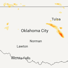
Hail Map for Wednesday, August 10, 2011

Number of Impacted Households on 8/10/2011
0
Impacted by 1" or Larger Hail
0
Impacted by 1.75" or Larger Hail
0
Impacted by 2.5" or Larger Hail
Square Miles of Populated Area Impacted on 8/10/2011
0
Impacted by 1" or Larger Hail
0
Impacted by 1.75" or Larger Hail
0
Impacted by 2.5" or Larger Hail


Cities Most Affected by Hail Storms of 8/10/2011
| Hail Size | Demographics of Zip Codes Affected | ||||||
|---|---|---|---|---|---|---|---|
| City | Count | Average | Largest | Pop Density | House Value | Income | Age |
| Sterling, CO | 5 | 2.05 | 3.00 | 31 | $91k | $32.2k | 37.3 |
| Merriman, NE | 2 | 1.75 | 1.75 | 0 | $30k | $26.6k | 47.3 |
| Kellyville, OK | 1 | 1.75 | 1.75 | 42 | $59k | $36.7k | 38.5 |
| Sparks, NE | 1 | 1.75 | 1.75 | 2 | $88k | $33.8k | 49.5 |
| Pine Bluffs, WY | 1 | 1.75 | 1.75 | 2 | $82k | $33.5k | 44.0 |
| Tuthill, SD | 1 | 1.75 | 1.75 | 0 | $38k | $29.6k | 50.6 |
| Sedgwick, CO | 1 | 1.75 | 1.75 | 1 | $50k | $29.4k | 50.6 |
Hail and Wind Damage Spotted on 8/10/2011
Filter by Report Type:Hail ReportsWind Reports
States Impacted
Arkansas, Oklahoma, Alabama, Vermont, New York, South Dakota, Tennessee, Mississippi, Wyoming, Nebraska, New Mexico, Rhode Island, Colorado, Florida, KansasArkansas
| Local Time | Report Details |
|---|---|
| 12:10 PM UTC | Trees and power lines down in the beaver fork are in faulkner county AR, 25.6 miles NNW of Little Rock, AR |
| 12:10 PM UTC | Trees dow in faulkner county AR, 25.6 miles NNW of Little Rock, AR |
| 12:11 PM UTC | Wind was estimated at 65 to 70 mp in faulkner county AR, 33.7 miles N of Little Rock, AR |
| 12:30 PM UTC | Wind estimated at 60mp in faulkner county AR, 23.1 miles N of Little Rock, AR |
Oklahoma
| Local Time | Report Details |
|---|---|
| 1:00 PM UTC | Ok mesonet in caddo county OK, 54.1 miles W of Oklahoma City, OK |
| 7:38 PM CDT | Golf Ball sized hail reported near Kellyville, OK, 18.9 miles SW of Tulsa, OK |
| 1:23 AM UTC | 50-60 mph winds. small hail north of tow in okmulgee county OK, 38 miles SSE of Tulsa, OK |
| 1:23 AM UTC | Storm damage reported in okmulgee county OK, 36 miles SSE of Tulsa, OK |
| 1:41 AM UTC | Thunderstorm wind gust estimated to 60 with tree damage. also had dime and nickel size hai in mcintosh county OK, 45.5 miles SSE of Tulsa, OK |
| 2:00 AM UTC | At lake eufaula state park...roofs blown off two boat slips. many tree limbs broken by wind. storage building blown over about 2 miles east of par in mcintosh county OK, 55.1 miles SSE of Tulsa, OK |
| 2:00 AM UTC | Half Dollar sized hail reported near Checotah, OK, 55.1 miles SSE of Tulsa, OK, penny to half dollar hail. hail piled up and still in piles thursday morning. |
| 2:17 AM UTC | Location approximate...20 by 60 metal building blown off foundation. blew 2x4s through car hoods. ripped upper 30 feet off radio tower...rated to withstand 90 mph winds in mcintosh county OK, 64.1 miles W of Fort Smith, AR |
| 2:18 AM UTC | Two buildings in town had roofs blown off. power out for 15 hours due to downed line in mcintosh county OK, 63.7 miles SSE of Tulsa, OK |
| 3:07 AM UTC | Quarter sized hail reported near Haskell, OK, 29.1 miles SE of Tulsa, OK |
Alabama
| Local Time | Report Details |
|---|---|
| 7:00 PM UTC | One tree down along why 17 near the intersection of hwy 32. powerlines also reported down in the area...but not confirme in pickens county AL, 42.5 miles SE of Starkville, MS |
| 9:12 PM UTC | Trees down in multiple locations...main areas northeast of marion in the sprott community along hwy 14 and 183. also county ro in perry county AL, 47.5 miles N of Camden, AL |
| 9:40 PM UTC | Trees down along hwy 219 and county road 139 in dallas county AL, 29 miles NNE of Camden, AL |
| 9:49 PM UTC | One tree dow in coffee county AL, 71.2 miles NNE of Miramar Beach, FL |
| 10:25 PM UTC | Trees down practically all over the northern portions of county. hard hit area was near carrollton along hwy 17 in pickens county AL, 43.6 miles ESE of Starkville, MS |
| 10:34 PM UTC | Trees down over a lot of the southern portions of the county...in and around aliceville. power and telephone lines down in the area as wel in pickens county AL, 44.3 miles ESE of Starkville, MS |
Vermont
| Local Time | Report Details |
|---|---|
| 7:24 PM UTC | Large tree down on shelburne road in chittenden county VT, 6.7 miles S of Burlington, VT |
| 8:45 PM UTC | Quarter sized hail reported near Middlebury, VT, 32.3 miles S of Burlington, VT, quarter-sized hail |
| 8:50 PM UTC | Quarter sized hail reported near Middlebury, VT, 35.3 miles S of Burlington, VT |
| 8:55 PM UTC | Quarter sized hail reported near Middlebury, VT, 35.1 miles SSE of Burlington, VT, hail lasted 15 minutes |
| 9:08 PM UTC | Half Dollar sized hail reported near Middlebury, VT, 34.7 miles S of Burlington, VT, middlebury state airport |
New York
| Local Time | Report Details |
|---|---|
| 7:30 PM UTC | Tree and wires down in oswego county NY, 23.7 miles NW of Syracuse, NY |
| 8:00 PM UTC | Quarter sized hail reported near Syracuse, NY, 0.8 miles SSE of Syracuse, NY |
| 8:10 PM UTC | Quarter sized hail reported near Salina, NY, 3.5 miles N of Syracuse, NY |
| 8:10 PM UTC | Quarter sized hail reported near Syracuse, NY, 0.8 miles SSE of Syracuse, NY |
| 8:22 PM UTC | Half Dollar sized hail reported near Syracuse, NY, 0.8 miles SSE of Syracuse, NY |
| 8:27 PM UTC | Half Dollar sized hail reported near East Syracuse, NY, 4 miles E of Syracuse, NY |
| 8:30 PM UTC | Multiple trees and wires down on hier ave in onondaga county NY, 0.8 miles SSE of Syracuse, NY |
| 8:35 PM UTC | Tree fell on house on verbeck drive in onondaga county NY, 9.2 miles ESE of Syracuse, NY |
| 8:40 PM UTC | Trees downed in madison county NY, 14 miles E of Syracuse, NY |
| 8:50 PM UTC | Trees downed in madison county NY, 19.7 miles E of Syracuse, NY |
| 9:08 PM UTC | Trees downed in madison county NY, 29.1 miles E of Syracuse, NY |
| 9:22 PM UTC | Tree down in oneida county NY, 38.9 miles E of Syracuse, NY |
South Dakota
| Local Time | Report Details |
|---|---|
| 7:40 PM UTC | Quarter sized hail reported near Keystone, SD, 15.1 miles SSW of Rapid City, SD |
| 9:33 PM UTC | Quarter sized hail reported near Martin, SD, 58.3 miles WNW of Valentine, NE, ground white with hail. |
| 9:58 PM UTC | Golf Ball sized hail reported near Tuthill, SD, 52.3 miles WNW of Valentine, NE, estimated 60 mph winds. funnel cloud visible about 2 mi west this location at 1545 |
| 9:58 PM UTC | Storm damage reported in bennett county SD, 52.3 miles WNW of Valentine, NE |
| 10:45 PM UTC | Ping Pong Ball sized hail reported near Martin, SD, 68.9 miles WNW of Valentine, NE |
| 11:15 PM UTC | Quarter sized hail reported near Martin, SD, 68.9 miles WNW of Valentine, NE, 45-50 mph wind gusts at time of largest hail |
Tennessee
| Local Time | Report Details |
|---|---|
| 8:43 PM UTC | Quarter sized hail reported near Jackson, TN, 41.9 miles SSW of Mc Kenzie, TN, mostly dime size hail...however some pieces are up to quarter size. |
| 8:52 PM UTC | Quarter sized hail reported near Jackson, TN, 41.9 miles SSW of Mc Kenzie, TN, nickel to quarter size hail reported near bemis. |
Mississippi
| Local Time | Report Details |
|---|---|
| 9:10 PM UTC | A few trees were blown down along with a cable lin in clay county MS, 14.1 miles NE of Starkville, MS |
| 9:30 PM UTC | Kgtr awos reports 50 kt wind gust. unconfirmed 73 mph gust also reported at the airport via lowndes em in lowndes county MS, 13.5 miles E of Starkville, MS |
| 9:45 PM UTC | 3 trees were blown dow in lowndes county MS, 24 miles E of Starkville, MS |
| 10:05 PM UTC | A couple trees were blown dow in noxubee county MS, 30.6 miles ESE of Starkville, MS |
| 10:05 PM UTC | 7 trees blown down around the pecan grove communit in jones county MS, 77.8 miles SE of Jackson, MS |
| 9:17 AM UTC | Two trees down on hwy 8 near the high school...reported by wabg-tv in bolivar county MS, 95.4 miles NE of Bastrop, LA |
| 10:25 AM UTC | Several trees and powerlines down in the city of greenwood in leflore county MS, 79.6 miles W of Starkville, MS |
| 11:00 AM UTC | Several trees down along with a few power lines in carroll county MS, 64 miles W of Starkville, MS |
Wyoming
| Local Time | Report Details |
|---|---|
| 9:50 PM UTC | Half Dollar sized hail reported near Pine Bluffs, WY, 51.6 miles SSW of Scottsbluff, NE, hail ranged in size from 1 inch to 1.25 inches. |
| 9:55 PM UTC | Golf Ball sized hail reported near Pine Bluffs, WY, 51.6 miles SSW of Scottsbluff, NE, also heavy rain with some minor flooding. |
| 2:38 AM UTC | Extensive damage to front porch and part of roof on home due to wind in natrona county WY, 18.2 miles W of Casper, WY |
Nebraska
| Local Time | Report Details |
|---|---|
| 9:50 PM UTC | Golf Ball sized hail reported near Sparks, NE, 16.4 miles ENE of Valentine, NE, ground covered white with hail with the largest up to golf ball size. |
| 11:41 PM UTC | Ping Pong Ball sized hail reported near Cody, NE, 41.1 miles W of Valentine, NE |
| 12:15 AM UTC | Quarter sized hail reported near Cody, NE, 35.8 miles W of Valentine, NE, hail made ground white...also accompanied by 40 mph winds |
| 12:15 AM UTC | Quarter sized hail reported near Cody, NE, 40.6 miles W of Valentine, NE, hail made ground white...also accompanied by 40 mph winds |
| 12:30 AM UTC | Quarter sized hail reported near Cody, NE, 39.6 miles WSW of Valentine, NE |
| 12:40 AM UTC | Golf Ball sized hail reported near Merriman, NE, 41.9 miles SW of Valentine, NE |
| 12:40 AM UTC | Golf Ball sized hail reported near Merriman, NE, 42 miles WSW of Valentine, NE, reported seeing a rotating wall cloud just to the north of the location. |
| 1:24 AM UTC | Storm damage reported in cherry county NE, 58.5 miles SW of Valentine, NE |
| 1:24 AM UTC | Quarter sized hail reported near Merriman, NE, 58.5 miles SW of Valentine, NE |
| 2:00 AM UTC | Quarter sized hail reported near Mullen, NE, 63.2 miles SSW of Valentine, NE |
| 2:13 AM UTC | Golf Ball sized hail reported near , , 62.1 miles NNW of North Platte, NE |
New Mexico
| Local Time | Report Details |
|---|---|
| 10:00 PM UTC | 3 inch diameter limbs blown dow in de baca county NM, 59.2 miles NNE of Roswell, NM |
Rhode Island
| Local Time | Report Details |
|---|---|
| 11:17 PM UTC | Trees and wires down on wrentham road in providence county RI, 10.4 miles NNW of Providence, RI |
Colorado
| Local Time | Report Details |
|---|---|
| 11:33 PM UTC | Ping Pong Ball sized hail reported near Sterling, CO, 53.8 miles NW of Yuma, CO |
| 11:37 PM UTC | Quarter sized hail reported near Sterling, CO, 54.7 miles NW of Yuma, CO |
| 11:44 PM UTC | Tea Cup sized hail reported near Sterling, CO, 53.8 miles NW of Yuma, CO, broken windows to vehicle |
| 12:08 AM UTC | Logan county fairgrounds in logan county CO, 44.8 miles NW of Yuma, CO |
| 12:09 AM UTC | Quarter sized hail reported near Sterling, CO, 44.8 miles NW of Yuma, CO |
| 12:10 AM UTC | Ping Pong Ball sized hail reported near Sterling, CO, 44.8 miles NW of Yuma, CO |
| 12:10 AM UTC | Sterling airport in logan county CO, 45.5 miles NW of Yuma, CO |
| 12:12 AM UTC | Golf Ball sized hail reported near Sterling, CO, 44.8 miles NW of Yuma, CO, sterling high school |
| 12:14 AM UTC | Ping Pong Ball sized hail reported near Julesburg, CO, 64.9 miles NNE of Yuma, CO |
| 12:14 AM UTC | Golf Ball sized hail reported near Sterling, CO, 45.9 miles NW of Yuma, CO, extensive crop damage |
| 12:15 AM UTC | Ping Pong Ball sized hail reported near Julesburg, CO, 64.9 miles NNE of Yuma, CO |
| 12:15 AM UTC | Golf Ball sized hail reported near Sedgwick, CO, 56.9 miles N of Yuma, CO, car |
| 12:20 AM UTC | Ping Pong Ball sized hail reported near Julesburg, CO, 64.9 miles NNE of Yuma, CO, severe damage to veh |
| 12:22 AM UTC | Row of trailers and recreational vehicles blown over in logan county CO, 45.4 miles NW of Yuma, CO |
| 12:42 AM UTC | Hen Egg sized hail reported near Sterling, CO, 27.5 miles NNW of Yuma, CO |
| 12:48 AM UTC | Ping Pong Ball sized hail reported near Julesburg, CO, 61.8 miles NNE of Yuma, CO |
| 12:51 AM UTC | Quarter sized hail reported near Otis, CO, 23.7 miles NNW of Yuma, CO |
| 1:09 AM UTC | Quarter sized hail reported near Otis, CO, 18.7 miles NW of Yuma, CO, extensive crop damage |
| 1:40 AM UTC | Golf Ball sized hail reported near Sterling, CO, 43.3 miles NNW of Yuma, CO |
| 3:00 AM UTC | Quarter sized hail reported near Yuma, CO, 18.1 miles N of Yuma, CO |
Florida
| Local Time | Report Details |
|---|---|
| 12:20 AM UTC | Trained spotter reports wind gust around 50 mph. small tree limbs less than 2 inches thick were reported down around the eucheeanna communit in walton county FL, 26.5 miles NE of Miramar Beach, FL |
Kansas
| Local Time | Report Details |
|---|---|
| 9:00 AM UTC | Some trees downed in vicinity of coffeyvill in montgomery county KS, 45.4 miles SSW of Chanute, KS |
Connect with Interactive Hail Maps