

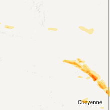
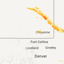
Hail Map for Tuesday, August 9, 2011

Number of Impacted Households on 8/9/2011
0
Impacted by 1" or Larger Hail
0
Impacted by 1.75" or Larger Hail
0
Impacted by 2.5" or Larger Hail
Square Miles of Populated Area Impacted on 8/9/2011
0
Impacted by 1" or Larger Hail
0
Impacted by 1.75" or Larger Hail
0
Impacted by 2.5" or Larger Hail


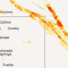


Cities Most Affected by Hail Storms of 8/9/2011
| Hail Size | Demographics of Zip Codes Affected | ||||||
|---|---|---|---|---|---|---|---|
| City | Count | Average | Largest | Pop Density | House Value | Income | Age |
| Plainville, KS | 4 | 2.63 | 4.25 | 8 | $43k | $30.7k | 42.6 |
| Bogue, KS | 3 | 2.42 | 2.75 | 1 | $32k | $24.0k | 53.1 |
| Hayes Center, NE | 3 | 2.08 | 2.75 | 1 | $34k | $26.9k | 47.0 |
| Sidney, NE | 3 | 1.92 | 2.00 | 18 | $61k | $34.3k | 38.2 |
| Herndon, KS | 3 | 1.83 | 2.00 | 1 | $22k | $25.2k | 53.3 |
| Moriarty, NM | 3 | 1.75 | 1.75 | 11 | $91k | $30.3k | 39.2 |
| Damar, KS | 2 | 2.50 | 2.50 | 2 | $25k | $27.5k | 43.8 |
| Paxton, NE | 2 | 2.13 | 2.50 | 2 | $55k | $30.8k | 43.4 |
| Norcatur, KS | 2 | 2.13 | 2.50 | 1 | $37k | $27.2k | 49.0 |
| Trenton, NE | 2 | 2.00 | 2.00 | 1 | $38k | $26.8k | 49.1 |
| Yoder, WY | 2 | 1.88 | 2.00 | 1 | $66k | $30.4k | 49.6 |
| Atwood, KS | 2 | 1.88 | 2.00 | 4 | $49k | $32.6k | 50.7 |
| Mc Cook, NE | 2 | 1.75 | 1.75 | 21 | $63k | $32.2k | 40.9 |
| Madrid, NE | 2 | 1.75 | 1.75 | 2 | $38k | $35.2k | 35.9 |
| Nova, OH | 2 | 1.75 | 1.75 | 56 | $105k | $47.7k | 41.7 |
| Sutherland, NE | 2 | 1.75 | 1.75 | 3 | $74k | $38.9k | 40.6 |
| Catharine, KS | 2 | 1.75 | 1.75 | 0 | $0k | $0.0k | 0.0 |
| Natoma, KS | 2 | 1.75 | 1.75 | 2 | $19k | $27.0k | 45.6 |
| Imperial, NE | 2 | 1.75 | 1.75 | 2 | $67k | $34.4k | 41.3 |
| Hill City, KS | 1 | 2.75 | 2.75 | 7 | $46k | $31.3k | 48.4 |
| Danbury, NE | 1 | 2.75 | 2.75 | 3 | $27k | $35.5k | 45.5 |
| Wallace, NE | 1 | 2.75 | 2.75 | 1 | $55k | $36.5k | 42.3 |
| Fort Laramie, WY | 1 | 2.75 | 2.75 | 1 | $57k | $26.9k | 52.0 |
| Palco, KS | 1 | 2.50 | 2.50 | 1 | $22k | $29.7k | 39.5 |
| Ellis, KS | 1 | 2.00 | 2.00 | 8 | $55k | $30.4k | 40.4 |
| Crook, CO | 1 | 2.00 | 2.00 | 1 | $53k | $26.0k | 50.8 |
| Stratton, NE | 1 | 1.75 | 1.75 | 1 | $38k | $26.1k | 50.9 |
| Brownell, KS | 1 | 1.75 | 1.75 | 1 | $24k | $37.1k | 51.4 |
| Benkelman, NE | 1 | 1.75 | 1.75 | 3 | $33k | $26.9k | 46.8 |
| Defiance, OH | 1 | 1.75 | 1.75 | 133 | $88k | $45.7k | 39.7 |
| Chappell, NE | 1 | 1.75 | 1.75 | 1 | $50k | $36.1k | 47.6 |
| Venango, NE | 1 | 1.75 | 1.75 | 1 | $31k | $29.8k | 49.6 |
| Bunker Hill, KS | 1 | 1.75 | 1.75 | 1 | $34k | $31.3k | 50.9 |
| Wheatland, WY | 1 | 1.75 | 1.75 | 3 | $89k | $35.1k | 47.3 |
| Wauneta, NE | 1 | 1.75 | 1.75 | 1 | $40k | $30.1k | 50.2 |
| Logan, KS | 1 | 1.75 | 1.75 | 2 | $35k | $29.3k | 45.7 |
| Arthur, NE | 1 | 1.75 | 1.75 | 0 | $48k | $30.5k | 43.8 |
| Oberlin, KS | 1 | 1.75 | 1.75 | 5 | $49k | $31.7k | 50.5 |
| Cheyenne, WY | 1 | 1.75 | 1.75 | 26 | $135k | $54.6k | 42.7 |
| Culbertson, NE | 1 | 1.75 | 1.75 | 3 | $42k | $33.3k | 45.9 |
| Nekoma, KS | 1 | 1.75 | 1.75 | 1 | $13k | $25.8k | 51.0 |
| Elsie, NE | 1 | 1.75 | 1.75 | 1 | $36k | $40.4k | 46.2 |
| Palisade, NE | 1 | 1.75 | 1.75 | 2 | $33k | $24.9k | 48.5 |
| Dresden, KS | 1 | 1.75 | 1.75 | 2 | $29k | $24.9k | 49.9 |
| Norton, KS | 1 | 1.75 | 1.75 | 10 | $55k | $31.1k | 42.6 |
| Stratton, CO | 1 | 1.75 | 1.75 | 2 | $77k | $35.0k | 37.2 |
| Russell, KS | 1 | 1.75 | 1.75 | 15 | $46k | $30.2k | 45.3 |
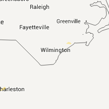
Hail and Wind Damage Spotted on 8/9/2011
Filter by Report Type:Hail ReportsWind Reports
States Impacted
Delaware, New Jersey, New York, Nebraska, Georgia, Mississippi, Michigan, Wyoming, New Mexico, Maryland, Indiana, Colorado, Texas, Alabama, Ohio, South Carolina, Kansas, Oklahoma, ArkansasDelaware
| Local Time | Report Details |
|---|---|
| 4:22 PM UTC | Trees down with some house damage near coffee runn and bella vista in new castle county DE, 59.8 miles ENE of Baltimore, MD |
| 4:30 PM UTC | Trees down west of wilminnton in new castle county DE, 62.7 miles ENE of Baltimore, MD |
| 4:40 PM UTC | Trees down in new castle county DE, 70 miles ENE of Baltimore, MD |
| 4:44 PM UTC | Half Dollar sized hail reported near Claymont, DE, 70.7 miles ENE of Baltimore, MD |
| 4:45 PM UTC | Quarter sized hail reported near Newark, DE, 54.7 miles ENE of Baltimore, MD |
| 4:45 PM UTC | Quarter sized hail reported near Wilmington, DE, 65 miles ENE of Baltimore, MD |
| 4:45 PM UTC | Trees down north of wilmington in new castle county DE, 70.7 miles ENE of Baltimore, MD |
| 4:45 PM UTC | Trees down with car and house damage in new castle county DE, 59.6 miles NE of Baltimore, MD |
New Jersey
| Local Time | Report Details |
|---|---|
| 5:13 PM UTC | Tree down in logan twp in gloucester county NJ, 75.1 miles ENE of Baltimore, MD |
| 5:15 PM UTC | Telephone wires down in woodstown in salem county NJ, 72.8 miles ENE of Baltimore, MD |
| 5:30 PM UTC | Tree down in mantua twp in gloucester county NJ, 84.3 miles ENE of Baltimore, MD |
| 5:40 PM UTC | Tree down in deptford in gloucester county NJ, 84.8 miles SW of Brooklyn, NY |
New York
| Local Time | Report Details |
|---|---|
| 6:15 PM UTC | Trees down in cayuga county NY, 19.2 miles WSW of Syracuse, NY |
| 7:30 PM UTC | Trees and powerlines downed in cortland county NY, 42.5 miles S of Syracuse, NY |
| 8:13 PM UTC | Several trees downed in oneida county NY, 24.9 miles ENE of Syracuse, NY |
| 8:26 PM UTC | Fire dept called out for trees and wires dow in broome county NY, 57.6 miles N of Scranton, PA |
| 9:00 PM UTC | Trees downed in oneida county NY, 50.8 miles NE of Syracuse, NY |
| 9:36 PM UTC | Trees downed in otsego county NY, 65.5 miles SE of Syracuse, NY |
| 9:52 PM UTC | Trees downed in otsego county NY, 67.1 miles SE of Syracuse, NY |
Nebraska
| Local Time | Report Details |
|---|---|
| 6:57 PM UTC | Golf Ball sized hail reported near Arthur, NE, 57.5 miles WNW of North Platte, NE, public reported golf ball sized hail 3 miles southwest of arthur. |
| 7:36 PM UTC | Tennis Ball sized hail reported near Paxton, NE, 31.3 miles W of North Platte, NE, public reported tennis ball sized hail 4 miles north of paxton. |
| 7:37 PM UTC | Quarter sized hail reported near Arthur, NE, 53.5 miles WNW of North Platte, NE, nebraska department of roads reported they are plowing roads north of lake mcconaughy due to hail 6 inches deep on roads. hail sizes up to the size of a quarter. |
| 7:40 PM UTC | Ping Pong Ball sized hail reported near Paxton, NE, 31.2 miles W of North Platte, NE |
| 7:44 PM UTC | Golf Ball sized hail reported near Paxton, NE, 28.1 miles W of North Platte, NE, nerain observer reported golf ball sized hail and broken windows in sutherland. |
| 7:55 PM UTC | Golf Ball sized hail reported near Sutherland, NE, 19.2 miles W of North Platte, NE, law enforcement dispatch reported golf ball sized hail covering the ground near sutherland power plant. |
| 7:57 PM UTC | Golf Ball sized hail reported near Sutherland, NE, 19.2 miles W of North Platte, NE, public reported golf ball sized hail in sutherland. |
| 8:01 PM UTC | Golf Ball sized hail reported near Elsie, NE, 30.4 miles WSW of North Platte, NE, public reported golf ball sized hail broke windows out of their house 8 miles northwest of wallace. |
| 8:22 PM UTC | Half Dollar sized hail reported near Sidney, NE, 61.4 miles SE of Scottsbluff, NE |
| 8:23 PM UTC | Quarter sized hail reported near Sidney, NE, 62 miles SE of Scottsbluff, NE, mostly 1 inch hail with some a bit larger. |
| 8:23 PM UTC | Golf Ball sized hail reported near Sidney, NE, 62 miles SE of Scottsbluff, NE |
| 8:26 PM UTC | Quarter sized hail reported near Sidney, NE, 61.4 miles SE of Scottsbluff, NE |
| 8:32 PM UTC | Baseball sized hail reported near Wallace, NE, 29.1 miles SW of North Platte, NE, law enforcement reported baseball sized hail in wallace. |
| 8:35 PM UTC | Baseball sized hail reported near Hayes Center, NE, 35.6 miles SSW of North Platte, NE, public reported baseball sized hail 10 miles north northeast of hayes center. |
| 8:36 PM UTC | Hen Egg sized hail reported near Sidney, NE, 62 miles SE of Scottsbluff, NE, some stones as large as 2.25 inches. spotter is located 2 miles southeast of the gordon mobile plaza |
| 8:39 PM UTC | Golf Ball sized hail reported near Hayes Center, NE, 38.7 miles SSW of North Platte, NE, spotter reported golf ball sized hail 7 miles north of hayes center. |
| 8:55 PM UTC | Quarter sized hail reported near Chappell, NE, 65.3 miles NNE of Yuma, CO, public reported quarter sized hail 6 miles southeast of chappell. |
| 8:56 PM UTC | Ping Pong Ball sized hail reported near Hayes Center, NE, 40.2 miles SSW of North Platte, NE, law enforcement reported ping pong ball sized hail 6 miles northeast of hayes center. |
| 9:00 PM UTC | Quarter sized hail reported near Chappell, NE, 65.3 miles N of Yuma, CO |
| 9:23 PM UTC | Storm damage reported in hitchcock county NE, 60.5 miles N of Colby, KS |
| 9:30 PM UTC | Quarter sized hail reported near McCook, NE, 55.3 miles S of North Platte, NE, emergency mgr relayed report from law enforcement on hwy 83 just south of red willow/frontier co. line. |
| 9:30 PM UTC | Storm damage reported in red willow county NE, 65.1 miles SSE of North Platte, NE |
| 9:40 PM UTC | Ping Pong Ball sized hail reported near McCook, NE, 59.8 miles NNE of Colby, KS, *** 1 inj *** spotter also reports many skylights at local walmart blown out and store is currently shut down. also reported one minor injury. |
| 9:40 PM UTC | Golf Ball sized hail reported near McCook, NE, 59.8 miles NNE of Colby, KS, reported on west side of town. |
| 9:45 PM UTC | Quarter sized hail reported near McCook, NE, 59.4 miles NNE of Colby, KS, from severe hazards analysis and verification experiment |
| 9:47 PM UTC | Quarter sized hail reported near Madrid, NE, 62.5 miles WSW of North Platte, NE, law enforcement reported quarter sized hail 10 miles east of venango. |
| 9:47 PM UTC | Golf Ball sized hail reported near Venango, NE, 57.1 miles NE of Yuma, CO, sheriff reported ping pong ball and golf ball sized hail in venango. |
| 9:48 PM UTC | Storm damage reported in red willow county NE, 59.8 miles NNE of Colby, KS |
| 9:49 PM UTC | Quarter sized hail reported near McCook, NE, 59.8 miles NNE of Colby, KS, public report also included estimated 60 mph winds. |
| 9:50 PM UTC | Golf Ball sized hail reported near McCook, NE, 59.8 miles NNE of Colby, KS, reported on east side of town. |
| 10:01 PM UTC | Ping Pong Ball sized hail reported near Danbury, NE, 56.5 miles NNE of Colby, KS, spotter also reports windows broken and estimates winds of at least 60 mph. |
| 10:05 PM UTC | Baseball sized hail reported near Danbury, NE, 56.1 miles NE of Colby, KS, also had golf ball size hail at the same time. |
| 10:11 PM UTC | Golf Ball sized hail reported near Madrid, NE, 62.3 miles NE of Yuma, CO, public reported golf ball sized hail 12 miles northeast of lamar. |
| 10:24 PM UTC | Quarter sized hail reported near McCook, NE, 61.1 miles NNE of Colby, KS, from severe hazards analysis and verification experiment |
| 10:25 PM UTC | Golf Ball sized hail reported near Imperial, NE, 62.6 miles SW of North Platte, NE |
| 10:38 PM UTC | Quarter sized hail reported near Wauneta, NE, 61.8 miles SW of North Platte, NE |
| 10:45 PM UTC | Ping Pong Ball sized hail reported near Wauneta, NE, 63.7 miles SW of North Platte, NE |
| 10:45 PM UTC | Golf Ball sized hail reported near Benkelman, NE, 66.3 miles SSW of North Platte, NE |
| 10:55 PM UTC | Quarter sized hail reported near Venango, NE, 58.5 miles WSW of North Platte, NE |
| 11:08 PM UTC | Half Dollar sized hail reported near Grant, NE, 54.5 miles WSW of North Platte, NE, quarter to half dollar size hail. |
| 11:11 PM UTC | Quarter sized hail reported near Grant, NE, 54 miles WSW of North Platte, NE, public reported quarter sized hail on the north edge of grant. |
| 11:14 PM UTC | Golf Ball sized hail reported near Stratton, NE, 52.9 miles N of Colby, KS, corrected location |
| 11:41 PM UTC | Quarter sized hail reported near Madrid, NE, 43.5 miles SW of North Platte, NE, public reported quarter sized hail 7 miles southeast of madrid. |
| 11:45 PM UTC | Quarter sized hail reported near Madrid, NE, 41.8 miles SW of North Platte, NE |
| 12:00 AM UTC | Golf Ball sized hail reported near Madrid, NE, 55 miles WSW of North Platte, NE, covered the ground. |
| 12:16 AM UTC | Half Dollar sized hail reported near Imperial, NE, 56.5 miles SW of North Platte, NE, public reported half-dollar sized hail 10 miles north of imperial. |
| 12:22 AM UTC | Golf Ball sized hail reported near Imperial, NE, 57.6 miles SW of North Platte, NE, public reported golf ball sized hail 5 miles northeast of imperial. |
| 12:28 AM UTC | Golf Ball sized hail reported near Hayes Center, NE, 45.3 miles SSW of North Platte, NE |
| 12:29 AM UTC | Golf Ball sized hail reported near Wauneta, NE, 55.9 miles SW of North Platte, NE |
| 1:01 AM UTC | Quarter sized hail reported near Palisade, NE, 58.7 miles NNW of Colby, KS |
| 1:02 AM UTC | Golf Ball sized hail reported near Palisade, NE, 62.8 miles N of Colby, KS, report also included estimated winds of 60-70 mph. |
| 1:25 AM UTC | Hen Egg sized hail reported near Trenton, NE, 53.4 miles N of Colby, KS, also measured 42 mph wind gust. |
| 1:30 AM UTC | Hen Egg sized hail reported near Trenton, NE, 53.4 miles N of Colby, KS, hailed for 10 minutes. dented cars and broke siding on house. |
| 1:40 AM UTC | Golf Ball sized hail reported near Culbertson, NE, 48.9 miles N of Colby, KS |
| 2:30 AM UTC | Half Dollar sized hail reported near Imperial, NE, 60.6 miles NE of Yuma, CO |
| 2:30 AM UTC | Ping Pong Ball sized hail reported near Big Springs, NE, 71.6 miles NNE of Yuma, CO |
| 2:35 AM UTC | Quarter sized hail reported near Harrisburg, NE, 28 miles S of Scottsbluff, NE |
| 2:52 AM UTC | Quarter sized hail reported near Kimball, NE, 34.6 miles S of Scottsbluff, NE |
| 3:27 AM UTC | Quarter sized hail reported near Bridgeport, NE, 40.4 miles SE of Scottsbluff, NE |
| 3:39 AM UTC | Hen Egg sized hail reported near Sidney, NE, 62 miles SE of Scottsbluff, NE, gust to 54 mph at the airport. tree branches down. |
| 3:49 AM UTC | Quarter sized hail reported near Sidney, NE, 60.8 miles SE of Scottsbluff, NE, lots of hail on the ground. |
| 3:51 AM UTC | Quarter sized hail reported near Sidney, NE, 57 miles SE of Scottsbluff, NE, hail ranges in size from 1 inch to 13/4 inch. |
| 4:12 AM UTC | Law enforcement estimated 60 mph winds in chappel in deuel county NE, 68.3 miles N of Yuma, CO |
| 4:12 AM UTC | Golf Ball sized hail reported near Chappell, NE, 68.3 miles N of Yuma, CO |
Georgia
| Local Time | Report Details |
|---|---|
| 7:10 PM UTC | Quarter sized hail reported near Shiloh, GA, 45 miles ENE of Auburn, AL, trained spotter reported quarter-sized hail and downed trees. |
| 7:10 PM UTC | Trained spotter reported quarter-sized hail and downed tree in harris county GA, 45 miles ENE of Auburn, AL |
| 7:55 PM UTC | Pike county 911 relayed a report of a tree down on the north side of zebulo in pike county GA, 43.4 miles S of Atlanta, GA |
| 7:55 PM UTC | Pike county 911 relayed a report of a downed tree near williamso in pike county GA, 41.4 miles S of Atlanta, GA |
| 8:01 PM UTC | Lamar county 911 relayed reports of numerous downed trees in the county. a telegraph pole was also reported downed onto a ca in lamar county GA, 45.3 miles SSE of Atlanta, GA |
| 8:24 PM UTC | Monroe county 911 relayed reports of 2-3 downed trees in the county so fa in monroe county GA, 56 miles SSE of Atlanta, GA |
| 8:24 PM UTC | Monroe county 911 relayed reports of numerous downed trees in the count in monroe county GA, 56 miles SSE of Atlanta, GA |
| 8:24 PM UTC | Monroe county 911 relayed reports of numerous downed trees in the county. half a dozen houses with tree damage and a house with part of its roof damaged by wind in monroe county GA, 56 miles SSE of Atlanta, GA |
| 8:30 PM UTC | Off duty nws employee reports a handful of downed trees from mile marker 152 through mile marker 155 on interstate 8 in banks county GA, 60.7 miles SW of Greenville, SC |
| 8:45 PM UTC | One tree down on hw-326 between rock pillar road and mcadams roa in franklin county GA, 51.9 miles SW of Greenville, SC |
| 8:45 PM UTC | One tree down on bold springs roa in franklin county GA, 54.1 miles SW of Greenville, SC |
| 8:50 PM UTC | Macon-bibb county 911 relayed 4 reports of several downed powerlines around the count in bibb county GA, 76.8 miles SE of Atlanta, GA |
| 8:50 PM UTC | Bleckley county 911 reported a couple of downed trees in the count in bleckley county GA, 69.8 miles NNW of Douglas, GA |
| 8:55 PM UTC | Fort benning 911 relayed a report of a downed line near building 169 in chattahoochee county GA, 34.3 miles ESE of Auburn, AL |
| 8:55 PM UTC | Fort benning 911 relayed a report of a downed line near building 169 in chattahoochee county GA, 34 miles SE of Auburn, AL |
| 9:03 PM UTC | Jones county 911 relayed a report of a couple of downed powerlines and a blown transforme in jones county GA, 72.3 miles SE of Atlanta, GA |
| 9:15 PM UTC | One tree down on hw-172 in elbert county GA, 49.9 miles SSW of Greenville, SC |
| 9:15 PM UTC | Twiggs county 911 relayed reports of several downed trees all over the count in twiggs county GA, 85.9 miles NNW of Douglas, GA |
| 9:18 PM UTC | Jefferson county 911 relayed reports of over a dozen downed trees in the eastern end of the count in jefferson county GA, 50 miles SSW of Augusta, GA |
| 9:25 PM UTC | Large limb down partially blocking hwy 17 going nort in elbert county GA, 50.1 miles SSW of Greenville, SC |
| 9:30 PM UTC | Emanuel county 911 relayed a report of a downed tree near cahooche in emanuel county GA, 54 miles S of Augusta, GA |
| 9:50 PM UTC | Crisp county 911 relayed report of a downed tree. water was also reported over ga 300 near culpeppe in crisp county GA, 63.1 miles WNW of Douglas, GA |
| 10:05 PM UTC | Trees blown down on several houses in mette in candler county GA, 60.9 miles WNW of Savannah, GA |
| 10:08 PM UTC | Trees and powerlines blown down on several cars at the high school just south of downtown mette in candler county GA, 59.6 miles WNW of Savannah, GA |
| 10:10 PM UTC | Telfair county 911 relayed report of a downed tre in telfair county GA, 21.7 miles N of Douglas, GA |
| 10:15 PM UTC | Trees down along rocky ford roa in screven county GA, 57.7 miles S of Augusta, GA |
| 10:25 PM UTC | Toombs county 911 relayed reports of 4-5 downed tree in toombs county GA, 44.3 miles NE of Douglas, GA |
| 10:30 PM UTC | The tattnall county warning point reported numerous trees down in reidsville...georgia. one tree was reported down on a hom in tattnall county GA, 58.9 miles NE of Douglas, GA |
| 10:45 PM UTC | Numerous reports of trees down in hubert...stilson and arcola. time estimated by rada in bulloch county GA, 29.5 miles WNW of Savannah, GA |
| 10:45 PM UTC | Trees down along highway 301 nort in evans county GA, 47.3 miles WNW of Savannah, GA |
| 11:10 PM UTC | The tattnall county warning point reported trees and powerlines down in glennville...georgi in tattnall county GA, 50.2 miles W of Savannah, GA |
| 11:41 PM UTC | The chatham county warning point reported a tree down on the west side of savannah...georgi in chatham county GA, 4.5 miles WNW of Savannah, GA |
| 11:58 PM UTC | The chatham county warning point reported a tree down on the south side of savannah...georgi in chatham county GA, 4.9 miles S of Savannah, GA |
| 12:03 AM UTC | The chatham county warning point reported a power line down on the east side of savannah...georgi in chatham county GA, 3.7 miles SE of Savannah, GA |
Mississippi
| Local Time | Report Details |
|---|---|
| 7:20 PM UTC | Trees and powerlines down on maiden r in lauderdale county MS, 68 miles S of Starkville, MS |
| 12:12 AM UTC | Tree downed and blocking traffic on north s in rankin county MS, 10.6 miles E of Jackson, MS |
| 12:20 AM UTC | Four small trees and one large tree down across cr 68 blocking traffic...reported by em in smith county MS, 49.1 miles SE of Jackson, MS |
Michigan
| Local Time | Report Details |
|---|---|
| 7:55 PM UTC | Reported small tree branches down up to 3 inches in diamete in oakland county MI, 34.2 miles SSE of Flint, MI |
| 8:15 PM UTC | Storm damage reported in oakland county MI, 34.2 miles SSE of Flint, MI |
| 8:15 PM UTC | Quarter sized hail reported near Orchard Lake Village, MI, 34.2 miles SSE of Flint, MI |
| 9:08 PM UTC | Quarter sized hail reported near Milan, MI, 62.9 miles S of Flint, MI |
Wyoming
| Local Time | Report Details |
|---|---|
| 8:34 PM UTC | Quarter sized hail reported near Thermopolis, WY, 49.8 miles NNE of Riverton, WY |
| 8:40 PM UTC | Quarter sized hail reported near Thermopolis, WY, 51.1 miles NNE of Riverton, WY |
| 9:45 PM UTC | Quarter sized hail reported near Gillette, WY, 45 miles S of Gillette, WY |
| 10:05 PM UTC | Storm damage reported in campbell county WY, 49 miles SSE of Gillette, WY |
| 10:05 PM UTC | 6-7 inch diameter cottonwood branches broken off in campbell county WY, 49 miles SSE of Gillette, WY |
| 10:20 PM UTC | Quarter sized hail reported near Newcastle, WY, 56 miles SSE of Gillette, WY |
| 10:50 PM UTC | Quarter sized hail reported near Kaycee, WY, 52.9 miles N of Casper, WY |
| 12:20 AM UTC | Golf Ball sized hail reported near Wheatland, WY, 70.7 miles NNE of Laramie, WY, hail fell at interstate 25 milepost 100. |
| 12:30 AM UTC | Five power poles knocked down starting at intersection of wyoming 320 and us highway 26 and going to the east. golfball sized hail so deep highway department had to be in platte county WY, 69.5 miles NNE of Laramie, WY |
| 12:51 AM UTC | A camper was blown over in the campground. marble sized hail was reported als in platte county WY, 57.9 miles WNW of Scottsbluff, NE |
| 12:57 AM UTC | Downed power line in platte county WY, 65.8 miles WNW of Scottsbluff, NE |
| 1:00 AM UTC | Ping Pong Ball sized hail reported near Wheatland, WY, 56.2 miles WNW of Scottsbluff, NE |
| 1:24 AM UTC | Quarter sized hail reported near Yoder, WY, 37.7 miles W of Scottsbluff, NE |
| 1:27 AM UTC | Quarter sized hail reported near Yoder, WY, 47.8 miles W of Scottsbluff, NE, very heavy rain appx 2 inches. ground is completly covered with hail. |
| 1:30 AM UTC | Baseball sized hail reported near Fort Laramie, WY, 49.3 miles WNW of Scottsbluff, NE, some windows broken. |
| 1:31 AM UTC | Golf Ball sized hail reported near Yoder, WY, 32.6 miles W of Scottsbluff, NE |
| 1:34 AM UTC | Quarter sized hail reported near Torrington, WY, 33.5 miles WNW of Scottsbluff, NE |
| 1:35 AM UTC | Hen Egg sized hail reported near Yoder, WY, 31.7 miles W of Scottsbluff, NE |
| 1:48 AM UTC | Quarter sized hail reported near La Grange, WY, 27.2 miles WSW of Scottsbluff, NE |
| 3:44 AM UTC | Golf Ball sized hail reported near Cheyenne, WY, 36.4 miles E of Laramie, WY |
| 3:46 AM UTC | Quarter sized hail reported near Cheyenne, WY, 41.7 miles E of Laramie, WY |
| 3:55 AM UTC | Quarter sized hail reported near Cheyenne, WY, 44.3 miles ESE of Laramie, WY |
New Mexico
| Local Time | Report Details |
|---|---|
| 8:35 PM UTC | Kcvn awo in curry county NM, 63.6 miles SE of Tucumcari, NM |
| 11:20 PM UTC | Golf Ball sized hail reported near Moriarty, NM, 3358.1 miles ENE of Caribou, ME, had dime size hail up to golf ball size hail. |
| 11:30 PM UTC | Golf Ball sized hail reported near Moriarty, NM, 3360.6 miles ENE of Caribou, ME, had windows broken out of the house. estimated time of report based on radar data. |
| 11:34 PM UTC | Golf Ball sized hail reported near Moriarty, NM, 3360.6 miles ENE of Caribou, ME |
Maryland
| Local Time | Report Details |
|---|---|
| 8:43 PM UTC | Tree blown down onto power lines by thunderstorm wind gusts. tree caught fir in anne arundel county MD, 11.9 miles SSW of Baltimore, MD |
Indiana
| Local Time | Report Details |
|---|---|
| 8:44 PM UTC | Quarter sized hail reported near Hudson, IN, 31.4 miles N of Fort Wayne, IN |
| 9:30 PM UTC | *** 1 fatal *** multiple trees down along 7th street. a ups driver was killed when his truck was struck by a falling tre in de kalb county IN, 20.4 miles N of Fort Wayne, IN |
| 9:30 PM UTC | *** 1 fatal *** multiple trees down along 7th street. one fatality reported when a man was struck by a falling tre in dekalb county IN, 20.4 miles N of Fort Wayne, IN |
| 9:30 PM UTC | Multiple tree branches down throughout the east side of tow in de kalb county IN, 20.6 miles N of Fort Wayne, IN |
| 10:07 PM UTC | Storm damage reported in allen county IN, 6.9 miles WSW of Fort Wayne, IN |
| 10:14 PM UTC | Large tree across the road at intersection of 800 s and s washington rd in whitley county IN, 21.5 miles W of Fort Wayne, IN |
| 10:22 PM UTC | Power lines down at 9967 west and 600 south. time estimate in boone county IN, 28 miles WNW of Indianapolis, IN |
| 10:30 PM UTC | Winds estimated at 60-65 mph. accompanied by dime to nickel size hai in montgomery county IN, 32.6 miles WNW of Indianapolis, IN |
| 10:38 PM UTC | Pea size hail. estimated 40 to 50 mph wind gusts and several tree branches dow in boone county IN, 28.2 miles WNW of Indianapolis, IN |
| 10:49 PM UTC | 2-foot live tree across in hendricks county IN, 22.5 miles WNW of Indianapolis, IN |
| 10:50 PM UTC | Thunderstorm winds blew a 2-foot diameter tree down across state road 39 and county road 1025n in hendricks county IN, 22.5 miles WNW of Indianapolis, IN |
| 10:50 PM UTC | Several power lines down across state road 75. time estimate in boone county IN, 28 miles WNW of Indianapolis, IN |
| 10:52 PM UTC | Quarter sized hail reported near Brownsburg, IN, 13.7 miles WNW of Indianapolis, IN |
| 10:55 PM UTC | Quarter sized hail reported near Indianapolis, IN, 10.6 miles NNW of Indianapolis, IN, quarter sized hail accompanied by 50 mph winds at 86th and township line road. |
| 11:05 PM UTC | 8 telephone poles down in the 6000 south and state road 75 area. time appro in boone county IN, 28.2 miles WNW of Indianapolis, IN |
| 11:06 PM UTC | Storm damage reported in marion county IN, 8.1 miles WSW of Indianapolis, IN |
| 11:27 PM UTC | Quarter sized hail reported near Indianapolis, IN, 7 miles SE of Indianapolis, IN |
| 12:10 AM UTC | Tree limbs down in shelby county IN, 26.8 miles SSE of Indianapolis, IN |
| 12:32 AM UTC | Quarter sized hail reported near Greensburg, IN, 43.1 miles SE of Indianapolis, IN, accompanied by estimated winds of 60 mph |
| 12:32 AM UTC | Located at 800 west and state road 46. accompanied by 1-inch hail in decatur county IN, 43.1 miles SE of Indianapolis, IN |
Colorado
| Local Time | Report Details |
|---|---|
| 8:58 PM UTC | Hen Egg sized hail reported near Crook, CO, 59.5 miles N of Yuma, CO, wind gust measured at 70 mph. snapped 3 inch diameter trees down. west windows cracked. |
| 9:26 PM UTC | Half Dollar sized hail reported near Julesburg, CO, 63.1 miles NNE of Yuma, CO |
| 9:41 PM UTC | Quarter sized hail reported near Julesburg, CO, 57.9 miles NE of Yuma, CO |
| 11:14 PM UTC | Golf Ball sized hail reported near Stratton, CO, 56.8 miles S of Yuma, CO |
Texas
| Local Time | Report Details |
|---|---|
| 9:41 PM UTC | Metal grainery was blown about 75 yards north of where it had been locate in deaf smith county TX, 44.5 miles W of Amarillo, TX |
| 9:41 PM UTC | Metal granary was blown about 75 yards north of where it had been locate in deaf smith county TX, 44.5 miles W of Amarillo, TX |
| 9:58 PM UTC | Storm damage reported in oldham county TX, 33.8 miles W of Amarillo, TX |
| 10:08 PM UTC | 60 mph windspeed reported 1 s of four way in moore county TX, 33.4 miles NNW of Amarillo, TX |
| 10:25 PM UTC | Storm damage reported in oldham county TX, 32.7 miles W of Amarillo, TX |
| 11:06 PM UTC | Estimated 60 mph gusts 6 miles north of amarillo in potter county TX, 5.8 miles N of Amarillo, TX |
| 11:15 PM UTC | Trees and powerlines were blown down. a metal carport was also blown ove in hutchinson county TX, 39.7 miles NE of Amarillo, TX |
| 12:05 AM UTC | White deer fd reported approximately 60 mph winds and pea size hail on co rd 15 and fm 294 in carson county TX, 40.5 miles ENE of Amarillo, TX |
| 12:15 AM UTC | Awos measured wind gust of 57 knots at 0015z in gray county TX, 54.6 miles ENE of Amarillo, TX |
| 12:20 AM UTC | Sheet metal was taken off a roof from a trailer hous in gray county TX, 60.6 miles ENE of Amarillo, TX |
| 12:20 AM UTC | A dumpster was overturned. multiple power lines were snapped in half and laying on the roads. some roads have been closed due to the powerlines still on the road in gray county TX, 54.7 miles ENE of Amarillo, TX |
| 12:20 AM UTC | Northeast corner of abandon grocery store roof peeled back. damage to a brick building. several trees down on the south side of city. south half of city lost power due in gray county TX, 54.7 miles ENE of Amarillo, TX |
| 12:25 AM UTC | Storm damage reported in gray county TX, 56 miles ENE of Amarillo, TX |
| 12:25 AM UTC | Several power poles downed at loop 171 and texas state highway 7 in gray county TX, 53.3 miles ENE of Amarillo, TX |
| 2:15 AM UTC | West tx mesonet observation in hall county TX, 28.1 miles NW of Childress, TX |
| 2:15 AM UTC | Some trees blown down in memphi in hall county TX, 27.9 miles NW of Childress, TX |
Alabama
| Local Time | Report Details |
|---|---|
| 9:42 PM UTC | A couple of trees down near coffee-dale county lin in dale county AL, 71.4 miles SSW of Auburn, AL |
| 10:40 PM UTC | Tree down on house in downtown dotha in houston county AL, 82 miles NE of Miramar Beach, FL |
Ohio
| Local Time | Report Details |
|---|---|
| 9:45 PM UTC | Golf Ball sized hail reported near Defiance, OH, 47 miles ENE of Fort Wayne, IN |
| 10:00 PM UTC | Several power transformers blown down in defiance county OH, 23.1 miles NE of Fort Wayne, IN |
| 10:18 PM UTC | Also large limb on a house in paulding in paulding county OH, 27.5 miles E of Fort Wayne, IN |
| 10:18 PM UTC | House trailor roof removed east of intersection of township rd 95 and town hwy 114. tree down at intersection of co rd 87 and town hwy 11 in paulding county OH, 25.1 miles E of Fort Wayne, IN |
| 10:19 PM UTC | Every power pole except 2 downed along town hwy 95 between town hwy 114 and rd 98. power transmission lines downed east of county rd 107 along town hwy 11 in paulding county OH, 26.2 miles E of Fort Wayne, IN |
| 10:23 PM UTC | Quarter sized hail reported near Fremont, OH, 74.5 miles W of Cleveland, OH, trained spotters reported quarter size hail. |
| 10:24 PM UTC | Thunderstorm winds downed several large tree in sandusky county OH, 74.5 miles W of Cleveland, OH |
| 10:31 PM UTC | Trained spotters reported numerous large trees uprooted. homes damaged from downed tree in sandusky county OH, 74.5 miles W of Cleveland, OH |
| 10:35 PM UTC | 2.5 foot tree snapped at the base on the east side of town... some rotting at the base of the trunk in van wert county OH, 30.6 miles ESE of Fort Wayne, IN |
| 10:37 PM UTC | Pea sized hail also reported in van wert county OH, 30.6 miles ESE of Fort Wayne, IN |
| 10:52 PM UTC | Quarter sized hail reported near Green Springs, OH, 72.6 miles WSW of Cleveland, OH, trained spotter reported quarter size hail. |
| 11:16 PM UTC | Half Dollar sized hail reported near Spencerville, OH, 43.6 miles SE of Fort Wayne, IN, hail between quarter and half dollar size |
| 11:18 PM UTC | Half Dollar sized hail reported near Spencerville, OH, 46.5 miles SE of Fort Wayne, IN, from quarters to half dollars on the auglaize/van wert county line. |
| 11:25 PM UTC | Quarter sized hail reported near Cridersville, OH, 57.7 miles ESE of Fort Wayne, IN |
| 11:30 PM UTC | Quarter sized hail reported near Cridersville, OH, 57.7 miles ESE of Fort Wayne, IN |
| 11:45 PM UTC | Quarter sized hail reported near Cleveland, OH, 1.8 miles SSE of Cleveland, OH, public reported quarter size hail. |
| 12:05 AM UTC | Quarter sized hail reported near Seven Hills, OH, 8.6 miles S of Cleveland, OH, trained spotter reported quarter size hail. |
| 12:14 AM UTC | Quarter sized hail reported near Seven Hills, OH, 8.6 miles S of Cleveland, OH, vehicles dented |
| 12:25 AM UTC | Quarter sized hail reported near Rittman, OH, 37.2 miles S of Cleveland, OH, trained spotters reported quarter size hail. |
| 12:27 AM UTC | Golf Ball sized hail reported near Savannah, OH, 50.8 miles SW of Cleveland, OH, quarter to golf ball |
| 12:30 AM UTC | Golf Ball sized hail reported near Savannah, OH, 50.8 miles SW of Cleveland, OH |
| 1:15 AM UTC | Large tree and branches down. time estimated from rada in clark county OH, 47.6 miles W of Columbus, OH |
| 2:10 AM UTC | Large branches down in dennison in tuscarawas county OH, 70.4 miles W of Pittsburgh, PA |
| 2:10 AM UTC | Trees down on power line in champaign county OH, 30.5 miles WNW of Columbus, OH |
| 2:17 AM UTC | Half Dollar sized hail reported near New Philadelphia, OH, 71.4 miles SSE of Cleveland, OH |
| 2:30 AM UTC | Law enforcement reported power lines down in new philadelphi in tuscarawas county OH, 71.2 miles S of Cleveland, OH |
| 2:35 AM UTC | Large branches reported down. time estimated from radar in madison county OH, 23.7 miles WSW of Columbus, OH |
South Carolina
| Local Time | Report Details |
|---|---|
| 10:15 PM UTC | Bamberg dispatch reports several trees and power lines down near hwy 321 in the town of gova in bamberg county SC, 49.3 miles ESE of Augusta, GA |
| 10:15 PM UTC | Trees down off north st. matthews rd near hwy 601 in orangeburg county SC, 53.4 miles WNW of Charleston, SC |
| 10:20 PM UTC | Trees down in orangeburg in orangeburg county SC, 52.5 miles WNW of Charleston, SC |
| 10:50 PM UTC | Roof ripped off of a trailor and several pecan trees uprooted. time estimated by radar in hampton county SC, 49.2 miles N of Savannah, GA |
| 10:50 PM UTC | Trees down on highway 278 and highway 68...near varnvill in hampton county SC, 52.3 miles N of Savannah, GA |
| 10:50 PM UTC | Trees down on jericho r in calhoun county SC, 43.3 miles WNW of Charleston, SC |
| 10:59 PM UTC | Trees down on mayer rd. off hwy 176 in newberry county SC, 63 miles NE of Augusta, GA |
| 11:00 PM UTC | Ping Pong Ball sized hail reported near Chapin, SC, 60.8 miles NE of Augusta, GA, hail the size of quarters mixed with hail the size of ping pong balls. trees also downed in the yard. |
| 11:11 PM UTC | Trees down along i-26 near the 89 mile marker west bound in lexington county SC, 61.1 miles NE of Augusta, GA |
| 11:17 PM UTC | The jasper county warning point reported numerous trees down around tillman...south carolin in jasper county SC, 26.2 miles N of Savannah, GA |
| 11:27 PM UTC | The jasper county warning point reported numerous trees down around mitchellville...south carolin in jasper county SC, 26.8 miles NNE of Savannah, GA |
| 11:33 PM UTC | Limbs down blocking the road at old sheldon church road and trask parkwa in beaufort county SC, 40.4 miles NNE of Savannah, GA |
| 11:41 PM UTC | Numerous reports of trees down in sheldon. time estimated by rada in beaufort county SC, 39.9 miles NNE of Savannah, GA |
| 11:46 PM UTC | Wires and trees down near keans neck and kinloch roa in beaufort county SC, 42.6 miles NE of Savannah, GA |
| 11:50 PM UTC | Tree blocking dogwood stree in beaufort county SC, 29.1 miles NE of Savannah, GA |
| 11:53 PM UTC | Tree fell on vehicle on waddell roa in beaufort county SC, 31.7 miles NE of Savannah, GA |
| 11:53 PM UTC | Tree blocking both lanes of sams point roa in beaufort county SC, 34.8 miles NE of Savannah, GA |
| 11:55 PM UTC | Tree blocking adventure stree in beaufort county SC, 34.5 miles NE of Savannah, GA |
| 11:59 PM UTC | Tree blocking roadway in front of residence on ridenour plac in beaufort county SC, 31.3 miles NE of Savannah, GA |
| 12:00 AM UTC | The beaufort county warning point reported several trees down on ladys island...south carolin in beaufort county SC, 36.7 miles NE of Savannah, GA |
| 12:03 AM UTC | Trained spotter reported a gust near 60 mph. time estimated by rada in beaufort county SC, 17.4 miles NE of Savannah, GA |
| 12:06 AM UTC | Tree down at intersection of edward road and black creek roa in colleton county SC, 52.9 miles WSW of Charleston, SC |
| 12:07 AM UTC | Numerous trees split in half and several trees uprooted in quail arbor v along sylvan terrace. public also reported a tree down on a camper and a fence blown dow in dorchester county SC, 18.1 miles SSW of Charleston, SC |
| 12:10 AM UTC | Numerous trees down and nickel size hail on bacons bridge roa in dorchester county SC, 19 miles SW of Charleston, SC |
| 12:11 AM UTC | Tree down on sawgrass drive. time of event estimated based on rada in dorchester county SC, 18.6 miles SSW of Charleston, SC |
| 12:15 AM UTC | Numerous trees down and downed power lines at coosaw creek country club. time estimated by rada in dorchester county SC, 18.6 miles SSW of Charleston, SC |
| 12:17 AM UTC | Tree down on cherokee farms road and joe frazier roa in beaufort county SC, 30.5 miles NE of Savannah, GA |
| 12:20 AM UTC | Large maple tree fell in yard on glebe roa in dorchester county SC, 19.3 miles SSW of Charleston, SC |
| 12:20 AM UTC | Trees down and power lines across the road on old trolley roa in dorchester county SC, 18.1 miles SSW of Charleston, SC |
| 12:23 AM UTC | Large large tree was snapped mid way up and fell on a home under construction in taylor plantation. time of damage estimated by rada in dorchester county SC, 20.7 miles SSW of Charleston, SC |
| 12:27 AM UTC | Tree in roadwa in dorchester county SC, 19 miles SW of Charleston, SC |
| 12:33 AM UTC | Tree down on lambs road. time estimated by rada in charleston county SC, 21.4 miles S of Charleston, SC |
| 12:35 AM UTC | Numerous trees down and nickel size hail on bacons bridge roa in dorchester county SC, 19 miles SW of Charleston, SC |
| 12:47 AM UTC | Tree down at shadowmoss golf course. time estimated from radar. report relayed via twitte in charleston county SC, 24.8 miles S of Charleston, SC |
| 1:19 AM UTC | Tree down on cotton hall road blocking both lanes of traffi in beaufort county SC, 41.3 miles NNE of Savannah, GA |
| 2:24 AM UTC | Many trees reported down in the w/sw part of the count in chester county SC, 51.8 miles SW of Charlotte, NC |
| 2:39 AM UTC | Tree down on woodsferry roa in chester county SC, 48.6 miles SSW of Charlotte, NC |
Kansas
| Local Time | Report Details |
|---|---|
| 10:15 PM UTC | Baseball sized hail reported near , , 55.7 miles NE of Colby, KS, hail lasted a few minutes. |
| 10:29 PM UTC | Quarter sized hail reported near Oberlin, KS, 47.8 miles NNE of Colby, KS |
| 10:43 PM UTC | Golf Ball sized hail reported near Norton, KS, 56.3 miles ENE of Colby, KS |
| 10:48 PM UTC | Quarter sized hail reported near Norton, KS, 65 miles ENE of Colby, KS |
| 10:55 PM UTC | Tennis Ball sized hail reported near Norcatur, KS, 53.6 miles NE of Colby, KS |
| 10:59 PM UTC | Quarter sized hail reported near Norton, KS, 67.9 miles ENE of Colby, KS |
| 11:10 PM UTC | Quarter sized hail reported near Norcatur, KS, 54.5 miles ENE of Colby, KS |
| 11:10 PM UTC | Quarter sized hail reported near Lenora, KS, 62 miles NNW of Hays, KS |
| 11:13 PM UTC | Golf Ball sized hail reported near Norcatur, KS, 54.5 miles ENE of Colby, KS |
| 11:20 PM UTC | Had small limbs broken off trees. also had atleast one window broke in norton county KS, 3358.1 miles ENE of Caribou, ME |
| 11:23 PM UTC | Estimated winds of 60 mph with gusts up to 70 mp in cheyenne county KS, 44.9 miles ESE of Yuma, CO |
| 11:36 PM UTC | Quarter sized hail reported near Logan, KS, 55.9 miles NNW of Hays, KS |
| 11:42 PM UTC | Storm damage reported in graham county KS, 54.5 miles NNW of Hays, KS |
| 11:42 PM UTC | Golf Ball sized hail reported near Logan, KS, 55.9 miles NNW of Hays, KS, delayed report from tuesday evening. golf ball size hail in and west of logan. time estimated from radar data. |
| 11:43 PM UTC | Golf Ball sized hail reported near Atwood, KS, 39.5 miles N of Colby, KS |
| 11:45 PM UTC | Baseball sized hail reported near Hill City, KS, 54.5 miles NNW of Hays, KS |
| 11:48 PM UTC | Hen Egg sized hail reported near Atwood, KS, 40.2 miles N of Colby, KS |
| 12:10 AM UTC | Ping Pong Ball sized hail reported near Stockton, KS, 42 miles N of Hays, KS |
| 12:10 AM UTC | Baseball sized hail reported near Bogue, KS, 38.8 miles NNW of Hays, KS |
| 12:15 AM UTC | Quarter sized hail reported near Oberlin, KS, 33.9 miles NNE of Colby, KS |
| 12:15 AM UTC | Tennis Ball sized hail reported near Damar, KS, 33.7 miles NNW of Hays, KS, ground is nearly covered with hail |
| 12:15 AM UTC | Baseball sized hail reported near Bogue, KS, 38.8 miles NNW of Hays, KS, roof tiles were damaged and a truck was dented. from severe hazards and verification experiment. |
| 12:21 AM UTC | Golf Ball sized hail reported near Bogue, KS, 36.5 miles NNW of Hays, KS |
| 12:21 AM UTC | Tennis Ball sized hail reported near Damar, KS, 33.7 miles NNW of Hays, KS |
| 7:21 PM CDT | Tennis Ball sized hail reported near Palco, KS, 28.9 miles NNW of Hays, KS |
| 12:31 AM UTC | Baseball sized hail reported near Plainville, KS, 28.8 miles NNW of Hays, KS |
| 12:31 AM UTC | Grapefruit sized hail reported near Zurich, KS, 25.3 miles NNW of Hays, KS |
| 12:35 AM UTC | Golf Ball sized hail reported near Plainville, KS, 24.8 miles N of Hays, KS, lasted 15 min and almost covered the ground |
| 12:41 AM UTC | Golf Ball sized hail reported near Plainville, KS, 24.8 miles N of Hays, KS |
| 12:53 AM UTC | Golf Ball sized hail reported near Oberlin, KS, 31.2 miles NE of Colby, KS |
| 12:56 AM UTC | Golf Ball sized hail reported near Natoma, KS, 19.5 miles NE of Hays, KS |
| 12:56 AM UTC | Golf Ball sized hail reported near Natoma, KS, 19.2 miles NE of Hays, KS, the north facing windows of the house were knocked out. |
| 1:00 AM UTC | Power poles snapped in half and crop damag in osborne county KS, 38.9 miles NNE of Hays, KS |
| 1:00 AM UTC | Golf Ball sized hail reported near Catharine, KS, 17.1 miles NNE of Hays, KS |
| 1:02 AM UTC | Golf Ball sized hail reported near Catharine, KS, 17.1 miles NNE of Hays, KS |
| 1:02 AM UTC | Golf Ball sized hail reported near Dresden, KS, 32.2 miles ENE of Colby, KS |
| 1:20 AM UTC | Quarter sized hail reported near Gorham, KS, 21.2 miles ENE of Hays, KS |
| 1:25 AM UTC | Ping Pong Ball sized hail reported near Ransom, KS, 30.9 miles WSW of Hays, KS |
| 1:27 AM UTC | Storm damage reported in russell county KS, 26 miles E of Hays, KS |
| 1:29 AM UTC | 20 inch tree branch down in russell county KS, 26 miles E of Hays, KS |
| 1:33 AM UTC | Half Dollar sized hail reported near Russell, KS, 26 miles E of Hays, KS, heavy hail reported ranging in size from nickels to half dollar. |
| 1:33 AM UTC | Golf Ball sized hail reported near Bunker Hill, KS, 34.1 miles E of Hays, KS |
| 1:33 AM UTC | Golf Ball sized hail reported near Russell, KS, 26 miles E of Hays, KS, golf ball size hail at mile marker 189 on interstate 70. |
| 1:33 AM UTC | Several tree branches down and power is out for most of the tow in russell county KS, 26 miles E of Hays, KS |
| 1:39 AM UTC | Storm damage reported in russell county KS, 31.9 miles ESE of Hays, KS |
| 1:39 AM UTC | Reports of several power lines and poles down with power outage in russell county KS, 26 miles E of Hays, KS |
| 1:39 AM UTC | 5 inch diameter tree limbs dow in russell county KS, 31.9 miles ESE of Hays, KS |
| 1:40 AM UTC | Storm damage reported in sheridan county KS, 43.1 miles E of Colby, KS |
| 1:42 AM UTC | Storm damage reported in russell county KS, 33.5 miles E of Hays, KS |
| 1:44 AM UTC | Golf Ball sized hail reported near Brownell, KS, 29.4 miles WSW of Hays, KS |
| 1:50 AM UTC | Golf Ball sized hail reported near Herndon, KS, 37.7 miles NNE of Colby, KS |
| 1:50 AM UTC | Hen Egg sized hail reported near Herndon, KS, 37.9 miles NNE of Colby, KS |
| 1:52 AM UTC | Golf Ball sized hail reported near Herndon, KS, 37.9 miles NNE of Colby, KS |
| 2:05 AM UTC | Quarter sized hail reported near Morland, KS, 51.6 miles NW of Hays, KS |
| 2:10 AM UTC | Quarter sized hail reported near Oberlin, KS, 35.7 miles NE of Colby, KS |
| 2:10 AM UTC | Ping Pong Ball sized hail reported near Alexander, KS, 30.1 miles SSW of Hays, KS |
| 2:11 AM UTC | Storm damage reported in ellsworth county KS, 53.5 miles ESE of Hays, KS |
| 2:15 AM UTC | Quarter sized hail reported near Holyrood, KS, 53.5 miles ESE of Hays, KS |
| 2:15 AM UTC | Golf Ball sized hail reported near Nekoma, KS, 27.7 miles SSW of Hays, KS |
| 2:19 AM UTC | Storm damage reported in rice county KS, 57.1 miles ESE of Hays, KS |
| 2:20 AM UTC | Quarter sized hail reported near Holyrood, KS, 53.5 miles ESE of Hays, KS |
| 2:23 AM UTC | Quarter sized hail reported near Holyrood, KS, 53.5 miles ESE of Hays, KS |
| 2:23 AM UTC | Storm damage reported in ellsworth county KS, 53.5 miles ESE of Hays, KS |
| 2:25 AM UTC | The city of buston is without powe in rice county KS, 56.7 miles ESE of Hays, KS |
| 2:25 AM UTC | Half Dollar sized hail reported near Oberlin, KS, 40.1 miles NE of Colby, KS |
| 2:31 AM UTC | Numerous tree limbs dow in rice county KS, 56.7 miles ESE of Hays, KS |
| 2:31 AM UTC | Numerous tree limbs dow in rice county KS, 56.7 miles ESE of Hays, KS |
| 2:31 AM UTC | Numerous limbs dow in rice county KS, 55 miles ESE of Hays, KS |
| 2:43 AM UTC | Power outages reported in lyon in rice county KS, 65.7 miles NW of Wichita, KS |
| 2:50 AM UTC | Storm damage reported in rice county KS, 63.1 miles NW of Wichita, KS |
| 2:52 AM UTC | Storm damage reported in rice county KS, 68.1 miles ESE of Hays, KS |
| 3:00 AM UTC | Ping Pong Ball sized hail reported near Larned, KS, 43.3 miles SSE of Hays, KS |
| 3:00 AM UTC | Reports of a semi trailer on highway 56 blown ove in rice county KS, 61.5 miles NW of Wichita, KS |
| 3:02 AM UTC | Storm damage reported in rice county KS, 63 miles NW of Wichita, KS |
| 3:02 AM UTC | Quarter sized hail reported near Lyons, KS, 63 miles NW of Wichita, KS |
| 3:02 AM UTC | Hen Egg sized hail reported near Ellis, KS, 19.8 miles NW of Hays, KS |
| 3:08 AM UTC | Estimated 50 to 60 mph gust in rice county KS, 59.4 miles NW of Wichita, KS |
| 3:08 AM UTC | Estimated 50 to 60 mph gust in rice county KS, 59.8 miles NW of Wichita, KS |
| 3:10 AM UTC | Nickel size hail was also occurring in this stor in pawnee county KS, 49.3 miles SSE of Hays, KS |
| 3:15 AM UTC | Storm damage reported in rice county KS, 53.4 miles NW of Wichita, KS |
| 3:15 AM UTC | Quarter sized hail reported near Coldwater, KS, 57.1 miles N of Woodward, OK |
| 3:20 AM UTC | A porch roof was blown from a resi in ellis county KS, 12.7 miles WNW of Hays, KS |
| 3:20 AM UTC | Tree in road at 82nd and centennial. has been remove in reno county KS, 53 miles NW of Wichita, KS |
| 3:22 AM UTC | Storm damage reported in reno county KS, 52.1 miles NW of Wichita, KS |
| 3:23 AM UTC | Storm damage reported in reno county KS, 39.2 miles NW of Wichita, KS |
| 3:26 AM UTC | 70 mph winds in north hutchinso in reno county KS, 41 miles NW of Wichita, KS |
| 3:27 AM UTC | Storm damage reported in reno county KS, 38.6 miles NW of Wichita, KS |
| 3:27 AM UTC | Quarter sized hail reported near Buhler, KS, 38.6 miles NW of Wichita, KS |
| 3:28 AM UTC | Quarter sized hail reported near Wilmore, KS, 64.8 miles NNE of Woodward, OK |
| 3:30 AM UTC | Quarter sized hail reported near Hill City, KS, 44.3 miles NW of Hays, KS |
| 3:30 AM UTC | Quarter sized hail reported near Hutchinson, KS, 41.1 miles NW of Wichita, KS |
| 3:30 AM UTC | Storm damage reported in reno county KS, 41.1 miles NW of Wichita, KS |
| 3:35 AM UTC | Multiple power poles down north of hutchinso in reno county KS, 41.5 miles NW of Wichita, KS |
| 3:37 AM UTC | Storm damage reported in reno county KS, 39.2 miles NW of Wichita, KS |
| 3:37 AM UTC | Quarter sized hail reported near Buhler, KS, 39.2 miles NW of Wichita, KS, zero visibility due to heavy rain and hail. |
| 3:40 AM UTC | Storm damage reported in reno county KS, 39.2 miles NW of Wichita, KS |
| 3:42 AM UTC | Golf Ball sized hail reported near , , 67.6 miles SSE of Hays, KS |
| 3:50 AM UTC | A tree two feet in diameter was blown down at fort hay in ellis county KS, 1.2 miles SW of Hays, KS |
| 3:55 AM UTC | Half Dollar sized hail reported near Hays, KS, 0.9 miles NE of Hays, KS |
| 3:55 AM UTC | This was a measured wind gust from the awos at the hays airport in ellis county KS, 3.4 miles ESE of Hays, KS |
| 3:55 AM UTC | Tree down across a street on the north side of hay in ellis county KS, 0.9 miles NE of Hays, KS |
| 3:55 AM UTC | A hangar was heavily damaged at the hays ai in ellis county KS, 3.4 miles ESE of Hays, KS |
| 4:00 AM UTC | A 20 inch diameter elm tree was blown dow in stafford county KS, 72.4 miles W of Wichita, KS |
| 4:02 AM UTC | Storm damage reported in ellis county KS, 15.1 miles ESE of Hays, KS |
| 4:20 AM UTC | Storm damage reported in reno county KS, 60.5 miles W of Wichita, KS |
| 4:30 AM UTC | Storm damage reported in ellis county KS, 6.9 miles N of Hays, KS |
| 4:44 AM UTC | Storm damage reported in kingman county KS, 47.6 miles W of Wichita, KS |
| 4:54 AM UTC | Large tree downed at kingman state fishing lak in kingman county KS, 49.6 miles W of Wichita, KS |
| 4:58 AM UTC | Storm damage reported in kingman county KS, 41.5 miles W of Wichita, KS |
| 5:09 AM UTC | A few outbuildings damaged near adam in kingman county KS, 37.2 miles WSW of Wichita, KS |
| 5:10 AM UTC | Around 30 power poles downed along in kingman county KS, 36.7 miles WSW of Wichita, KS |
| 5:22 AM UTC | Storm damage reported in sumner county KS, 29.4 miles WSW of Wichita, KS |
| 5:26 AM UTC | Storm damage reported in sumner county KS, 28.5 miles WSW of Wichita, KS |
| 7:17 AM UTC | Storm damage reported in sheridan county KS, 32.5 miles E of Colby, KS |
| 7:24 AM UTC | Quarter sized hail reported near Hoxie, KS, 32.5 miles E of Colby, KS |
| 7:39 AM UTC | Storm damage reported in russell county KS, 27.6 miles E of Hays, KS |
| 7:43 AM UTC | 2 transformers blown down in hoxie in sheridan county KS, 32.5 miles E of Colby, KS |
| 7:50 AM UTC | Storm damage reported in ellis county KS, 15.2 miles E of Hays, KS |
| 7:50 AM UTC | Storm damage reported in trego county KS, 15.5 miles WNW of Hays, KS |
| 7:50 AM UTC | Quarter sized hail reported near Ellis, KS, 15.5 miles WNW of Hays, KS |
| 7:52 AM UTC | Davis weather statio in russell county KS, 31.9 miles ESE of Hays, KS |
| 8:23 AM UTC | Storm damage reported in barton county KS, 53.8 miles SE of Hays, KS |
| 8:40 AM UTC | Storm damage reported in rush county KS, 17.7 miles SSW of Hays, KS |
| 9:00 AM UTC | Storm damage reported in rush county KS, 17.3 miles SSE of Hays, KS |
| 9:03 AM UTC | Storm damage reported in rush county KS, 28.7 miles S of Hays, KS |
| 9:27 AM UTC | 50 to 60 mp in harvey county KS, 23.6 miles NNW of Wichita, KS |
| 9:35 AM UTC | Winds estimated 60 mph. small limbs down. off duty nws employee. delayed repor in sedgwick county KS, 7.4 miles WNW of Wichita, KS |
Oklahoma
| Local Time | Report Details |
|---|---|
| 12:45 AM UTC | Quarter sized hail reported near Turpin, OK, 75.8 miles S of Garden City, KS |
| 12:57 AM UTC | Storm damage reported in beaver county OK, 78.9 miles WNW of Woodward, OK |
| 12:57 AM UTC | Estimated 60 mph winds 12 w of beaver in beaver county OK, 78.9 miles WNW of Woodward, OK |
| 1:05 AM UTC | 2 outbuildings were destroyed...irrigation equipment overturned...and trees were downed. estimated 70 mph wind in beaver county OK, 74.2 miles WNW of Woodward, OK |
| 1:15 AM UTC | A total of five hog farms were damaged by strong winds. two of the hog farms were significantly damaged with the roofs blown off with damage to the side of the building in beaver county OK, 70.6 miles WNW of Woodward, OK |
| 1:18 AM UTC | Quarter sized hail reported near Forgan, OK, 71.4 miles WNW of Woodward, OK, reported quarter size hail in forgan |
| 1:24 AM UTC | Ping Pong Ball sized hail reported near Forgan, OK, 71.4 miles WNW of Woodward, OK |
| 1:35 AM UTC | Numerous power poles blown down in and around forga in beaver county OK, 71.4 miles WNW of Woodward, OK |
| 2:05 AM UTC | Storm damage reported in roger mills county OK, 64 miles SSW of Woodward, OK |
| 3:05 AM UTC | Storm damage reported in kiowa county OK, 67.8 miles NE of Childress, TX |
| 3:32 AM UTC | Storm damage reported in kiowa county OK, 76.9 miles ENE of Childress, TX |
| 3:40 AM UTC | Storm damage reported in custer county OK, 70.5 miles W of Oklahoma City, OK |
| 3:55 AM UTC | Estimated 60 mph winds with downed tree limbs in caddo county OK, 66.2 miles WSW of Oklahoma City, OK |
| 5:35 AM UTC | Storm damage reported in kingfisher county OK, 24.3 miles NNW of Oklahoma City, OK |
| 5:40 AM UTC | Estimated 60 to 70 mph winds. small trees and street signs blown dow in oklahoma county OK, 8.4 miles NW of Oklahoma City, OK |
| 5:42 AM UTC | Storm damage reported in oklahoma county OK, 11 miles N of Oklahoma City, OK |
| 5:50 AM UTC | 10 inch diameter trees blown down with damage to street signs along north bryant ave in oklahoma county OK, 12.5 miles N of Oklahoma City, OK |
| 5:55 AM UTC | Estmiated 70 mph wind gusts along with substantial tree damage in logan county OK, 19.7 miles NNE of Oklahoma City, OK |
| 6:00 AM UTC | Reports of numerous trees down and at least one power pole snapped...along with structural damage to metal outbuildings in logan county OK, 23.9 miles NNE of Oklahoma City, OK |
| 6:00 AM UTC | 6 to 8 inch diameter trees downed along with minor sign damage in logan county OK, 21.8 miles NNE of Oklahoma City, OK |
| 6:01 AM UTC | Storm damage reported in logan county OK, 27.6 miles NNE of Oklahoma City, OK |
| 6:35 AM UTC | Storm damage reported in lincoln county OK, 42.4 miles ENE of Oklahoma City, OK |
| 6:35 AM UTC | Storm damage reported in lincoln county OK, 39.6 miles ENE of Oklahoma City, OK |
| 6:40 AM UTC | Storm damage reported in pawnee county OK, 44.5 miles WNW of Tulsa, OK |
| 6:45 AM UTC | Storm damage reported in lincoln county OK, 42.4 miles ENE of Oklahoma City, OK |
| 6:52 AM UTC | Tree down in osage county OK, 28.5 miles NW of Tulsa, OK |
| 7:09 AM UTC | Numerous tree limbs dow in okfuskee county OK, 52.5 miles SSW of Tulsa, OK |
| 7:09 AM UTC | Roof partially torn off of schoo in osage county OK, 15.3 miles N of Tulsa, OK |
| 7:13 AM UTC | Tree down in pawnee county OK, 28.3 miles WNW of Tulsa, OK |
| 7:20 AM UTC | Tree limbs down at national weather service office. 11th st. and highway 16 in tulsa county OK, 4.3 miles ESE of Tulsa, OK |
| 7:39 AM UTC | Moble home damaged near highway 97 in creek county OK, 12.2 miles SSW of Tulsa, OK |
| 7:50 AM UTC | Hard rock hotel sustained damage to outside of buildin in rogers county OK, 13.9 miles ENE of Tulsa, OK |
| 8:10 AM UTC | Outbuildings and garages damaged. roofs ripped off building in rogers county OK, 26.5 miles E of Tulsa, OK |
| 8:10 AM UTC | Wind blew almost all shingles off north side of house down to planking near 81st street and 30 in wagoner county OK, 21.5 miles ESE of Tulsa, OK |
| 8:10 AM UTC | Just south of highway 412 in wagoner county off of 4200 road. large tree branches blocking the road in places. power lines dow in wagoner county OK, 27.9 miles ESE of Tulsa, OK |
| 8:14 AM UTC | Barn roof blown off in muskogee county OK, 44.5 miles SE of Tulsa, OK |
| 8:36 AM UTC | Structural damage to mobile hom in mayes county OK, 47.8 miles E of Tulsa, OK |
| 8:36 AM UTC | Structural damage to hous in mayes county OK, 50.1 miles E of Tulsa, OK |
| 8:36 AM UTC | *** 1 fatal *** mobile home destroyed. one fatalit in cherokee county OK, 48.8 miles E of Tulsa, OK |
| 8:36 AM UTC | *** 2 inj *** house destroyed. two people with minor injurie in cherokee county OK, 48.8 miles E of Tulsa, OK |
| 9:35 AM UTC | Top of a barn lifted and thrown across road. corner of a roof of a home peeled up. trees and power poles downed. all along a 3 to 4 mile stretch to the south of atwoo in hughes county OK, 36.6 miles NNW of Atoka, OK |
| 9:36 AM UTC | Tree dow in cherokee county OK, 48.1 miles NW of Fort Smith, AR |
| 10:00 AM UTC | Winds 60 or more. shook mobile home har in le flore county OK, 18.9 miles WSW of Fort Smith, AR |
| 10:05 AM UTC | Numerous large limbs broken. estimated wind at over 60 mp in le flore county OK, 15 miles SW of Fort Smith, AR |
| 10:05 AM UTC | Trees blown down into roadway in hughes county OK, 38.4 miles NNW of Atoka, OK |
| 11:22 AM UTC | Pnc asos in kay county OK, 67.2 miles S of Wichita, KS |
Arkansas
| Local Time | Report Details |
|---|---|
| 9:00 AM UTC | Tree limbs down. wind estimated at 60 mp in benton county AR, 72.9 miles N of Fort Smith, AR |
| 9:45 AM UTC | Carport picked up and blown across roa in crawford county AR, 7.1 miles NE of Fort Smith, AR |
| 9:50 AM UTC | Power lines down in crawford county AR, 13.1 miles ENE of Fort Smith, AR |
| 10:13 AM UTC | Tree limbs dow in franklin county AR, 34.1 miles ENE of Fort Smith, AR |
| 10:27 AM UTC | Roof off of home in the hunt community with numerous trees also reported down in johnson county AR, 43.5 miles ENE of Fort Smith, AR |
| 10:32 AM UTC | Trees down in the horsehead lake area in johnson county AR, 45.5 miles ENE of Fort Smith, AR |
| 10:55 AM UTC | 4-5 trees blown down. roof damage to a new mobile hom in franklin county AR, 37.5 miles E of Fort Smith, AR |
| 11:13 AM UTC | Measured at krue asos in pope county AR, 58.6 miles NW of Little Rock, AR |
| 11:13 AM UTC | A patio umbrella was blown through a mcdonalds window along hwy 33 in pope county AR, 60.8 miles NW of Little Rock, AR |
| 11:50 AM UTC | Trees reported down along hwy in conway county AR, 40.5 miles NW of Little Rock, AR |
Connect with Interactive Hail Maps