

Hail Map for Friday, August 10, 2018

Number of Impacted Households on 8/10/2018
0
Impacted by 1" or Larger Hail
0
Impacted by 1.75" or Larger Hail
0
Impacted by 2.5" or Larger Hail
Square Miles of Populated Area Impacted on 8/10/2018
0
Impacted by 1" or Larger Hail
0
Impacted by 1.75" or Larger Hail
0
Impacted by 2.5" or Larger Hail
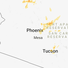


Cities Most Affected by Hail Storms of 8/10/2018
| Hail Size | Demographics of Zip Codes Affected | ||||||
|---|---|---|---|---|---|---|---|
| City | Count | Average | Largest | Pop Density | House Value | Income | Age |
| Milo, MO | 1 | 1.75 | 1.75 | 13 | $43k | $29.5k | 42.2 |
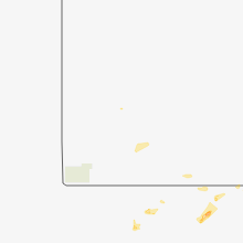
| Seligman, AZ | 1 | 1.75 | 1.75 | 0 | $47k | $22.4k | 53.4 |
| Tucson, AZ | 1 | 1.75 | 1.75 | 100 | $209k | $47.0k | 61.7 |
| Saint Louis, MO | 1 | 1.75 | 1.75 | 1729 | $54k | $34.1k | 32.4 |
| Springfield, MO | 1 | 1.75 | 1.75 | 2488 | $87k | $34.6k | 31.3 |
Hail and Wind Damage Spotted on 8/10/2018
Filter by Report Type:Hail ReportsWind Reports
States Impacted
Oklahoma, Texas, Ohio, Missouri, Mississippi, Kansas, Colorado, Florida, Arizona, Alabama, Georgia, North CarolinaOklahoma
| Local Time | Report Details |
|---|---|
| 2:45 PM CDT | Public reported 60 to 70 mph winds just north of fairfax. time estimate in osage county OK, 50.2 miles NW of Tulsa, OK |
| 3:40 PM CDT | Storm damage reported in osage county OK, 6.7 miles WNW of Tulsa, OK |
| 4:05 PM CDT | Local mesonet measured 70mph wind gusts from the northeas in beckham county OK, 75.4 miles S of Woodward, OK |
Texas
| Local Time | Report Details |
|---|---|
| 2:45 PM CDT | Storm damage reported in hockley county TX, 21.5 miles WNW of Lubbock, TX |
| 3:13 PM CDT | Several large tree limbs down... awning blown off... and some roof damage in downtown atlant in cass county TX, 48.1 miles NNW of Shreveport, LA |
| 4:54 PM CDT | Powerlines down on two cars in crosby on bridge over the san jacinto river. report relayed via local medi in harris county TX, 18.7 miles ENE of Houston, TX |
| 4:55 PM CDT | Storm damage reported in hockley county TX, 21.5 miles WNW of Lubbock, TX |
Ohio
| Local Time | Report Details |
|---|---|
| 3:58 PM EDT | One tree downe in fairfield county OH, 23 miles ESE of Columbus, OH |
| 4:33 PM EDT | One tree downe in fairfield county OH, 21.7 miles SE of Columbus, OH |
| 4:45 PM EDT | Trees reported down east and west of somerset along us 2 in perry county OH, 38.8 miles ESE of Columbus, OH |
| 5:30 PM EDT | *** 1 inj *** a tree branch was downed and caused minor injuries to an individual on a canoe. information relayed by miami township fire and em in clermont county OH, 12.1 miles ENE of Cincinnati, OH |
Missouri
| Local Time | Report Details |
|---|---|
| 4:05 PM CDT | Golf Ball sized hail reported near Saint Louis, MO, 12 miles NW of Saint Louis, MO, report from media of law enforcement reported golf ball size hail near lambert airport near interstate 70. |
| 4:11 PM CDT | Multiple trees down in town. time estimated by rada in st. clair county MO, 69.7 miles SSE of Kansas City, MO |
| 4:32 PM CDT | Trees down. power lines down. damage to outbuilding. estimated 60 mph wind in st. clair county MO, 68.6 miles NNW of Springfield, MO |
| 5:17 PM CDT | Telephone pole down on highway v. timing estimated by rada in polk county MO, 42.7 miles NNW of Springfield, MO |
| 5:25 PM CDT | Trees down just west of the intersection of hwy 123 and 13 to the southwest of humansvill in polk county MO, 41.2 miles NNW of Springfield, MO |
| 6:40 PM CDT | Picture via social media of a 2-3 foot diameter tree uprooted in downtown ozar in christian county MO, 13.8 miles SSE of Springfield, MO |
| 6:47 PM CDT | Pictures relayed via media partner of a large tree that fell on a building at a wedding pavilion. timing estimated from rada in christian county MO, 21 miles SE of Springfield, MO |
| 6:47 PM CDT | Pictures relayed via media partner of a large tree that fell on a building at a wedding pavilion. timing estimated from rada in douglas county MO, 27.6 miles SE of Springfield, MO |
| 7:09 PM CDT | Pictures relayed via media contact of large trees fallen on garages... vehicle and road at ava country club. timing estimated from rada in douglas county MO, 37.7 miles ESE of Springfield, MO |
| 7:12 PM CDT | Corrects previous tstm wnd dmg report from ava. picture relayed via ham radio operator of large tree down across road on johnson ave in av in douglas county MO, 39.2 miles ESE of Springfield, MO |
| 7:12 PM CDT | Corrects previous tstm wnd dmg report from 4 w ava. picture relayed via ham radio operator of top of 3-plus inch tree broken off near hwy 5 and hwy y west of ava. timin in douglas county MO, 35.3 miles ESE of Springfield, MO |
| 7:15 PM CDT | Ava skywarn ham radio operator relayed picture of uprooted tree against the high school in av in douglas county MO, 39.2 miles ESE of Springfield, MO |
| 7:18 PM CDT | Quarter sized hail reported near Springfield, MO, 2.1 miles SSW of Springfield, MO, media contact reports quarter size hail and small tree limbs down at ky3 studio off of sunshine street. |
| 7:19 PM CDT | Golf Ball sized hail reported near Milo, MO, 64.5 miles NW of Springfield, MO, public report of golf ball size hail 4 miles east of milo was relayed via amateur radio operator. timing estimated from radar. |
| 7:35 PM CDT | Golf Ball sized hail reported near Springfield, MO, 2.2 miles SSW of Springfield, MO, spotter report of up to golf ball size hail along kansas expressway from battlefield road to sunshine street. timing estimated from radar. |
| 7:35 PM CDT | Numerous reports of large trees and branches down in western and southern springfield. some tree damage to houses... as well. timing estimated from rada in greene county MO, 2.5 miles SW of Springfield, MO |
| 7:37 PM CDT | Emergency manager reports multiple trees and limbs down around willard. timing estimated from rada in greene county MO, 9.1 miles NW of Springfield, MO |
| 7:40 PM CDT | Picture via social media of multiple 4-6 inch tree branches down near the intersection of e guinevere street and s king ave. timing estimated from rada in greene county MO, 3.4 miles S of Springfield, MO |
| 7:47 PM CDT | 36" diameter tree fell through roof of home on w farm road 18 in greene county MO, 6.5 miles SSW of Springfield, MO |
Mississippi
| Local Time | Report Details |
|---|---|
| 4:30 PM CDT | Numerous trees downed around crystal springs including near the intersection of hwy 51 and county line road... south pat harrison drive and earl night roa in copiah county MS, 23.7 miles SSW of Jackson, MS |
Kansas
| Local Time | Report Details |
|---|---|
| 5:00 PM CDT | Ping Pong Ball sized hail reported near Yates Center, KS, 26.8 miles NW of Chanute, KS |
| 5:13 PM CDT | Quarter sized hail reported near Yates Center, KS, 25.6 miles NW of Chanute, KS |
| 6:25 PM CDT | 60 mph winds in town. relayed via ksn-t in sedgwick county KS, 8.1 miles S of Wichita, KS |
Colorado
| Local Time | Report Details |
|---|---|
| 4:11 PM MDT | Asos station mtj... montrose rgnl airpor in montrose county CO, 53 miles SE of Grand Junction, CO |
Florida
| Local Time | Report Details |
|---|---|
| 6:11 PM EDT | The au497 elevated observing station reported a 52 kt/60 mph wind gust at 611 pm edt. the observing station is 393 feet above the surfac in amz651 county FL, 26.3 miles NNE of Miami, FL |
| 6:20 PM CDT | Fire caused by downed power line at gillman rd... westville... fl 3246 in holmes county FL, 43 miles NNE of Miramar Beach, FL |
Arizona
| Local Time | Report Details |
|---|---|
| 3:45 PM MST | Quarter sized hail reported near Tucson, AZ, 18 miles N of Tucson, AZ, cocorahs report of 1" hail north of oro valley. |
| 4:00 PM MST | Golf Ball sized hail reported near Tucson, AZ, 18 miles N of Tucson, AZ, spotter estimated golf ball size with 2" of rainfall measured in the last hour. |
| 7:30 PM MST | Golf Ball sized hail reported near Seligman, AZ, 73 miles W of Flagstaff, AZ |
Alabama
| Local Time | Report Details |
|---|---|
| 6:28 PM CDT | Tree down on county road 43 in coffee county AL, 66.2 miles N of Miramar Beach, FL |
| 6:28 PM CDT | Tree down on county road 47 in coffee county AL, 59.5 miles NNE of Miramar Beach, FL |
| 6:28 PM CDT | Tree down on county road 40 in coffee county AL, 68.2 miles N of Miramar Beach, FL |
| 6:43 PM CDT | A tree down near elba... a in coffee county AL, 73.9 miles NNE of Miramar Beach, FL |
| 7:20 PM CDT | Large tree limbs were blown down in the greenwood communit in jefferson county AL, 15.7 miles SSW of Birmingham, AL |
| 7:20 PM CDT | A few trees were blown down on lou george loop roa in jefferson county AL, 18.7 miles SW of Birmingham, AL |
| 7:22 PM CDT | Trees were blown down near highway 52 and elvira roa in shelby county AL, 16.5 miles SSW of Birmingham, AL |
| 7:25 PM CDT | Tree down on scurlock roa in shelby county AL, 17.4 miles S of Birmingham, AL |
| 7:42 PM CDT | Trees were blown down near weatherly club drive. numerous other reports of large tree limbs and power lines blown down in alabaster... pelham... and helen in shelby county AL, 18.6 miles S of Birmingham, AL |
Georgia
| Local Time | Report Details |
|---|---|
| 7:50 PM EDT | Multiple trees down reported at amboy-rebecca rd... georgi in turner county GA, 46 miles WNW of Douglas, GA |
| 8:10 PM EDT | Multiple trees and a power line down reported at tempy... g in worth county GA, 57.4 miles W of Douglas, GA |
| 8:12 PM EDT | A tree down on chula brookfield rd one mile east of 1-7 in tift county GA, 40.3 miles W of Douglas, GA |
North Carolina
| Local Time | Report Details |
|---|---|
| 1:27 AM EDT | Quarter sized hail reported near Star, NC, 59.2 miles ENE of Charlotte, NC, report received via social media page. |
Connect with Interactive Hail Maps