

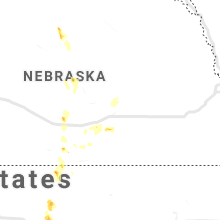
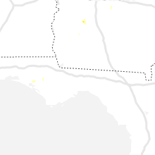
Hail Map for Saturday, August 14, 2021

Number of Impacted Households on 8/14/2021
0
Impacted by 1" or Larger Hail
0
Impacted by 1.75" or Larger Hail
0
Impacted by 2.5" or Larger Hail
Square Miles of Populated Area Impacted on 8/14/2021
0
Impacted by 1" or Larger Hail
0
Impacted by 1.75" or Larger Hail
0
Impacted by 2.5" or Larger Hail


Cities Most Affected by Hail Storms of 8/14/2021
| Hail Size | Demographics of Zip Codes Affected | ||||||
|---|---|---|---|---|---|---|---|
| City | Count | Average | Largest | Pop Density | House Value | Income | Age |
| Bayard, NE | 3 | 2.50 | 3.00 | 5 | $52k | $30.8k | 43.5 |
| Alliance, NE | 3 | 2.25 | 2.50 | 10 | $73k | $39.4k | 40.8 |
| Rapid City, SD | 3 | 2.08 | 2.50 | 111 | $119k | $47.4k | 44.3 |
| Alexandria, VA | 1 | 4.60 | 4.60 | 3896 | $190k | $78.2k | 38.3 |
| Hemingford, NE | 2 | 2.13 | 2.50 | 1 | $56k | $34.0k | 45.7 |
| Owanka, SD | 1 | 2.75 | 2.75 | 1 | $125k | $80.0k | 43.8 |
| Hermosa, SD | 1 | 2.00 | 2.00 | 3 | $127k | $35.4k | 44.4 |
| Cheyenne, WY | 1 | 1.75 | 1.75 | 26 | $135k | $54.6k | 42.7 |
| Elsie, NE | 1 | 1.75 | 1.75 | 1 | $36k | $40.4k | 46.2 |
| Ellsworth, NE | 1 | 1.75 | 1.75 | 1 | $13k | $31.3k | 43.3 |
| Keystone, SD | 1 | 1.75 | 1.75 | 9 | $97k | $31.4k | 50.6 |
Hail and Wind Damage Spotted on 8/14/2021
Filter by Report Type:Hail ReportsWind Reports
States Impacted
Nebraska, Massachusetts, North Carolina, Virginia, South Carolina, Maine, Alabama, South Dakota, Florida, Texas, Tennessee, Kentucky, Arizona, Wyoming, Utah, Maryland, KansasNebraska
| Local Time | Report Details |
|---|---|
| 6:13 AM MDT | Quarter sized hail reported near Ogallala, NE, 46.3 miles W of North Platte, NE, report via mping. |
| 8:06 AM MDT | Half Dollar sized hail reported near Elsie, NE, 41.8 miles SW of North Platte, NE, size ranged from nickel to half dollar. no significant wind. time estimated from radar. |
| 8:12 AM MDT | Golf Ball sized hail reported near Elsie, NE, 43.6 miles SW of North Platte, NE, delayed report. time estimated from radar. |
| 8:49 AM MDT | Quarter sized hail reported near Madrid, NE, 40.6 miles WSW of North Platte, NE, time estimated from radar. hail lasted approximately 5 minutes. 1.20 inch of rain as of time of phone call and still raining lightly. |
| 8:56 AM MDT | Quarter sized hail reported near Elsie, NE, 43 miles SW of North Platte, NE, time estimated from radar. hail lasted approximately 5 to 6 minutes. |
| 4:10 PM MDT | Half Dollar sized hail reported near Crawford, NE, 58 miles N of Scottsbluff, NE |
| 4:16 PM MDT | Quarter sized hail reported near Crawford, NE, 58.6 miles NNE of Scottsbluff, NE |
| 4:23 PM MDT | Ping Pong Ball sized hail reported near Crawford, NE, 58.6 miles NNE of Scottsbluff, NE |
| 4:30 PM MDT | Quarter sized hail reported near Gordon, NE, 86.5 miles WSW of Valentine, NE, hailed for about 15 minutes. |
| 4:59 PM MDT | Half Dollar sized hail reported near Crawford, NE, 45.8 miles NNE of Scottsbluff, NE |
| 5:09 PM MDT | Golf Ball sized hail reported near Hemingford, NE, 35 miles NNE of Scottsbluff, NE |
| 5:18 PM MDT | Ping Pong Ball sized hail reported near Hemingford, NE, 35 miles NNE of Scottsbluff, NE |
| 5:35 PM MDT | Tennis Ball sized hail reported near Hemingford, NE, 32.4 miles NE of Scottsbluff, NE, delayed report. received via twitter. |
| 5:35 PM MDT | Golf Ball sized hail reported near Ellsworth, NE, 84.4 miles ENE of Scottsbluff, NE, report via facebook |
| 6:06 PM MDT | Golf Ball sized hail reported near Alliance, NE, 21.9 miles NE of Scottsbluff, NE |
| 6:10 PM MDT | Tennis Ball sized hail reported near Alliance, NE, 20 miles ENE of Scottsbluff, NE |
| 6:15 PM MDT | Tennis Ball sized hail reported near Alliance, NE, 21.8 miles ENE of Scottsbluff, NE |
| 6:31 PM MDT | Hen Egg sized hail reported near Bayard, NE, 24.3 miles ENE of Scottsbluff, NE |
| 6:38 PM MDT | Tennis Ball sized hail reported near Bayard, NE, 21.2 miles E of Scottsbluff, NE |
| 6:38 PM MDT | Tea Cup sized hail reported near Bayard, NE, 21.2 miles E of Scottsbluff, NE |
| 7:30 PM MDT | Half Dollar sized hail reported near Oshkosh, NE, 75 miles ESE of Scottsbluff, NE |
| 7:30 PM MDT | Ping Pong Ball sized hail reported near Oshkosh, NE, 73.6 miles ESE of Scottsbluff, NE, picture of large hailstones to ping pong ball size via facebook northwest of oshkosh. |
| 7:37 PM MDT | Half Dollar sized hail reported near Oshkosh, NE, 74.3 miles ESE of Scottsbluff, NE, half dollar size hail and 46 mph winds. |
| 7:42 PM MDT | Ping Pong Ball sized hail reported near Bridgeport, NE, 30.4 miles SE of Scottsbluff, NE |
| 8:05 PM MDT | Quarter sized hail reported near Oshkosh, NE, 77.7 miles ESE of Scottsbluff, NE |
| 6:26 AM CDT | Half Dollar sized hail reported near Hastings, NE, 22.6 miles S of Grand Island, NE, corrects previous hail report for time of report from 1 nw hastings. a few stones mixed in with rain. |
| 6:26 AM CDT | Ping Pong Ball sized hail reported near Hastings, NE, 22.6 miles S of Grand Island, NE, corrects previous hail report for time of report and size from 1 nw hastings. a few stones mixed in with rain. |
| 6:34 AM CDT | Half Dollar sized hail reported near Hastings, NE, 22.6 miles S of Grand Island, NE, a few stones mixed in with rain. |
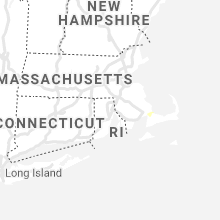
Massachusetts
| Local Time | Report Details |
|---|---|
| 12:15 PM EDT | 2 large limbs down on puritan road at wall st in barnstable county MA, 41.9 miles E of Providence, RI |
| 12:15 PM EDT | 2 large limbs down on puritan road at wall st in barnstable county MA, 41.9 miles E of Providence, RI |
| 12:22 PM EDT | Many large branches down on sandwich road at ben abbey drive. large branches were also down on wires on tyler driv in barnstable county MA, 47.3 miles E of Providence, RI |
North Carolina
| Local Time | Report Details |
|---|---|
| 2:35 PM EDT | A tree was reported down at highway 64 west near zebulon. time estimated by rada in wake county NC, 18.4 miles E of Raleigh, NC |
| 2:59 PM EDT | Public reported large trees down and a demolished shed on eva ct in lincoln county NC, 31.9 miles NW of Charlotte, NC |
| 3:00 PM EDT | Trees and power lines down on sharon road wes in mecklenburg county NC, 7.3 miles SSW of Charlotte, NC |
| 3:08 PM EDT | A tree was reported down near the intersection of fall line ct and old creedmoor rd. time estimated by rada in wake county NC, 9.6 miles NNW of Raleigh, NC |
| 3:09 PM EDT | A tree was reported down near the intersection of n falls dr and creedmoor rd. time estimated by rada in wake county NC, 10.2 miles NNW of Raleigh, NC |
| 3:10 PM EDT | A tree was reported down near the intersection of norwood rd and mt. vernon church rd. time estimated by rada in wake county NC, 10.8 miles N of Raleigh, NC |
| 3:10 PM EDT | A tree was reported down on melvin arnold rd. time estimated by rada in wake county NC, 13 miles NNW of Raleigh, NC |
| 3:36 PM EDT | A large tree was reported down near the intersection of avent ferry rd and center hill dr. the road is closed between center hill dr and new hill holleman rd. time esti in wake county NC, 18 miles SW of Raleigh, NC |
| 3:48 PM EDT | Quarter sized hail reported near Morrisville, NC, 10.6 miles NW of Raleigh, NC, public reports up to quarter sized hail at the raleigh durham international airport. time estimated by radar. |
| 4:15 PM EDT | Trees down near cuthbertson rd & s providence r in union county NC, 18.6 miles SSE of Charlotte, NC |
| 4:25 PM EDT | Emergency mngr reported trees down on tabor r in iredell county NC, 52.2 miles N of Charlotte, NC |
| 4:25 PM EDT | Emergency mngr reported trees down on stack rd in iredell county NC, 50.9 miles N of Charlotte, NC |
| 4:25 PM EDT | Emergency mngr reported trees down on powell bridge rd in iredell county NC, 51.7 miles N of Charlotte, NC |
| 4:35 PM EDT | Emergency mngr reported trees down on fairmount rd in iredell county NC, 46.7 miles N of Charlotte, NC |
| 4:35 PM EDT | Broadcast media reported multiple trees and powerlines down along frank whisnant r in burke county NC, 61.6 miles SSE of Bristol, TN |
| 4:35 PM EDT | Emergency mngr reported power lines down in iredell county NC, 47.4 miles N of Charlotte, NC |
| 4:40 PM EDT | Fire dept reported powerlines down on tomlin mill r in iredell county NC, 48.1 miles N of Charlotte, NC |
| 4:45 PM EDT | Quarter sized hail reported near Marion, NC, 64.9 miles SSE of Bristol, TN, broadcast media reported quarter (1.00") size hail on glenwood ave. |
| 4:45 PM EDT | Fire dept reported rv flipped over on i77 at tomlin mill r in iredell county NC, 48.1 miles N of Charlotte, NC |
| 4:45 PM EDT | Trees and power lines down on on calico r in caldwell county NC, 61.3 miles NW of Charlotte, NC |
| 4:50 PM EDT | 911 call center reported trees and power lines down on clarks chapel r in caldwell county NC, 59.2 miles NW of Charlotte, NC |
| 4:56 PM EDT | Tree down and across shore rd.... near beaver dam l in forsyth county NC, 74 miles NNE of Charlotte, NC |
| 5:00 PM EDT | Fire dept reported trees down on lentz rd in iredell county NC, 47.4 miles N of Charlotte, NC |
| 5:00 PM EDT | Emergency mngr reported trees down on sugar hill r in mcdowell county NC, 64.8 miles NNE of Greenville, SC |
| 5:00 PM EDT | Emergency mngr reported a barn was destroyed and trees dow in iredell county NC, 47.5 miles N of Charlotte, NC |
| 5:05 PM EDT | Emergency mngr reported trees down on old us hwy 221 in mcdowell county NC, 65.9 miles NNE of Greenville, SC |
| 5:13 PM EDT | Tree down at knob view dr. and mountain view rd n in forsyth county NC, 66.7 miles NNE of Charlotte, NC |
| 5:15 PM EDT | A couple of trees down on country club rd. between queensbury rd. and ryandale r in forsyth county NC, 65.4 miles NNE of Charlotte, NC |
| 5:17 PM EDT | Tree down at bentley ct. and westhaven ci in forsyth county NC, 66.8 miles NNE of Charlotte, NC |
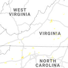
Virginia
| Local Time | Report Details |
|---|---|
| 2:40 PM EDT | Multiple reports of trees dow in buckingham county VA, 50 miles W of Richmond, VA |
| 2:40 PM EDT | Trees dow in buckingham county VA, 51.7 miles W of Richmond, VA |
| 2:55 PM EDT | Tree dow in buckingham county VA, 46.1 miles W of Richmond, VA |
| 4:13 PM EDT | Powerline knocked dow in prince edward county VA, 43 miles WSW of Richmond, VA |
| 4:15 PM EDT | Tree knocked down along us- in caroline county VA, 33.9 miles NNE of Richmond, VA |
| 4:23 PM EDT | Tree knocked dow in prince edward county VA, 41.4 miles WSW of Richmond, VA |
| 4:44 PM EDT | Several trees down on wires between locust grove and unionville causing several traffic light outage in orange county VA, 56.7 miles N of Richmond, VA |
| 5:15 PM EDT | Numerous power outages; wind gust 46 mph at crewe airpor in nottoway county VA, 34.5 miles SW of Richmond, VA |
| 5:16 PM EDT | Tree fell on vehicle. no injurie in charlotte county VA, 63.2 miles SW of Richmond, VA |
| 5:25 PM EDT | Tree downed and partially blocking samaria ln at lott cary rd (va-602). numerous power outages reported on the are in charles city county VA, 29.4 miles ESE of Richmond, VA |
| 5:50 PM EDT | Tree down blocking roa in charlotte county VA, 65.6 miles SW of Richmond, VA |
| 6:00 PM EDT | Wires down resulting in a power outage. time estimated from radar. additional wires areas of wires down were also reported across the count in james city county VA, 51.5 miles ESE of Richmond, VA |
| 6:00 PM EDT | Trees down across swanns point rd near camp pipsic in surry county VA, 48 miles ESE of Richmond, VA |
| 6:05 PM EDT | Tree dow in wythe county VA, 64.2 miles WSW of Roanoke, VA |
| 6:10 PM EDT | Tree dow in wythe county VA, 63.9 miles ENE of Bristol, TN |
| 6:22 PM EDT | Powerlines knocked down resulting in a power outage. time estimated from rada in isle of wight county VA, 30 miles WNW of Virginia Beach, VA |
| 6:25 PM EDT | Trees down and widespread power outage in prince george county VA, 36.9 miles ESE of Richmond, VA |
| 6:35 PM EDT | Wires down near the intersection of va-810 white hall road and rockery plac in albemarle county VA, 69.8 miles NW of Richmond, VA |
| 6:35 PM EDT | Large tree down at a residence near the intersection of millstream drive and millburn cour in albemarle county VA, 69.9 miles NW of Richmond, VA |
| 6:39 PM EDT | A tree was down along route 250 near the intersection of interstate 6 in albemarle county VA, 69.6 miles WNW of Richmond, VA |
| 6:40 PM EDT | Tree down near the intersection of us-250 rockfish gap turnpike and va-797 hillsboro lan in albemarle county VA, 69.6 miles WNW of Richmond, VA |
| 6:40 PM EDT | Roof lifted off a house under construction causing top floor wall collapse in the 1000 block of heathercroft lan in albemarle county VA, 69.5 miles NW of Richmond, VA |
| 6:40 PM EDT | Wires down near the intersection of va-684 half mile branch road and harvest farms lan in albemarle county VA, 70 miles WNW of Richmond, VA |
| 6:57 PM EDT | There were about 100 calls for downed trees and wires in the crozet to north garden area of albemarle county. some homes lost siding and shingles or had minor porch rai in albemarle county VA, 64.1 miles WNW of Richmond, VA |
| 7:00 PM EDT | Large tree branches downed onto bank st. in windsor. power outages reported in the area. time is radar estimate in isle of wight county VA, 38.5 miles W of Virginia Beach, VA |
| 7:05 PM EDT | Powerline knocked down resulting in a power outage. time estimated from rada in prince george county VA, 30.9 miles SSE of Richmond, VA |
| 7:05 PM EDT | Tree down in the 4300 block of us-29 monacan trail roa in albemarle county VA, 63.6 miles WNW of Richmond, VA |
| 7:11 PM EDT | Tree on wires near the intersection of us-29 monacan trail road and lackey lan in albemarle county VA, 63.8 miles WNW of Richmond, VA |
| 7:20 PM EDT | Trees down and power issues throughout the cit in city of suffolk county VA, 29.5 miles W of Virginia Beach, VA |
| 7:30 PM EDT | Tree down near the intersection of va-800 schuyler road and va-808 gold mine lan in nelson county VA, 60.5 miles WNW of Richmond, VA |
| 7:30 PM EDT | Multiple reports of trees down... at least a dozen in addition to powerline in pulaski county VA, 49 miles WSW of Roanoke, VA |
| 7:35 PM EDT | A tree was down along rockfish river road near schuyle in nelson county VA, 60.8 miles WNW of Richmond, VA |
| 2:08 AM EDT | Softball sized hail reported near Alexandria, VA, 45.7 miles SW of Baltimore, MD |
South Carolina
| Local Time | Report Details |
|---|---|
| 3:09 PM EDT | Emergency mngr reported tree down on a house on sweetgum dr in york county SC, 11.5 miles SSW of Charlotte, NC |
| 3:15 PM EDT | 911 call center reported trees and powerlines down on osborne st in union county SC, 55 miles SW of Charlotte, NC |
| 3:15 PM EDT | 911 call center reported a tree down on a home on beltline rd in union county SC, 56.3 miles SW of Charlotte, NC |
| 3:19 PM EDT | Emergency mngr reported tree down on a house on creek bluff r in york county SC, 19.3 miles SW of Charlotte, NC |
| 3:20 PM EDT | Public reported large tree limbs down on hart s in union county SC, 56.5 miles E of Greenville, SC |
| 3:30 PM EDT | Public reported trees down on lake wylie dr at ebenezer par in york county SC, 18.1 miles SW of Charlotte, NC |
| 3:41 PM EDT | Emergency mngr reported trees down on morgan s in york county SC, 16 miles SSW of Charlotte, NC |
| 3:41 PM EDT | Emergency mngr reported trees down on blue jay pas in york county SC, 12.4 miles SW of Charlotte, NC |
| 3:53 PM EDT | Amateur radio reported tree down on a house on malvern r in york county SC, 20.5 miles SSW of Charlotte, NC |
| 5:12 PM EDT | Newberry co sheriffs office reports tree down on whitmire hwy and beth eden r in newberry county SC, 63.8 miles ESE of Greenville, SC |
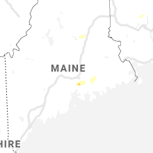
Maine
| Local Time | Report Details |
|---|---|
| 3:10 PM EDT | Corrects previous non-tstm wnd dmg report from 2 sw thomaston. tree down blocking river rd in cushing. time estimated from rada in knox county ME, 55.6 miles SSW of Bangor, ME |
| 3:12 PM EDT | Law enforcement from bucksport reported several trees down on turkey path road. a shed was destroyed by a lightning strik in hancock county ME, 16 miles S of Bangor, ME |
Alabama
| Local Time | Report Details |
|---|---|
| 2:14 PM CDT | Tree damage and damage to a barn reported near county road 56 and county road 9 in henry county AL, 82.2 miles S of Auburn, AL |
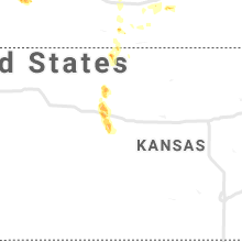
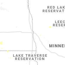
South Dakota
| Local Time | Report Details |
|---|---|
| 1:20 PM MDT | Quarter sized hail reported near Fairburn, SD, 31.3 miles S of Rapid City, SD, dime to nickel hail. |
| 1:35 PM MDT | Quarter sized hail reported near Buffalo Gap, SD, 39.1 miles S of Rapid City, SD, ground is white from the hail |
| 2:10 PM MDT | Quarter sized hail reported near Oral, SD, 49.9 miles S of Rapid City, SD |
| 2:25 PM MDT | Quarter sized hail reported near Rapid City, SD, 8.5 miles W of Rapid City, SD, nickel to quarter hail |
| 2:33 PM MDT | Quarter sized hail reported near Rapid City, SD, 6.8 miles SW of Rapid City, SD |
| 2:38 PM MDT | Golf Ball sized hail reported near Rapid City, SD, 6.8 miles SW of Rapid City, SD |
| 2:40 PM MDT | Quarter sized hail reported near Rapid City, SD, 9.1 miles SSW of Rapid City, SD |
| 2:40 PM MDT | Hen Egg sized hail reported near Rapid City, SD, 9.5 miles SSW of Rapid City, SD |
| 2:49 PM MDT | Tennis Ball sized hail reported near Rapid City, SD, 9.5 miles SSW of Rapid City, SD, no rain |
| 3:15 PM MDT | Golf Ball sized hail reported near Keystone, SD, 15.7 miles SSW of Rapid City, SD, hail lasted 15-20 minutes. began around 315 pm and ended 330 pm. |
| 3:15 PM MDT | Quarter sized hail reported near New Underwood, SD, 27.2 miles ENE of Rapid City, SD |
| 3:25 PM MDT | Quarter sized hail reported near Hermosa, SD, 18.1 miles S of Rapid City, SD |
| 3:30 PM MDT | Baseball sized hail reported near Owanka, SD, 34.4 miles ENE of Rapid City, SD, lots of damage to vehicles. hail began around 330 pm and continued until 345 pm. |
| 3:40 PM MDT | Ping Pong Ball sized hail reported near Owanka, SD, 34.4 miles ENE of Rapid City, SD |
| 3:46 PM MDT | Hen Egg sized hail reported near Hermosa, SD, 22.9 miles S of Rapid City, SD |
| 4:20 PM MDT | Ping Pong Ball sized hail reported near Wall, SD, 54.2 miles ENE of Rapid City, SD |
| 4:50 PM MDT | Half Dollar sized hail reported near Quinn, SD, 64.4 miles ENE of Rapid City, SD, quarter to half dollar sized hail |
| 6:50 PM CDT | Quarter sized hail reported near White River, SD, 53.2 miles SSW of Pierre, SD, still hailing |
| 5:57 PM MDT | Quarter sized hail reported near Fort Pierre, SD, 10.4 miles W of Pierre, SD |
| 6:00 PM MDT | Ping Pong Ball sized hail reported near Oelrichs, SD, 59.5 miles S of Rapid City, SD, pea hail to ping pong ball sized... irregular shape. |
| 6:25 PM MDT | Quarter sized hail reported near Oelrichs, SD, 67 miles S of Rapid City, SD, dime to quarter hail |
| 7:40 PM MDT | Ping Pong Ball sized hail reported near Ridgeview, SD, 53.5 miles N of Pierre, SD |
Florida
| Local Time | Report Details |
|---|---|
| 4:50 PM EDT | An online news outlet posted a picture of wind damage to a carport attached to a mobile home near the intersection of buena vista lane and kepner drive in holida in pasco county FL, 48.2 miles NNW of Bradenton, FL |
| 4:42 PM CDT | Report from mping: 1-inch tree limbs broken; shingles blown of in bay county FL, 36.6 miles E of Miramar Beach, FL |
| 9:01 PM EDT | A southeast wind gust of 50 kts... or 58 mph... was recorded by the weatherflow mesonet at smith shoal light at 901 pm edt. winds were sustained at 34 kts... or 39 mp in gmz033 county FL, 13.5 miles NW of Key West, FL |
Texas
| Local Time | Report Details |
|---|---|
| 4:55 PM CDT | Several large branches and limbs were blown down in the area onto roadways... but cleared away by residents or driver in panola county TX, 49.4 miles SW of Shreveport, LA |
Tennessee
| Local Time | Report Details |
|---|---|
| 6:45 PM EDT | 1 tree down in roadwa in claiborne county TN, 32.7 miles NNE of Knoxville, TN |
| 7:41 PM EDT | Tree down across fordtown r in knox county TN, 5 miles ESE of Knoxville, TN |
| 7:50 PM EDT | Trees down along carters valley rd. time estimated by rada in hawkins county TN, 21.6 miles W of Bristol, TN |
| 8:11 PM EDT | Tree blocking entire road at cross of kodak and midway r in knox county TN, 12.9 miles E of Knoxville, TN |
| 8:15 PM EDT | Tree down over power lines blocking entire road at echodale and stone r in knox county TN, 2.4 miles SSE of Knoxville, TN |
| 8:15 PM EDT | Tree down on power lines blocking roa in knox county TN, 1.9 miles ESE of Knoxville, TN |
| 8:26 PM EDT | Tree down in roadway along becky ln and hendron chapel r in knox county TN, 7 miles SE of Knoxville, TN |
| 8:27 PM EDT | Tree down across james white pkwy blocking two lane in knox county TN, 0.9 miles NE of Knoxville, TN |
| 8:29 PM EDT | Tree down blocking both lanes of traffic along hillwood dr near island home av in knox county TN, 1.7 miles E of Knoxville, TN |
| 8:45 PM EDT | Trees blocking road at mcnutt rd and sevierville pik in knox county TN, 3.2 miles ESE of Knoxville, TN |
| 8:51 PM EDT | Tree down blocking both lanes at chapman hwy and fronda l in knox county TN, 2.4 miles SSE of Knoxville, TN |
| 8:55 PM EDT | Tree dow in blount county TN, 26 miles SSW of Knoxville, TN |
| 9:07 PM EDT | Tree down blocking road at sevierville pike and lindy d in knox county TN, 3.5 miles SE of Knoxville, TN |
| 9:33 PM EDT | Tree down near norris fwy and raccoon valley rd blocking one lane of traffi in knox county TN, 9.9 miles NNW of Knoxville, TN |
Kentucky
| Local Time | Report Details |
|---|---|
| 8:17 PM EDT | Few trees down in the bledsoe area near the leslie county line. time estimated by rada in harlan county KY, 62.7 miles SSE of Irvine, KY |
| 9:50 PM EDT | Tree down on hwy 25 near tractor supply. report came in via social media. time estimated by rada in knox county KY, 59 miles S of Irvine, KY |
Arizona
| Local Time | Report Details |
|---|---|
| 5:52 PM MST | Peak wind gust 60 mph measured by hurricane raws. time estimated from radar as storm passed statio in mohave county AZ, 35 miles SE of Saint George, UT |
Wyoming
| Local Time | Report Details |
|---|---|
| 7:05 PM MDT | Quarter sized hail reported near Cheyenne, WY, 45.9 miles E of Laramie, WY |
| 7:10 PM MDT | Golf Ball sized hail reported near Cheyenne, WY, 47.7 miles E of Laramie, WY |
| 7:21 PM MDT | Half Dollar sized hail reported near Cheyenne, WY, 45.1 miles ESE of Laramie, WY |
| 7:25 PM MDT | Quarter sized hail reported near Cheyenne, WY, 46.7 miles ESE of Laramie, WY |
| 7:25 PM MDT | Quarter sized hail reported near Cheyenne, WY, 46.2 miles ESE of Laramie, WY, wind gusts up to 50 mph was also reported with this storm. |
| 7:52 PM MDT | Quarter sized hail reported near Cheyenne, WY, 51.2 miles ESE of Laramie, WY |
Utah
| Local Time | Report Details |
|---|---|
| 7:12 PM MDT | Quarter sized hail reported near Saint George, UT, 2 miles S of Saint George, UT, viewer video submitted to news media with nickel and quarter sized hail reported. |
Maryland
| Local Time | Report Details |
|---|---|
| 10:45 PM EDT | Several trees down across central calvert count in calvert county MD, 50.5 miles S of Baltimore, MD |
| 10:55 PM EDT | Several trees down between la plata and waldor in charles county MD, 52.6 miles SSW of Baltimore, MD |
| 10:55 PM EDT | Trees down near the intersection of md-381 aquasco road at aquasco farm roa in prince georges county MD, 47.4 miles S of Baltimore, MD |
Kansas
| Local Time | Report Details |
|---|---|
| 1:28 AM CDT | Awos report of 66 mph. dispatch reported that the power went ou in cheyenne county KS, 47.4 miles WNW of Colby, KS |
Connect with Interactive Hail Maps