

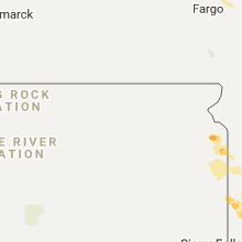
Hail Map for Friday, August 18, 2017

Number of Impacted Households on 8/18/2017
0
Impacted by 1" or Larger Hail
0
Impacted by 1.75" or Larger Hail
0
Impacted by 2.5" or Larger Hail
Square Miles of Populated Area Impacted on 8/18/2017
0
Impacted by 1" or Larger Hail
0
Impacted by 1.75" or Larger Hail
0
Impacted by 2.5" or Larger Hail


Cities Most Affected by Hail Storms of 8/18/2017
| Hail Size | Demographics of Zip Codes Affected | ||||||
|---|---|---|---|---|---|---|---|
| City | Count | Average | Largest | Pop Density | House Value | Income | Age |
| Dover, MO | 1 | 2.00 | 2.00 | 4 | $48k | $43.1k | 47.5 |
| Bigelow, MN | 1 | 2.00 | 2.00 | 7 | $46k | $34.5k | 36.4 |
| Elkins, AR | 1 | 1.75 | 1.75 | 33 | $68k | $32.1k | 37.3 |
| Milbank, SD | 1 | 1.75 | 1.75 | 30 | $67k | $32.6k | 45.2 |
| Primghar, IA | 1 | 1.75 | 1.75 | 10 | $42k | $32.7k | 45.3 |
| Worthington, MN | 1 | 1.75 | 1.75 | 84 | $71k | $36.8k | 34.6 |
Hail and Wind Damage Spotted on 8/18/2017
Filter by Report Type:Hail ReportsWind Reports
States Impacted
Pennsylvania, Minnesota, South Dakota, Maryland, New York, New Jersey, Arkansas, Missouri, Florida, Virginia, Iowa, KansasPennsylvania
| Local Time | Report Details |
|---|---|
| 1:39 PM EDT | Structural damage to a hous in susquehanna county PA, 24.4 miles NNE of Scranton, PA |
| 3:12 PM EDT | Tree down at the 1400 block of old us route 22 in greenwich township. time estimated from rada in berks county PA, 59.1 miles S of Scranton, PA |
| 3:25 PM EDT | Trees down along knight and red top road in dauphin county PA, 67.8 miles N of Baltimore, MD |
| 3:47 PM EDT | Tree down at intersection of saddlebrook drive and daniel street in south heidelberg twp. time estimated from rada in berks county PA, 77 miles SSW of Scranton, PA |
| 4:19 PM EDT | Tree down on wires on the 900 block of old topton road. time estimated from rada in berks county PA, 60 miles S of Scranton, PA |
| 5:25 PM EDT | Downed tree in wires on clover mill road and pikeland road between kimberton road and church road. all lanes are closed. time estimated by rada in chester county PA, 77.2 miles NE of Baltimore, MD |
| 5:40 PM EDT | Several trees dow in chester county PA, 58.2 miles NE of Baltimore, MD |
| 5:54 PM EDT | Creek road at old york road closed from a downed tree in wires. time estimated by rada in bucks county PA, 65.4 miles WSW of Brooklyn, NY |
| 6:15 PM EDT | Public report of high winds and flooding of low water crossings in yardley. time estimated from rada in bucks county PA, 55 miles SW of Brooklyn, NY |
| 6:32 PM EDT | Wires down in several location in bucks county PA, 55.9 miles SW of Brooklyn, NY |
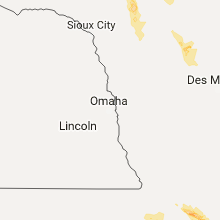
Minnesota
| Local Time | Report Details |
|---|---|
| 12:50 PM CDT | Quarter sized hail reported near Wadena, MN, 67.7 miles S of Bemidji, MN, brief quarter sized hail... then down to dime sized hail |
| 12:50 PM CDT | Quarter sized hail reported near Wadena, MN, 66.6 miles S of Bemidji, MN, brief quarter sized hail... then down to dime sized hail |
| 5:35 PM CDT | Winds gusting to 67 mph in minneota along with pea size hail and torrential rai in lyon county MN, 30.2 miles SSW of Montevideo, MN |
| 5:54 PM CDT | Quarter sized hail reported near Lake Benton, MN, 54.2 miles NNE of Sioux Falls, SD |
| 6:00 PM CDT | Quarter sized hail reported near Lynd, MN, 39.7 miles SSW of Montevideo, MN, quarter size hail and widespread road flooding reported in lynd via social media. |
| 6:25 PM CDT | Trained storm spotter estimated winds gusting to 60 mp in lyon county MN, 51.3 miles S of Montevideo, MN |
| 6:40 PM CDT | Quarter sized hail reported near Sanborn, MN, 62.7 miles SSE of Montevideo, MN |
| 6:45 PM CDT | Quarter sized hail reported near Lake Wilson, MN, 50.1 miles NE of Sioux Falls, SD, pea to quarter size hail. |
| 6:45 PM CDT | Storm damage reported in murray county MN, 50.1 miles NE of Sioux Falls, SD |
| 7:20 PM CDT | Ping Pong Ball sized hail reported near Rushmore, MN, 46.5 miles ENE of Sioux Falls, SD |
| 7:40 PM CDT | Golf Ball sized hail reported near Worthington, MN, 53.3 miles E of Sioux Falls, SD |
| 7:46 PM CDT | Hog barn destroye in nobles county MN, 47 miles E of Sioux Falls, SD |
| 7:55 PM CDT | Hen Egg sized hail reported near Bigelow, MN, 52.4 miles E of Sioux Falls, SD |
South Dakota
| Local Time | Report Details |
|---|---|
| 2:35 PM CDT | Quarter sized hail reported near Milbank, SD, 48.3 miles WNW of Montevideo, MN, no damage apparent at time of call. |
| 2:40 PM CDT | Half Dollar sized hail reported near Milbank, SD, 48.8 miles WNW of Montevideo, MN, report relayed through social media. |
| 2:42 PM CDT | Golf Ball sized hail reported near Milbank, SD, 49.7 miles WNW of Montevideo, MN, report and video relayed through social media. hail blanketed the entire u.s. highway 12 roadway. |
| 2:50 PM CDT | Mobile mesonet instruments measured the strong wind in grant county SD, 49.2 miles WNW of Montevideo, MN |
| 3:06 PM CDT | Quarter sized hail reported near Milbank, SD, 44.4 miles WNW of Montevideo, MN, radar estimated time. |
| 3:51 PM CDT | Ping Pong Ball sized hail reported near Revillo, SD, 38.9 miles W of Montevideo, MN |
| 4:07 PM CDT | Quarter sized hail reported near Clear Lake, SD, 48 miles W of Montevideo, MN, 61 mph winds and quarter size hail. |
| 4:25 PM CDT | Several object blown about 125 yards including a swing-set and trampoline. estimated winds could have been around 70 mp in deuel county SD, 44.3 miles WSW of Montevideo, MN |
| 4:25 PM CDT | Several object blown about 125 yards including a swing-set and trampoline. estimated winds could have been around 70 mp in deuel county SD, 44.3 miles WSW of Montevideo, MN |
| 4:30 PM CDT | Quarter sized hail reported near Clear Lake, SD, 44.3 miles WSW of Montevideo, MN |
Maryland
| Local Time | Report Details |
|---|---|
| 5:11 PM EDT | Several large trees and limbs down in the 400 block of north hilton stree in baltimore city county MD, 3.2 miles W of Baltimore, MD |
| 5:15 PM EDT | Several reports of trees down in the catonsville are in baltimore county MD, 7.3 miles WSW of Baltimore, MD |
| 5:22 PM EDT | Tree limb down on wires in the 1200 block of elm ridge avenu in baltimore county MD, 4.8 miles WSW of Baltimore, MD |
| 5:22 PM EDT | Large tree down onto vehicle along willys avenue between sulphur spring rd and june rd. no injurie in baltimore county MD, 5.6 miles WSW of Baltimore, MD |
| 5:24 PM EDT | Several large tree branches down along sulphur spring rd between benson ave and railroad trussels in baltimore county MD, 5.1 miles WSW of Baltimore, MD |
| 5:29 PM EDT | Tree limbs down near the arena club in churchvill in harford county MD, 25.6 miles NE of Baltimore, MD |
| 6:00 PM EDT | Numerous large tree limbs down in the 7800 block of estevez roa in charles county MD, 57.6 miles SSW of Baltimore, MD |
| 6:52 PM EDT | Tree down near the intersection of old chapel road and waldorf wa in prince georges county MD, 22.1 miles SSW of Baltimore, MD |
| 7:08 PM EDT | Tree down in broomes island in calvert county MD, 60.2 miles S of Baltimore, MD |
| 7:44 PM EDT | 2 trees down in chaptic in st. marys county MD, 64.2 miles S of Baltimore, MD |
| 7:51 PM EDT | Tree down on power lines near the intersection of new market turner road and hidden valley lan in st. marys county MD, 58.8 miles S of Baltimore, MD |
New York
| Local Time | Report Details |
|---|---|
| 6:05 PM EDT | Tree down on ward street which brought down power line in orange county NY, 58.6 miles NNW of Brooklyn, NY |
| 7:57 PM EDT | Multiple trees down on simpson rd in herkimer county NY, 53.6 miles ENE of Syracuse, NY |
| 7:57 PM EDT | Multiple trees down in road military rd near gauss rd in herkimer county NY, 53.7 miles ENE of Syracuse, NY |
| 7:57 PM EDT | Trees and wires down on dover road in herkimer county NY, 52.8 miles ENE of Syracuse, NY |
| 8:02 PM EDT | Trees and wires down in herkimer county NY, 54.8 miles ENE of Syracuse, NY |
| 8:02 PM EDT | Trees down on military rd near mill rd in herkimer county NY, 55.4 miles ENE of Syracuse, NY |
| 8:02 PM EDT | Multiple trees down on russia road in herkimer county NY, 55.7 miles ENE of Syracuse, NY |
New Jersey
| Local Time | Report Details |
|---|---|
| 6:06 PM EDT | Downed trees and wires in the townshi in hunterdon county NJ, 43.4 miles W of Brooklyn, NY |
| 6:45 PM EDT | Trees down near the waterfront in perth amboy and south amboy. scattered wires and power lines down throughout the count in middlesex county NJ, 21.1 miles SW of Brooklyn, NY |
| 6:45 PM EDT | Downed tree on us 206 between dunns mill road and us 130 intersection. all lanes closed. time estimated from rada in burlington county NJ, 54.3 miles SW of Brooklyn, NY |
| 6:59 PM EDT | Trees down and power outages in mount laurel. time estimated by rada in burlington county NJ, 70.9 miles SW of Brooklyn, NY |
| 7:33 PM EDT | Downed tree on power lines on fort plains road in monmouth county NJ, 36.8 miles SSW of Brooklyn, NY |
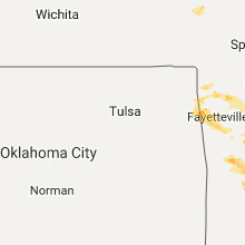
Arkansas
| Local Time | Report Details |
|---|---|
| 5:22 PM CDT | Quarter sized hail reported near Gentry, AR, 61.1 miles N of Fort Smith, AR, social media report. |
| 6:28 PM CDT | Power lines down on howard nickell roa in washington county AR, 50.8 miles N of Fort Smith, AR |
| 6:42 PM CDT | Power poles broken. tree limbs to 3 inches in diameter broke in washington county AR, 49.4 miles NNE of Fort Smith, AR |
| 6:53 PM CDT | Quarter sized hail reported near Fayetteville, AR, 48.8 miles NNE of Fort Smith, AR |
| 6:53 PM CDT | Power lines damaged near morningside drive and 15th street in fayetteville. social media repor in washington county AR, 48.8 miles NNE of Fort Smith, AR |
| 6:55 PM CDT | Ping Pong Ball sized hail reported near Fayetteville, AR, 47 miles NNE of Fort Smith, AR, stonebridge meadows subdivision. |
| 6:55 PM CDT | Half Dollar sized hail reported near Fayetteville, AR, 46.6 miles NNE of Fort Smith, AR |
| 6:56 PM CDT | Extensive tree damage within neighborhood west of i-49 in fayetteville. social media report with pic in washington county AR, 48.8 miles NNE of Fort Smith, AR |
| 7:03 PM CDT | Reports a barn and power poles being blown dow in boone county AR, 74.5 miles S of Springfield, MO |
| 7:13 PM CDT | Nws cooperative observer reports at least one tree blew over in their yard and estimated winds around 60 mp in newton county AR, 76.5 miles S of Springfield, MO |
| 7:13 PM CDT | Golf Ball sized hail reported near Elkins, AR, 48.3 miles NNE of Fort Smith, AR |
| 7:19 PM CDT | Tree branches to 3 inches in diameter broke in washington county AR, 48.3 miles NNE of Fort Smith, AR |
| 7:40 PM CDT | Quarter sized hail reported near Altus, AR, 37.6 miles E of Fort Smith, AR, along i-40 between altus and ozark. |
| 7:55 PM CDT | Trees and power lines were reported down across cottontown road in logan county AR, 44.8 miles E of Fort Smith, AR |
| 8:10 PM CDT | Trees and power lines were reported down and blocking highway 288 and highway 19 in logan county AR, 46.6 miles E of Fort Smith, AR |
| 8:20 PM CDT | Trees and power lines were reported down on highway 22 in midwa in logan county AR, 50.8 miles E of Fort Smith, AR |
| 9:23 PM CDT | Trees were reported down on highway 2 in yell county AR, 53.8 miles ESE of Fort Smith, AR |
Missouri
| Local Time | Report Details |
|---|---|
| 5:34 PM CDT | Tree was blown over onto state highway 3 in barry county MO, 59 miles SW of Springfield, MO |
| 6:45 PM CDT | Ping Pong Ball sized hail reported near Smithville, MO, 18.4 miles N of Kansas City, MO |
| 6:50 PM CDT | Quarter sized hail reported near Independence, MO, 15.3 miles E of Kansas City, MO |
| 6:51 PM CDT | Quarter sized hail reported near Lathrop, MO, 33.7 miles NNE of Kansas City, MO |
| 7:45 PM CDT | Ping Pong Ball sized hail reported near Richmond, MO, 39.4 miles ENE of Kansas City, MO, local media forwarded public report via social media. |
| 8:08 PM CDT | Hen Egg sized hail reported near Dover, MO, 48.3 miles E of Kansas City, MO, delayed report... picture showed approximately 2 inch hail on social media. |
| 9:15 PM CDT | Quarter sized hail reported near Higginsville, MO, 46.5 miles E of Kansas City, MO, dime to quarter sized hail lasted for about 15 minutes starting at 915 pm cdt. |
| 9:20 PM CDT | Half Dollar sized hail reported near Mayview, MO, 40.7 miles E of Kansas City, MO, local media forwarded public report via social media. |
| 9:35 PM CDT | Quarter sized hail reported near Camdenton, MO, 63 miles NNE of Springfield, MO |
| 9:42 PM CDT | Quarter sized hail reported near Knob Noster, MO, 55.7 miles ESE of Kansas City, MO, near the intersection of ne 801st and 700th. |
| 9:44 PM CDT | Half Dollar sized hail reported near Camdenton, MO, 63 miles NNE of Springfield, MO |
| 9:44 PM CDT | Ping Pong Ball sized hail reported near Linn Creek, MO, 65.9 miles NNE of Springfield, MO, ping pong hail picture on social media near linn creek. |
| 9:48 PM CDT | Ping Pong Ball sized hail reported near Warrensburg, MO, 48.4 miles ESE of Kansas City, MO, reported via social media. |
| 10:00 PM CDT | Quarter sized hail reported near Knob Noster, MO, 59.7 miles ESE of Kansas City, MO |
Florida
| Local Time | Report Details |
|---|---|
| 6:35 PM EDT | Emergency manager reports 1 roof damaged on buckingham ct and 1 car port damaged on green road in rockledge. time approximate. possible tornado. re-sent for correctio in brevard county FL, 41.6 miles ESE of Orlando, FL |
| 6:35 PM EDT | Emergency manager reports 1 roof damaged on buckingham ct and 1 car port damaged on green road in rockledge. time approximate. possible tornado. re-sent for correctio in brevard county FL, 41.6 miles ESE of Orlando, FL |
Virginia
| Local Time | Report Details |
|---|---|
| 7:20 PM EDT | Numerous trees down across caroline county primarily in the central and eastern portions of the county. numerous roads blocked by fallen tree in caroline county VA, 40.1 miles NNE of Richmond, VA |
| 7:21 PM EDT | Numerous trees down in sparta with damage to a hom in caroline county VA, 40.7 miles NE of Richmond, VA |
| 7:42 PM EDT | Trees down across northern essex county. reports of wind debris in the road as far south as tappahannoc in essex county VA, 50.3 miles NE of Richmond, VA |
| 7:49 PM EDT | Asos station ofp... hanover county municipa in hanover county VA, 18.4 miles NE of Richmond, VA |
| 8:10 PM EDT | Trees down along highway 360 and mill pond r in richmond county VA, 60.5 miles ENE of Richmond, VA |
| 8:12 PM EDT | Quarter sized hail reported near Warsaw, VA, 58.1 miles ENE of Richmond, VA |
| 8:23 PM EDT | Trees down in southern king william county along highway 3 in king william county VA, 41.4 miles E of Richmond, VA |
| 8:30 PM EDT | Few trees down across the count in new kent county VA, 36.9 miles E of Richmond, VA |
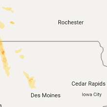
Iowa
| Local Time | Report Details |
|---|---|
| 6:39 PM CDT | Quarter sized hail reported near Wever, IA, 33 miles NE of Kahoka, MO, report via facebook |
| 7:00 PM CDT | Quarter sized hail reported near Burlington, IA, 37.6 miles NE of Kahoka, MO, mixture of dime to quarter size hail. |
| 8:14 PM CDT | Tractor trailer overturned on highway 6 in osceola county IA, 52.7 miles E of Sioux Falls, SD |
| 8:30 PM CDT | Golf Ball sized hail reported near Primghar, IA, 35.3 miles NNW of Storm Lake, IA, broadcast media relay of a public report. |
| 8:41 PM CDT | Quarter sized hail reported near Hartley, IA, 40.2 miles NNW of Storm Lake, IA |
| 8:50 PM CDT | Farmstead damaged. no injurie in osceola county IA, 50.8 miles NNW of Storm Lake, IA |
| 10:38 PM CDT | Quarter sized hail reported near Manson, IA, 36.2 miles ESE of Storm Lake, IA, trained spotter reported quarter sized hail lasting about 3-5 minutes... and some damage to vehicles. |
Kansas
| Local Time | Report Details |
|---|---|
| 7:45 PM CDT | Ping Pong Ball sized hail reported near Richmond, KS, 54.8 miles NNE of Chanute, KS, local media forwarded public report via social media. |
Connect with Interactive Hail Maps