

Hail Map for Monday, August 19, 2019

Number of Impacted Households on 8/19/2019
0
Impacted by 1" or Larger Hail
0
Impacted by 1.75" or Larger Hail
0
Impacted by 2.5" or Larger Hail
Square Miles of Populated Area Impacted on 8/19/2019
0
Impacted by 1" or Larger Hail
0
Impacted by 1.75" or Larger Hail
0
Impacted by 2.5" or Larger Hail


Cities Most Affected by Hail Storms of 8/19/2019
| Hail Size | Demographics of Zip Codes Affected | ||||||
|---|---|---|---|---|---|---|---|
| City | Count | Average | Largest | Pop Density | House Value | Income | Age |
| Agawam, MA | 1 | 2.00 | 2.00 | 1419 | $127k | $45.7k | 45.5 |
| Wray, CO | 1 | 1.75 | 1.75 | 5 | $72k | $33.4k | 39.1 |
| Belfield, ND | 1 | 1.75 | 1.75 | 1 | $38k | $28.4k | 45.6 |
| Feeding Hills, MA | 1 | 1.75 | 1.75 | 1025 | $137k | $55.7k | 42.9 |
Hail and Wind Damage Spotted on 8/19/2019
Filter by Report Type:Hail ReportsWind Reports
States Impacted
New Jersey, Delaware, Alabama, Massachusetts, Georgia, New Hampshire, North Carolina, South Carolina, Pennsylvania, Connecticut, Maine, New York, Virginia, Kansas, Tennessee, Maryland, Texas, Illinois, Colorado, North Dakota, Montana, Minnesota, IowaNew Jersey
| Local Time | Report Details |
|---|---|
| 1:34 PM EDT | Storm damage reported in ocean county NJ, 60.9 miles S of Brooklyn, NY |
| 2:39 PM EDT | Storm damage reported in ocean county NJ, 62.6 miles S of Brooklyn, NY |
| 3:48 PM EDT | Large trees down in the roadway on creek road and also onto some houses between cox road and borton landing road in moorestown. time estimated from rada in burlington county NJ, 67.3 miles SW of Brooklyn, NY |
| 4:00 PM EDT | Trees and poles down on jacksonville road in westampton. time estimated from rada in burlington county NJ, 62.9 miles SW of Brooklyn, NY |
| 4:00 PM EDT | Corrects previous tstm wnd dmg report from 1 n jacksonville. trees and poles down near burlington jacksonville road in westampton. time estimated from rada in burlington county NJ, 60.8 miles SW of Brooklyn, NY |
| 4:03 PM EDT | Numerous trees down in the columbus area especially on jacksonville road. time estimated from rada in burlington county NJ, 58.2 miles SW of Brooklyn, NY |
| 4:04 PM EDT | Tree down onto us 130 both directions approaching south of cr 616/cove road. one lane is closed. time estimated from rada in camden county NJ, 75.8 miles SW of Brooklyn, NY |
| 4:04 PM EDT | Large tree limbs down. time estimated from rada in camden county NJ, 76.2 miles SW of Brooklyn, NY |
| 4:04 PM EDT | Downed trees and power lines near hillside avenue and highland avenue. time estimated from rada in camden county NJ, 77.5 miles SW of Brooklyn, NY |
| 4:10 PM EDT | Wires and some tree limbs down. time estimated from rada in ocean county NJ, 63.2 miles S of Brooklyn, NY |
| 4:13 PM EDT | Wind gusts between 61 and 73 mph. time estimated from rada in camden county NJ, 75.9 miles SW of Brooklyn, NY |
| 4:13 PM EDT | Multiple trees down with street closures from pennsauken to the cherry hill mall. power outages in this area... which are leading to traffic disruptions as well. time e in camden county NJ, 75.9 miles SW of Brooklyn, NY |
| 4:13 PM EDT | Downed trees and power lines near woodland avenue and linden avenue. time estimated from rada in camden county NJ, 76.4 miles SW of Brooklyn, NY |
| 4:14 PM EDT | Spotter estimated 50 kt wind gusts with storm passag in burlington county NJ, 73.5 miles SW of Brooklyn, NY |
| 4:20 PM EDT | Ping Pong Ball sized hail reported near Cherry Hill, NJ, 74.9 miles SW of Brooklyn, NY |
| 4:24 PM EDT | Downed trees and wires near old farm road and sycamore avenue. time estimated from rada in monmouth county NJ, 25.9 miles S of Brooklyn, NY |
| 4:29 PM EDT | Storm damage reported in ocean county NJ, 62 miles S of Brooklyn, NY |
| 4:34 PM EDT | Mping report of large tree limbs snapped and power poles broken. time estimated from rada in burlington county NJ, 71.7 miles SW of Brooklyn, NY |
| 4:37 PM EDT | Tree down in wires with power outages near grassmere avenue and chestnut avenue. time estimated from rada in monmouth county NJ, 31.3 miles S of Brooklyn, NY |
| 4:38 PM EDT | Tree branches and power poles downed in the medford area according to mping. time estimated from rada in burlington county NJ, 71.2 miles SW of Brooklyn, NY |
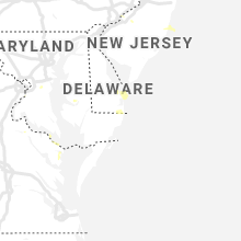
Delaware
| Local Time | Report Details |
|---|---|
| 1:48 PM EDT | 65 knot gust at the lewes buo in anz431 county DE, 30.8 miles N of Ocean City, MD |
| 1:56 PM EDT | Half Dollar sized hail reported near Dewey Beach, DE, 25.2 miles N of Ocean City, MD, corrects previous hail report from 1 nw dewey beach. |
| 1:57 PM EDT | Several social media reports of downed trees across town. time based on social media reports and rada in sussex county DE, 30.8 miles N of Ocean City, MD |
| 2:17 PM EDT | Storm damage reported in sussex county DE, 23.8 miles N of Ocean City, MD |
| 3:36 PM EDT | Half Dollar sized hail reported near Dewey Beach, DE, 25.2 miles N of Ocean City, MD |
| 3:39 PM EDT | Downed wires on fairway drive. time estimated from rada in sussex county DE, 14.2 miles N of Ocean City, MD |
| 4:47 PM EDT | Social media reports of several downed trees between seaford and bridgeville. time estimated from rada in sussex county DE, 36.7 miles NW of Ocean City, MD |
Alabama
| Local Time | Report Details |
|---|---|
| 1:06 PM CDT | Several trees down onto cr 156 in the section area. time estimated by rada in jackson county AL, 48.1 miles SW of Chattanooga, TN |
| 1:29 PM CDT | A tree was knocked down onto a residence in pine ridg in dekalb county AL, 49.1 miles SSW of Chattanooga, TN |
| 1:30 PM CDT | Several trees were blown down along cr 1 in perry county AL, 49.4 miles N of Camden, AL |
| 1:42 PM CDT | Several trees were blown down along highway 5 northeast of mario in perry county AL, 47.3 miles N of Camden, AL |
| 3:00 PM CDT | A tree was blown down and into the roadway on cr 52 north of weiss lak in cherokee county AL, 57.8 miles SSW of Chattanooga, TN |
| 3:06 PM CDT | A large tree and power lines were downed near chestnut and cleveland. winds estimated at 45 mp in etowah county AL, 57.2 miles NE of Birmingham, AL |
| 3:08 PM CDT | A large tree was blown down near mcdonalds on chestnut in attalla. winds estimated at 50 mp in etowah county AL, 54.4 miles NE of Birmingham, AL |
| 3:10 PM CDT | A roof was blown off a building on cleveland ave. winds estimated at 50 mp in etowah county AL, 54.4 miles NE of Birmingham, AL |
| 3:11 PM CDT | A tree has fallen on a home on 6th ave nw. the home was also hit by lightning. winds estimated at 50 mp in etowah county AL, 54 miles NE of Birmingham, AL |
| 4:06 PM CDT | Trees were blown down and a roof was blown off a mobile home along shiver de freeze road in far northern tuscaloosa count in tuscaloosa county AL, 49.1 miles W of Birmingham, AL |
| 5:30 PM CDT | Trees down on hwy 331 in montgomery. fire station had minor roof damage. time estimated. winds estimated 40-50mp in montgomery county AL, 52.3 miles WSW of Auburn, AL |
| 5:55 PM CDT | Ema reports trees down within decatur city limit in morgan county AL, 41.2 miles ESE of Florence, AL |
| 6:41 PM CDT | Trees down along hwy 55 ... northeast of sterrett... al. time estimated by rada in shelby county AL, 20.4 miles E of Birmingham, AL |
| 6:45 PM CDT | Tree down on home in lipscomb. time estimated by rada in jefferson county AL, 9.3 miles SW of Birmingham, AL |
| 6:45 PM CDT | Tree reported down at 400 alexander road. time estimated by rada in shelby county AL, 17.4 miles E of Birmingham, AL |
| 6:46 PM CDT | Trees and power lines down near hwy 480 and hwy 50. time estimated by rada in shelby county AL, 17.6 miles E of Birmingham, AL |
| 6:46 PM CDT | Trees and power lines down. time estimated by rada in shelby county AL, 15.2 miles E of Birmingham, AL |
| 7:00 PM CDT | Numerous trees down along hwy 41 near stonegate drive and connemara trail area. time estimated by rada in shelby county AL, 12.9 miles SE of Birmingham, AL |
| 7:00 PM CDT | Numerous trees and power lines down in bessemer. time estimated by rada in jefferson county AL, 11.5 miles SW of Birmingham, AL |
| 7:00 PM CDT | Trees and power lines down along bear creek road. time estimated by rada in shelby county AL, 15.3 miles ESE of Birmingham, AL |
| 7:08 PM CDT | Trees and power lines down near chelsea rd and foster rd. time estimated by radar and arrival of gust front. winds estimated 40mp in shelby county AL, 21.7 miles SSE of Birmingham, AL |
| 7:15 PM CDT | Tree reported down at 299 linwood road. time estimated by rada in shelby county AL, 13.9 miles SE of Birmingham, AL |
Massachusetts
| Local Time | Report Details |
|---|---|
| 2:16 PM EDT | Trees down on poplar avenue and park avenu in hampden county MA, 67.5 miles WNW of Providence, RI |
| 2:19 PM EDT | Wires down due to tstm wind on suffield stree in hampden county MA, 65.4 miles WNW of Providence, RI |
| 2:20 PM EDT | Tree down on route 5 near bondi's islan in hampden county MA, 63.4 miles WNW of Providence, RI |
| 2:20 PM EDT | Tree down on a house on benedict stree in hampden county MA, 66.8 miles WNW of Providence, RI |
| 2:24 PM EDT | Golf Ball sized hail reported near Feeding Hills, MA, 66 miles WNW of Providence, RI |
| 2:25 PM EDT | Tree down on adams street in front of a car with wires down on top of the ca in hampden county MA, 64.2 miles WNW of Providence, RI |
| 2:37 PM EDT | Hen Egg sized hail reported near Agawam, MA, 64.7 miles WNW of Providence, RI, amatuer radio |
| 2:38 PM EDT | Wires down due to tstm wind on oceola lane and tree down on riverview avenu in hampden county MA, 61.7 miles WNW of Providence, RI |
| 2:40 PM EDT | Wires down due to tstm wind on benedict terrac in hampden county MA, 62.5 miles WNW of Providence, RI |
| 2:40 PM EDT | Tree down on a house on shawmut stree in hampden county MA, 61.2 miles WNW of Providence, RI |
| 2:40 PM EDT | Trees and wires down on commonwealth avenu in hampden county MA, 61.2 miles WNW of Providence, RI |
| 2:40 PM EDT | Tree down on a house on shawmut stree in hampden county MA, 61.2 miles WNW of Providence, RI |
| 2:41 PM EDT | Quarter sized hail reported near Springfield, MA, 62.4 miles WNW of Providence, RI |
| 2:51 PM EDT | Multiple trees and wires down on dwight street with one of the trees on a hous in hampden county MA, 63.8 miles WNW of Providence, RI |
| 3:09 PM EDT | 2 large limbs down on upper church stree in worcester county MA, 52.2 miles NW of Providence, RI |
| 4:04 PM EDT | Tree down on 8 martin road as well as other locations in the town in worcester county MA, 22.9 miles NW of Providence, RI |
| 4:07 PM EDT | Sailboat flipped over due to thunderstorm wind gust on wallum lake in worcester county MA, 22.6 miles NW of Providence, RI |
| 4:20 PM EDT | Tree down at 166 farm street in worcester county MA, 15.9 miles NNW of Providence, RI |
| 4:43 PM EDT | Tree down at 44 ash street in bristol county MA, 11.4 miles NNE of Providence, RI |
| 5:04 PM EDT | Tree and wires down at 34 north worcester street in bristol county MA, 15.6 miles NE of Providence, RI |
| 5:14 PM EDT | Large tree limb down on wires at 162 scotland street in plymouth county MA, 24.5 miles ENE of Providence, RI |
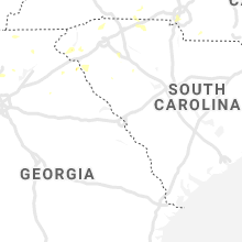
Georgia
| Local Time | Report Details |
|---|---|
| 2:28 PM EDT | A tree was downed on long hollow rd at welcome hill r in chattooga county GA, 32.2 miles S of Chattanooga, TN |
| 2:30 PM EDT | A tree was downed onto airport r in chattooga county GA, 31.5 miles S of Chattanooga, TN |
| 2:30 PM EDT | A tree was downed and blocking halls valley driv in chattooga county GA, 33.6 miles S of Chattanooga, TN |
| 2:30 PM EDT | A tree was downed onto ridgeway drive... blocking the roa in chattooga county GA, 32.8 miles S of Chattanooga, TN |
| 2:36 PM EDT | A few trees down near the intersection of hwy 136 connector and hwy 53 w in pickens county GA, 51.6 miles NNW of Atlanta, GA |
| 2:52 PM EDT | Tree down at 4823 helen hwy in white county GA, 65.3 miles W of Greenville, SC |
| 3:02 PM EDT | Quarter sized hail reported near Calhoun, GA, 46.4 miles SSE of Chattanooga, TN, gordon county ema reported slightly larger than quarter-sized hail at office in calhoun. |
| 3:05 PM EDT | Tree down at hwy 255 n and sky lake rd in white county GA, 60.8 miles W of Greenville, SC |
| 3:10 PM EDT | A tree was downed onto oak hill alpine roa in chattooga county GA, 44 miles S of Chattanooga, TN |
| 3:16 PM EDT | A tree was downed and blocking highway 100 at lyerly dam roa in chattooga county GA, 44 miles S of Chattanooga, TN |
| 3:17 PM EDT | Tree down on lower burris rd near huey barnes ln in cherokee county GA, 39.2 miles N of Atlanta, GA |
| 3:19 PM EDT | Tree down on land rd near hobart smith rd in cherokee county GA, 39.5 miles NNW of Atlanta, GA |
| 3:25 PM EDT | Public report of trees and powerlines down near intersection of miller rd and hunt rd nw... just off hwy 156... west of calhoun. report relayed to nws by ema. time esti in gordon county GA, 41.2 miles SSE of Chattanooga, TN |
| 3:28 PM EDT | A tree was downed on long hollow rd at welcome hill r in chattooga county GA, 32.2 miles S of Chattanooga, TN |
| 3:29 PM EDT | A tree was downed on little refuge roa in cherokee county GA, 39.5 miles NNW of Atlanta, GA |
| 3:50 PM EDT | Power lines were downed and blocking union hill roa in cherokee county GA, 33.2 miles N of Atlanta, GA |
| 3:55 PM EDT | A large tree was downed on east cherokee drive at bart manous roa in cherokee county GA, 31.2 miles N of Atlanta, GA |
| 4:05 PM EDT | A power line was reported down on rabbit hill roa in cherokee county GA, 29.2 miles NNW of Atlanta, GA |
| 4:05 PM EDT | A tree was downed at the intersection of holly springs pkwy and childers r in cherokee county GA, 29.2 miles NNW of Atlanta, GA |
| 4:10 PM EDT | Power lines were downed on park avenue se. time estimated from rada in floyd county GA, 54.2 miles WNW of Atlanta, GA |
| 4:10 PM EDT | Two trees were downed on salem drive n in floyd county GA, 53.6 miles S of Chattanooga, TN |
| 4:10 PM EDT | A tree was downed on pinecrest drive n in floyd county GA, 54.2 miles S of Chattanooga, TN |
| 4:12 PM EDT | Power lines were downed on barker road s in floyd county GA, 53.6 miles S of Chattanooga, TN |
| 4:15 PM EDT | A tree was downed at the instersection of blacks bluff rd sw and livingston rd s in floyd county GA, 59 miles S of Chattanooga, TN |
| 4:20 PM EDT | Power lines were downed at the intersection of fosters mill rd and blacks bluff rd s in floyd county GA, 60.4 miles S of Chattanooga, TN |
| 4:22 PM EDT | Several trees reported down along dunroven way in northern forsyth county. time estimated from rada in forsyth county GA, 44.9 miles NNE of Atlanta, GA |
| 4:24 PM EDT | Several trees down near the intersection of settingdown road and hampton park drive. time estimated from rada in forsyth county GA, 42.3 miles NNE of Atlanta, GA |
| 4:25 PM EDT | Quarter sized hail reported near Lookout Mountain, GA, 5.4 miles SSW of Chattanooga, TN, quarter sized hail was reported at the mapco mart at the corner of mcfarland rd and lula lake rd. |
| 5:57 PM EDT | At least one tree blown dow in hart county GA, 38.1 miles SSW of Greenville, SC |
| 5:57 PM EDT | Quarter sized hail reported near Hartwell, GA, 39 miles SSW of Greenville, SC, hail as large as quarters. |
| 6:35 PM EDT | Large tree uprooted and toppled onto vehicle on pine needle rd in clarke county GA, 58.8 miles ENE of Atlanta, GA |
| 6:42 PM EDT | Trees down along atlanta hwy at the ga-10 loop in clarke county GA, 55.2 miles ENE of Atlanta, GA |
| 6:45 PM EDT | A large tree fell onto power lines near the intersection of sunset drive and edwards d in clarke county GA, 58.3 miles ENE of Atlanta, GA |
New Hampshire
| Local Time | Report Details |
|---|---|
| 2:40 PM EDT | Branches down on road in belknap county NH, 64.9 miles WSW of Portland, ME |
| 3:30 PM EDT | Trees down on water stree in rockingham county NH, 54.2 miles SW of Portland, ME |
| 3:30 PM EDT | Trees down on young r in strafford county NH, 50.6 miles SW of Portland, ME |
| 3:42 PM EDT | Quarter sized hail reported near Derry, NH, 73.8 miles N of Providence, RI, quarter sized hail. |
North Carolina
| Local Time | Report Details |
|---|---|
| 2:45 PM EDT | Tree down on a d hall r in harnett county NC, 39.4 miles SW of Raleigh, NC |
| 2:52 PM EDT | Multiple trees down and a few power line in mcdowell county NC, 60.6 miles NNE of Greenville, SC |
| 2:55 PM EDT | A few trees down near barbecue church road and route 87. time estimated by rada in harnett county NC, 38.7 miles SW of Raleigh, NC |
| 3:20 PM EDT | Several trees down and a few power line in mcdowell county NC, 59.3 miles NNE of Greenville, SC |
| 3:20 PM EDT | At least a few trees down around penros in transylvania county NC, 30.4 miles N of Greenville, SC |
| 3:50 PM EDT | Tree reported down on cliffdale roa in cumberland county NC, 54.1 miles SSW of Raleigh, NC |
| 3:50 PM EDT | Tree down on christina street. time estimated by radar. report from spectrum new in cumberland county NC, 56.1 miles SSW of Raleigh, NC |
| 4:10 PM EDT | Quarter sized hail reported near Charlotte, NC, 4.1 miles W of Charlotte, NC, dime to quarter sized hail on wilkinson blvd. |
| 4:11 PM EDT | Half Dollar sized hail reported near Charlotte, NC, 5.8 miles W of Charlotte, NC, half dollar sized hail reported at the charlotte douglas international airport. |
| 4:17 PM EDT | 65 mph peak wind gust from the southeas in mecklenburg county NC, 5.8 miles W of Charlotte, NC |
| 4:23 PM EDT | Powerline down @ troy rd and cedar creek r in cumberland county NC, 52.6 miles SSW of Raleigh, NC |
| 4:23 PM EDT | Multiple large oak trees down at dorothea dix par in wake county NC, 1.4 miles SW of Raleigh, NC |
| 4:25 PM EDT | Tree reported down at woodburn road and hillsborough street raleigh nc. report from wra in wake county NC, 1 miles WNW of Raleigh, NC |
| 4:25 PM EDT | Multiple trees down in west raleigh near dorothea dix par in wake county NC, 1 miles WSW of Raleigh, NC |
| 4:25 PM EDT | Large tree limb down on cabarrus stree in wake county NC, 1.3 miles SSE of Raleigh, NC |
| 4:26 PM EDT | Tree down on dorthea dr & s saunders s in wake county NC, 1.1 miles SSW of Raleigh, NC |
| 4:28 PM EDT | Tree down on cabarrus st & s east s in wake county NC, 0.8 miles ESE of Raleigh, NC |
| 4:33 PM EDT | Tree down on school road and pridgenfarm r in cumberland county NC, 63.6 miles S of Raleigh, NC |
| 4:41 PM EDT | Tree down on nc 42 south and us 6 in randolph county NC, 64.8 miles W of Raleigh, NC |
| 4:44 PM EDT | Tree down on mobley rd @ us 301 sout in wilson county NC, 36.2 miles ESE of Raleigh, NC |
| 4:44 PM EDT | Tree down @ us 264 near mm 4 in wilson county NC, 43.6 miles E of Raleigh, NC |
| 4:44 PM EDT | Multiple trees down @ mm 49 us 26 in wilson county NC, 44.6 miles E of Raleigh, NC |
| 4:50 PM EDT | Tree reported down on bass mountain road. other trees down near snow cam in alamance county NC, 45.5 miles WNW of Raleigh, NC |
| 4:52 PM EDT | Quarter sized hail reported near Shelby, NC, 46.3 miles W of Charlotte, NC, quarter sized hail in lattimore. |
| 5:00 PM EDT | Powerline down causing major power outages on knightdale blvd & rose of sharon r in wake county NC, 10.4 miles E of Raleigh, NC |
| 5:02 PM EDT | Tree down near 9100 racine rd in pleasant garde in randolph county NC, 62.2 miles W of Raleigh, NC |
| 5:45 PM EDT | Tree down on friendly avenu in guilford county NC, 69.1 miles WNW of Raleigh, NC |
| 5:45 PM EDT | Multiple reports of trees down scattered across greensbor in guilford county NC, 67.8 miles WNW of Raleigh, NC |
| 5:55 PM EDT | A dozen trees reported down in lewisvill in forsyth county NC, 64.9 miles NNE of Charlotte, NC |
| 7:00 PM EDT | 2 trees known to be down from the storm near sheffield. one small tree down from this storm toward farmingto in davie county NC, 52.3 miles N of Charlotte, NC |
| 7:00 PM EDT | Quarter sized hail reported near Mocksville, NC, 52.3 miles N of Charlotte, NC, hail up to the size of quarters. |
South Carolina
| Local Time | Report Details |
|---|---|
| 3:30 PM EDT | Tree down and blocking brown roa in anderson county SC, 19.2 miles SSW of Greenville, SC |
| 3:58 PM EDT | Several trees down with a few in gaffney but mostly just southwest of the cit in cherokee county SC, 49.2 miles WSW of Charlotte, NC |
| 4:08 PM EDT | Multiple trees down on the campus of clemson universit in pickens county SC, 15.8 miles SW of Greenville, SC |
| 4:20 PM EDT | Several large oak trees dow in oconee county SC, 20.5 miles WSW of Greenville, SC |
| 4:30 PM EDT | Highway patrol reports a tree down on mahaffey cooley roa in spartanburg county SC, 43.3 miles ENE of Greenville, SC |
| 4:35 PM EDT | Highway patrol reports a tree down on oak grove roa in greenville county SC, 29.1 miles NE of Greenville, SC |
| 4:57 PM EDT | Numerous trees and several power lines down in and around westminister with the worst damage along the clarmont highwa in oconee county SC, 30 miles WSW of Greenville, SC |
| 5:22 PM EDT | Trees down. time estimated by rada in greenville county SC, 14.5 miles NNE of Greenville, SC |
| 5:45 PM EDT | Tree dow in anderson county SC, 31.6 miles S of Greenville, SC |
Pennsylvania
| Local Time | Report Details |
|---|---|
| 3:37 PM EDT | Downed trees... in some cases blocking roads. time estimated from rada in philadelphia county PA, 69.7 miles SW of Brooklyn, NY |
| 3:37 PM EDT | Downed tree in wires near silver street and 11th street. time estimated from rada in philadelphia county PA, 78.1 miles SW of Brooklyn, NY |
| 3:51 PM EDT | Downed tree and wires near diamond street and hancock street with power outages reported. time estimated from rada in philadelphia county PA, 78.1 miles SW of Brooklyn, NY |
Connecticut
| Local Time | Report Details |
|---|---|
| 3:40 PM EDT | Trees and primary wires down in windham county CT, 29.3 miles WNW of Providence, RI |
| 4:30 PM EDT | Trees felled by wind across tow in fairfield county CT, 45 miles NE of Brooklyn, NY |
| 4:47 PM EDT | Tree down blocking weston road between cross highway and easton road in westpor in fairfield county CT, 46.1 miles NE of Brooklyn, NY |
| 4:55 PM EDT | Large branch down on i-95 southbound at exit 24 in fairfiel in fairfield county CT, 51.7 miles NE of Brooklyn, NY |
| 5:52 PM EDT | Pine tree snapped on east river road near the madison town lin in new haven county CT, 74 miles WSW of Providence, RI |
Maine
| Local Time | Report Details |
|---|---|
| 3:48 PM EDT | Branches on road near hallow hill and hwy 219 in oxford county ME, 46.3 miles N of Portland, ME |
| 3:49 PM EDT | Tree on wires. time estimated from rada in york county ME, 40.1 miles SW of Portland, ME |
| 4:51 PM EDT | Tree down. time estimated from rada in kennebec county ME, 50.7 miles WSW of Bangor, ME |
New York
| Local Time | Report Details |
|---|---|
| 4:30 PM EDT | Larchmont harbo in westchester county NY, 20.7 miles NE of Brooklyn, NY |
| 4:32 PM EDT | Bayville wxflow station at an elevation of 45 fee in nassau county NY, 23.7 miles NE of Brooklyn, NY |
| 4:32 PM EDT | Bayville wxflow station. elevation 45 fee in nassau county NY, 23.7 miles NE of Brooklyn, NY |
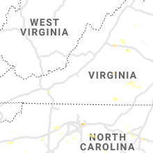
Virginia
| Local Time | Report Details |
|---|---|
| 4:51 PM EDT | Barn roof blown away near the intersection of route 11 and smithland rd in rockingham county VA, 62.7 miles ESE of Elkins, WV |
| 5:04 PM EDT | Multiple trees reported down in the area of indian trail road near keezletow in rockingham county VA, 66.3 miles ESE of Elkins, WV |
| 5:04 PM EDT | Multiple trees reported down in the mountain valley road area near keezletow in rockingham county VA, 66.7 miles ESE of Elkins, WV |
| 5:08 PM EDT | Large branches downed in rockingham county VA, 69.5 miles ESE of Elkins, WV |
| 5:10 PM EDT | Several limbs down along big river r in mecklenburg county VA, 61.7 miles N of Raleigh, NC |
| 5:20 PM EDT | Quarter sized hail reported near Afton, VA, 70.5 miles WNW of Richmond, VA |
| 5:38 PM EDT | Tree reported down on sperryville pike near griffinsburg roa in culpeper county VA, 74.3 miles NNW of Richmond, VA |
| 5:40 PM EDT | Large limbs and small trees down on power lines in powhatan. some small hail also reporte in powhatan county VA, 12.9 miles WNW of Richmond, VA |
| 5:55 PM EDT | Quarter sized hail reported near Heathsville, VA, 74.7 miles ENE of Richmond, VA, quarter size hail reported along bay quarter drive. |
| 5:55 PM EDT | Multiple downed trees across hydraulic rd in albemarle county VA, 60.7 miles NW of Richmond, VA |
| 5:58 PM EDT | Downed tree near greenbrier dr and rio rd in albemarle county VA, 59.4 miles NW of Richmond, VA |
| 5:59 PM EDT | Reports of 2 trees down along bay quarter dr. time estimated via rada in northumberland county VA, 74.2 miles ENE of Richmond, VA |
| 6:00 PM EDT | Trees reported down on commonwealth driv in albemarle county VA, 60.3 miles NW of Richmond, VA |
| 6:00 PM EDT | Reports of structural damage to houses and potential gas leak along bay quarter dr. time estimated from rada in northumberland county VA, 74.2 miles ENE of Richmond, VA |
| 6:00 PM EDT | Large tree reported down blocking parts of four seasons drive in the rio are in albemarle county VA, 60.7 miles NW of Richmond, VA |
| 6:05 PM EDT | Trees down on osborne turnpik in henrico county VA, 16.5 miles ESE of Richmond, VA |
| 6:06 PM EDT | Tree reported down on river oaks lane in the dunlora area of charlottesvill in albemarle county VA, 58.6 miles NW of Richmond, VA |
| 6:14 PM EDT | Tree reported down on the 13300 block of albano roa in orange county VA, 61.1 miles NW of Richmond, VA |
| 6:15 PM EDT | Several trees down across the extreme southeast part of the county impacting several roads... such as wolftrap road... coleman... and macdonald rd.... etc in halifax county VA, 66.9 miles N of Raleigh, NC |
| 6:22 PM EDT | Multiple trees reported down on ridge road near scuffletow in orange county VA, 61 miles NNW of Richmond, VA |
| 6:22 PM EDT | Multiple trees reported down on tatums school roa in madison county VA, 60.8 miles NNW of Richmond, VA |
| 6:23 PM EDT | Tree reported down on the 5300 block of ridge roa in orange county VA, 60.8 miles NW of Richmond, VA |
| 6:50 PM EDT | Tree down reported at route 645 and cedar creek roa in brunswick county VA, 41 miles SSW of Richmond, VA |
| 6:53 PM EDT | Numerous trees down across northern lunenburg county. many without power in victoria. time estimated via rada in lunenburg county VA, 43.7 miles SW of Richmond, VA |
| 6:56 PM EDT | Many trees reported down 4 n of kenbridge. time estimated via rada in lunenburg county VA, 41.5 miles SW of Richmond, VA |
| 7:20 PM EDT | Trees down across lake monticello. time estimated from rada in fluvanna county VA, 47.4 miles NW of Richmond, VA |
| 7:58 PM EDT | Tree down on harmony church road near loudoun orchard roa in loudoun county VA, 56.9 miles WSW of Baltimore, MD |
| 9:09 PM EDT | Tree reported down on braddick road near lacys tavern cour in loudoun county VA, 59.2 miles WSW of Baltimore, MD |
| 10:49 PM EDT | Tree down on sudley road at gum springs road in prince william county VA, 59 miles WSW of Baltimore, MD |
| 10:59 PM EDT | Tree down on us 50 at cedar lane in fairfax county VA, 45 miles SW of Baltimore, MD |
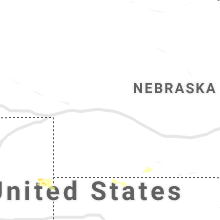
Kansas
| Local Time | Report Details |
|---|---|
| 4:27 PM CDT | Storm damage reported in morton county KS, 80 miles SW of Garden City, KS |
Tennessee
| Local Time | Report Details |
|---|---|
| 6:10 PM EDT | Several trees and power lines down in the kodak area. time estimated from rada in sevier county TN, 16.3 miles E of Knoxville, TN |
| 6:10 PM EDT | High winds downed trees on left and right shoulders and blew a tractor trailer backwards into other cars on interstate 40 between mile markers 400 and 405. time estimat in knox county TN, 13.2 miles ENE of Knoxville, TN |
Maryland
| Local Time | Report Details |
|---|---|
| 6:30 PM EDT | Storm damage reported in anz537 county MD, 75 miles NE of Richmond, VA |
Texas
| Local Time | Report Details |
|---|---|
| 5:35 PM CDT | Quarter sized hail reported near Perryton, TX, 87.3 miles NNE of Amarillo, TX, received report from perryton radio station kxdj of quarter size hail. |
| 5:35 PM CDT | Perryton radio station kxdj estimated 60-70 mph wind speeds on the southern part of the cit in ochiltree county TX, 78.1 miles W of Woodward, OK |
| 5:56 PM CDT | Schoolnet site reported a 58 mph gust at the wright elementary school in perryto in ochiltree county TX, 79.3 miles W of Woodward, OK |
| 6:02 PM CDT | Roof blown of outbuildin in ochiltree county TX, 82.1 miles W of Woodward, OK |
| 6:02 PM CDT | Quarter sized hail reported near Perryton, TX, 82.1 miles W of Woodward, OK, one inch hail reported. |
| 6:13 PM CDT | Ok mesonet truck equipped with an anomometer measured the 61 mph gust. picture of the event time stampe in ochiltree county TX, 78.2 miles W of Woodward, OK |
| 6:23 PM CDT | Quarter sized hail reported near Farnsworth, TX, 87.9 miles W of Woodward, OK, picture of hail mostly dime to nickel size with some quarter size mixed in. person noted this went on for 10 mins. |
| 6:33 PM CDT | Quarter sized hail reported near Farnsworth, TX, 87.9 miles W of Woodward, OK, person noted dime to quarter size hail fell for about 10 mins starting at 623 pm and ending at 633 pm |
| 7:20 PM CDT | Late report of schoolnet site gusting to 70 mph from a thunderstorm microburst in the paloduro area earlier this evenin in armstrong county TX, 45.2 miles SE of Amarillo, TX |
Illinois
| Local Time | Report Details |
|---|---|
| 6:20 PM CDT | Half Dollar sized hail reported near O Fallon, IL, 15.9 miles E of Saint Louis, MO |
Colorado
| Local Time | Report Details |
|---|---|
| 5:28 PM MDT | Golf Ball sized hail reported near Wray, CO, 30.8 miles ESE of Yuma, CO, hail up to golf ball size reported but hail was mainly pea size with a few large stones. |
| 5:55 PM MDT | Quarter sized hail reported near Vernon, CO, 24.9 miles ESE of Yuma, CO |
North Dakota
| Local Time | Report Details |
|---|---|
| 6:10 PM MDT | Golf Ball sized hail reported near Belfield, ND, 75.7 miles SSE of Williston, ND, just a few hailstones. very brief. |
| 6:35 PM MDT | Quarter sized hail reported near Belfield, ND, 78.9 miles SSE of Williston, ND, hailed for about 10 minutes. |
| 6:35 PM MDT | Half Dollar sized hail reported near Dickinson, ND, 86.4 miles SSE of Williston, ND, hail for about 10 minutes. 0.20 inch of rain. |
| 7:10 PM MDT | Half Dollar sized hail reported near Dickinson, ND, 88.1 miles SSE of Williston, ND |
| 11:15 PM CDT | Quarter sized hail reported near Leeds, ND, 26.9 miles WNW of Devils Lake, ND, media received photo of quarter sized diameter hail |
| 12:30 AM CDT | Quarter sized hail reported near Devils Lake, ND, 2 miles NNW of Devils Lake, ND |
| 2:54 AM CDT | Quarter sized hail reported near Hatton, ND, 61.7 miles NNW of Fargo, ND, public reported hail slightly larger than quarter sized just before 3 am. relayed via broadcast media. |
| 2:55 AM CDT | Ping Pong Ball sized hail reported near Hatton, ND, 61.7 miles NNW of Fargo, ND, facebook photo of large hail up to ping pong ball size in hatton |
Montana
| Local Time | Report Details |
|---|---|
| 8:15 PM MDT | Quarter sized hail reported near Lewistown, MT, 91.5 miles NNW of Billings, MT, started out as marble-sized... then increased to the size of quarters. hail is covering the ground. |
Minnesota
| Local Time | Report Details |
|---|---|
| 3:30 AM CDT | Quarter sized hail reported near Perley, MN, 21 miles N of Fargo, ND |
Iowa
| Local Time | Report Details |
|---|---|
| 3:50 AM CDT | Quarter sized hail reported near Superior, IA, 55.5 miles NNE of Storm Lake, IA, public report relayed to office by radio station. |
| 5:00 AM CDT | 12in tree down in waukee - via social media. time estimated via rada in dallas county IA, 12.7 miles W of Des Moines, IA |
| 5:20 AM CDT | Automated rwis site on interstate 8 in guthrie county IA, 53.5 miles W of Des Moines, IA |
| 5:25 AM CDT | Semi blown over at rest area on interstate 8 in adair county IA, 50.9 miles W of Des Moines, IA |
| 6:00 AM CDT | Several small and medium size tree branches dow in polk county IA, 7.3 miles WNW of Des Moines, IA |
| 6:02 AM CDT | Report from mping: 1-inch tree limbs broken; shingles blown of in warren county IA, 20.4 miles SSW of Des Moines, IA |
| 6:10 AM CDT | Road closed due to downed power lines. time estimated via rada in lucas county IA, 38.4 miles SE of Des Moines, IA |
| 6:15 AM CDT | Awos station kcnc chariton airpor in lucas county IA, 41.3 miles SSE of Des Moines, IA |
Connect with Interactive Hail Maps