

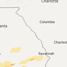
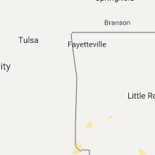
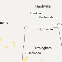
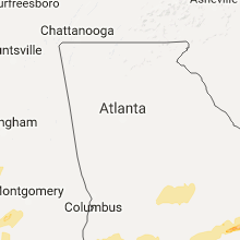
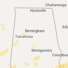
Hail Map for Saturday, January 21, 2017

Number of Impacted Households on 1/21/2017
0
Impacted by 1" or Larger Hail
0
Impacted by 1.75" or Larger Hail
0
Impacted by 2.5" or Larger Hail
Square Miles of Populated Area Impacted on 1/21/2017
0
Impacted by 1" or Larger Hail
0
Impacted by 1.75" or Larger Hail
0
Impacted by 2.5" or Larger Hail


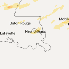


Cities Most Affected by Hail Storms of 1/21/2017
| Hail Size | Demographics of Zip Codes Affected | ||||||
|---|---|---|---|---|---|---|---|
| City | Count | Average | Largest | Pop Density | House Value | Income | Age |
| Vivian, LA | 2 | 2.00 | 2.00 | 64 | $44k | $26.7k | 38.1 |
| Oil City, LA | 1 | 2.00 | 2.00 | 55 | $45k | $22.1k | 39.3 |
| Mc David, FL | 1 | 2.00 | 2.00 | 21 | $71k | $35.5k | 43.9 |
| Mobile, AL | 1 | 2.00 | 2.00 | 1032 | $123k | $55.6k | 36.6 |
| Forest, MS | 1 | 1.75 | 1.75 | 59 | $50k | $25.8k | 33.9 |
| Magnolia, AR | 1 | 1.75 | 1.75 | 52 | $64k | $27.7k | 35.1 |
| Jonesville, LA | 1 | 1.75 | 1.75 | 15 | $53k | $24.6k | 40.4 |
| Springhill, LA | 1 | 1.75 | 1.75 | 174 | $50k | $27.7k | 41.5 |
| Braxton, MS | 1 | 1.75 | 1.75 | 23 | $67k | $34.3k | 39.6 |
| Chula, GA | 1 | 1.75 | 1.75 | 24 | $72k | $43.3k | 45.5 |
| Plain Dealing, LA | 1 | 1.75 | 1.75 | 14 | $50k | $25.6k | 43.9 |
| Natchez, MS | 1 | 1.75 | 1.75 | 69 | $61k | $25.2k | 41.3 |
Hail and Wind Damage Spotted on 1/21/2017
Filter by Report Type:Hail ReportsWind Reports
Alabama
| Local Time | Report Details |
|---|---|
| 6:04 AM CST | 18-wheeler blown over near benton on u.s. highway 80. in lowndes county AL, 35.2 miles NE of Camden, AL |
| 6:45 AM CST | Large pine tree uprooted... tree limbs snapped...and fence blown down near a public residenc in mobile county AL, 22.4 miles WNW of Mobile, AL |
| 6:45 AM CST | Tree down across car in sardis... al. time estimated by rada in dallas county AL, 27 miles NE of Camden, AL |
| 7:15 AM CST | Large tree on a home on darling lane in mobile county AL, 15.3 miles W of Mobile, AL |
| 7:20 AM CST | Tree snapped in safford... al. possible tornad in dallas county AL, 20.9 miles N of Camden, AL |
| 7:45 AM CST | Trees and powerlines down along hwy 14 in elmore. possible tornado. time estimated by rada in elmore county AL, 48.6 miles W of Auburn, AL |
| 7:57 AM CST | Damage to church of christ in west wetumpka. possible tornado. time estimated by rada in elmore county AL, 42.7 miles W of Auburn, AL |
| 7:57 AM CST | Powerlines down in redland. possible tornado. time estimated by rada in elmore county AL, 38.4 miles W of Auburn, AL |
| 8:00 AM CST | Several cars shifted and moved into each other due to thunderstorm win in mobile county AL, 4.7 miles WSW of Mobile, AL |
| 8:05 AM CST | Sheet metal and tree damage north of crawford. this is a correction from previous lsr. correct location is in lee county. possible tornado. time estimated by rada in lee county AL, 17.6 miles ESE of Auburn, AL |
| 8:10 AM CST | Barn destroyed along with shingle damage to a home near the intersection of highway 83 and county road 22. several trees downe in conecuh county AL, 36.8 miles SSE of Camden, AL |
| 8:18 AM CST | Several trees fallen on homes and trees down between hwy 31 and sowell r in escambia county AL, 62.3 miles SSE of Camden, AL |
| 8:18 AM CST | Sheet metal shed blown down... trees uprooted... and fence blown down in lyeffion... al on hwy 8 in conecuh county AL, 36.2 miles SSE of Camden, AL |
| 8:20 AM CST | Trees and powerlines down on washington st. in tuskegee. time estimated by rada in macon county AL, 20 miles SW of Auburn, AL |
| 8:22 AM CST | Several trees and power lines down in and around mckenzi in butler county AL, 46.3 miles SE of Camden, AL |
| 8:25 AM CST | Trees down along evergreen avenue in escambia county AL, 62.9 miles SSE of Camden, AL |
| 8:29 AM CST | Trees and powerlines down across willow springs rd. possible tornado. in elmore county AL, 41.1 miles WSW of Auburn, AL |
| 8:45 AM CST | Widespread reports of trees and powerlines down across lee county. in lee county AL, 0.5 miles WNW of Auburn, AL |
| 8:45 AM CST | Multiple trees down across tallapoosa county. roads were blocked... but have been cleared. in tallapoosa county AL, 22.3 miles NW of Auburn, AL |
| 8:48 AM CST | Numerous trees down on cr 43... just on the macon side of the lee/macon county line. possible tornad in macon county AL, 9 miles SSE of Auburn, AL |
| 9:05 AM CST | Sheet metal scattered in yard and tree damage north of crawford. possible tornado. time estimated by rada in russell county AL, 19.3 miles ESE of Auburn, AL |
| 9:10 AM CST | Trees down across george wallace drive in troy. possible tornado. time estimated by rada in pike county AL, 62 miles SSW of Auburn, AL |
| 9:18 AM CST | Damage to roof and athletic field at smiths station high school. possible tornado. time estimated by rada in lee county AL, 24.8 miles ESE of Auburn, AL |
| 9:23 AM CST | 4 trees down in the northern part of coffee count in coffee county AL, 77.5 miles SSW of Auburn, AL |
| 9:32 AM CST | Reports of trees down in louisville along county road 17. possible tornado. time estimated from rada in barbour county AL, 57.2 miles S of Auburn, AL |
| 9:42 AM CST | Large tree and tin roofing blocking county rd 278 at 4220. in chambers county AL, 35 miles NNE of Auburn, AL |
| 9:52 AM CST | Tree fell on car on matthews av in dale county AL, 80.2 miles S of Auburn, AL |
| 10:00 AM CST | Tree down on county rd 6 in dale county AL, 68.8 miles S of Auburn, AL |
| 10:05 AM CST | Widespread reports of trees and powerlines down across lee county. in lee county AL, 0.5 miles WNW of Auburn, AL |
| 10:40 AM CST | Downed power pole near the corner of hwy 55 and hwy 68 in loxley in baldwin county AL, 18.5 miles ESE of Mobile, AL |
| 10:44 AM CST | Trees down throughout randolph count in randolph county AL, 48.4 miles N of Auburn, AL |
| 6:55 PM CST | Hen Egg sized hail reported near Mobile, AL, 11.6 miles WSW of Mobile, AL, off duty nws employee reports 2 inch hail off dawes rd |
| 7:18 PM CST | Quarter sized hail reported near Elberta, AL, 33.1 miles SE of Mobile, AL, off duty nws employee reports one inch hail in elberta |
| 8:30 PM CST | Tree fell on commercial building in downtown brewton. time estimated via radar in escambia county AL, 61.5 miles SSE of Camden, AL |
| 10:14 PM CST | Quarter sized hail reported near Ozark, AL, 80.4 miles S of Auburn, AL, quarter sized hail reported in ozark |
| 10:24 PM CST | Quarter sized hail reported near Abbeville, AL, 75.7 miles SSE of Auburn, AL, quarter size hail reported on county road 57 |
| 10:25 PM CST | Quarter sized hail reported near Jemison, AL, 38.8 miles S of Birmingham, AL, hail to the size of quarters was reported in jemison. time estimated from radar. |
| 12:10 AM CST | Tree down along hwy 10 east in henry county AL, 74.9 miles SSE of Auburn, AL |
| 12:50 AM CST | Trees down on buddy vines camp r in jefferson county AL, 19.6 miles W of Birmingham, AL |
| 12:57 AM CST | Trees and power lines down on 8th place in pleasant grov in jefferson county AL, 11.1 miles W of Birmingham, AL |
| 12:57 AM CST | Numerous trees down in besseme in jefferson county AL, 11.9 miles SW of Birmingham, AL |
| 1:01 AM CST | Power lines down near 67th st and pineview r in jefferson county AL, 6.2 miles SW of Birmingham, AL |
| 1:07 AM CST | Tree down on queensview r in jefferson county AL, 6.9 miles S of Birmingham, AL |
| 1:07 AM CST | Trees down in homewoo in jefferson county AL, 3 miles SSE of Birmingham, AL |
| 1:08 AM CST | Trees down in vestavia hills... including at us highway 31 and kentucky av in jefferson county AL, 5 miles SSE of Birmingham, AL |
| 1:08 AM CST | Trees down near rocky ridg in jefferson county AL, 7.3 miles SSE of Birmingham, AL |
| 1:09 AM CST | Trees down near mcdonald st in tarran in jefferson county AL, 5.1 miles NNE of Birmingham, AL |
| 1:14 AM CST | 65 kts gust at kbhm airpor in jefferson county AL, 4.5 miles NE of Birmingham, AL |
| 1:18 AM CST | Tree down on i-65 at mm 28 in blount county AL, 27.1 miles N of Birmingham, AL |
| 1:29 AM CST | Tree down on home in locust for in blount county AL, 29 miles NNE of Birmingham, AL |
| 1:30 AM CST | Tree down on home on 3rd street in hayde in blount county AL, 25.7 miles N of Birmingham, AL |
| 1:38 AM CST | Trees down in oneont in blount county AL, 35.5 miles NNE of Birmingham, AL |
| 1:38 AM CST | Several second story windows blown out and damage to roofing and decking on front porch at the lester memorial methodist churc in blount county AL, 35.2 miles NNE of Birmingham, AL |
| 1:42 AM CST | Tree on home in susan moor in blount county AL, 44.7 miles NNE of Birmingham, AL |
| 2:05 AM CST | Tree down in ashford in houston county AL, 76.5 miles NW of Tallahassee, FL |
Louisiana
| Local Time | Report Details |
|---|---|
| 6:15 AM CST | Several homes with shingles blown off and fences down on furman driv in jefferson county LA, 10.5 miles W of New Orleans, LA |
| 4:55 PM CST | Hen Egg sized hail reported near Vivian, LA, 25.1 miles NW of Shreveport, LA, picture of 2 inch tweeted to the office. |
| 4:55 PM CST | Hen Egg sized hail reported near Oil City, LA, 20.8 miles NW of Shreveport, LA, 2 inch hail tweeted from the public. |
| 5:05 PM CST | Bossier sheriffs reporting damage in and around plain dealing... including trees down as well as damage to homes and vehicle in bossier county LA, 27.4 miles N of Shreveport, LA |
| 5:09 PM CST | Golf Ball sized hail reported near Plain Dealing, LA, 27.4 miles N of Shreveport, LA, bossier sheriffs are reporting golf ball size hail in plain dealing. |
| 5:10 PM CST | Quarter sized hail reported near Hosston, LA, 27.5 miles NNW of Shreveport, LA, quarter size hail in hosston at i49 and hwy 2. |
| 5:11 PM CST | Quarter sized hail reported near New Orleans, LA, 15.2 miles ENE of New Orleans, LA |
| 5:15 PM CST | Power lines down. mobile homes damaged... with people trapped east of plain dealin in bossier county LA, 27.7 miles N of Shreveport, LA |
| 5:15 PM CST | Heavy storm damage to several homes n the vicinity of mott rd...pleasant hill rd...and the shiloh area. multiple reports of down power lines and trees down. no reports in bossier county LA, 30.9 miles NNE of Shreveport, LA |
| 5:35 PM CST | Trees down across hwy 2. in bossier county LA, 34.1 miles NNE of Shreveport, LA |
| 5:38 PM CST | Multiple trees down on mott road... and structural damage to hom in bossier county LA, 27.4 miles N of Shreveport, LA |
| 5:50 PM CST | Golf Ball sized hail reported near Springhill, LA, 37.8 miles NNE of Shreveport, LA, golf ball size hail reported in springhill. |
| 5:50 PM CST | Hen Egg sized hail reported near Vivian, LA, 28.3 miles NNW of Shreveport, LA, . |
| 5:55 PM CST | Roof is off of a home along patrick roa in natchitoches county LA, 70.9 miles SE of Shreveport, LA |
| 5:55 PM CST | *** 1 inj *** two homes destroyed along patrick road and hwy 494. a man has a broken ar in natchitoches county LA, 70.5 miles SE of Shreveport, LA |
| 7:00 PM CST | Quarter sized hail reported near Jena, LA, 81.8 miles S of Bastrop, LA, quarter size hail in white hall along hwy 8. |
| 7:25 PM CST | Quarter sized hail reported near Dry Prong, LA, 90.1 miles SSW of Bastrop, LA, 1 inch hail in dry prong. |
| 7:28 PM CST | Half Dollar sized hail reported near Jonesville, LA, 82.6 miles S of Bastrop, LA |
| 7:30 PM CST | Quarter sized hail reported near Spearsville, LA, 41.9 miles WNW of Bastrop, LA, 1 inch hail in spearsville. |
| 7:46 PM CST | Golf Ball sized hail reported near Jonesville, LA, 80 miles S of Bastrop, LA, golf ball size hail reported in jonesville |
| 7:50 PM CST | Quarter sized hail reported near Pollock, LA, 82.3 miles SSW of Bastrop, LA, . |
| 7:50 PM CST | Trees snapped and uproote in union county LA, 30.9 miles WNW of Bastrop, LA |
| 8:30 PM CST | 2 businesses... several homes... and 2 vehicles damaged along highway 8... ending just before 310 in la salle county LA, 77.8 miles S of Bastrop, LA |
| 8:49 PM CST | Power lines down in mer roug in morehouse county LA, 7.3 miles E of Bastrop, LA |
Georgia
| Local Time | Report Details |
|---|---|
| 8:45 AM EST | Emergency manager reports limbs and trees down southwest of lagrang in troup county GA, 37.6 miles NE of Auburn, AL |
| 9:20 AM EST | Trees reported down in the northbound lane of i85 just south of exit 1 in troup county GA, 37.2 miles NE of Auburn, AL |
| 10:20 AM EST | Numerous trees down in laurel hills towards cgs airport in muscogee county GA, 30.4 miles ESE of Auburn, AL |
| 10:41 AM EST | 9 trees down in the town of cataula. one tree was hit by a car and another was on a hous in harris county GA, 35.8 miles E of Auburn, AL |
| 11:15 AM EST | Residents report heavy roof damage to 2 homes with trees also down. possible tornadic damag in taylor county GA, 71.3 miles S of Atlanta, GA |
| 11:17 AM EST | Multiple trees down near ll revell rd... cove rd... and shirey r in meriwether county GA, 56 miles ENE of Auburn, AL |
| 11:23 AM EST | In the western portion of the county there are many trees down near sunnsyside and pickard roads. some of the trees were larg in upson county GA, 57.8 miles S of Atlanta, GA |
| 12:05 PM EST | Roof damage near salters veterinary hospital via twitte in terrell county GA, 83.6 miles SE of Auburn, AL |
| 12:07 PM EST | Multpile trees reported down in this part of the maco in macon county GA, 87.5 miles NW of Douglas, GA |
| 12:15 PM EST | Fallen or leaning trees and limbs resulted in power outages in terrell county GA, 84.8 miles SE of Auburn, AL |
| 12:15 PM EST | Fallen or leaning trees and limbs resulted in power outages in terrell county GA, 87.7 miles N of Tallahassee, FL |
| 12:25 PM EST | Fallen trees or limbs resulted in power outages in lee county GA, 80.7 miles W of Douglas, GA |
| 12:25 PM EST | Fallen trees and limbs resulted in power outages in lee county GA, 82.7 miles WNW of Douglas, GA |
| 12:35 PM EST | Tree down at 3rd ave and dawson r in dougherty county GA, 78.7 miles W of Douglas, GA |
| 12:35 PM EST | Trees down blocking spring flats rd west of county line r in dougherty county GA, 68.5 miles W of Douglas, GA |
| 12:35 PM EST | Trees down blocking 400 block of mud creek r in dougherty county GA, 78 miles N of Tallahassee, FL |
| 12:40 PM EST | Stop sign blown over and tree fell on top of 2 cars on gleneagles dr in dougherty county GA, 76.6 miles N of Tallahassee, FL |
| 12:47 PM EST | Traffic lights and power lines down near venona. 46 mph wind in crisp county GA, 58 miles WNW of Douglas, GA |
| 12:48 PM EST | Numerous reports of trees down from marion northeast toward jeffersonville in twiggs county GA, 86.1 miles NNW of Douglas, GA |
| 12:50 PM EST | Numerous trees down just south and west of danville in twiggs county GA, 78 miles NNW of Douglas, GA |
| 12:50 PM EST | Several trees down near porters corner r in worth county GA, 65 miles W of Douglas, GA |
| 12:50 PM EST | Power lines down around baconton in mitchell county GA, 65.2 miles N of Tallahassee, FL |
| 12:54 PM EST | A large tree was blown down on rawls stree in pulaski county GA, 64.6 miles NW of Douglas, GA |
| 12:55 PM EST | A building on eastman highway received roof damag in pulaski county GA, 64 miles NNW of Douglas, GA |
| 1:00 PM EST | Several trees down near porters corner r in worth county GA, 65 miles W of Douglas, GA |
| 1:00 PM EST | Tree down on hwy 112 at the worth county lin in mitchell county GA, 67.4 miles NNE of Tallahassee, FL |
| 1:02 PM EST | Tree down on hwy 33 south of hwy 3 in worth county GA, 58.3 miles WNW of Douglas, GA |
| 1:02 PM EST | Tree down near gaines ave in dougherty county GA, 76.8 miles W of Douglas, GA |
| 1:08 PM EST | Trees were blown down onto highway 9 in wilkinson county GA, 85.5 miles SW of Augusta, GA |
| 1:08 PM EST | Multiple trees down and a small tramboline tangled in power lines in ashburn g in turner county GA, 49.2 miles WNW of Douglas, GA |
| 1:09 PM EST | 2 trees down in the rochelle community. time estimated from rada in wilcox county GA, 47.2 miles NW of Douglas, GA |
| 1:15 PM EST | Tree down on hwy 112 at the worth county lin in mitchell county GA, 67.4 miles NNE of Tallahassee, FL |
| 1:17 PM EST | One tree down along wilson road. time estimated from rada in wilcox county GA, 44.7 miles NW of Douglas, GA |
| 1:18 PM EST | One tree down along owensboro road... southwest of abbevill in wilcox county GA, 42.6 miles NW of Douglas, GA |
| 1:19 PM EST | Member of the public reported high winds to 60 mph. the winds were high enough to rock the mobile home they were in. there were no injurie in wilcox county GA, 43 miles NW of Douglas, GA |
| 1:19 PM EST | Numerous trees were blown down in southern wilkinson county...primarily in the toomsboro are in wilkinson county GA, 78.1 miles SW of Augusta, GA |
| 1:30 PM EST | Multiple trees down and an irrigation system toppled in ben hill county GA, 27.5 miles WNW of Douglas, GA |
| 1:40 PM EST | Reports of tress and power lines down along hwy 15 between mm 8-10 in johnson county GA, 69.8 miles SW of Augusta, GA |
| 1:43 PM EST | Possible tornadic damage. multiple trees fallen on homes and powerlines. one mobile home split in two by an uprooted tree. no injuries. just south of tennille at the in in washington county GA, 61.4 miles SW of Augusta, GA |
| 1:44 PM EST | Emergency manager reported at least 3 trees downed with no damages to structure in telfair county GA, 32.5 miles N of Douglas, GA |
| 1:49 PM EST | Numerous trees snapped and powerlines down. one tree fell and destroyed a home on the west side of sparta. possible tornado in hancock county GA, 60.3 miles WSW of Augusta, GA |
| 2:01 PM EST | Numerous trees and powerlines down between downtown swainsboro and industrial way... where a large tree fell on powerlines near a substation and knocked power ou in emanuel county GA, 64 miles SSW of Augusta, GA |
| 2:10 PM EST | Numerous trees down along canoochee bypass near lane rountree road. also reports of small metal building destroyed in this area. time estimated from radar. possible tor in emanuel county GA, 56.1 miles S of Augusta, GA |
| 2:13 PM EST | Public reported trees and power lines down across highway 17 nw of midville ga. wind damage extends north of highway 17 as well. irrigation system flipped and destroyed in burke county GA, 45.5 miles SSW of Augusta, GA |
| 2:15 PM EST | Clear path of trees fallen near ga hwy 78 and immediately east of ga 17 in jefferson county GA, 45.4 miles SSW of Augusta, GA |
| 2:15 PM EST | Tree down on st. paul church r in wheeler county GA, 36.6 miles NNE of Douglas, GA |
| 2:26 PM EST | Warning point reported a tree down on highway 121 north near the land fill. time estimated based on rada in candler county GA, 63 miles WNW of Savannah, GA |
| 2:29 PM EST | A tree was blown down on highway 1 near todds fish far in toombs county GA, 48.2 miles NE of Douglas, GA |
| 2:40 PM EST | Trees and powerlines reported down in northeast part of county near highway 144 and hendricks road. possible tornado touchdow in appling county GA, 46.4 miles ENE of Douglas, GA |
| 2:40 PM EST | Trees and powerlines reported down on morris landing road. possible tornado touchdow in appling county GA, 44 miles NE of Douglas, GA |
| 2:40 PM EST | Two trees uprooted and two sheds destroyed on scrub oak r in burke county GA, 28.9 miles S of Augusta, GA |
| 2:44 PM EST | Powerline reported down on n zetterower ave at northside drive east. time estimated based on rada in bulloch county GA, 48.1 miles WNW of Savannah, GA |
| 2:44 PM EST | Screven county warning point reports multiple trees down and damage to a shed in the 5300 block of buttermilk rd. possible tornado in screven county GA, 47.8 miles SSE of Augusta, GA |
| 2:48 PM EST | Trained spotter reported multiple trees... road signs... and powerlines down with damage to chicken coops including metal roofs removed with portions left in trees near in screven county GA, 47.1 miles SSE of Augusta, GA |
| 2:53 PM EST | Twtter report shows a car flipped on its side...a roof blown off a house...metal siding removed from a fire station...and various other damage near the intersection of in screven county GA, 52.6 miles SSE of Augusta, GA |
| 3:05 PM EST | Trees and powerlines down near jones street and tollison stree in appling county GA, 34.1 miles ENE of Douglas, GA |
| 3:30 PM EST | Clinch county emergency management reports that a shelter was blown down on 2 vehicles along leland smith roa in clinch county GA, 31.3 miles SSE of Douglas, GA |
| 3:34 PM EST | Warning point reported a portion of a commercial structure roof caved in near the intersection of weeping willow dr and veterans parkway. time estimated based on rada in liberty county GA, 35.6 miles WSW of Savannah, GA |
| 11:15 PM EST | Quarter sized hail reported near Albany, GA, 67.9 miles W of Douglas, GA, quarter size hail on south county line road |
| 11:31 PM EST | Ping Pong Ball sized hail reported near Poulan, GA, 55.5 miles W of Douglas, GA, report of ping pong sized hail in poulan |
| 11:55 PM EST | Golf Ball sized hail reported near Chula, GA, 37.1 miles W of Douglas, GA, golf ball sized hail reported in waterloo |
| 12:00 AM EST | Tree reported down in edison in calhoun county GA, 81.8 miles NNW of Tallahassee, FL |
| 12:20 AM EST | Tree reported down in leary in calhoun county GA, 72.9 miles N of Tallahassee, FL |
| 12:45 AM EST | Quarter sized hail reported near Albany, GA, 78.7 miles W of Douglas, GA, 1 inch hail reported in albany |
| 1:07 AM EST | Quarter sized hail reported near Ashburn, GA, 49.2 miles WNW of Douglas, GA |
| 1:40 AM EST | Tree reported down in arlington in calhoun county GA, 73.9 miles NNW of Tallahassee, FL |
| 2:17 AM EST | Reports of trees and power lines down in dougherty county GA, 78.7 miles W of Douglas, GA |
| 2:35 AM EST | Reports of trees down on houses in sylvester in worth county GA, 58.5 miles W of Douglas, GA |
| 4:28 AM EST | Trees down north henderson street in sylvester in worth county GA, 58.5 miles W of Douglas, GA |
| 4:35 AM EST | Powerlines downed off of hickory lane in nicholls georgi in coffee county GA, 7.4 miles SE of Douglas, GA |
| 5:55 AM EST | Preliminary report- appling county em reported several buildings with signifcant damage north of baxley including the appling county eoc... an ems facility... numerous in appling county GA, 37 miles NE of Douglas, GA |
Florida
| Local Time | Report Details |
|---|---|
| 10:31 AM CST | Tree down on powerline on spring lake r in walton county FL, 30.9 miles NE of Miramar Beach, FL |
| 7:49 PM CST | Half Dollar sized hail reported near Milton, FL, 51.4 miles WNW of Miramar Beach, FL, one to two inch hail reported near pace. time estimated via radar |
| 8:06 PM CST | Hen Egg sized hail reported near Mc David, FL, 35.2 miles ENE of Mobile, AL, reports of measured 2 inch hail near walnut hill. |
| 8:06 PM CST | Ping Pong Ball sized hail reported near Mc David, FL, 35.2 miles ENE of Mobile, AL, 1.5 to 2 inch hail reported in walnut hill.time estimated from radar |
| 6:13 AM EST | Multiple trees down on salem road in gadsden county FL, 16.7 miles NW of Tallahassee, FL |
| 6:15 AM EST | Power lines down on fairbanks ferry road in gadsden county FL, 16.1 miles NNW of Tallahassee, FL |
South Carolina
| Local Time | Report Details |
|---|---|
| 3:16 PM EST | Tree reported down on us-321 just south of scotia. time is estimated based on rada in hampton county SC, 40.9 miles NNW of Savannah, GA |
| 3:20 PM EST | Hampton county emergency management reported several trees down along mckenzie trail near furma in hampton county SC, 42.2 miles N of Savannah, GA |
| 3:27 PM EST | Hampton county emergency management reported several trees down on john penn road near cypress creek road. there was also damage to an old home in this area. possible t in hampton county SC, 43.4 miles N of Savannah, GA |
| 3:31 PM EST | Tree reported down on grays hwy. time estimated based on rada in jasper county SC, 39.5 miles N of Savannah, GA |
| 3:49 PM EST | Tree reported down at the intersection of enoch road and hudson mill road. time estimated based on rada in colleton county SC, 51.7 miles WSW of Charleston, SC |
| 3:52 PM EST | Numerous trees down in barnwell state park. 20-30 people are still trapped inside the park as of 6p in barnwell county SC, 40.4 miles ESE of Augusta, GA |
| 3:52 PM EST | *** 1 inj *** mobile home destroyed at pleasant home rd and hwy 3. a female inside the mobile home was trapped... rescued and transported to the hospital. extent of inj in barnwell county SC, 40 miles ESE of Augusta, GA |
| 4:00 PM EST | Public reported trees down and power poles snapped on gardenia rd near dally rd. photos relayed via social media. in bamberg county SC, 45.1 miles E of Augusta, GA |
| 4:02 PM EST | Numerous trees down on us hwy 78 west of denmark. road impassable and traffic being detoure in bamberg county SC, 46.4 miles ESE of Augusta, GA |
| 4:04 PM EST | Tree reported down at the intersection of paul street and wichman street. time estimated based on rada in colleton county SC, 42.8 miles WSW of Charleston, SC |
| 4:05 PM EST | Public report of trees down on us hwy 321 near orangeburg-bamberg co line. photos relayed via social medi in orangeburg county SC, 49.2 miles E of Augusta, GA |
| 4:05 PM EST | Trees down on hwy 70 at orangeburg-bamberg co line. photo relayed via social medi in orangeburg county SC, 52.2 miles E of Augusta, GA |
| 4:10 PM EST | Trees down at hwy 70 and hwy 332. photos relayed via social medi in orangeburg county SC, 54.4 miles E of Augusta, GA |
| 4:20 PM EST | Trees down at the intersection of us highway 301 and binnicker bridge rd. in orangeburg county SC, 57 miles WNW of Charleston, SC |
Texas
| Local Time | Report Details |
|---|---|
| 4:22 PM CST | Sheriffs office reporting power lines and trees down at fm 2199 and fm 199 in harrison county TX, 28.8 miles W of Shreveport, LA |
| 5:48 PM CST | Quarter sized hail reported near New Boston, TX, 45.7 miles SW of Nashville, AR, quarter size hail in new boston. |
Arkansas
| Local Time | Report Details |
|---|---|
| 5:33 PM CST | Quarter sized hail reported near Glenwood, AR, 36.4 miles NE of Nashville, AR, estimated hail size of 1 inch reported by public near highway 70 northeast of glenwood. |
| 5:55 PM CST | Golf Ball sized hail reported near Magnolia, AR, 46.3 miles NNE of Shreveport, LA, golf ball size hail along hwy 160 east of taylor. |
| 7:25 PM CST | Quarter sized hail reported near El Dorado, AR, 52.5 miles NW of Bastrop, LA, dime to quarter size hail in el dorado. |
| 7:35 PM CST | A house in lawson lost the roof and the side of the home caved i in union county AR, 45.6 miles NW of Bastrop, LA |
| 8:10 PM CST | Trees were blown down in rural portions of the county...primarily west of warre in bradley county AR, 58 miles N of Bastrop, LA |
| 8:20 PM CST | Quarter sized hail reported near Huttig, AR, 23.7 miles NW of Bastrop, LA, quarter size hail in huttig. it fell for several minutes. |
| 8:25 PM CST | Quarter sized hail reported near Pearcy, AR, 49.5 miles NE of Nashville, AR |
| 8:35 PM CST | Trees down along highways 133 and 18 in ashley county AR, 36 miles N of Bastrop, LA |
| 8:40 PM CST | A few trees were blown down on old warren roa in drew county AR, 56.2 miles N of Bastrop, LA |
| 8:45 PM CST | A few trees were blown down on old highway 1 in drew county AR, 60.4 miles N of Bastrop, LA |
| 8:47 PM CST | Trees were blown down along highway 42 in ashley county AR, 31.8 miles NNE of Bastrop, LA |
| 8:55 PM CST | A few trees were blown down on florence roa in drew county AR, 62.3 miles N of Bastrop, LA |
| 9:04 PM CST | Social media report of multiple powerlines blown down along highway 29 in lincoln county AR, 72.3 miles NNE of Bastrop, LA |
| 9:14 PM CST | Several trees down across town... one across the railroad track and some power lines dow in ashley county AR, 43.3 miles NNE of Bastrop, LA |
Mississippi
| Local Time | Report Details |
|---|---|
| 6:40 PM CST | Quarter sized hail reported near Moss Point, MS, 33.5 miles WSW of Mobile, AL |
| 7:54 PM CST | Quarter sized hail reported near Lumberton, MS, 77.6 miles WNW of Mobile, AL, quarter size hail on pistol ridge road...reported by hattiesburg eoc |
| 8:20 PM CST | Half Dollar sized hail reported near Vicksburg, MS, 40.4 miles W of Jackson, MS, near the vicksburg mall |
| 8:23 PM CST | Quarter sized hail reported near Brandon, MS, 12.2 miles ESE of Jackson, MS, hail up to the size of quarters was falling in the robinhood community. |
| 8:24 PM CST | Quarter sized hail reported near Vicksburg, MS, 38 miles W of Jackson, MS, hail to the size of quarters was falling near vicksburg. |
| 8:29 PM CST | Quarter sized hail reported near Beaumont, MS, 64.1 miles WNW of Mobile, AL, one inch hail reported near beaumont |
| 8:43 PM CST | Quarter sized hail reported near Flowood, MS, 8.7 miles ENE of Jackson, MS |
| 8:52 PM CST | Golf Ball sized hail reported near Natchez, MS, 73.9 miles WSW of Jackson, MS, golf ball size hail estimated in the church hill area |
| 8:53 PM CST | Quarter sized hail reported near Madison, MS, 16.7 miles N of Jackson, MS, hail to the size of quarters was falling south of lake caroline. |
| 8:55 PM CST | Quarter sized hail reported near Pelahatchie, MS, 25.8 miles E of Jackson, MS, nickel to quarter size hail between pelahatchie and the county line |
| 9:10 PM CST | Tree down across springfield road near the intersection of hwy 13s in scott county MS, 29.9 miles E of Jackson, MS |
| 9:15 PM CST | Quarter sized hail reported near Hattiesburg, MS, 76.9 miles WNW of Mobile, AL, quarter size hail in the mclaurin area |
| 9:15 PM CST | Quarter sized hail reported near Morton, MS, 30.7 miles E of Jackson, MS, quarter size hail in the morton area |
| 9:20 PM CST | Golf Ball sized hail reported near Forest, MS, 41.3 miles ENE of Jackson, MS, golf ball hail near hwy 35 and old jackson road in the hillsboro community |
| 9:30 PM CST | Power lines down along hwy 21 north in scott county MS, 42.1 miles E of Jackson, MS |
| 9:35 PM CST | Golf Ball sized hail reported near Braxton, MS, 22.8 miles SSE of Jackson, MS, golf ball hail in the braxton area. |
| 9:38 PM CST | Quarter sized hail reported near Wesson, MS, 43.2 miles SSW of Jackson, MS, quarter size hail in wesson and beauregard |
| 9:40 PM CST | Quarter sized hail reported near Beaumont, MS, 61.3 miles WNW of Mobile, AL, quarter size hail reported in beaumont with thunderstorm passage. time estimated via radar |
| 10:17 PM CST | Multiple trees down along hwy 18 between raleigh and white oak in smith county MS, 34.9 miles ESE of Jackson, MS |
| 10:38 PM CST | Trees down along sunshine road in lauderdale county MS, 63.6 miles S of Starkville, MS |
| 10:41 PM CST | *** 1 inj *** 1 injury sustained in a mobile home due to damaging winds in lauderdale county MS, 67.7 miles S of Starkville, MS |
| 10:44 PM CST | Trees down along rabbit road in lauderdale county MS, 65.9 miles SSE of Starkville, MS |
| 11:14 PM CST | Trees down along i-59 and county road 333 just west of enterprise in clarke county MS, 77.8 miles E of Jackson, MS |
| 11:27 PM CST | Trees and power lines down along greenhill loop road in lauderdale county MS, 74.1 miles WNW of Camden, AL |
| 11:29 PM CST | Trees down along koa road in lauderdale county MS, 76.2 miles SSE of Starkville, MS |
Connect with Interactive Hail Maps