

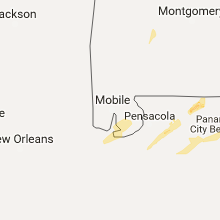
Hail Map for Sunday, January 22, 2017

Number of Impacted Households on 1/22/2017
0
Impacted by 1" or Larger Hail
0
Impacted by 1.75" or Larger Hail
0
Impacted by 2.5" or Larger Hail
Square Miles of Populated Area Impacted on 1/22/2017
0
Impacted by 1" or Larger Hail
0
Impacted by 1.75" or Larger Hail
0
Impacted by 2.5" or Larger Hail


Cities Most Affected by Hail Storms of 1/22/2017
| Hail Size | Demographics of Zip Codes Affected | ||||||
|---|---|---|---|---|---|---|---|
| City | Count | Average | Largest | Pop Density | House Value | Income | Age |
Hail and Wind Damage Spotted on 1/22/2017
Filter by Report Type:Hail ReportsWind Reports
Georgia
| Local Time | Report Details |
|---|---|
| 7:10 AM EST | Tree down at highway 133 and studstill r in brooks county GA, 55.5 miles SW of Douglas, GA |
| 7:20 AM EST | Report of building damaged at 3000 block of bemiss roa in lowndes county GA, 49.8 miles SSW of Douglas, GA |
| 7:25 AM EST | House damaged on swan driv in lowndes county GA, 50.5 miles SW of Douglas, GA |
| 7:44 AM EST | Em reports power lines down on hwy 187. time of event estimated with rada in clinch county GA, 35.2 miles S of Douglas, GA |
| 7:45 AM EST | Trees down near homerville georgi in clinch county GA, 32.6 miles S of Douglas, GA |
| 7:55 AM EST | Em reported power lines down along shiloh hwy in association with downed tree in clinch county GA, 36.7 miles S of Douglas, GA |
| 11:11 AM EST | Multpile trees reported down across arabi warwick road in southern crisp count in crisp county GA, 61.9 miles WNW of Douglas, GA |
| 2:24 PM EST | Widespread tree damage throughout county... heaviest near ft. gaines are in clay county GA, 76.4 miles SSE of Auburn, AL |
| 2:45 PM EST | Trees down throughout early county... but especially in the blakely and arlington area in early county GA, 73.6 miles NNW of Tallahassee, FL |
| 2:48 PM EST | Possible tornado damage. 14 mile path of damage from clay county to coleman to shellman. trees fell on multiple homes and a mobile home flipped over. no injuries or fat in randolph county GA, 75.4 miles SE of Auburn, AL |
| 3:55 PM EST | Numerous trees down along with structural damage to building near ga-hwy 300 and pateville road. possible tornado. time estimated from rada in crisp county GA, 63.4 miles WNW of Douglas, GA |
| 3:56 PM EST | Significant damage to mobile homes along south 7th street. additional damage extended northeast from this point on the south and east side of cordele. tornado possibl in crisp county GA, 62.4 miles WNW of Douglas, GA |
| 4:00 PM EST | Possible tornado- widespread damage between hwy 82 and hwy 32. trees on houses... in houses... and over roads. power outages in sylvester. no injuries or fatalitie in worth county GA, 61.5 miles W of Douglas, GA |
| 4:30 PM EST | Tree down on house and power lines down on 5 houses in pinecliff dr area of valdosta. trees down across valdosta and lake park are in lowndes county GA, 52.5 miles SSW of Douglas, GA |
| 4:31 PM EST | Power lines reported down on grassy pond rd in lowndes county GA, 62.7 miles SSW of Douglas, GA |
| 4:45 PM EST | Emergency manager reported multiple trees down southwest of douglas.the time given was based on rada in coffee county GA, 5.2 miles SW of Douglas, GA |
| 4:45 PM EST | Trees reported down in lake park in lowndes county GA, 60.4 miles SSW of Douglas, GA |
| 4:45 PM EST | Multiple trees down on highway 32 in coffee count in coffee county GA, 2.9 miles E of Douglas, GA |
| 4:45 PM EST | Emergency manager reported single wide mobile home damaged south of dougla in coffee county GA, 5.2 miles S of Douglas, GA |
| 5:00 PM EST | Single wide trailer home flipped over... 2 chicken houses destroyed... 1 chicken house damaged... trees down... and irrigation pivot turned upside down near hebron chur in coffee county GA, 10.7 miles WSW of Douglas, GA |
| 5:21 PM EST | Multiple trees down on highway 32 in coffee count in coffee county GA, 2.9 miles E of Douglas, GA |
| 6:40 PM EST | Trees down 2 miles east of i-95 near exit 22. possible tornad in camden county GA, 46.7 miles N of Jacksonville, FL |
| 7:05 PM EST | Quarter sized hail reported near Saint Simons Island, GA, 59.4 miles NNE of Jacksonville, FL, emergency manager reported quarter sized hail. |
Florida
| Local Time | Report Details |
|---|---|
| 9:00 AM EST | Several large trees down near killearn lakes and deerlake in leon county FL, 10.3 miles NNE of Tallahassee, FL |
| 9:00 AM EST | Trees down in leon county FL, 9 miles N of Tallahassee, FL |
| 9:25 AM CST | Quarter sized hail reported near Fort Walton Beach, FL, 15.8 miles WNW of Miramar Beach, FL, quarter sized hail. pictures from social media. |
| 10:10 AM CST | Quarter sized hail reported near Defuniak Springs, FL, 27.8 miles NNE of Miramar Beach, FL, photo received via email. |
| 10:30 AM CST | Large tree limb snapped in shalimar... fl in okaloosa county FL, 13.8 miles WNW of Miramar Beach, FL |
| 10:48 AM CST | Quarter sized hail reported near Hurlburt Field, FL, 19.9 miles W of Miramar Beach, FL, hail on hurlburt field. pictures via social media. |
| 12:00 PM CST | Multiple trees and power lines down in defuniak springs and freeport. time based on radar and operator log in walton county FL, 27.5 miles NNE of Miramar Beach, FL |
| 1:40 PM EST | Quarter sized hail reported near Jacksonville, FL, 9.9 miles E of Jacksonville, FL, local tv station received pictures of hail estimated to be around quarter sized along atlantic kernan. the time given was based on radar. |
| 1:00 PM CST | Multiple trees and power lines down in greater panama city are in bay county FL, 33.6 miles E of Miramar Beach, FL |
| 1:00 PM CST | Multiple trees down countywide. time estimated using radar and operator log in holmes county FL, 49.6 miles NE of Miramar Beach, FL |
| 1:00 PM CST | Multiple reports of trees down countywide. time estimated using radar and operator log in washington county FL, 42.3 miles ENE of Miramar Beach, FL |
| 1:04 PM CST | Drone runway...tdr in bay county FL, 49.3 miles ESE of Miramar Beach, FL |
| 1:30 PM CST | Multiple trees and power lines down countywide in calhoun county FL, 54.3 miles W of Tallahassee, FL |
| 1:34 PM CST | Storm damage reported in jackson county FL, 61.5 miles WNW of Tallahassee, FL |
| 1:34 PM CST | Storm damage reported in jackson county FL, 61.5 miles WNW of Tallahassee, FL |
| 2:39 PM EST | I-10 eastbound closed at mile marker 203 due to tree in road in gadsden county FL, 26.3 miles WNW of Tallahassee, FL |
| 2:42 PM EST | Trees and power lines down over us 90 in gadsden county FL, 26.3 miles WNW of Tallahassee, FL |
| 2:42 PM EST | Cr 157 and bell dr closed due to trees down in gadsden county FL, 16.7 miles NNW of Tallahassee, FL |
| 3:00 PM EST | Possible tornado near hwy65 and hwy 98 with trees and power lines down. tornado reported by public. times based on radar and operator log in franklin county FL, 58.1 miles SW of Tallahassee, FL |
| 3:00 PM EST | Reports of trees down in road in wakulla county FL, 31.5 miles SSW of Tallahassee, FL |
| 3:00 PM EST | On top of the world subdivision in ocala had a tree blown into a street lamp with the street lamp on top of a hous in marion county FL, 65.3 miles NW of Orlando, FL |
| 3:04 PM EST | Trees down in crawfordville in wakulla county FL, 18.7 miles SSW of Tallahassee, FL |
| 3:10 PM EST | Left hand southbound lane of us 98 closed due to trees down in wakulla county FL, 25 miles SSW of Tallahassee, FL |
| 3:15 PM EST | Several trees and power lines down. spotter notes all trees fell in same directio in wakulla county FL, 25.6 miles SSW of Tallahassee, FL |
| 3:28 PM EST | Trees down on capital circle ne in leon county FL, 3.7 miles NE of Tallahassee, FL |
| 3:30 PM EST | Spotter network reported trees down near old jacksonville road in ocal in marion county FL, 65 miles NW of Orlando, FL |
| 3:35 PM EST | Trees down near polos on park in leon county FL, 1.4 miles ENE of Tallahassee, FL |
| 3:35 PM EST | Trees down near keystone heights in clay county FL, 42.9 miles SSW of Jacksonville, FL |
| 3:45 PM EST | I-10 eastbound closed at mile marker 203 due to tree in road in gadsden county FL, 26.3 miles WNW of Tallahassee, FL |
| 3:54 PM EST | Trees and power lines down over us 90 in gadsden county FL, 26.3 miles WNW of Tallahassee, FL |
| 3:54 PM EST | I-10 at mile marker 238 closed due to trees down in madison county FL, 35.8 miles E of Tallahassee, FL |
| 3:59 PM EST | Left hand southbound lane of us 98 closed due to trees down in wakulla county FL, 25 miles SSW of Tallahassee, FL |
| 4:00 PM EST | Numerous trees down in jefferson county FL, 25.4 miles ENE of Tallahassee, FL |
| 5:30 PM EST | Emergency manager reported trees and powerlines down county wid in suwannee county FL, 77.8 miles E of Tallahassee, FL |
| 5:40 PM EST | Emergency management reported that several downed trees and powerlines along with three structures damage in pasco county FL, 51.8 miles N of Bradenton, FL |
| 5:55 PM EST | *** 1 inj *** emergency manager reported a large tree split a home in half in the lake city area near interstate 10 and u.s. highway 41. there was 1 injured. reports of in columbia county FL, 63.7 miles W of Jacksonville, FL |
| 5:55 PM EST | Large oak tree down along thompson ave in hudso in pasco county FL, 60.4 miles N of Bradenton, FL |
| 6:04 PM EST | Peak wind gust of 59 mph reported by asos at brooksville hernando county airport in hernando county FL, 66 miles W of Orlando, FL |
| 6:05 PM EST | Ham radio reported a 1.5 foot diameter tree down. time estimated by rada in hillsborough county FL, 25 miles NE of Bradenton, FL |
| 6:10 PM EST | 50 acre brush fire caused by downed powerlines. time estimated by rada in citrus county FL, 78.1 miles WNW of Orlando, FL |
| 6:30 PM EST | Large oak trees down on house on e hartshorn lane in holde in citrus county FL, 69.6 miles WNW of Orlando, FL |
| 6:48 PM EST | Quarter sized hail reported near Leesburg, FL, 35.8 miles WNW of Orlando, FL, picture via twitter of estimated quarter size hail in leesburg. time estimated. |
| 6:52 PM EST | Quarter sized hail reported near Tavares, FL, 28.5 miles NW of Orlando, FL, dime to quarter size hail reported in tavares. retweeted post from broadcast media. time estimated. |
| 7:11 PM EST | Asos measured a gust of 53 kt/61 mph from the ss in seminole county FL, 18.6 miles NNE of Orlando, FL |
| 7:12 PM EST | Picture on twitter of a tree down in the magnolia park area of sanford. time and location estimate in seminole county FL, 16.5 miles NNE of Orlando, FL |
| 7:15 PM EST | Twitter picture of tree down in maitland. location approximat in orange county FL, 6.3 miles N of Orlando, FL |
| 7:16 PM EST | Amateur radio operator reported that trees were down near us 19 and flora av in pasco county FL, 48.2 miles NNW of Bradenton, FL |
| 7:17 PM EST | Emergency management reported that 2 mobile homes sustained roof damage. time estimated by rada in polk county FL, 46.6 miles SW of Orlando, FL |
| 7:19 PM EST | Putnam county em reported a downed tree near state route 100 and sipprell roa in putnam county FL, 43.5 miles SSW of Jacksonville, FL |
| 7:30 PM EST | Trees in road near intersection of n hercules ave and ridgewood d in pinellas county FL, 36.5 miles NNW of Bradenton, FL |
| 7:35 PM EST | Quarter sized hail reported near Palm Coast, FL, 59.1 miles SSE of Jacksonville, FL, quarter size hail reported in c section of palm coast. |
| 7:35 PM EST | Quarter sized hail reported near Palm Coast, FL, 62.5 miles SSE of Jacksonville, FL, quarter size hail for 3 minutes reported in r section of palm coast. time of event estimated. |
| 7:47 PM EST | Measured wind gust of 63 mph/54 kt from the ssw at kev in volusia county FL, 42.9 miles NE of Orlando, FL |
| 7:50 PM EST | Several mobile homes with significant roof damage in heather hills estates and casa loma mobile home park in manatee county FL, 3.3 miles SSE of Bradenton, FL |
| 1:40 AM EST | A medium to large sized tree was uprooted off of donald ross road in palm beach gardens. time estimated by rada in palm beach county FL, 31.3 miles SSE of Port Saint Lucie, FL |
| 1:45 AM EST | In juno beach... mulitple posts on social media show down power lines... fallen trees and street signs down. time estimated by rada in palm beach county FL, 32.4 miles SE of Port Saint Lucie, FL |
| 2:33 AM EST | Wind gust of 61 mph was measured at 233 am in broward county FL, 26.7 miles NNE of Miami, FL |
| 3:18 AM EST | Wind gust of 60 mph measured just off of port everglades at 318 am in amz651 county FL, 26.5 miles NNE of Miami, FL |
| 3:46 AM EST | Tractor trailed overturned near nw 50th st and 74th ave in miami-dade reported by news media in miami-dade county FL, 8.1 miles NW of Miami, FL |
| 3:55 AM EST | Downed power lines... busted gates and mailboxes near nw 118th street and 5th ave in miami-dade county in miami-dade county FL, 10.5 miles N of Miami, FL |
| 5:01 AM EST | Mesonet station belleair /e6508 in pinellas county FL, 34.4 miles NNW of Bradenton, FL |
| 5:17 AM EST | Mesonet station 7 nw palmetto /xsky in gmz830 county FL, 8.4 miles NNW of Bradenton, FL |
Alabama
| Local Time | Report Details |
|---|---|
| 9:51 AM CST | Quarter sized hail reported near Foley, AL, 29.3 miles SE of Mobile, AL, hail seen in foley... al. several reports via social media. |
| 11:09 AM CST | Tree down on powerline on gainestown road near evergreen r in clarke county AL, 47.1 miles SW of Camden, AL |
| 12:12 PM CST | Widespread reports of trees down and power lines down across dale county between 11 am ct and 1 pm c in dale county AL, 80.4 miles S of Auburn, AL |
| 12:36 PM CST | Several trees down across state hwy 103 and county rd 4 in geneva county AL, 67 miles NE of Miramar Beach, FL |
| 12:38 PM CST | Numerous trees uprooted. in lowndes county AL, 49.6 miles ENE of Camden, AL |
| 12:45 PM CST | Tree uprooted in deatsvill in elmore county AL, 53.6 miles W of Auburn, AL |
| 12:59 PM CST | Roof damage and steeple blown off of churc in elmore county AL, 51.9 miles W of Auburn, AL |
| 1:00 PM CST | Possible tornado- multiple structures damaged or destroyed including a mobile home and a bar in henry county AL, 84.6 miles NW of Tallahassee, FL |
| 1:18 PM CST | Widespread trees down and power lines dow in houston county AL, 72.5 miles NW of Tallahassee, FL |
| 1:49 PM CST | Possible tornado. half the roof blown off a mobile hom in lee county AL, 4.9 miles SW of Auburn, AL |
| 1:55 PM CST | Columns blown out from under a porch. minor structural damage to a hom in tallapoosa county AL, 27.7 miles NW of Auburn, AL |
| 2:03 PM CST | Possible tornado. trees and powerlines down along pepperell parkwa in lee county AL, 6.6 miles ENE of Auburn, AL |
| 2:13 PM CST | Trees down on hwy 22 between wadley and roanoke blocking both lanes of road. trees down in wadley with power ou in randolph county AL, 36.1 miles N of Auburn, AL |
| 3:15 PM CST | 1 small tree and 1 large tree down near the intersection of denson avenue and beth street in the city of cullman in cullman county AL, 45.5 miles N of Birmingham, AL |
Mississippi
| Local Time | Report Details |
|---|---|
| 10:34 AM CST | Quarter sized hail reported near Lucedale, MS, 36.1 miles WNW of Mobile, AL, hail seen via a video sent by broadcast media in lucedale |
South Carolina
| Local Time | Report Details |
|---|---|
| 10:30 PM EST | Buoy 41004 reported 54 knot wind gus in amz370 county SC, 71.6 miles SE of Charleston, SC |
Connect with Interactive Hail Maps