

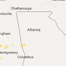
Hail Map for Friday, July 3, 2015

Number of Impacted Households on 7/3/2015
0
Impacted by 1" or Larger Hail
0
Impacted by 1.75" or Larger Hail
0
Impacted by 2.5" or Larger Hail
Square Miles of Populated Area Impacted on 7/3/2015
0
Impacted by 1" or Larger Hail
0
Impacted by 1.75" or Larger Hail
0
Impacted by 2.5" or Larger Hail


Cities Most Affected by Hail Storms of 7/3/2015
| Hail Size | Demographics of Zip Codes Affected | ||||||
|---|---|---|---|---|---|---|---|
| City | Count | Average | Largest | Pop Density | House Value | Income | Age |
| Buford, WY | 1 | 2.75 | 2.75 | 6 | $59k | $13.4k | 55.5 |
| Ingalls, KS | 1 | 2.00 | 2.00 | 1 | $71k | $39.0k | 35.9 |
| Copeland, KS | 1 | 1.75 | 1.75 | 2 | $66k | $39.8k | 31.9 |
| Cheyenne, WY | 1 | 1.75 | 1.75 | 26 | $135k | $54.6k | 42.7 |
| Louisville, MS | 1 | 1.75 | 1.75 | 41 | $57k | $28.7k | 38.9 |
| Thermopolis, WY | 1 | 1.75 | 1.75 | 3 | $81k | $29.9k | 49.0 |
Hail and Wind Damage Spotted on 7/3/2015
Filter by Report Type:Hail ReportsWind Reports
States Impacted
Georgia, South Carolina, Tennessee, Florida, Oklahoma, Alabama, Mississippi, Kansas, Texas, California, Wyoming, ColoradoGeorgia
| Local Time | Report Details |
|---|---|
| 8:30 AM EDT | At least 3 trees were blown down near downtown clarkesville along with the roof of a commercial business being ripped off. base velocity radar imagery of around 35 knot in habersham county GA, 54.5 miles WSW of Greenville, SC |
| 9:50 AM EDT | Several trees were reported down along lower fayetteville road near summergrove in coweta county GA, 32 miles SW of Atlanta, GA |
| 10:15 AM EDT | 911 center reports several trees down near highway 155 and jodeco road in henry county GA, 22.6 miles SE of Atlanta, GA |
| 11:05 AM EDT | Reports from 911 center of several trees down along highway 21 in jasper county GA, 45.1 miles SE of Atlanta, GA |
| 11:52 AM EDT | 911 center reports several trees and powerlines down between highway 22 and highway 4 in jones county GA, 74 miles SE of Atlanta, GA |
| 12:05 PM EDT | Tree down at wrightsboro road and baker place road. time estimated by rada in columbia county GA, 16.5 miles W of Augusta, GA |
| 1:00 PM EDT | Burke ema reported tree down on hills mill pond rd. time estimate in burke county GA, 32.9 miles SSW of Augusta, GA |
| 1:05 PM EDT | Burke ema reported tree down on herndon rd at mccollough church rd. time estimate in burke county GA, 33.3 miles S of Augusta, GA |
| 1:06 PM EDT | Burke ema reported tree down on hwy 56 at mile marker 15...which is 15 miles sw of waynesboro. time estimate in burke county GA, 40.7 miles SSW of Augusta, GA |
| 1:14 PM EDT | Large tree limbs were blown down on a private lot near grimm avenu in jenkins county GA, 45.5 miles S of Augusta, GA |
| 1:35 PM EDT | Power lines were blown down onto curtis and east ogeechee street in screven county GA, 54.1 miles SSE of Augusta, GA |
| 10:45 PM EDT | Several trees down in north columbus west of the airport. approx 1700 outages reported by georgia powe in muscogee county GA, 29.8 miles ESE of Auburn, AL |
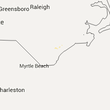
South Carolina
| Local Time | Report Details |
|---|---|
| 12:15 PM EDT | Tree down on hudson road in orangeburg county SC, 47.5 miles W of Charleston, SC |
| 12:27 PM EDT | Sc highway patrol reported trees down at the intersection of old jackson highway and old nail road. time estimated by rada in aiken county SC, 11.3 miles SE of Augusta, GA |
| 1:15 PM EDT | Tree down on hudson road in orangeburg county SC, 47.5 miles W of Charleston, SC |
| 1:37 PM EDT | South carolina highway patrol reported that a tree was blown down onto highway 601 north at the sandy run road intersection. time of event was estimated from radar data in hampton county SC, 57.8 miles N of Savannah, GA |
| 1:40 PM EDT | South carolina highway patrol reported that a tree was blown down onto murdaugh street at the walters place intersection. time of event was estimated from radar dat in hampton county SC, 54.5 miles N of Savannah, GA |
| 1:54 PM EDT | Sc highway patrol reports a tree down and in the roadway on sniders highway near deep creek church. time estimated from rada in colleton county SC, 55.4 miles WSW of Charleston, SC |
| 1:55 PM EDT | Tree down on wolfe creek roa in colleton county SC, 43.1 miles WSW of Charleston, SC |
| 2:00 PM EDT | Sc highway patrol reports a tree down and in the roadway in cummings along lownders lake road. time estimated from rada in hampton county SC, 48.5 miles N of Savannah, GA |
| 2:00 PM EDT | Sc highway patrol reports a tree down and in the roadway on pleasant grove road near the intersection with mcleod road. time estimated from rada in colleton county SC, 39.9 miles WSW of Charleston, SC |
| 2:09 PM EDT | Tree down at the intersection of cohen road and calf pen bay roa in jasper county SC, 35.9 miles N of Savannah, GA |
| 2:10 PM EDT | Sc highway patrol reports a tree down and in the roadway in the 2900 block of wesley chapel avenue. time estimated from rada in colleton county SC, 30.8 miles WSW of Charleston, SC |
| 2:25 PM EDT | Sc highway patrol reports a tree down and in the roadway near mile marker 25 on i-95 northbound. time estimated from rada in jasper county SC, 32.7 miles NNE of Savannah, GA |
| 2:33 PM EDT | Spotter estimates 60 mph winds and also has one large tree limb down. the limb is 4-5 inches in diameter and about 15 feet long. time estimated from rada in dorchester county SC, 17.3 miles SSW of Charleston, SC |
| 2:33 PM EDT | Sc highway patrol reports a tree down and in the roadway on tillman road near the wagon branch community center. time estimated from rada in jasper county SC, 26.3 miles N of Savannah, GA |
| 2:35 PM EDT | Sc highway patrol reports a tree down and in the roadway near the intersection of highway 17 and old jacksonboro roa in charleston county SC, 37.2 miles SW of Charleston, SC |
| 2:35 PM EDT | A trained spotter witnessed two trees blown down by a wind gust estimated to 60 mp in dorchester county SC, 20.8 miles SW of Charleston, SC |
| 2:35 PM EDT | Tree down on ashley river road between magnolia gardens and middleton plac in charleston county SC, 22 miles SSW of Charleston, SC |
| 2:35 PM EDT | An off-duty nws employee reported about 10 large trees snapped off and uprooted along fieldstone circle. shingles were also blown off some home in charleston county SC, 24.3 miles S of Charleston, SC |
| 2:38 PM EDT | Off duty nws employee reports two trees down along park forest parkway. numerous large limbs are also dow in dorchester county SC, 20.7 miles SSW of Charleston, SC |
| 2:40 PM EDT | A tree was blown down and was blocking nova court near the newport place intersection. time of event was estimated from radar dat in charleston county SC, 17.3 miles S of Charleston, SC |
| 2:40 PM EDT | Several trees on power lines at ashley river rd and tobias gadson blvd. time estimated by rada in charleston county SC, 26.7 miles S of Charleston, SC |
| 2:42 PM EDT | A few homes experienced shingle damage. a few doors also blew off storage sheds. damage occurred in covington hills just off dorchester road near the micheaux parkway i in charleston county SC, 22.7 miles S of Charleston, SC |
| 2:45 PM EDT | Large tree down on home causing roof damage in ponderosa neighborhood. time estimated based on rada in charleston county SC, 27.6 miles S of Charleston, SC |
| 2:45 PM EDT | Storm damage reported in charleston county SC, 20.5 miles S of Charleston, SC |
| 2:45 PM EDT | 50 foot tree across parts of south aviation ave near boein in charleston county SC, 22.5 miles S of Charleston, SC |
| 2:47 PM EDT | An off-duty nws employee reported a large metal sign bent by strong winds along interstate 26 west just south of the spruill avenue exi in charleston county SC, 25.4 miles S of Charleston, SC |
| 2:47 PM EDT | An off-duty nws employee reported a large metal sign bent by strong winds along interstate 26 west just south of the montague avenue exi in charleston county SC, 22.5 miles S of Charleston, SC |
| 2:48 PM EDT | Reported of a large tree down on a house. report relayed via social medi in berkeley county SC, 18.4 miles S of Charleston, SC |
| 2:48 PM EDT | The public relayed pictures of several large trees blown down on north shirley drive... water view circle... and waterview driv in charleston county SC, 23.3 miles S of Charleston, SC |
| 2:49 PM EDT | An off-duty nws employee reported a large metal sign bent by strong winds along interstate 26 west just south of the spruill avenue exi in charleston county SC, 25.4 miles S of Charleston, SC |
| 2:57 PM EDT | Trees were blown down at the intersection of johnnie dodds and houston northcutt blvd in charleston county SC, 28.2 miles SSE of Charleston, SC |
| 2:59 PM EDT | Spotter reports numerous large limbs down and estimated winds to be 65 mph near the intersection of rifle range road and coleman boulevar in charleston county SC, 29.4 miles SSE of Charleston, SC |
| 3:02 PM EDT | A tree was blown down across heathland way in the charleston national subdivision. a photo was received via social medi in charleston county SC, 26.5 miles SSE of Charleston, SC |
| 3:02 PM EDT | Tree down on secessionville roa in charleston county SC, 33 miles S of Charleston, SC |
| 3:03 PM EDT | South carolina highway patrol reported that a tree was blown down onto halfway creek road at the united drive intersection. time of event was estimated from radar dat in berkeley county SC, 20.4 miles SE of Charleston, SC |
| 3:10 PM EDT | Report of a tree down on an suv in the dunes west sub-division of mount pleasan in charleston county SC, 23.3 miles SSE of Charleston, SC |
| 3:10 PM EDT | Report of a tree down on an suv in the dunes west sub-division of mount pleasan in charleston county SC, 24.8 miles SSE of Charleston, SC |
| 3:26 PM EDT | Fire department reported tree down near 9905 us-17. time estimated based on rada in charleston county SC, 31.2 miles ESE of Charleston, SC |
| 1:36 AM EDT | Several trees and some signs down at hwy 17a and cypress gardens rd. time estimated by rada in berkeley county SC, 8.3 miles SSW of Charleston, SC |
Tennessee
| Local Time | Report Details |
|---|---|
| 11:17 AM CDT | Trees were blown down on sherwood road south of highway 4 in franklin county TN, 36.5 miles WNW of Chattanooga, TN |
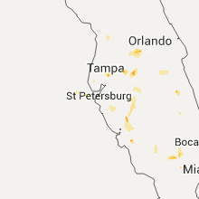
Florida
| Local Time | Report Details |
|---|---|
| 3:46 PM EDT | Tampa fire rescue reported walls were knocked down at a business on bonaker driv in hillsborough county FL, 36.6 miles NNE of Bradenton, FL |
| 3:55 PM EDT | Tampa fire rescue reported a roof off a business at 56th street and hanna. several power lines down and pea sized hai in hillsborough county FL, 36.6 miles NNE of Bradenton, FL |
| 5:45 PM EDT | American airlines reported some damage to aircraft. tstorm wind gust estimated at 55 mph. report received at cwsu miam in miami-dade county FL, 5.9 miles NNW of Miami, FL |
| 6:52 PM EDT | Quarter sized hail reported near Auburndale, FL, 41.3 miles SW of Orlando, FL, broadcast media relayed viewer pictures of hail around the size of quarter dollars in the auburndale area. time estimated from radar. |
| 7:25 PM EDT | Quarter sized hail reported near Winter Garden, FL, 20.5 miles W of Orlando, FL |
Oklahoma
| Local Time | Report Details |
|---|---|
| 3:33 PM CDT | Storm damage reported in ellis county OK, 23.2 miles WSW of Woodward, OK |
| 4:32 PM CDT | Large tree limbs downed in dewey county OK, 33.1 miles S of Woodward, OK |
| 4:48 PM CDT | Storm damage reported in dewey county OK, 41.9 miles S of Woodward, OK |
| 5:26 PM CDT | Half Dollar sized hail reported near Hardesty, OK, 91 miles S of Garden City, KS, a few stones were just larger than quarter size. |
| 6:00 PM CDT | Power lines down in the canadian area. time estimated by rada in pittsburg county OK, 61.1 miles NNE of Atoka, OK |
| 6:27 PM CDT | Tree down north of muldrow. time estimated by rada in sequoyah county OK, 10.8 miles WNW of Fort Smith, AR |
| 6:30 PM CDT | Tree limbs down north of muldrow. time estimated by rada in sequoyah county OK, 10.4 miles WNW of Fort Smith, AR |
| 6:38 PM CDT | Trees down in roland. time estimated by rada in sequoyah county OK, 5.6 miles WNW of Fort Smith, AR |
| 4:30 AM CDT | Storm damage reported in garvin county OK, 51.5 miles SE of Oklahoma City, OK |
Alabama
| Local Time | Report Details |
|---|---|
| 4:43 PM CDT | Ping Pong Ball sized hail reported near Centreville, AL, 42.2 miles SSW of Birmingham, AL, large hail reported in and around centreville with some damage. trees also reported down near brent. |
| 5:40 PM CDT | Quarter sized hail reported near Jemison, AL, 38.8 miles S of Birmingham, AL, numerous calls and reports from the jemison area of 1 inch hail...mixed with larger stones |
| 7:07 PM CDT | Several trees and powerlines down. also reports of pea to marble size hai in houston county AL, 72.4 miles NE of Miramar Beach, FL |
| 7:07 PM CDT | Large tree uprooted and fell into judge logue road blocking the roadway. tweeted photo by dothan fire dep in houston county AL, 77 miles NE of Miramar Beach, FL |
| 7:20 PM CDT | Tree blown down in the pinckard are in dale county AL, 80.4 miles NE of Miramar Beach, FL |
| 7:22 PM CDT | Quarter sized hail reported near Midland City, AL, 83.9 miles NE of Miramar Beach, FL, reported near wallace college. |
| 9:30 PM CDT | Trees down in numerous locations across chambers county including lafayette...lanett...and valle in chambers county AL, 21.4 miles NNE of Auburn, AL |
| 9:32 PM CDT | Several trees down. also a home weather station recorded a 57 mph wind gust in north phenix cit in russell county AL, 27.4 miles ESE of Auburn, AL |
| 12:05 AM CDT | Trees down in two separate locations near the eagle creek communit in tallapoosa county AL, 27.7 miles NW of Auburn, AL |
Mississippi
| Local Time | Report Details |
|---|---|
| 4:53 PM CDT | Quarter sized hail reported near Louisville, MS, 27.5 miles SSW of Starkville, MS, quarter size hail in louisville. report and picture relayed via social media. |
| 5:21 PM CDT | Quarter sized hail reported near Louisville, MS, 24.2 miles S of Starkville, MS, report of quarter size hail around 10 miles east of louisville. |
| 5:30 PM CDT | Multiple trees down in itta bena on thurman... haley... center... freedom and mitchell streets causing power outage in leflore county MS, 83.2 miles N of Jackson, MS |
| 5:45 PM CDT | Golf Ball sized hail reported near Louisville, MS, 32.4 miles SSW of Starkville, MS, golf ball size hail around 6 miles north of nanih waiya. report and picture relayed via social media. |
Kansas
| Local Time | Report Details |
|---|---|
| 5:28 PM CDT | Storm damage reported in finney county KS, 23.8 miles ENE of Garden City, KS |
| 4:33 PM MDT | Half Dollar sized hail reported near Kendall, KS, 37 miles W of Garden City, KS |
| 5:50 PM CDT | High-voltage transmission tower at this location was damaged in gray county KS, 21.5 miles ESE of Garden City, KS |
| 6:00 PM CDT | Large tree branches were down and automobile windows broken out at the charleston rest are in gray county KS, 20.7 miles ESE of Garden City, KS |
| 6:12 PM CDT | Power lines down at 8 and n road in gray county KS, 22.2 miles ESE of Garden City, KS |
| 6:14 PM CDT | Hen Egg sized hail reported near Ingalls, KS, 25 miles SE of Garden City, KS |
| 6:14 PM CDT | Storm damage reported in gray county KS, 25 miles SE of Garden City, KS |
| 6:15 PM CDT | Six center pivot spriklers were overturned in this vicinity from 6 road to 9 road along t road in gray county KS, 24.3 miles SE of Garden City, KS |
| 6:18 PM CDT | Power lines down and power poles snapped in gray county KS, 23.7 miles SE of Garden City, KS |
| 6:25 PM CDT | Part of the roof was blown from a residenc in gray county KS, 25 miles SE of Garden City, KS |
| 6:25 PM CDT | Numerous large limbs were blown from trees around a residenc in gray county KS, 23.4 miles SE of Garden City, KS |
| 6:25 PM CDT | Wind estimated at 80 to 100 mp in gray county KS, 26.9 miles SSE of Garden City, KS |
| 6:27 PM CDT | Center pivot overturned at y and 5 road in gray county KS, 27.2 miles SE of Garden City, KS |
| 6:32 PM CDT | Storm damage reported in gray county KS, 32.5 miles SSE of Garden City, KS |
| 6:33 PM CDT | Numerous large branches were blown down in copelan in gray county KS, 32.5 miles SSE of Garden City, KS |
| 6:36 PM CDT | Golf Ball sized hail reported near Copeland, KS, 33 miles SSE of Garden City, KS, the hailstones were reported to be soft. |
| 6:40 PM CDT | Powerlines were reported down at the intersection of road j and road 10 in gray county KS, 39.1 miles SSE of Garden City, KS |
Texas
| Local Time | Report Details |
|---|---|
| 6:30 PM CDT | Power lines downe in wilbarger county TX, 48.9 miles WNW of Wichita Falls, TX |
| 6:30 PM CDT | Quarter sized hail reported near Vernon, TX, 48.9 miles WNW of Wichita Falls, TX, damaging winds accompanied the hail. |
| 6:44 PM CDT | Irrigation pivot blown over in wilbarger county TX, 51.3 miles ESE of Childress, TX |
| 7:36 PM CDT | Storm damage reported in hutchinson county TX, 41.9 miles NE of Amarillo, TX |
| 7:36 PM CDT | Several trees uprooted and multiple power poles downed throughout tow in hutchinson county TX, 39.7 miles NE of Amarillo, TX |
| 8:53 PM CDT | Storm damage reported in potter county TX, 8.8 miles NNE of Amarillo, TX |
| 9:08 PM CDT | 61 mph gust reported at wonderland schoolnet mesonet in potter county TX, 1.8 miles NNE of Amarillo, TX |
| 9:09 PM CDT | At 34th avenue and bell street in randall county TX, 6.8 miles SW of Amarillo, TX |
| 9:10 PM CDT | Power pole down south 4th and birmingham - time estimated by radar in potter county TX, 0.9 miles ESE of Amarillo, TX |
California
| Local Time | Report Details |
|---|---|
| 4:35 PM PDT | Tree down/power lines down near intersection of almanor drive west and pole line roa in plumas county CA, 69.8 miles ESE of Redding, CA |
Wyoming
| Local Time | Report Details |
|---|---|
| 5:36 PM MDT | Baseball sized hail reported near Buford, WY, 19.6 miles SE of Laramie, WY, windshield of automobile severely damaged. |
| 5:39 PM MDT | Quarter sized hail reported near Meeteetse, WY, 91.1 miles N of Riverton, WY |
| 5:52 PM MDT | Quarter sized hail reported near Cheyenne, WY, 25.5 miles E of Laramie, WY, hail covering the ground. |
| 6:04 PM MDT | Quarter sized hail reported near Cheyenne, WY, 27.2 miles ESE of Laramie, WY |
| 6:08 PM MDT | Golf Ball sized hail reported near Cheyenne, WY, 27.2 miles ESE of Laramie, WY |
| 6:12 PM MDT | Quarter sized hail reported near Thermopolis, WY, 69.3 miles N of Riverton, WY, a trained spotter reported quarter size hail near the goosebury rest stop. |
| 6:12 PM MDT | Golf Ball sized hail reported near Thermopolis, WY, 69.3 miles N of Riverton, WY, a trained potter reported golf ball size hail. |
Colorado
| Local Time | Report Details |
|---|---|
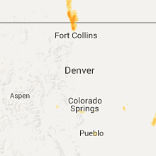
| 6:26 PM MDT | Ping Pong Ball sized hail reported near Livermore, CO, 29 miles SE of Laramie, WY |
| 6:39 PM MDT | Quarter sized hail reported near Colorado Springs, CO, 47.7 miles NNW of Pueblo, CO |
Connect with Interactive Hail Maps