

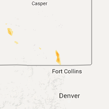
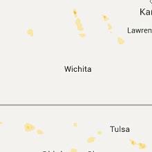
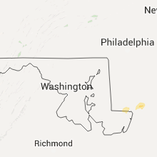
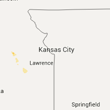
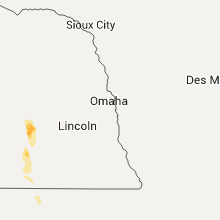
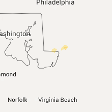
Hail Map for Thursday, July 2, 2015

Number of Impacted Households on 7/2/2015
0
Impacted by 1" or Larger Hail
0
Impacted by 1.75" or Larger Hail
0
Impacted by 2.5" or Larger Hail
Square Miles of Populated Area Impacted on 7/2/2015
0
Impacted by 1" or Larger Hail
0
Impacted by 1.75" or Larger Hail
0
Impacted by 2.5" or Larger Hail


Cities Most Affected by Hail Storms of 7/2/2015
| Hail Size | Demographics of Zip Codes Affected | ||||||
|---|---|---|---|---|---|---|---|
| City | Count | Average | Largest | Pop Density | House Value | Income | Age |
Hail and Wind Damage Spotted on 7/2/2015
Filter by Report Type:Hail ReportsWind Reports
States Impacted
South Dakota, Maryland, Alabama, Florida, Georgia, South Carolina, Texas, Colorado, Kentucky, Kansas, Arkansas, Oklahoma, Wyoming, Missouri, Tennessee, North CarolinaSouth Dakota
| Local Time | Report Details |
|---|---|
| 7:00 AM CDT | Several large trees down in shelterbelt and damage to a calf shelter. winds estimated over 70 mp in lyman county SD, 74.5 miles NE of Valentine, NE |
Maryland
| Local Time | Report Details |
|---|---|
| 11:05 AM EDT | After collaboration with county emergency management...wet microburst was determined to have downed several trees from marble court to kaywood drive... including the ti in wicomico county MD, 25.9 miles W of Ocean City, MD |
| 11:10 AM EDT | Downed tree just east of intersection of us-13 and north schumaker dr in wicomico county MD, 25.9 miles W of Ocean City, MD |
Alabama
| Local Time | Report Details |
|---|---|
| 11:44 AM CDT | Large tree uprooted near widows creek. report relayed via social medi in jackson county AL, 28.2 miles WSW of Chattanooga, TN |
| 11:47 AM CDT | A tree was blown down at the intersection of 2nd street and tennessee avenu in jackson county AL, 31.9 miles WSW of Chattanooga, TN |
| 11:49 AM CDT | Red light damaged by winds at the intersection of highway 72 east and cr 8 in jackson county AL, 31.9 miles WSW of Chattanooga, TN |
| 11:49 AM CDT | Several trees were reported down along cr 96. time estimated from rada in jackson county AL, 30.1 miles WSW of Chattanooga, TN |
| 11:49 AM CDT | Several trees were reported down along cr 277. time estimated from rada in jackson county AL, 29.1 miles WSW of Chattanooga, TN |
| 11:49 AM CDT | A tree was reported down over cr 27 in jackson county AL, 29.6 miles WSW of Chattanooga, TN |
| 11:51 AM CDT | A large tree branch 18 inches in diameter was reported blown off of a tre in jackson county AL, 29.1 miles WSW of Chattanooga, TN |
| 12:00 PM CDT | Tree down on cr-1 in dale county AL, 71.8 miles S of Auburn, AL |
| 12:07 PM CDT | Several trees down between samson and coffee springs. pea size hail also reporte in geneva county AL, 56.7 miles NNE of Miramar Beach, FL |
| 12:25 PM CDT | Tree down on church stree in dale county AL, 80.4 miles NE of Miramar Beach, FL |
| 12:57 PM CDT | A couple trees reported down in ashfor in houston county AL, 76.5 miles NW of Tallahassee, FL |
| 12:57 PM CDT | A couple trees down in cottonwoo in houston county AL, 73.8 miles NW of Tallahassee, FL |
| 12:57 PM CDT | Quarter sized hail reported near Hollywood, AL, 43.7 miles WSW of Chattanooga, TN, quarter sized hail reported in hollywood. relayed via social media. |
Florida
| Local Time | Report Details |
|---|---|
| 12:49 PM EDT | Tree down on house near nw 3 ave and nw 17 s in alachua county FL, 62.3 miles SW of Jacksonville, FL |
| 12:55 PM EDT | Power lines down at 108 ne 9th st in alachua county FL, 61.9 miles SW of Jacksonville, FL |
| 12:56 PM EDT | Tree down near sr-12 and lake mystic roa in liberty county FL, 41.3 miles W of Tallahassee, FL |
| 1:45 PM EDT | Broadcast media relayed social media reports of downed trees and tree limbs in wesley chapel. time estimated from rada in pasco county FL, 53.5 miles NNE of Bradenton, FL |
| 2:14 PM EDT | Twitter post of large tree down on cochran drive in leon county FL, 2.1 miles SSE of Tallahassee, FL |
| 2:42 PM EDT | Tree down on woods creek roa in taylor county FL, 42.9 miles ESE of Tallahassee, FL |
| 3:54 PM EDT | Storm damage reported in orange county FL, 8.9 miles SSE of Orlando, FL |
| 5:15 PM EDT | Quarter sized hail reported near Bonita Springs, FL, 13.2 miles N of Naples, FL, nws miami-south florida relayed a quarter sized hail report from a collier county deputy near bonita beach blvd and us41/tamiami trail. |
Georgia
| Local Time | Report Details |
|---|---|
| 1:08 PM EDT | Multiple trees down in sand mountain...trenton and lookout mountain in dade county GA, 16.7 miles SW of Chattanooga, TN |
| 1:21 PM EDT | One tree down along childress hollow road in walker county GA, 11.5 miles S of Chattanooga, TN |
| 2:10 PM EDT | Tree limbs and power lines down and wooden sign broken in carnesville in franklin county GA, 47.9 miles SW of Greenville, SC |
| 2:25 PM EDT | A few trees down in the city of blakel in early county GA, 75.7 miles NNW of Tallahassee, FL |
| 2:25 PM EDT | Fort benning asos in chattahoochee county GA, 34.5 miles ESE of Auburn, AL |
| 2:48 PM EDT | Quarter sized hail reported near Calhoun, GA, 42.9 miles SSE of Chattanooga, TN |
| 2:50 PM EDT | Tree down on hwy 25 in decatur county GA, 41.3 miles NNW of Tallahassee, FL |
| 2:58 PM EDT | Tree dow in decatur county GA, 37 miles NNW of Tallahassee, FL |
| 3:15 PM EDT | Large tree down on back 9 road in mitchell county GA, 50.1 miles N of Tallahassee, FL |
| 3:19 PM EDT | 2 trees down along hwy 9 in grady county GA, 33.3 miles N of Tallahassee, FL |
| 3:20 PM EDT | Tree and power line down on harney street in camilla in mitchell county GA, 54.6 miles N of Tallahassee, FL |
| 3:24 PM EDT | Tree down on highway 3 heading towards meigs in mitchell county GA, 46.2 miles NNE of Tallahassee, FL |
| 3:24 PM EDT | Tree down along hwy 3 north of lee white r in thomas county GA, 41 miles NNE of Tallahassee, FL |
| 3:48 PM EDT | Powerlines down on big oad roa in lee county GA, 74.3 miles W of Douglas, GA |
| 4:00 PM EDT | Multiple trees and powerlines down across the count in colquitt county GA, 58.7 miles NNE of Tallahassee, FL |
| 4:08 PM EDT | Large tree down over coffee road...east of hwy 87. time estimated from rada in dodge county GA, 46.2 miles NNW of Douglas, GA |
| 4:08 PM EDT | Approx. half dozen trees down along hull road...near old hull road. traffic light also out. reported by ema. time estimated from rada in clarke county GA, 63.2 miles ENE of Atlanta, GA |
| 4:10 PM EDT | Around a dozen pecan trees down near the town of rochelle. time estimated from rada in wilcox county GA, 47.2 miles NW of Douglas, GA |
| 4:12 PM EDT | Several trees down across northern brooks county near highway 13 in brooks county GA, 54.8 miles SW of Douglas, GA |
| 4:13 PM EDT | Numerous trees down across the county including on some home in worth county GA, 58.5 miles W of Douglas, GA |
| 4:15 PM EDT | Columbia county dispatch reported trees down along halali farm road. time estimated from rada in columbia county GA, 12.4 miles WNW of Augusta, GA |
| 4:18 PM EDT | Wagt reported blanchard road near paxton way impassable due to trees and powerlines dow in columbia county GA, 11.7 miles WNW of Augusta, GA |
| 4:22 PM EDT | Numerous trees down countywid in cook county GA, 42.1 miles SW of Douglas, GA |
| 4:33 PM EDT | Reported several trees down along walton way. structure damaged along walton way near the 3400 bloc in richmond county GA, 5.5 miles W of Augusta, GA |
| 4:36 PM EDT | Multiple trees and powerlines down across the count in tift county GA, 39.2 miles W of Douglas, GA |
| 4:36 PM EDT | 911 center reports numerous trees and powerlines down across northern houston county in the warner robins are in houston county GA, 89.4 miles SSE of Atlanta, GA |
| 4:36 PM EDT | Trees down along clarks mill road in louisville. time estimated from rada in jefferson county GA, 41.5 miles SW of Augusta, GA |
| 4:37 PM EDT | Couple trees down across northern lowndes count in lowndes county GA, 45.2 miles SW of Douglas, GA |
| 4:44 PM EDT | Trees down on east railroad street in wadley. time estimated from rada in jefferson county GA, 49.3 miles SSW of Augusta, GA |
| 4:49 PM EDT | Numerous trees down across the count in lanier county GA, 34.6 miles SSW of Douglas, GA |
| 4:49 PM EDT | Tree down at lax hwy and lilac r in irwin county GA, 17.8 miles W of Douglas, GA |
| 4:49 PM EDT | Multiple trees and powerlines down in the northern part of the count in berrien county GA, 23.5 miles WSW of Douglas, GA |
| 4:55 PM EDT | Trees down along highway 441 north of pearson. time of event based on radar imager in atkinson county GA, 12.8 miles S of Douglas, GA |
| 4:59 PM EDT | Tree down on hwy 122 near the clinch/lanier borde in clinch county GA, 28.7 miles SSW of Douglas, GA |
| 5:14 PM EDT | A tree was blown down along west plant avenue in homervill in clinch county GA, 32.6 miles S of Douglas, GA |
| 5:18 PM EDT | A tree was blown down along higway 8 in clinch county GA, 31.8 miles SSE of Douglas, GA |
| 5:18 PM EDT | Tree down on spring stree in coffee county GA, 1.8 miles NNE of Douglas, GA |
| 5:24 PM EDT | Trees and powerlines reported down throughout the county including southeast sections along highway 1 in twiggs county GA, 78.3 miles NNW of Douglas, GA |
| 5:32 PM EDT | Numerous large tree limbs...10 inches or more in diameter...blow onto powerlines on harvey street in jenkins county GA, 46.2 miles S of Augusta, GA |
| 5:37 PM EDT | Burke county dispatch reported downed powerlines in the town of sardi in burke county GA, 36.6 miles SSE of Augusta, GA |
| 5:37 PM EDT | Spotter saw strong straight line winds estimated at 60 mp in camden county GA, 31.6 miles N of Jacksonville, FL |
| 5:40 PM EDT | Public reported tree down via social media. time estimated by rada in camden county GA, 35.4 miles N of Jacksonville, FL |
| 5:44 PM EDT | Tree down on kemp st in tattnall county GA, 59.3 miles NE of Douglas, GA |
| 5:46 PM EDT | Numerous trees and powerlines down in the city of alm in bacon county GA, 21.9 miles E of Douglas, GA |
| 5:50 PM EDT | Powerlines blown down along red oak roa in appling county GA, 32.8 miles ENE of Douglas, GA |
| 5:52 PM EDT | Thunderstorm winds blew down power line in screven county GA, 57.1 miles S of Augusta, GA |
| 5:55 PM EDT | Two trees were blown down along highway 129 near the hillview road intersection. time of event was estimated from radar dat in evans county GA, 55.8 miles WNW of Savannah, GA |
| 5:56 PM EDT | Powerlines down caused a small fire along hwy 32 near the pierce county borde in bacon county GA, 31.3 miles E of Douglas, GA |
| 5:56 PM EDT | Reports of trees and power lines down across southeast appling county near the intersection of georgia highway 15 as far as georgia 20 in appling county GA, 37 miles E of Douglas, GA |
| 5:57 PM EDT | Tree down on victory dr in screven county GA, 48.3 miles SSE of Augusta, GA |
| 5:57 PM EDT | Tree down on buttermilk rd just outside sylvania in screven county GA, 51.5 miles SSE of Augusta, GA |
| 6:00 PM EDT | Numerous trees down along statesboro highway near sylvania in screven county GA, 54.9 miles NW of Savannah, GA |
| 6:13 PM EDT | Tree down across cyril p burkhalter road in tattnall county GA, 53.2 miles W of Savannah, GA |
| 6:25 PM EDT | Numerous large pine trees and limbs down near the east georgia regional medical center in bulloch county GA, 46.1 miles WNW of Savannah, GA |
| 6:45 PM EDT | Numerous large tree limbs...as large as 6 to 8 inches...down around the town of ludowici in long county GA, 46.4 miles WSW of Savannah, GA |
| 6:47 PM EDT | Tree down near the intersection of hwy 119 and hwy 80 north of ellabel in bulloch county GA, 26.4 miles WNW of Savannah, GA |
| 7:00 PM EDT | Liberty county emergency manager reports many trees blown down in and around riceboro extending to the long county border. trees brought down many power lines resulting in liberty county GA, 30.8 miles SW of Savannah, GA |
| 7:45 PM EDT | Storm damage reported in chatham county GA, 15.5 miles ESE of Savannah, GA |
South Carolina
| Local Time | Report Details |
|---|---|
| 1:35 PM EDT | Trees down on battlecreek rd and damascus church rd in oconee county SC, 37.7 miles W of Greenville, SC |
| 2:00 PM EDT | Trees down on poplar springs rd near seneca post office in oconee county SC, 22.6 miles WSW of Greenville, SC |
| 2:40 PM EDT | Trees down at e calhoun st and old colony rd in anderson county SC, 21.5 miles S of Greenville, SC |
| 2:40 PM EDT | Tree down in piedmont near bonanza cir in greenville county SC, 11.5 miles SE of Greenville, SC |
| 2:45 PM EDT | Tree down on fairview rd at hwy 418 in simpsonville in greenville county SC, 22.7 miles ESE of Greenville, SC |
| 2:45 PM EDT | Tree down off hwy 25 in greenville county SC, 17.8 miles SE of Greenville, SC |
| 2:45 PM EDT | Tree and powerlines down off vinewood st in piedmont in greenville county SC, 11.5 miles SE of Greenville, SC |
| 3:15 PM EDT | Tree down near eastside baptist church. time estimated from radar in laurens county SC, 39.7 miles SE of Greenville, SC |
| 3:15 PM EDT | Power lines down off pond view dr in laurens county SC, 41.3 miles SE of Greenville, SC |
| 3:15 PM EDT | Power lines down off pond view dr. time estimated from radar in laurens county SC, 41.3 miles SE of Greenville, SC |
| 3:35 PM EDT | 30 ft tall oak tree down on presbyterian college campus in laurens county SC, 48 miles ESE of Greenville, SC |
| 3:40 PM EDT | Trees down on hwy 26 just south of clinton in laurens county SC, 50.6 miles ESE of Greenville, SC |
| 3:40 PM EDT | Tree down on hwy 56 s and milton rd in laurens county SC, 52.1 miles SE of Greenville, SC |
| 3:40 PM EDT | Tree down on hwy 56 s and hwy 560 in newberry county SC, 56.4 miles SE of Greenville, SC |
| 3:40 PM EDT | Highway patrol reported trees down along i-26 near mile marker 6 in newberry county SC, 58.4 miles ESE of Greenville, SC |
| 3:44 PM EDT | Highway patrol reported trees down along jalapa road between i-26 and highway 7 in newberry county SC, 60.8 miles ESE of Greenville, SC |
| 3:48 PM EDT | Highway patrol reported trees down near the intersection of highway 176 and route 12 in newberry county SC, 65 miles ESE of Greenville, SC |
| 4:00 PM EDT | Sc highway patrol reported trees down near the intersection of mt pleasant rd and ringer roa in newberry county SC, 67.7 miles SSW of Charlotte, NC |
| 4:04 PM EDT | Trees down along highway 121/72 in chester county SC, 51 miles SW of Charlotte, NC |
| 4:05 PM EDT | Sheriff dispatch reported trees down along garrett roa in edgefield county SC, 18.3 miles NNW of Augusta, GA |
| 4:20 PM EDT | Public reported large branches down near dutch fork high school via social medi in richland county SC, 64.2 miles NE of Augusta, GA |
| 4:20 PM EDT | Trees down near the town of kersha in lancaster county SC, 48.4 miles SSE of Charlotte, NC |
| 4:21 PM EDT | Sheriff dispatch reported trees down along 9th street in winnsboro mill in fairfield county SC, 61.2 miles SSW of Charlotte, NC |
| 4:25 PM EDT | Sc highway patrol reported trees down along old graniteville road and along i 20 near vaucluse. time estimated from rada in aiken county SC, 13.6 miles NE of Augusta, GA |
| 4:25 PM EDT | Sheriff dispatch reported trees down along old river roa in fairfield county SC, 57 miles S of Charlotte, NC |
| 4:28 PM EDT | Highway department reported trees down along whaley pond road near gooseberry cour in aiken county SC, 10 miles NE of Augusta, GA |
| 4:29 PM EDT | Sheriff dispatch reported trees down along white oak church roa in fairfield county SC, 56.4 miles S of Charlotte, NC |
| 4:45 PM EDT | Sc highway patrol reported trees down near the intersection of gardners terrace road and highway 32 in lexington county SC, 59 miles ENE of Augusta, GA |
| 4:47 PM EDT | Public reported through twitter that a tree fell on a house in the olympia neighborhood of columbi in richland county SC, 64.5 miles ENE of Augusta, GA |
| 4:52 PM EDT | Richland county mesonet reported a wind gust of 70 mph atop williams brice stadiu in richland county SC, 64.6 miles ENE of Augusta, GA |
| 4:55 PM EDT | Wagt reported a tree on a house along radiance drive in n. august in aiken county SC, 2.6 miles NE of Augusta, GA |
| 4:57 PM EDT | Sc highway patrol reported trees down in north augusta near the 5th street bridg in aiken county SC, 1.5 miles E of Augusta, GA |
| 5:17 PM EDT | Report of tree down on n main st near citi trends. time estimated by rada in darlington county SC, 76.4 miles N of Charleston, SC |
| 5:21 PM EDT | A tree was reported down in the 600 block of gilchrist road. the time was estimated based on radar dat in darlington county SC, 77.7 miles N of Charleston, SC |
| 5:21 PM EDT | Report of tree in roadway at intersection of pocket rd and oxford rd. time estimated by rada in darlington county SC, 77.5 miles N of Charleston, SC |
| 5:24 PM EDT | Trained spotter reported via social media trees down in the town of north and a measured wind gust of 52 mp in orangeburg county SC, 51.4 miles E of Augusta, GA |
| 5:24 PM EDT | Reported several trees down along gardenia roa in barnwell county SC, 40.3 miles E of Augusta, GA |
| 5:36 PM EDT | Report of tree down on e mciver rd near wellman rd. time estimated by rada in darlington county SC, 74.9 miles N of Charleston, SC |
| 5:38 PM EDT | A tree was reported down near the intersection of pocket road and charleston road. the time was estimated based on radar dat in darlington county SC, 76.6 miles N of Charleston, SC |
| 5:46 PM EDT | Report of tree in roadway near intersection of gilchrist rd and wire rd. time estimated by rada in darlington county SC, 77.7 miles N of Charleston, SC |
| 5:53 PM EDT | Sc highway patrol reported trees in the roadway on plowden mill road and radical road in sumter. time estimated from rada in sumter county SC, 51.1 miles NNW of Charleston, SC |
| 5:58 PM EDT | Report of powerlines down in roadway near at intersection of e old marion hwy and weatherford ln. time estimated by rada in florence county SC, 73.9 miles NNE of Charleston, SC |
| 6:01 PM EDT | Sc highway patrol reported trees down near re davis elementary school. time estimated from rada in sumter county SC, 50.5 miles NNW of Charleston, SC |
| 6:28 PM EDT | A tree was blown down onto power lines and a power pole was snapped at the intersection of reed street and south parler avenu in dorchester county SC, 32.9 miles W of Charleston, SC |
| 6:34 PM EDT | Sc state hwy patrol reports tree down on hope well rd near the intersection with grass hill rd in hampton county SC, 51.2 miles N of Savannah, GA |
| 6:37 PM EDT | Sc state hwy patrol reports a tree down on us rt 601 just north of crocketville in hampton county SC, 57.8 miles N of Savannah, GA |
| 6:50 PM EDT | Tree down at the intersection of seven acres rd and cypress grove ln in dorchester county SC, 32.1 miles W of Charleston, SC |
| 6:55 PM EDT | Sc state highway patrol reports a tree down in the 6700 block of rehoboth rd in colleton county SC, 30 miles WSW of Charleston, SC |
| 6:58 PM EDT | South carolina highway patrol reported a tree down on forks road near the sineath road intersection. time of event was estimated from radar dat in colleton county SC, 55.9 miles WSW of Charleston, SC |
| 7:00 PM EDT | Sc state hwy patrol reports tree down in 4800 block of peirce rd in colleton county SC, 26.9 miles WSW of Charleston, SC |
| 7:06 PM EDT | Sc state hwy patrol reports a tree down on interstate 95 nb at mile marker 46 in colleton county SC, 52.1 miles NNE of Savannah, GA |
| 7:17 PM EDT | Sc state highway patrol reports a tree down in the 9700 block of jacksonboro rd in colleton county SC, 33.7 miles WSW of Charleston, SC |
| 7:25 PM EDT | South carolina highway patrol reported a tree down on jacksonboro road near cottageville. time of event was estimated from radar dat in colleton county SC, 33.7 miles WSW of Charleston, SC |
| 7:31 PM EDT | Report of tree in roadway on park ave near turbeville hw in florence county SC, 49.4 miles N of Charleston, SC |
| 7:40 PM EDT | County warning point reports numerous trees down in and around beaufor in beaufort county SC, 34.5 miles NE of Savannah, GA |
| 7:46 PM EDT | County warning point reports several trees down on ladys islan in beaufort county SC, 36.7 miles NE of Savannah, GA |
| 7:54 PM EDT | County warning point reports several trees down on hilton head islan in beaufort county SC, 21.9 miles ENE of Savannah, GA |
| 7:54 PM EDT | County warning point reports several trees down on hilton head islan in beaufort county SC, 24.1 miles ENE of Savannah, GA |
| 7:57 PM EDT | Tree down on orangeburg rd at dorchester r in dorchester county SC, 19.4 miles SW of Charleston, SC |
| 8:05 PM EDT | South carolina highway patrol reported that a tree was blown down onto sea island parkway. time of event was estimated from radar dat in beaufort county SC, 41 miles ENE of Savannah, GA |
| 8:28 PM EDT | Large bradford pear tree broken in half by wind on rosemead rd in charleston county SC, 28.3 miles SSE of Charleston, SC |
| 8:28 PM EDT | Tree down on lucas st by shem creek in charleston county SC, 29.1 miles SSE of Charleston, SC |
Texas
| Local Time | Report Details |
|---|---|
| 2:35 PM CDT | Power lines and poles reported down along county road 133 off highway 4 in jim wells county TX, 44.6 miles W of Corpus Christi, TX |
| 10:05 PM CDT | Sherriff office reported portion of roof blown off home...powerlines down and two large trees uprooted in panhandle area. trees were blocking the road near 3rd and elsi in carson county TX, 27.5 miles ENE of Amarillo, TX |
Colorado
| Local Time | Report Details |
|---|---|
| 2:35 PM MDT | Ping Pong Ball sized hail reported near Howard, CO, 67.8 miles W of Pueblo, CO |
Kentucky
| Local Time | Report Details |
|---|---|
| 4:10 PM CDT | Trees reported dow in barren county KY, 71.8 miles S of Louisville, KY |
Kansas
| Local Time | Report Details |
|---|---|
| 5:00 PM CDT | Quarter sized hail reported near Meade, KS, 62.8 miles NW of Woodward, OK |
| 5:14 PM CDT | Quarter sized hail reported near Manhattan, KS, 9.4 miles SE of Manhattan, KS |
Arkansas
| Local Time | Report Details |
|---|---|
| 5:01 PM CDT | Tree down in benton county AR, 54.6 miles N of Fort Smith, AR |
| 7:30 PM CDT | Strong thunderstorm wind damaged homes...destroyed a barn...and blew down trees onto homes. time estimated based on rada in washington county AR, 42.7 miles N of Fort Smith, AR |
Oklahoma
| Local Time | Report Details |
|---|---|
| 5:05 PM CDT | 2-4 in. tree limbs down on hwy 10 in payne county OK, 51.4 miles NE of Oklahoma City, OK |
| 5:33 PM CDT | Tree limbs blown down and a dead tree blown over near the clear lake are in beaver county OK, 51.6 miles WNW of Woodward, OK |
| 5:55 PM CDT | Additional gust of 67 mph at 600 pm. via ok mesone in beaver county OK, 49.3 miles WNW of Woodward, OK |
| 6:00 PM CDT | South of midway church...trees of 8 to 12 inch diamter were downed and a power pole was broke in beaver county OK, 48.1 miles W of Woodward, OK |
| 6:00 PM CDT | Several high line power poles downed on north-south road 153 a few miles south of highway 41 in beaver county OK, 49.8 miles WNW of Woodward, OK |
| 6:00 PM CDT | Several high line power poles downed on north-south road 153 a few miles south of highway 41 in beaver county OK, 48 miles WNW of Woodward, OK |
| 6:24 PM CDT | Tree limbs blown down and a dead tree blown over near the clear lake are in beaver county OK, 51.6 miles WNW of Woodward, OK |
| 6:41 PM CDT | Several large tree limbs dow in tulsa county OK, 6.9 miles E of Tulsa, OK |
| 6:43 PM CDT | Numerous tree limbs down. 11th and garnett are in tulsa county OK, 7.5 miles E of Tulsa, OK |
Wyoming
| Local Time | Report Details |
|---|---|
| 4:24 PM MDT | Half Dollar sized hail reported near Laramie, WY, 2.2 miles ESE of Laramie, WY |
| 4:25 PM MDT | Ping Pong Ball sized hail reported near Laramie, WY, 3.4 miles SE of Laramie, WY |
Missouri
| Local Time | Report Details |
|---|---|
| 5:25 PM CDT | Several large tree limbs and branches blown dow in barry county MO, 56.9 miles SW of Springfield, MO |
| 5:29 PM CDT | Several large trees and power lines blown down. the city of washburn has no powe in barry county MO, 56.7 miles SW of Springfield, MO |
| 5:45 PM CDT | Reports of trees blown down between washburn and seligman along highway 3 in barry county MO, 58.3 miles SW of Springfield, MO |
| 6:01 PM CDT | Quarter sized hail reported near Seligman, MO, 59.6 miles SW of Springfield, MO, video on social media showing quarter size hail falling in seligman |
Tennessee
| Local Time | Report Details |
|---|---|
| 5:30 PM CDT | Shingles blown from a house and two trees blown down at 4600 block of brownleaf driv in davidson county TN, 9.6 miles NE of Nashville, TN |
| 7:25 PM CDT | Trees down. possible tornado damag in wilson county TN, 24.5 miles E of Nashville, TN |
| 7:28 PM CDT | Planks from fence at speedway gas station... on highway 231 just south of i-40... blown into parking lot and onto hartmann drive. tree limbs also blown down along hartm in wilson county TN, 25.7 miles E of Nashville, TN |
| 7:35 PM CDT | Trees down and tin rolled up on roof of portable medical unit at fairgrounds. possible tornado damag in wilson county TN, 26.9 miles E of Nashville, TN |
| 7:36 PM CDT | Trees and powerlines down near bluebird road and old bluebird road. tree on car. possible tornado damag in wilson county TN, 26.9 miles E of Nashville, TN |
| 7:37 PM CDT | Power lines down on peyton road just east of lebanon. small shed blown into roadway. possible tornado damag in wilson county TN, 27.4 miles E of Nashville, TN |
North Carolina
| Local Time | Report Details |
|---|---|
| 7:01 PM EDT | Power lines reported down in selma... time estimated by radar in johnston county NC, 26.1 miles SE of Raleigh, NC |
Connect with Interactive Hail Maps