

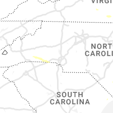
Hail Map for Monday, July 3, 2023

Number of Impacted Households on 7/3/2023
0
Impacted by 1" or Larger Hail
0
Impacted by 1.75" or Larger Hail
0
Impacted by 2.5" or Larger Hail
Square Miles of Populated Area Impacted on 7/3/2023
0
Impacted by 1" or Larger Hail
0
Impacted by 1.75" or Larger Hail
0
Impacted by 2.5" or Larger Hail


Cities Most Affected by Hail Storms of 7/3/2023
| Hail Size | Demographics of Zip Codes Affected | ||||||
|---|---|---|---|---|---|---|---|
| City | Count | Average | Largest | Pop Density | House Value | Income | Age |
| Rapid City, SD | 4 | 2.13 | 2.75 | 111 | $119k | $47.4k | 44.3 |
| Farmington, MN | 1 | 1.90 | 1.90 | 379 | $152k | $63.5k | 32.2 |
| Shelby, NC | 1 | 1.75 | 1.75 | 300 | $81k | $36.6k | 38.4 |
| Florence, SD | 1 | 1.75 | 1.75 | 5 | $62k | $40.2k | 39.3 |
| Custer, SD | 1 | 1.75 | 1.75 | 8 | $92k | $36.7k | 51.5 |
| Aurelia, IA | 1 | 1.75 | 1.75 | 5 | $62k | $37.7k | 46.4 |
| Nemo, SD | 1 | 1.75 | 1.75 | 4 | $122k | $37.7k | 33.3 |
| Piedmont, SD | 1 | 1.75 | 1.75 | 23 | $88k | $41.5k | 41.4 |
| Wright, WY | 1 | 1.75 | 1.75 | 0 | $86k | $53.4k | 32.7 |
Hail and Wind Damage Spotted on 7/3/2023
Filter by Report Type:Hail ReportsWind Reports
States Impacted
Oklahoma, Alabama, North Carolina, Virginia, New York, South Carolina, Texas, Florida, West Virginia, Wisconsin, Wyoming, South Dakota, Arkansas, Maryland, Georgia, Connecticut, Iowa, Utah, New Mexico, New Jersey, Minnesota, NebraskaOklahoma
| Local Time | Report Details |
|---|---|
| 1:10 PM CDT | Storm damage reported in garfield county OK, 55 miles N of Oklahoma City, OK |
| 1:36 PM CDT | Quarter sized hail reported near Ada, OK, 40.7 miles NW of Atoka, OK, report from mping: quarter (1.00 in.). |
| 1:45 PM CDT | Power poles snappe in pontotoc county OK, 41.1 miles NW of Atoka, OK |
| 5:35 PM CDT | Mesonet station burn burneyvill in love county OK, 70.8 miles E of Wichita Falls, TX |
| 6:00 PM CDT | Storm damage reported in jackson county OK, 51.6 miles ENE of Childress, TX |
| 6:05 PM CDT | Storm damage reported in jackson county OK, 51.6 miles ENE of Childress, TX |
| 6:15 PM CDT | Storm damage reported in jackson county OK, 51.6 miles ENE of Childress, TX |
| 6:55 PM CDT | Storm damage reported in cotton county OK, 34.8 miles NNE of Wichita Falls, TX |
Alabama
| Local Time | Report Details |
|---|---|
| 1:30 PM CDT | Powerlines and trees down extending between hwy 724 & 81 eastward through hwy 91 (time estimated by radar data in franklin county AL, 22.9 miles SSE of Florence, AL |
| 1:30 PM CDT | Several trees roughly 6-12 inches in diameter blown over or have limbs broken off. other trees were also blown over east of this location (time estimated by radar data) in morgan county AL, 37.4 miles ESE of Florence, AL |
| 2:17 PM CDT | Half Dollar sized hail reported near Union Grove, AL, 65.1 miles NNE of Birmingham, AL, report from mping: half dollar (1.25 in.). |
| 3:26 PM CDT | Trees down around sardis city... a in etowah county AL, 59.9 miles NE of Birmingham, AL |
| 3:53 PM CDT | Tree down onto a roadwa in cherokee county AL, 62.3 miles SSW of Chattanooga, TN |
North Carolina
| Local Time | Report Details |
|---|---|
| 2:33 PM EDT | Emergency manager reported straight-line wind damage resulting in numerous downed trees and damage to homes and roofs. location of damage was along wallace fork rd and in halifax county NC, 70.3 miles NE of Raleigh, NC |
| 2:34 PM EDT | Numerous reports of trees down across halifax county. most reports coming out of enfield and scotland neck are in halifax county NC, 67.2 miles ENE of Raleigh, NC |
| 2:40 PM EDT | Trees downed along indian woods river rd. numerous power outages reported in the are in bertie county NC, 77.7 miles SW of Virginia Beach, VA |
| 2:40 PM EDT | Numerous trees reported down across much of western portions of northampton count in northampton county NC, 77.4 miles S of Richmond, VA |
| 2:40 PM EDT | Damage to roof of a house along dickens wildwood road. time estimated by rada in halifax county NC, 71.7 miles NE of Raleigh, NC |
| 2:47 PM EDT | Multiple trees down along mary chapel road. time estimated by rada in halifax county NC, 71.9 miles ENE of Raleigh, NC |
| 2:54 PM EDT | Trees down on highway 258. time estimated by rada in halifax county NC, 75.8 miles ENE of Raleigh, NC |
| 3:00 PM EDT | Corrects previous tstm wnd dmg report from 2 ese quitsna. trees downed along indian woods river rd. numerous power outages reported in the are in bertie county NC, 77.7 miles SW of Virginia Beach, VA |
| 3:00 PM EDT | Trees downed along indian river road. numerous power outages reported in the are in bertie county NC, 78.3 miles SW of Virginia Beach, VA |
| 3:10 PM EDT | Multiple large trees down at the intersection of big level road and rock springs roa in polk county NC, 45.7 miles NE of Greenville, SC |
| 3:30 PM EDT | Numerous trees down across much of the county including around rutherfordton. several roads were blocked by falling tree in rutherford county NC, 51.4 miles NE of Greenville, SC |
| 3:35 PM EDT | Numerous power outages in the nixonton area along nixontown road due to storm damage. time is estimate in pasquotank county NC, 40 miles SSW of Virginia Beach, VA |
| 3:37 PM EDT | Report from mping: 3-inch tree limbs broken and/or power poles broken. time corrected based on rada in rutherford county NC, 47.7 miles NE of Greenville, SC |
| 3:45 PM EDT | Trees reported down on gibbs road. power outages reported due to stor in currituck county NC, 15 miles S of Virginia Beach, VA |
| 3:45 PM EDT | Corrects previous tstm wnd dmg report from nixonton. numerous power outages in the nixonton area along nixontown road due to storm damage. time is estimate in pasquotank county NC, 40 miles SSW of Virginia Beach, VA |
| 3:49 PM EDT | Numerous trees down along polk county line road. other trees down across the county als in rutherford county NC, 47.4 miles NE of Greenville, SC |
| 4:05 PM EDT | Numerous trees and limbs down in and around forest cit in rutherford county NC, 54.3 miles NE of Greenville, SC |
| 4:12 PM EDT | Half Dollar sized hail reported near Mooresboro, NC, 49.1 miles W of Charlotte, NC, twitter report of half dollar hail. |
| 4:20 PM EDT | Golf Ball sized hail reported near Shelby, NC, 47.1 miles W of Charlotte, NC, corrects previous hail report from boiling springs nc. golf ball size hail. |
| 4:23 PM EDT | Reports of trees and power lines dow in pitt county NC, 77.8 miles E of Raleigh, NC |
| 4:40 PM EDT | Several trees reported down across roads including south post road and s. lafayette st. in the vicinity of ear in cleveland county NC, 39.2 miles W of Charlotte, NC |
| 4:42 PM EDT | Photos of trees fallen on trailer. time estimated from rada in martin county NC, 89.2 miles SW of Virginia Beach, VA |
| 4:46 PM EDT | Numerous customers without power around... and to the south... of the williamston area. time estimated based on rada in martin county NC, 88.3 miles SW of Virginia Beach, VA |
| 4:55 PM EDT | 580 customers without power between chocowinity and washington due to tree limbs falling on power lines. time estimated via rada in beaufort county NC, 91.5 miles E of Raleigh, NC |
| 5:00 PM EDT | Fire department and police personnel reported pine trees fallen on trailers. time estimated from rada in beaufort county NC, 89.2 miles E of Raleigh, NC |
| 5:00 PM EDT | Public reported multiple tree limbs... tree tops... and trees down throughout neighborhoo in beaufort county NC, 91.2 miles ESE of Raleigh, NC |
| 5:04 PM EDT | Trees and limbs down on ground across roanoke christian camp damaging playground equipment. time of damage estimated by rada in beaufort county NC, 93.7 miles E of Raleigh, NC |
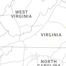
Virginia
| Local Time | Report Details |
|---|---|
| 2:47 PM EDT | Several very large branches blown down by thunderstorm winds on piney grove road. pea size hail was also observe in pittsylvania county VA, 42.8 miles ESE of Roanoke, VA |
| 3:08 PM EDT | Multiple trees down due to thunderstorm winds along patrick henry highwa in nelson county VA, 69.2 miles NE of Roanoke, VA |
| 3:15 PM EDT | Tree down at benefit road and blacksmith trail. time estimated by rada in city of chesapeake county VA, 15 miles SW of Virginia Beach, VA |
| 3:25 PM EDT | Tree down across route 651 in the vicinity of popes station roa in southampton county VA, 58.4 miles SSE of Richmond, VA |
| 3:28 PM EDT | Tree down across va-35 near farmers bridges rd. time estimated from rada in southampton county VA, 54.1 miles SSE of Richmond, VA |
| 3:50 PM EDT | Multiple trees down due to thunderstorm winds near the intersection of stony point road and turkey sag roa in albemarle county VA, 57.2 miles NW of Richmond, VA |
| 4:12 PM EDT | Tree downed on river road wes in goochland county VA, 18.4 miles NW of Richmond, VA |
| 4:40 PM EDT | Trees downed along sandy hook rd. va-522 near poorhouse roa in goochland county VA, 19.9 miles NW of Richmond, VA |
| 4:40 PM EDT | Report from mping: 1-inch tree limbs broken; shingles blown of in city of chesapeake county VA, 9.8 miles WNW of Virginia Beach, VA |
| 4:44 PM EDT | Tree downed on mountain road and rosmarin road. time estimated from rada in hanover county VA, 19.8 miles N of Richmond, VA |
| 4:46 PM EDT | Lafayette river tower reported a wind gust of 54k in city of norfolk county VA, 17.7 miles WNW of Virginia Beach, VA |
| 4:52 PM EDT | Third island tower reported a 58kt wind gust. fourth island reported a 44kt gus in anz632 county VA, 19.7 miles N of Virginia Beach, VA |
| 5:25 PM EDT | Quarter sized hail reported near Scottsburg, VA, 68.6 miles N of Raleigh, NC, a few hailstones as large as a quarter reported at a business on u.s. highway 360. |
| 5:27 PM EDT | One tree down due to thunderstorm winds along the 10500 block of belmont boulevar in fairfax county VA, 53.6 miles SW of Baltimore, MD |
| 5:27 PM EDT | One tree down due to thunderstorm winds along the 7600 block of wiley drive/ in fairfax county VA, 50.9 miles SW of Baltimore, MD |
| 6:02 PM EDT | Emergency manager reported structural/roof damage to 6 homes along little florida rd... including a buckled roof that allowed water to enter the hom in richmond county VA, 58.3 miles ENE of Richmond, VA |
| 7:17 PM EDT | Thunderstorm winds blew down a tree near the intersection of elon road and the blue ridge parkwa in amherst county VA, 38.5 miles ENE of Roanoke, VA |
| 7:47 PM EDT | Thunderstorm winds blew down one tree near the intersection of lowesville road and u.s. 6 in amherst county VA, 51.8 miles ENE of Roanoke, VA |
| 8:04 PM EDT | A few trees were downed by thunderstorm winds near the intersection of patrick henry highway and canodys store roa in amherst county VA, 57.9 miles ENE of Roanoke, VA |
| 8:24 PM EDT | Multiple trees blew down on us-29 and adjoining roads near lovingsto in nelson county VA, 67.6 miles ENE of Roanoke, VA |
| 8:30 PM EDT | Corrects previous tstm wnd dmg report from 2 sse oakville. thunderstorm winds blew down at least two trees near the intersection of dean johns place and oakville roa in appomattox county VA, 60.8 miles E of Roanoke, VA |
| 8:37 PM EDT | Thunderstorm winds blew a tree onto a powerline near the intersection of reedy spring road and richmond highwa in appomattox county VA, 56.5 miles E of Roanoke, VA |
| 8:38 PM EDT | Multiple trees down on old ridge road near woods mill. trees also down near ridgecrest baptist church on us-2 in nelson county VA, 68.4 miles WNW of Richmond, VA |
| 8:38 PM EDT | One tree down due to thunderstorm winds along the 3000 block of river roa in clarke county VA, 73.3 miles W of Baltimore, MD |
| 8:41 PM EDT | Thunderstorm winds blew down one tree near west james anderson highway near the appomattox county lin in buckingham county VA, 61.5 miles W of Richmond, VA |
| 9:00 PM EDT | Several trees down due to thunderstorm winds in the north garden are in albemarle county VA, 62 miles WNW of Richmond, VA |
| 9:06 PM EDT | Thunderstorms winds blew a tree onto a power line near elliott lan in appomattox county VA, 57.9 miles E of Roanoke, VA |
| 9:07 PM EDT | Thunderstorm winds blew a tree down on the road near police tower roa in appomattox county VA, 61 miles E of Roanoke, VA |
| 9:15 PM EDT | Thunderstorm winds blew a tree down on the road near the intersection of purdum mill road and country club lan in appomattox county VA, 60.2 miles E of Roanoke, VA |
| 9:21 PM EDT | Thunderstorm winds blew a tree down on rocks church roa in appomattox county VA, 60.4 miles WSW of Richmond, VA |
| 9:21 PM EDT | Several trees down due to thunderstorm winds along stony point roa in albemarle county VA, 57.3 miles NW of Richmond, VA |
| 9:24 PM EDT | Thunderstorm winds blew a tree onto the road near the intersection of old evergreen road and old bethany roa in appomattox county VA, 63.1 miles WSW of Richmond, VA |
| 9:24 PM EDT | Two trees blown down by thunderstorm winds near ca ira roa in buckingham county VA, 41.7 miles W of Richmond, VA |
| 9:34 PM EDT | Tree down on douglas church roa in prince edward county VA, 53 miles WSW of Richmond, VA |
| 9:36 PM EDT | Tree down along us-460 west of prospec in prince edward county VA, 54.2 miles WSW of Richmond, VA |
New York
| Local Time | Report Details |
|---|---|
| 3:00 PM EDT | Roof damage to vacant school on 3 maple av in orange county NY, 48.5 miles NNW of Brooklyn, NY |
| 3:00 PM EDT | Trees down on orange av in orange county NY, 51.6 miles NNW of Brooklyn, NY |
| 3:00 PM EDT | Trees down on south s in orange county NY, 51.1 miles NNW of Brooklyn, NY |
| 3:00 PM EDT | Tree on house on lakeview d in orange county NY, 50 miles NNW of Brooklyn, NY |
| 4:00 PM EDT | Poles & wires down on orange av in orange county NY, 51.6 miles NNW of Brooklyn, NY |
| 4:00 PM EDT | Trees down on south s in orange county NY, 51.1 miles NNW of Brooklyn, NY |
| 4:00 PM EDT | Tree on house on lakeview d in orange county NY, 50 miles NNW of Brooklyn, NY |
| 4:00 PM EDT | Multiple trees down along county highway 12. radar time estimat in otsego county NY, 62.2 miles WSW of Schenectady, NY |
| 4:05 PM EDT | Wires down via county dispatch. radar time estimat in sullivan county NY, 61.4 miles ENE of Scranton, PA |
| 4:30 PM EDT | *** 1 inj *** tree down on vehicle injuring drive in otsego county NY, 49.5 miles WSW of Schenectady, NY |
| 4:47 PM EDT | Multiple large trees down between 8 and 15 inches in diameter. some shingles blown off a roo in orange county NY, 45.2 miles NNW of Brooklyn, NY |
| 4:53 PM EDT | Tree down and road closure on us 9w southbound at academy ave. (cornwall) all lanes of 2 lanes blocked 2640 us hwy 9w and one n/b lane blocke in orange county NY, 52.3 miles N of Brooklyn, NY |
| 4:56 PM EDT | Ping Pong Ball sized hail reported near Cortlandt Manor, NY, 40.9 miles N of Brooklyn, NY, video confirming ping pong size hail. |
| 4:56 PM EDT | Quarter sized hail reported near Buchanan, NY, 39.9 miles N of Brooklyn, NY, quarter-sized hail observed 1 mile north of buchanan. |
| 5:10 PM EDT | Tree down and road closure on ny 35 both directions at greenwood st (somers) all lanes of 2 lanes blocke in westchester county NY, 42.7 miles NNE of Brooklyn, NY |
| 5:10 PM EDT | Multiple reports of trees down on roads... cars and houses with poles and wires down in multiple locations. power out for man in westchester county NY, 42.4 miles NNE of Brooklyn, NY |
| 5:10 PM EDT | Tree down on taconic state parkway southbound between croton reservoir bridge (yorktown) and exit 16 - franklin d. roosevelt drive state park road (yorktown) right lane in westchester county NY, 39.6 miles NNE of Brooklyn, NY |
| 5:10 PM EDT | Quarter sized hail reported near Yorktown Heights, NY, 41.2 miles NNE of Brooklyn, NY, photo verifies quarter-size hail. |
| 5:18 PM EDT | Tree down on taconic state parkway southbound south of exit 25 - peekskill hollow rd. - cr 21 (putnam valley) right lane of 2 lanes blocke in putnam county NY, 50.6 miles NNE of Brooklyn, NY |
| 5:22 PM EDT | Multiple reports of trees dow in westchester county NY, 46.7 miles NNE of Brooklyn, NY |
| 5:23 PM EDT | Trees down across multiple road in westchester county NY, 42.2 miles NNE of Brooklyn, NY |
| 5:23 PM EDT | Trees blocking two lane road... hwy 100... photo verifie in westchester county NY, 41.6 miles NNE of Brooklyn, NY |
| 6:07 PM EDT | Tree reported down at the mill creek apartments in east greenbus in rensselaer county NY, 18.6 miles SE of Schenectady, NY |
| 6:08 PM EDT | Metro north railroad train strikes tree near mt kisco. reported by metro north railroa in westchester county NY, 37.4 miles NNE of Brooklyn, NY |
South Carolina
| Local Time | Report Details |
|---|---|
| 3:15 PM EDT | Tweet from the public confirmed trees down near the intersection of old reaves ferry road and bear bluff roa in horry county SC, 59.8 miles WSW of Wilmington, NC |
| 4:25 PM EDT | Trees and power lines down on dravo rd. time estimated from rada in cherokee county SC, 43.4 miles W of Charlotte, NC |
| 4:36 PM EDT | Trees and power lines down on the east side of blacksburg... including whitaker mountain rd and dye rd. time estimated from rada in cherokee county SC, 38.6 miles W of Charlotte, NC |
| 4:38 PM EDT | Power outage of more than 200 customers attributed to fallen trees and limbs... northeast of blacksburg between hwy 29 and i-8 in cherokee county SC, 37.9 miles W of Charlotte, NC |
| 5:19 PM EDT | Tree down on hwy 9... north of hwy 1 in spartanburg county SC, 39.5 miles NE of Greenville, SC |
| 5:20 PM EDT | Power outage of approx 1500 customers east of fingerville attributed to fallen trees or limbs. time estimated from rada in spartanburg county SC, 39.3 miles ENE of Greenville, SC |
| 5:20 PM EDT | Power outage of approx 1500 customers east of fingerville attributed to fallen trees or limbs. time estimated from rada in spartanburg county SC, 39.3 miles ENE of Greenville, SC |
Texas
| Local Time | Report Details |
|---|---|
| 2:35 PM CDT | Damage reported by em between kaufman and kemp. report of downed telephone pole... damage to an awning and rv traile in kaufman county TX, 38 miles ESE of Dallas, TX |
| 3:20 PM CDT | Tree down on hwy 77 east just southeast of atlanta texa in cass county TX, 42.9 miles NNW of Shreveport, LA |
| 10:50 PM CDT | Mesonet station twb47 13.9 se toyah lake (twdb in reeves county TX, 59.1 miles NNE of Alpine, TX |
Florida
| Local Time | Report Details |
|---|---|
| 4:10 PM EDT | Damage to utility equipment near marion park caused power outages. time estimated by rada in duval county FL, 4.1 miles NNW of Jacksonville, FL |
| 4:10 PM EDT | Trees were blown down near ford avenue... just nw of the jacksonville zoo. the time of damage was based on radar dat in duval county FL, 5.4 miles N of Jacksonville, FL |
| 4:25 PM EDT | Damage to utility equipment on spring park rd. time estimated by rada in duval county FL, 3.2 miles SSE of Jacksonville, FL |
| 4:55 PM EDT | Tree down on a house off san jose blvd near julington creek bridge. time estimated by rada in st. johns county FL, 14 miles S of Jacksonville, FL |
| 4:55 PM EDT | Several thousand customers without power between the mandarin to switzerland area due to weather related damage to utility equipment. time estimated by rada in st. johns county FL, 15.3 miles S of Jacksonville, FL |
West Virginia
| Local Time | Report Details |
|---|---|
| 4:25 PM EDT | Thunderstorm winds brought down one tree on gardner road about a mile from u.s. highway 1 in mercer county WV, 64.7 miles W of Roanoke, VA |
| 4:26 PM EDT | Several trees blown down by thunderstorm winds near the intersection of brickyard road and rocky branch roa in mercer county WV, 63.9 miles W of Roanoke, VA |
Wisconsin
| Local Time | Report Details |
|---|---|
| 3:44 PM CDT | Report of about 5 large trees down due to damaging winds. approximately a foot to foot and a half in diameter. some trees uprooted... others snapped in half. some appea in burnett county WI, 69.3 miles NE of Minneapolis, MN |
| 4:20 PM CDT | Report of a power pole down that caught fire due to strong thunderstorm winds between bayfield and red cliff. time estimated by rada in bayfield county WI, 61.2 miles E of Duluth, MN |
| 4:30 PM CDT | Quarter sized hail reported near Star Prairie, WI, 39.1 miles ENE of Minneapolis, MN, hail of at least quarter size was getting larger as the report was being made. |
| 4:40 PM CDT | Quarter sized hail reported near Deer Park, WI, 43.1 miles ENE of Minneapolis, MN, report from mping: quarter (1.00 in.). |
| 4:44 PM CDT | Corrects previous tstm wnd dmg report from ashland. 8-inch tree limb down. time estimated by radar. corrected time of damag in ashland county WI, 60.2 miles ESE of Duluth, MN |
| 4:45 PM CDT | Report from mping: trees uprooted or snapped... time estimated based on rada in st. croix county WI, 42.5 miles ENE of Minneapolis, MN |
| 4:51 PM CDT | Report of a power pole knocked over and caught fire in ashland due to strong thunderstorm winds. time estimated by rada in ashland county WI, 59.6 miles ESE of Duluth, MN |
| 5:00 PM CDT | Report of a 18 to 20 inch tree uproote in polk county WI, 54.9 miles ENE of Minneapolis, MN |
| 5:44 PM CDT | Powerlines reported down in glidden due to strong thunderstorm winds. time estimated by radar. location approximat in ashland county WI, 65.8 miles WNW of Rhinelander, WI |
| 6:03 PM CDT | Powerlines reported down in butternut due to strong thunderstorm wind gusts. time estimated by radar. location approximat in ashland county WI, 58.5 miles WNW of Rhinelander, WI |
| 6:15 PM CDT | Time estimated by radar. reports of trees down of unknown size and quantity. powerlines down due to strong thunderstorm wind in price county WI, 55 miles WNW of Rhinelander, WI |
| 6:15 PM CDT | Tree down in yard and over the owners ca in price county WI, 54.3 miles WNW of Rhinelander, WI |
| 8:15 PM CDT | 12-18 inch diameter tree fell onto an unoccupied car. photo shared on social media. time estimated from rada in eau claire county WI, 71.1 miles NNW of La Crosse, WI |
| 9:48 PM CDT | 8-inch tree limb dow in ashland county WI, 60.2 miles ESE of Duluth, MN |
| 10:17 PM CDT | Some trees blown down on the edge of lake neshono in la crosse county WI, 11.3 miles NE of La Crosse, WI |
Wyoming
| Local Time | Report Details |
|---|---|
| 2:45 PM MDT | Mesonet station tetwy teton saddl in teton county WY, 63.9 miles ENE of Idaho Falls, ID |
| 3:13 PM MDT | Asos station kbpi big piney airpor in sublette county WY, 82.1 miles NNW of Rock Springs, WY |
| 3:15 PM MDT | About 30 percent of commercial warehouse building tin roof torn back by strong win in sublette county WY, 81.2 miles NW of Rock Springs, WY |
| 3:40 PM MDT | Mesonet station pc280 riversid in sublette county WY, 75.1 miles W of Riverton, WY |
| 3:42 PM MDT | Mesonet station wy42 farson (wydot in sweetwater county WY, 38 miles NNW of Rock Springs, WY |
| 4:20 PM MDT | Mesonet senso in sweetwater county WY, 33.5 miles E of Rock Springs, WY |
| 4:39 PM MDT | Asos station klnd lander airpor in fremont county WY, 22.7 miles SW of Riverton, WY |
| 4:45 PM MDT | Mesonet station fw3817 kinnea in fremont county WY, 17.4 miles WNW of Riverton, WY |
| 4:46 PM MDT | Corrects previous non-tstm wnd gst report from 10 ne atlantic city... as it was with a thunderstorm. local terrain funnels wind at this location. mesonet station krec r in fremont county WY, 30.3 miles SSW of Riverton, WY |
| 4:50 PM MDT | Mesonet station andw4 south pass city 8 in fremont county WY, 49.7 miles SW of Riverton, WY |
| 4:53 PM MDT | Asos station klnd lander airpor in fremont county WY, 22.7 miles SW of Riverton, WY |
| 4:55 PM MDT | A number of tree limbs broke and dow in fremont county WY, 0.6 miles NW of Riverton, WY |
| 5:06 PM MDT | Mesonet station kbvr beaver rim (wydot in fremont county WY, 30.4 miles S of Riverton, WY |
| 5:08 PM MDT | Asos station kriw riverton airpor in fremont county WY, 5.5 miles NW of Riverton, WY |
| 5:15 PM MDT | Mesonet station fw5226 shoshon in fremont county WY, 20.2 miles NE of Riverton, WY |
| 5:15 PM MDT | Mesonet station camw4 muddy gap 7 sw. raws sensors report on the hour... so estimated time based on gust front arrival for nearby sensor in fremont county WY, 62.8 miles SE of Riverton, WY |
| 5:41 PM MDT | Asos station krwl 1 ene rawlin in carbon county WY, 85.1 miles SSW of Casper, WY |
| 5:50 PM MDT | Camp creek raw in carbon county WY, 62.5 miles SE of Riverton, WY |
| 6:02 PM MDT | Mesonet station kpat alcova 7 w (wydot in natrona county WY, 33.3 miles SW of Casper, WY |
| 6:10 PM MDT | Mesonet station rsnw4 hiland 16 in natrona county WY, 47.8 miles W of Casper, WY |
| 6:12 PM MDT | Mesonet station kpat alcova 7 w (wydot in natrona county WY, 33.3 miles SW of Casper, WY |
| 6:35 PM MDT | Asos station kcpr casper airpor in natrona county WY, 8 miles WNW of Casper, WY |
| 6:42 PM MDT | Mesonet station kbrx 1.4 s bordeaux (wydot in platte county WY, 54.4 miles NE of Laramie, WY |
| 6:42 PM MDT | Asos station kcpr casper airpor in natrona county WY, 8 miles WNW of Casper, WY |
| 6:46 PM MDT | Mesonet station kbrx 1.4 s bordeaux (wydot in platte county WY, 54.4 miles NE of Laramie, WY |
| 6:52 PM MDT | Corrects previous non-tstm wnd gst report from 2 sse casper... as it was with a thunderstorm. mesonet station wy47 casper 2.1 sw (wydot in natrona county WY, 2.9 miles SSE of Casper, WY |
| 6:56 PM MDT | Corrects previous non-tstm wnd gst report from 14 n bar nunn... as it was with a thunderstorm. mesonet station ktmh bar nunn 13.6 n (wydot in natrona county WY, 18.6 miles N of Casper, WY |
| 6:57 PM MDT | Storm damage reported in uinta county WY, 57.5 miles NE of Salt Lake City, UT |
| 7:00 PM MDT | School crossing sign blown off pol in uinta county WY, 59.9 miles NE of Salt Lake City, UT |
| 7:06 PM MDT | Mesonet station kdrc 1.4 s glenrock (wydot in converse county WY, 23.8 miles E of Casper, WY |
| 7:15 PM MDT | Mesonet station ew6313 dougla in converse county WY, 48.8 miles ESE of Casper, WY |
| 7:18 PM MDT | Trees blown dow in uinta county WY, 57.7 miles ENE of Salt Lake City, UT |
| 7:32 PM MDT | Asos station kdgw douglas airport - dg in converse county WY, 48.3 miles E of Casper, WY |
| 7:36 PM MDT | Mesonet station wy56 i25 us26 us87 - platte convers in platte county WY, 64.8 miles ESE of Casper, WY |
| 7:45 PM MDT | Golf Ball sized hail reported near Wright, WY, 37.5 miles S of Gillette, WY |
| 8:10 PM MDT | Spotter estimated 50 to 60 mph wind gus in converse county WY, 59.5 miles ENE of Casper, WY |
| 8:10 PM MDT | Caller estimated 60 mph with the front edge of the line of storm in goshen county WY, 30.3 miles WNW of Scottsbluff, NE |
| 8:14 PM MDT | Em estimated winds of 70 to 80 mph across the town of lus in niobrara county WY, 74 miles NNW of Scottsbluff, NE |
| 8:14 PM MDT | Em estimated winds of 70 to 80 mph across the town of lus in niobrara county WY, 74 miles NNW of Scottsbluff, NE |
| 8:23 PM MDT | Asos station ktor torrington airport - to in goshen county WY, 28.5 miles WNW of Scottsbluff, NE |
| 8:30 PM MDT | Quarter sized hail reported near Rozet, WY, 21.4 miles NE of Gillette, WY |
| 9:00 PM MDT | Ping Pong Ball sized hail reported near Moorcroft, WY, 38 miles E of Gillette, WY |
| 9:05 PM MDT | Storm damage reported in campbell county WY, 55.3 miles SSE of Gillette, WY |
| 9:17 PM MDT | Asos station krks rock springs airpor in sweetwater county WY, 8 miles E of Rock Springs, WY |
| 9:42 PM MDT | Quarter sized hail reported near Newcastle, WY, 50.7 miles WSW of Rapid City, SD, mostly marble hail with a few quarters |
| 10:26 PM MDT | Mesonet station krec red canyon - south pass. wind funnels through this gap. this is the second round of thunderstorms to move through toda in fremont county WY, 30.3 miles SSW of Riverton, WY |
| 10:32 PM MDT | Mesonet station kctd wamsutter 10.5 e (wydot in sweetwater county WY, 75.3 miles E of Rock Springs, WY |
| 10:32 PM MDT | Mesonet station kbvr beaver rim (wydot in fremont county WY, 30.4 miles S of Riverton, WY |
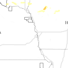
South Dakota
| Local Time | Report Details |
|---|---|
| 3:49 PM CDT | Quarter sized hail reported near Utica, SD, 55.4 miles SW of Sioux Falls, SD |
| 4:09 PM CDT | Ping Pong Ball sized hail reported near Wakonda, SD, 39 miles SSW of Sioux Falls, SD, delayed report via social media. |
| 3:18 PM MDT | Golf Ball sized hail reported near Piedmont, SD, 13.8 miles NW of Rapid City, SD |
| 3:50 PM MDT | Quarter sized hail reported near Black Hawk, SD, 8.7 miles NW of Rapid City, SD |
| 5:05 PM CDT | Quarter sized hail reported near Alcester, SD, 41.2 miles SSE of Sioux Falls, SD, picture received through social media. |
| 4:15 PM MDT | Quarter sized hail reported near Rapid City, SD, 2.5 miles NW of Rapid City, SD, knbn |
| 4:16 PM MDT | Golf Ball sized hail reported near Rapid City, SD, 8.1 miles WNW of Rapid City, SD |
| 4:17 PM MDT | Ping Pong Ball sized hail reported near Rapid City, SD, 3.7 miles WNW of Rapid City, SD, mping report |
| 4:20 PM MDT | Quarter sized hail reported near Rapid City, SD, 2.5 miles WNW of Rapid City, SD |
| 4:20 PM MDT | Hen Egg sized hail reported near Rapid City, SD, 1.9 miles NW of Rapid City, SD, elongated hail stone |
| 5:34 PM MDT | Golf Ball sized hail reported near Nemo, SD, 15.8 miles WNW of Rapid City, SD |
| 5:35 PM MDT | Ping Pong Ball sized hail reported near Rapid City, SD, 4.2 miles S of Rapid City, SD |
| 5:45 PM MDT | Hen Egg sized hail reported near Rapid City, SD, 6.6 miles SSW of Rapid City, SD, reptile gardens |
| 5:45 PM MDT | Ping Pong Ball sized hail reported near Rapid City, SD, 7.4 miles SSW of Rapid City, SD |
| 5:49 PM MDT | Baseball sized hail reported near Rapid City, SD, 8.4 miles S of Rapid City, SD |
| 6:04 PM MDT | Ping Pong Ball sized hail reported near Hermosa, SD, 17.4 miles S of Rapid City, SD, mping report |
| 6:16 PM MDT | Quarter sized hail reported near Hill City, SD, 21.4 miles W of Rapid City, SD, mostly pea size hail |
| 6:33 PM MDT | Quarter sized hail reported near Hermosa, SD, 16.7 miles S of Rapid City, SD |
| 7:05 PM MDT | Storm damage reported in custer county SD, 29.1 miles SSE of Rapid City, SD |
| 7:45 PM MDT | Golf Ball sized hail reported near Custer, SD, 24.2 miles SW of Rapid City, SD |
| 9:25 PM MDT | Storm damage reported in fall river county SD, 56.1 miles SW of Rapid City, SD |
| 10:01 PM MDT | Storm damage reported in fall river county SD, 62.6 miles S of Rapid City, SD |
| 10:11 PM MDT | Storm damage reported in fall river county SD, 62.6 miles S of Rapid City, SD |
| 11:39 PM CDT | Golf Ball sized hail reported near Florence, SD, 60.3 miles ESE of Aberdeen, SD, approximate time and location. |
| 11:52 PM CDT | Quarter sized hail reported near Garretson, SD, 16.7 miles NE of Sioux Falls, SD, report via social media. |
| 10:57 PM MDT | Storm damage reported in pennington county SD, 55.1 miles ESE of Rapid City, SD |
| 11:05 PM MDT | Storm damage reported in pennington county SD, 37.1 miles ESE of Rapid City, SD |
| 11:22 PM MDT | Storm damage reported in jackson county SD, 72.3 miles ESE of Rapid City, SD |
| 11:27 PM MDT | Storm damage reported in jackson county SD, 72.3 miles ESE of Rapid City, SD |
| 11:30 PM MDT | Storm damage reported in jackson county SD, 69.3 miles E of Rapid City, SD |
| 11:37 PM MDT | Storm damage reported in jackson county SD, 72.3 miles ESE of Rapid City, SD |
| 11:41 PM MDT | Storm damage reported in oglala lakota county SD, 72.8 miles SE of Rapid City, SD |
| 11:44 PM MDT | Storm damage reported in haakon county SD, 65.9 miles WSW of Pierre, SD |
| 11:47 PM MDT | Storm damage reported in jackson county SD, 72.3 miles ESE of Rapid City, SD |
| 11:56 PM MDT | Storm damage reported in jackson county SD, 49.4 miles SW of Pierre, SD |
| 12:02 AM MDT | Storm damage reported in jackson county SD, 72.3 miles ESE of Rapid City, SD |
| 12:12 AM MDT | Storm damage reported in jackson county SD, 72.3 miles ESE of Rapid City, SD |
| 3:41 AM CDT | Mesonet station 201 gann valley (sddot in buffalo county SD, 70.4 miles ESE of Pierre, SD |
Arkansas
| Local Time | Report Details |
|---|---|
| 4:25 PM CDT | Trees blown down in stor in montgomery county AR, 55.1 miles NNE of Nashville, AR |
| 5:45 PM CDT | Tree blown down along hot springs cree in garland county AR, 47.4 miles WSW of Little Rock, AR |
Maryland
| Local Time | Report Details |
|---|---|
| 5:32 PM EDT | Multiple trees down due to thunderstorm winds in the potomac heights are in charles county MD, 55 miles SSW of Baltimore, MD |
| 5:34 PM EDT | Multiple trees down due to thunderstorm winds in the bryans road are in charles county MD, 52.7 miles SSW of Baltimore, MD |
| 5:52 PM EDT | A couple trees and power lines down near waldor in charles county MD, 47.5 miles SSW of Baltimore, MD |
| 6:23 PM EDT | Two trees down on 5th street near boyds turn roa in calvert county MD, 40.9 miles S of Baltimore, MD |
| 6:44 PM EDT | Wunderground station kmdtilgh14 measured wind gust before power went out on tilghman island. likely microburs in talbot county MD, 43.2 miles SSE of Baltimore, MD |
| 6:44 PM EDT | Received reports from talbot county emergency management of boats flipped over... trees down on houses and numerous trees and wires down across much of tilghman islan in talbot county MD, 42.1 miles SSE of Baltimore, MD |
| 6:48 PM EDT | Weatherflow station xbwh at blackwalnut harbor measured a thunderstorm wind gust of 51kt/59mp in anz541 county MD, 44.7 miles SSE of Baltimore, MD |
| 7:16 PM EDT | Co-op observer relayed a picture of an overturned tractor trailer on the choptank river bridge on us 50. time estimated via rada in talbot county MD, 55.2 miles WNW of Ocean City, MD |
| 7:24 PM EDT | Buoy station camm2 cambridge... m in dorchester county MD, 55.9 miles WNW of Ocean City, MD |
| 7:24 PM EDT | Truck overturned on us 50 choptank river bridge. time estimate in dorchester county MD, 55.5 miles WNW of Ocean City, MD |
| 7:31 PM EDT | A tree fell down near morgan mill rd and loch raven d in baltimore county MD, 11.5 miles NNE of Baltimore, MD |
| 7:36 PM EDT | One tree into a house due to thunderstorm winds along the 1900 block of haverhill roa in baltimore county MD, 15 miles NW of Baltimore, MD |
| 7:36 PM EDT | One tree into a house due to thunderstorm winds along the 1900 block of haverhill roa in baltimore county MD, 8.8 miles NNE of Baltimore, MD |
| 7:37 PM EDT | One tree down onto a utility pole at the intersection of glen arm road and cromwell bridge road due to thunderstorm wind in baltimore county MD, 9.3 miles NNE of Baltimore, MD |
| 7:40 PM EDT | Tree down on sunshine ave near harford road. tree also down on mt vista road near glen arm road. numerous branches down nearb in baltimore county MD, 15.3 miles NE of Baltimore, MD |
| 7:40 PM EDT | A tree fell down near belair rd and miller r in baltimore county MD, 12.4 miles NE of Baltimore, MD |
| 8:29 PM EDT | One tree down due to thunderstorm winds along little egypt roa in cecil county MD, 51.7 miles ENE of Baltimore, MD |
Georgia
| Local Time | Report Details |
|---|---|
| 5:33 PM EDT | Quarter sized hail reported near Woodbine, GA, 40.7 miles N of Jacksonville, FL, a spotter observed quarter size hail near the intersection of colesburg tompkins road and us highway 17. |
Connecticut
| Local Time | Report Details |
|---|---|
| 5:48 PM EDT | Downed powerline by tree limbs on silver spring l in fairfield county CT, 45.7 miles NE of Brooklyn, NY |
| 5:48 PM EDT | Tree down across ruscoe r in fairfield county CT, 45.4 miles NE of Brooklyn, NY |
| 9:36 PM EDT | Downed trees on burr s in fairfield county CT, 50.1 miles NE of Brooklyn, NY |
Iowa
| Local Time | Report Details |
|---|---|
| 5:07 PM CDT | Quarter sized hail reported near Hawarden, IA, 39.7 miles SSE of Sioux Falls, SD, quarter sized hail in the southwest part of town. |
| 5:45 PM CDT | Golf Ball sized hail reported near Aurelia, IA, 12.2 miles NW of Storm Lake, IA, ground is covered while with golf ball sized hail... and row crops are badly damaged. |
| 5:53 PM CDT | Quarter sized hail reported near Aurelia, IA, 12.9 miles WNW of Storm Lake, IA, photo from social media. |
| 6:37 PM CDT | Quarter sized hail reported near Rockwell City, IA, 31.1 miles ESE of Storm Lake, IA |
Utah
| Local Time | Report Details |
|---|---|
| 4:10 PM MDT | Mesonet station dpg06 14.0 sw dugway (dugway) station elevation: 5077 f in tooele county UT, 71.3 miles SW of Salt Lake City, UT |
| 4:20 PM MDT | Mesonet station dpg07 english village (dugway) station elevation: 4788 f in tooele county UT, 57.5 miles SW of Salt Lake City, UT |
| 4:40 PM MDT | Mesonet station pc348 tintic station elevation: 6575 f in utah county UT, 56.3 miles SSW of Salt Lake City, UT |
| 4:40 PM MDT | Mesonet station utjps 5.4 w clover (utah dot) station elevation: 6520 f in tooele county UT, 46.1 miles SW of Salt Lake City, UT |
| 4:45 PM MDT | Mesonet station up106 5.4 se clover (upr) station elevation: 5052 f in tooele county UT, 43.2 miles SW of Salt Lake City, UT |
| 4:50 PM MDT | Mesonet station pc195 eureka ridge station elevation: 7872 f in juab county UT, 57.7 miles SSW of Salt Lake City, UT |
| 4:58 PM MDT | Mesonet station arau1 aragonite station elevation: 5029 f in tooele county UT, 60.5 miles W of Salt Lake City, UT |
| 5:00 PM MDT | Mesonet station utedl 1.5 se delle (utah dot) station elevation: 4228 f in tooele county UT, 45.8 miles W of Salt Lake City, UT |
| 5:10 PM MDT | Many large branches and trees down in genol in utah county UT, 51.1 miles S of Salt Lake City, UT |
| 5:15 PM MDT | Mesonet station kcc02 5.6 ne lake pt (kennecott) station elevation: 4220 f in salt lake county UT, 16.5 miles W of Salt Lake City, UT |
| 5:15 PM MDT | Large tree down including a large root bal in utah county UT, 49.5 miles S of Salt Lake City, UT |
| 5:20 PM MDT | Mesonet station utbrc 2.8 n payson (utah dot) station elevation: 4528 f in utah county UT, 48.4 miles S of Salt Lake City, UT |
| 5:20 PM MDT | Mesonet station fg009 0.9 n santaquin (fgnet) station elevation: 4899 f in utah county UT, 53.4 miles S of Salt Lake City, UT |
| 5:20 PM MDT | Mesonet station utlak 7.6 se fairfield (utah dot) station elevation: 4678 f in utah county UT, 40 miles S of Salt Lake City, UT |
| 5:20 PM MDT | Mesonet station ut201 sr-201 at i-80 station elevation: 4271 f in tooele county UT, 18.2 miles W of Salt Lake City, UT |
| 5:20 PM MDT | Mesonet station fg024 1.8 nw santaquin (fgnet) station elevation: 4791 f in utah county UT, 52.6 miles S of Salt Lake City, UT |
| 5:20 PM MDT | Mesonet station ut107 i-80 at mp 107 station elevation: 4225 f in salt lake county UT, 13.8 miles W of Salt Lake City, UT |
| 5:24 PM MDT | Power poles down... multiple trees uproote in utah county UT, 50.3 miles SSE of Salt Lake City, UT |
| 5:30 PM MDT | Powerlines dow in salt lake county UT, 7.2 miles SSW of Salt Lake City, UT |
| 5:30 PM MDT | Mesonet station utprb sr-131 at mp 0.5 porter rockwell station elevation: 4516 f in salt lake county UT, 20.8 miles S of Salt Lake City, UT |
| 5:30 PM MDT | Mesonet station utbrc 2.8 n payson (utah dot) station elevation: 4528 f in utah county UT, 48.4 miles S of Salt Lake City, UT |
| 5:30 PM MDT | Report from mping: 1-inch tree limbs broken; shingles blown of in salt lake county UT, 18.6 miles SSW of Salt Lake City, UT |
| 5:30 PM MDT | Mesonet station utalp 2.9 se bluffdale (utah dot) station elevation: 4795 f in utah county UT, 21.4 miles S of Salt Lake City, UT |
| 5:34 PM MDT | Asos station kslc salt lake city intl arpt station elevation: 4225 f in salt lake county UT, 4.4 miles W of Salt Lake City, UT |
| 5:34 PM MDT | Asos station kslc salt lake city intl arpt station elevation: 4225 f in salt lake county UT, 4.4 miles W of Salt Lake City, UT |
| 5:40 PM MDT | 3 to 4 inch tree limbs broke in utah county UT, 46.5 miles SSE of Salt Lake City, UT |
| 5:45 PM MDT | Tree snapped near bas in salt lake county UT, 10.4 miles S of Salt Lake City, UT |
| 5:45 PM MDT | Large light pole dow in davis county UT, 8.4 miles N of Salt Lake City, UT |
| 5:45 PM MDT | Roof blown off manufactured hom in weber county UT, 29.5 miles N of Salt Lake City, UT |
| 5:45 PM MDT | Tree down in santaqui in utah county UT, 54.1 miles S of Salt Lake City, UT |
| 5:50 PM MDT | Mesonet station utdcd 3.3 ne sundance (utah dot) station elevation: 5429 f in wasatch county UT, 30.6 miles SE of Salt Lake City, UT |
| 6:00 PM MDT | Mesonet station mby 3.3 s park city (deervly) station elevation: 9347 f in wasatch county UT, 23.8 miles ESE of Salt Lake City, UT |
| 6:00 PM MDT | Mesonet station hdp 0.7 se snowbird (snowbird) station elevation: 10994 f in utah county UT, 19 miles SE of Salt Lake City, UT |
| 6:00 PM MDT | Mesonet station iff 1.7 n snowbird (avalanche) station elevation: 10059 f in salt lake county UT, 17.1 miles SE of Salt Lake City, UT |
| 6:00 PM MDT | Tree snapped at bas in davis county UT, 15.2 miles N of Salt Lake City, UT |
| 6:04 PM MDT | Report from mping: 1-inch tree limbs broken; shingles blown of in wasatch county UT, 27.5 miles SE of Salt Lake City, UT |
| 6:05 PM MDT | 6 inch limbs snapped off tree in weber county UT, 29.9 miles N of Salt Lake City, UT |
| 6:06 PM MDT | Trees reported down in midwa in wasatch county UT, 26.7 miles SE of Salt Lake City, UT |
| 6:06 PM MDT | Power lines down in morga in morgan county UT, 22.5 miles NNE of Salt Lake City, UT |
| 6:06 PM MDT | Large... healthy tree snapped near the base at heber city police statio in wasatch county UT, 30.5 miles SE of Salt Lake City, UT |
| 6:20 PM MDT | Mesonet station pc063 brown's canyon station elevation: 6623 f in summit county UT, 24.4 miles E of Salt Lake City, UT |
| 6:20 PM MDT | Mesonet station pc298 the head station elevation: 8539 f in morgan county UT, 27.4 miles NNE of Salt Lake City, UT |
| 6:20 PM MDT | Mesonet station ut33 11.5 w knolls (utah dot) station elevation: 4223 f in tooele county UT, 84.6 miles W of Salt Lake City, UT |
| 6:30 PM MDT | Mesonet station utkno i-80 at mp 40 knolls station elevation: 4243 f in tooele county UT, 73.1 miles W of Salt Lake City, UT |
New Mexico
| Local Time | Report Details |
|---|---|
| 5:01 PM MDT | Storm damage reported in lea county NM, 81.5 miles NW of Odessa, TX |
New Jersey
| Local Time | Report Details |
|---|---|
| 9:02 PM EDT | Trees down on wires at the sea pine campground near the swainton section of middle twp. time estimated from radar. report relayed via medi in cape may county NJ, 57.1 miles NNE of Ocean City, MD |
| 9:49 PM EDT | Received video of a shed flipped on its side near the intersection of rte 40 and pole tavern circle. time estimated via rada in salem county NJ, 77 miles ENE of Baltimore, MD |
| 9:52 PM EDT | Reports of several trees down in upper pittsgrove twp near the intersection of swedesboro road and rte 77. time estimated via rada in salem county NJ, 78.3 miles ENE of Baltimore, MD |
Minnesota
| Local Time | Report Details |
|---|---|
| 8:33 PM CDT | Quarter sized hail reported near Hastings, MN, 26.2 miles SE of Minneapolis, MN, photo of hail compared to quarter. |
| 8:45 PM CDT | Ping Pong Ball sized hail reported near Farmington, MN, 20.3 miles S of Minneapolis, MN |
| 8:52 PM CDT | Quarter sized hail reported near Farmington, MN, 23 miles SSE of Minneapolis, MN |
| 8:55 PM CDT | Golf Ball sized hail reported near Farmington, MN, 19.6 miles S of Minneapolis, MN, biggest hail from 855pm to 905pm. between 1.5-2 inches. |
| 9:08 PM CDT | Quarter sized hail reported near Lakeville, MN, 20.8 miles S of Minneapolis, MN |
| 9:10 PM CDT | Ping Pong Ball sized hail reported near Farmington, MN, 22.4 miles S of Minneapolis, MN, maximum size with most hail smaller. |
Nebraska
| Local Time | Report Details |
|---|---|
| 9:07 PM MDT | Estimated 60 mph wind gus in sioux county NE, 58.2 miles N of Scottsbluff, NE |
| 9:44 PM MDT | Asos station kcdr chadron airport - cd in dawes county NE, 72.8 miles NNE of Scottsbluff, NE |
| 9:49 PM MDT | Chadron aso in dawes county NE, 75 miles NNE of Scottsbluff, NE |
Connect with Interactive Hail Maps