

Hail Map for Tuesday, July 4, 2023

Number of Impacted Households on 7/4/2023
0
Impacted by 1" or Larger Hail
0
Impacted by 1.75" or Larger Hail
0
Impacted by 2.5" or Larger Hail
Square Miles of Populated Area Impacted on 7/4/2023
0
Impacted by 1" or Larger Hail
0
Impacted by 1.75" or Larger Hail
0
Impacted by 2.5" or Larger Hail


Cities Most Affected by Hail Storms of 7/4/2023
| Hail Size | Demographics of Zip Codes Affected | ||||||
|---|---|---|---|---|---|---|---|
| City | Count | Average | Largest | Pop Density | House Value | Income | Age |
| Kensington, KS | 2 | 1.75 | 1.75 | 3 | $36k | $30.4k | 48.0 |
| Waco, NE | 2 | 1.75 | 1.75 | 8 | $56k | $37.7k | 49.4 |
| Sutton, NE | 2 | 1.75 | 1.75 | 8 | $62k | $35.2k | 43.4 |
| Carleton, NE | 1 | 2.50 | 2.50 | 3 | $62k | $41.7k | 44.4 |
| Campbell, NE | 1 | 2.50 | 2.50 | 2 | $22k | $25.8k | 48.7 |
| Humphrey, NE | 1 | 2.00 | 2.00 | 7 | $82k | $38.0k | 41.1 |
| Hoxie, KS | 1 | 2.00 | 2.00 | 2 | $59k | $33.9k | 48.2 |
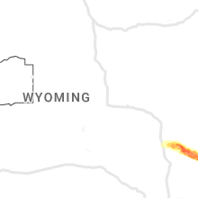
| Torrington, WY | 1 | 1.75 | 1.75 | 13 | $79k | $33.0k | 43.0 |
| Monroe, NE | 1 | 1.75 | 1.75 | 6 | $63k | $38.6k | 44.7 |
| Colorado Springs, CO | 1 | 1.75 | 1.75 | 2683 | $126k | $47.2k | 33.1 |
| Emerson, NE | 1 | 1.75 | 1.75 | 8 | $55k | $36.2k | 44.8 |
| Fort Laramie, WY | 1 | 1.75 | 1.75 | 1 | $57k | $26.9k | 52.0 |
Hail and Wind Damage Spotted on 7/4/2023
Filter by Report Type:Hail ReportsWind Reports
States Impacted
Wyoming, Wisconsin, Florida, New Hampshire, New Jersey, Rhode Island, Vermont, Iowa, Colorado, New York, Mississippi, Texas, South Carolina, Nebraska, Kansas, Illinois, Alabama, North Carolina, MissouriWyoming
| Local Time | Report Details |
|---|---|
| 8:46 AM MDT | Mesonet station wy8 2.2 w church buttes (wydot). outflow from a decaying thunderstor in uinta county WY, 47.8 miles WSW of Rock Springs, WY |
| 2:26 PM MDT | Golf Ball sized hail reported near Fort Laramie, WY, 47.8 miles WNW of Scottsbluff, NE, emergency manager reported golf ball sized hail. |
| 2:40 PM MDT | Emergency manager reports structure and tree damage at road 60 and road 3 in goshen county WY, 33.1 miles WNW of Scottsbluff, NE |
| 2:43 PM MDT | Emergency managers reports flipped pivot at wy 154 and rd 6 in goshen county WY, 36.2 miles WNW of Scottsbluff, NE |
| 2:43 PM MDT | Ping Pong Ball sized hail reported near Torrington, WY, 36.2 miles WNW of Scottsbluff, NE, emergency manager reports hail on ground measured 1.25 to 1.5 inches. same location as flipped pivot. |
| 2:48 PM MDT | Ping Pong Ball sized hail reported near Yoder, WY, 32.6 miles W of Scottsbluff, NE, emergency manager reports wind driven hail knocked out windows in yoder... wy. estimated size is 1.5. |
| 2:58 PM MDT | Quarter sized hail reported near Torrington, WY, 23.8 miles WNW of Scottsbluff, NE, emergency manager reports quarter sized hail. |
| 3:05 PM MDT | Golf Ball sized hail reported near Torrington, WY, 24.4 miles W of Scottsbluff, NE |
Wisconsin
| Local Time | Report Details |
|---|---|
| 11:30 AM CDT | Trained spotter reported large tree branches down causing damage to fenc in st. croix county WI, 37.4 miles ENE of Minneapolis, MN |
| 6:55 PM CDT | Facebook photo of an uprooted tree in duran in pepin county WI, 66.8 miles NNW of La Crosse, WI |
Florida
| Local Time | Report Details |
|---|---|
| 12:03 PM CDT | Tree down partially across the road on highway 6 in calhoun county FL, 45.2 miles W of Tallahassee, FL |
| 4:50 PM EDT | Tree fell on a power line off county road 210. time estimated by rada in st. johns county FL, 20.6 miles SSE of Jacksonville, FL |
| 5:35 PM EDT | Tree fell on a power line off of county road 210w. time estimated by rada in st. johns county FL, 40.1 miles SSE of Jacksonville, FL |
| 5:56 PM EDT | Corrects previous tstm wnd dmg report from 2 n spuds. tree fell on a power line off of county road 13s. time estimated by rada in st. johns county FL, 40.1 miles SSE of Jacksonville, FL |
| 5:56 PM EDT | Corrects previous tstm wnd dmg report from 2 n spuds. tree fell on a power line off of county road 13s. time estimated by rada in st. johns county FL, 40.1 miles SSE of Jacksonville, FL |
New Hampshire
| Local Time | Report Details |
|---|---|
| 1:45 PM EDT | Reported by amateur radio. social media photos of a tree down on the parking lot of dollar general and a tree that was partially blocking route 3 near north country pow in coos county NH, 84.1 miles E of Burlington, VT |
| 3:30 PM EDT | Reported by amateur radio. reports of a few downed trees and large branches on north side of colebrook. tree down on hughes road near the iga. time estimated by rada in coos county NH, 90 miles ENE of Burlington, VT |
| 8:30 PM EDT | Quarter sized hail reported near Cornish, NH, 79.1 miles SSE of Burlington, VT, reported by amateur radio. |
| 8:35 PM EDT | Quarter sized hail reported near Claremont, NH, 85.4 miles SSE of Burlington, VT, reported by weather spotter. |
| 8:43 PM EDT | Observed trees down on nh highway 114. time estimated by rada in merrimack county NH, 86.7 miles WSW of Portland, ME |
New Jersey
| Local Time | Report Details |
|---|---|
| 2:40 PM EDT | Picture shared on social media of a gas station canopy blown over on route 22 near rock avenue in north plainfield. time estimated from rada in somerset county NJ, 25.3 miles WSW of Brooklyn, NY |
| 3:40 PM EDT | Poles and wires down in parts of upper freehold. power outages. time estimated from rada in monmouth county NJ, 46.3 miles SW of Brooklyn, NY |
| 4:05 PM EDT | Tree onto power lines on west millstream road. power outages reported. time estimated from rada in ocean county NJ, 48.9 miles SSW of Brooklyn, NY |
| 4:20 PM EDT | Couple of trees down in the springfield township and jobstown areas. time estimated from rada in burlington county NJ, 58.2 miles SW of Brooklyn, NY |
| 4:47 PM EDT | Quarter sized hail reported near Mount Holly, NJ, 63.2 miles SW of Brooklyn, NY, hail estimated to be quarter size in westampton township in the deerwood area. time estimated from radar. |
| 4:55 PM EDT | Tree down on landing street in lumberton. time estimated from rada in burlington county NJ, 66 miles SW of Brooklyn, NY |
| 5:10 PM EDT | Tree down onto wires near union mill road. time estimated from rada in burlington county NJ, 70.4 miles SW of Brooklyn, NY |
| 5:50 PM EDT | Trees down at marlton parkway and sagemore drive. time estimated from rada in burlington county NJ, 74.5 miles SW of Brooklyn, NY |
| 5:50 PM EDT | Some trees down. time estimated from rada in burlington county NJ, 73.9 miles SW of Brooklyn, NY |
| 6:05 PM EDT | Estimated 60 mph wind gust. time estimated from rada in camden county NJ, 80.7 miles SW of Brooklyn, NY |
| 6:12 PM EDT | Estimated 50 to 60 mph wind gusts on interstate 295 southbound by woodcrest station. small branches flying onto the roadway. time estimated from rada in camden county NJ, 78.1 miles SW of Brooklyn, NY |
| 6:14 PM EDT | Trees... wires... and numerous large branches down; street flooding; navigation difficul in camden county NJ, 77.5 miles SW of Brooklyn, NY |
| 6:18 PM EDT | Tree down on cedar ave. time estimated by rada in gloucester county NJ, 83.2 miles SW of Brooklyn, NY |
| 6:30 PM EDT | Tree down on highland ave. time estimated by rada in gloucester county NJ, 82.7 miles SW of Brooklyn, NY |
Rhode Island
| Local Time | Report Details |
|---|---|
| 2:50 PM EDT | Tree down near park plaza apartments in johnston. police and ems on scene as injuries were reported though unclear how many were injured or the extent of injuries. time in providence county RI, 4.4 miles WSW of Providence, RI |
Vermont
| Local Time | Report Details |
|---|---|
| 2:53 PM EDT | Multiple trees down across the town of east hardwick in caledonia county VT, 44.7 miles E of Burlington, VT |
| 4:30 PM EDT | Quarter sized hail reported near Alburgh, VT, 35.1 miles N of Burlington, VT |
| 4:54 PM EDT | One tree down in the park... multiple trees down on east shore road in grand isle county VT, 15.3 miles NNW of Burlington, VT |
| 5:40 PM EDT | Quarter sized hail reported near Morrisville, VT, 30.8 miles E of Burlington, VT, dime to quarter sized hail |
| 5:50 PM EDT | Quarter sized hail reported near Morrisville, VT, 30.8 miles E of Burlington, VT, dime to quarter sized hail |
| 6:06 PM EDT | Trees down in orange county VT, 66.1 miles SE of Burlington, VT |
| 6:09 PM EDT | Additional trees down from second line of storms... south of east hardwick per certified spotte in caledonia county VT, 44.7 miles E of Burlington, VT |
| 8:30 PM EDT | Quarter sized hail reported near Windsor, VT, 80.7 miles SSE of Burlington, VT, time estimated by radar. |
Iowa
| Local Time | Report Details |
|---|---|
| 2:50 PM CDT | Social media photo of several large limbs broken off tree in plymouth county IA, 57.1 miles W of Storm Lake, IA |
| 3:02 PM CDT | Several large tree branches snapped off. one section of tree branch was thrown into hous in plymouth county IA, 50.4 miles W of Storm Lake, IA |
| 5:56 PM CDT | Older tree down across the road near the intersection of dogwood trail and port neal roa in woodbury county IA, 61.5 miles WSW of Storm Lake, IA |
Colorado
| Local Time | Report Details |
|---|---|
| 1:53 PM MDT | Quarter sized hail reported near Colorado Springs, CO, 41.5 miles N of Pueblo, CO |
| 1:53 PM MDT | Quarter sized hail reported near Colorado Springs, CO, 40.9 miles N of Pueblo, CO |
| 1:54 PM MDT | Golf Ball sized hail reported near Colorado Springs, CO, 42.2 miles N of Pueblo, CO |
| 1:55 PM MDT | Quarter sized hail reported near Colorado Springs, CO, 42.9 miles N of Pueblo, CO |
| 2:30 PM MDT | Quarter sized hail reported near Colorado Springs, CO, 34.2 miles N of Pueblo, CO |
| 4:28 PM MDT | Quarter sized hail reported near Sugar City, CO, 51.8 miles E of Pueblo, CO |
| 4:40 PM MDT | Quarter sized hail reported near Manitou Springs, CO, 44.2 miles NNW of Pueblo, CO |
| 5:14 PM MDT | Quarter sized hail reported near La Junta, CO, 73.3 miles ESE of Pueblo, CO |
| 5:40 PM MDT | Storm damage reported in larimer county CO, 26.4 miles SSW of Laramie, WY |
| 6:05 PM MDT | Corrects time of previous tstm wnd gst report from 11 nne kremmling. mesonet station gspc2 gunsigh in grand county CO, 67.6 miles ESE of Craig, CO |
| 6:46 PM MDT | Mesonet station gspc2 gunsigh in grand county CO, 67.6 miles ESE of Craig, CO |
| 6:47 PM MDT | Quarter sized hail reported near Colorado Springs, CO, 39.2 miles NNW of Pueblo, CO |
| 8:17 PM MDT | Mesonet station co218 aurora i-70/tower r in adams county CO, 11.9 miles E of Denver, CO |
| 8:20 PM MDT | Mesonet station e470i smith roa in adams county CO, 14.5 miles E of Denver, CO |
| 8:23 PM MDT | Report from mping: 1-inch tree limbs broken; shingles blown of in adams county CO, 11.8 miles E of Denver, CO |
| 8:26 PM MDT | Mesonet station ur415 aurora i-70/gun club r in adams county CO, 15.6 miles E of Denver, CO |
New York
| Local Time | Report Details |
|---|---|
| 4:06 PM EDT | Trees and powerlines down in essex county NY, 31.4 miles SSW of Burlington, VT |
| 4:30 PM EDT | Powerlines down in essex county NY, 37.1 miles SW of Burlington, VT |
| 4:38 PM EDT | Tree down and branches on power lines. power out in clinton county NY, 22.1 miles NNW of Burlington, VT |
| 4:47 PM EDT | Tree down and branches on power lines. power out. corrected report after additional radar review of downburst signature occurring near point au roch in clinton county NY, 22.1 miles NNW of Burlington, VT |
| 5:50 PM EDT | Trees down in essex county NY, 11.8 miles SW of Burlington, VT |
| 6:05 PM EDT | Powerlines dow in essex county NY, 14.4 miles SSW of Burlington, VT |
| 7:14 PM EDT | Downed trees and wires on king road and route 67 in washington county NY, 27.4 miles ENE of Schenectady, NY |
| 7:18 PM EDT | 100 foot pine tree down on a house on route 67 moving eastbound just passed buskirk seventh-day adventist church in rensselaer county NY, 27.6 miles ENE of Schenectady, NY |
| 7:25 PM EDT | Multiple trees downed on route 147 between galway and glenville in saratoga county NY, 11.8 miles NNW of Schenectady, NY |
| 8:12 PM EDT | Wires donw on a shed on 5 velina drive in guilderland in albany county NY, 8.8 miles SSE of Schenectady, NY |
| 8:40 PM EDT | Route 9j and knickerbocker road closed due to multiple downed tree in rensselaer county NY, 23.9 miles SSE of Schenectady, NY |
| 8:40 PM EDT | Multiple trees down on main street in albany county NY, 24.7 miles SSE of Schenectady, NY |
| 8:40 PM EDT | Tree and wires downed on biechman road in albany county NY, 24.6 miles S of Schenectady, NY |
| 8:42 PM EDT | Tree leaning on wires in oakbrook manor on route 9w in albany county NY, 24.4 miles SSE of Schenectady, NY |
| 8:45 PM EDT | Route 144 closed on the albany/greene county line due to multiple downed tree in greene county NY, 26.2 miles SSE of Schenectady, NY |
| 8:55 PM EDT | Trees downed on eichybush road in columbia county NY, 29 miles SSE of Schenectady, NY |
| 8:56 PM EDT | Trees downed at the intesection of ridge road and state route 9j. state route 9j closed due to downed trees from the rensselaer county border down to state route 9 in s in columbia county NY, 25.8 miles SSE of Schenectady, NY |
| 8:56 PM EDT | Multiple trees and wires down on roadways in columbia county NY, 29.1 miles SSE of Schenectady, NY |
| 8:56 PM EDT | Tree down at 1094 route 9j in columbia county NY, 30.3 miles SSE of Schenectady, NY |
| 8:57 PM EDT | Trees downed on hollow road in columbia county NY, 29.3 miles SSE of Schenectady, NY |
| 9:02 PM EDT | Multiple trees down in kinderhook in columbia county NY, 31.6 miles SSE of Schenectady, NY |
| 9:05 PM EDT | Tree limbs downed on route 9h in columbia county NY, 32.9 miles SSE of Schenectady, NY |
| 9:14 PM EDT | Trees downed on george road in the town of ghent in columbia county NY, 37.1 miles SSE of Schenectady, NY |
| 9:24 PM EDT | Wires down on orchard road in columbia county NY, 37.6 miles SSE of Schenectady, NY |
Mississippi
| Local Time | Report Details |
|---|---|
| 3:13 PM CDT | Tree down on grady roa in webster county MS, 30.7 miles W of Starkville, MS |
Texas
| Local Time | Report Details |
|---|---|
| 3:23 PM CDT | Quarter sized hail reported near Sanger, TX, 45 miles NNW of Dallas, TX, quarter size hail reported near sanger. |
South Carolina
| Local Time | Report Details |
|---|---|
| 4:47 PM EDT | Beaufort marine corps air station gusted to 50 knots (58 mph in beaufort county SC, 36.3 miles NE of Savannah, GA |
| 5:02 PM EDT | 1 tree down at wild turkey ln and cottageville hw in colleton county SC, 31.3 miles SW of Charleston, SC |
| 7:00 PM EDT | Tree down on perry hill roa in pickens county SC, 3.5 miles E of Greenville, SC |
| 7:00 PM EDT | Trees down off emory driv in pickens county SC, 4.6 miles E of Greenville, SC |
| 7:00 PM EDT | Trees down off emory driv in pickens county SC, 4.6 miles E of Greenville, SC |
| 7:00 PM EDT | Trees on roadway of old easley highway in front of greenville pickens speedwa in pickens county SC, 5.7 miles E of Greenville, SC |
| 7:28 PM EDT | Tree down on roadwa in greenville county SC, 8.5 miles E of Greenville, SC |
| 7:33 PM EDT | Trees down on kmart plaza at marue driv in greenville county SC, 10.3 miles E of Greenville, SC |
Nebraska
| Local Time | Report Details |
|---|---|
| 3:48 PM CDT | Storm damage reported in platte county NE, 58.5 miles NE of Grand Island, NE |
| 3:07 PM MDT | Quarter sized hail reported near Lyman, NE, 19.9 miles WNW of Scottsbluff, NE |
| 4:15 PM CDT | Quarter sized hail reported near Humphrey, NE, 68.9 miles NE of Grand Island, NE |
| 4:24 PM CDT | Half Dollar sized hail reported near Humphrey, NE, 69.2 miles NE of Grand Island, NE |
| 4:24 PM CDT | Hen Egg sized hail reported near Humphrey, NE, 69.2 miles NE of Grand Island, NE, social media photo of hail stone in humphrey. |
| 3:36 PM MDT | Half Dollar sized hail reported near Lyman, NE, 14.7 miles WSW of Scottsbluff, NE, report from mping: half dollar (1.25 in.). |
| 4:45 PM CDT | Quarter sized hail reported near Madison, NE, 70.4 miles ESE of Oneill, NE, relayed via social media. |
| 4:57 PM CDT | Quarter sized hail reported near Madison, NE, 70.4 miles ESE of Oneill, NE, report from mping. |
| 4:58 PM CDT | Half Dollar sized hail reported near Platte Center, NE, 64.4 miles NE of Grand Island, NE, from spotter network. |
| 5:09 PM CDT | Tree limbs up to 2 inch diameter dow in dixon county NE, 71.7 miles S of Sioux Falls, SD |
| 5:22 PM CDT | Golf Ball sized hail reported near Monroe, NE, 53.9 miles NE of Grand Island, NE |
| 5:32 PM CDT | Tree limbs up to 3 inches in diameter broke in dakota county NE, 73.3 miles W of Storm Lake, IA |
| 5:45 PM CDT | Quarter sized hail reported near Silver Creek, NE, 44.3 miles NE of Grand Island, NE, dime to quarter size hail falling in silver creek. |
| 5:49 PM CDT | Quarter sized hail reported near Emerson, NE, 80.1 miles NNW of Omaha, NE, report from mping: quarter (1.00 in.). |
| 5:54 PM CDT | Golf Ball sized hail reported near Emerson, NE, 80.7 miles NNW of Omaha, NE, delayed report. photo relayed via social media. golf ball sized hail lasted a minute or two. some damage to vehicles... crops... and flowers. |
| 6:03 PM CDT | Relayed via social media. measured on personal weather statio in butler county NE, 58.6 miles W of Omaha, NE |
| 6:15 PM CDT | Quarter sized hail reported near Shelby, NE, 53.6 miles ENE of Grand Island, NE, reported hail up to the size of quarters. |
| 6:17 PM CDT | Measured on personal weather statio in butler county NE, 58.8 miles W of Omaha, NE |
| 6:27 PM CDT | Tennis Ball sized hail reported near Campbell, NE, 48.8 miles SSW of Grand Island, NE, social media report of tennis ball size hail. |
| 6:36 PM CDT | Half Dollar sized hail reported near Shelby, NE, 50.1 miles ENE of Grand Island, NE, report of half dollar size hail 5 n gresham. |
| 6:40 PM CDT | Storm damage reported in saunders county NE, 45.4 miles W of Omaha, NE |
| 6:45 PM CDT | Quarter sized hail reported near Utica, NE, 52.4 miles E of Grand Island, NE |
| 6:45 PM CDT | Golf Ball sized hail reported near Waco, NE, 49.2 miles E of Grand Island, NE, storm chaser shared a photo via social media of golfball size hail. |
| 6:45 PM CDT | Tree branches down and roof shingles torn off chicken house. time estimated based on radar and nearby report in saunders county NE, 41.2 miles W of Omaha, NE |
| 6:45 PM CDT | From a personal weather statio in saunders county NE, 38.6 miles W of Omaha, NE |
| 6:55 PM CDT | Golf Ball sized hail reported near Waco, NE, 47.6 miles E of Grand Island, NE, spotter reports ping pong ball sized hail 4 miles ne of waco. |
| 6:55 PM CDT | Amateur radio operator reports 60 mph winds in blade in webster county NE, 43.7 miles SSW of Grand Island, NE |
| 6:58 PM CDT | Storm damage reported in saunders county NE, 41.9 miles W of Omaha, NE |
| 7:11 PM CDT | Personal weather statio in lancaster county NE, 52.1 miles SW of Omaha, NE |
| 7:15 PM CDT | Storm damage reported in lancaster county NE, 51.3 miles WSW of Omaha, NE |
| 7:20 PM CDT | Tree limb damage and blown over debris. time estimated based on rada in saunders county NE, 39.3 miles WSW of Omaha, NE |
| 7:24 PM CDT | Part of downed large tree blocking 2 lanes of traffic near 70th and holdrege. time estimated from rada in lancaster county NE, 46.3 miles SW of Omaha, NE |
| 7:24 PM CDT | Photo on social media of large tree limb down and downed tree near 90th and adams. time estimated from rada in lancaster county NE, 45.1 miles SW of Omaha, NE |
| 7:29 PM CDT | Golf Ball sized hail reported near Sutton, NE, 33.2 miles SE of Grand Island, NE, emergency management reports hail ranging in size from quarters to golf balls. |
| 7:30 PM CDT | Golf Ball sized hail reported near Sutton, NE, 33.6 miles SE of Grand Island, NE, social media report of golfball size hail in sutton. |
| 7:32 PM CDT | Measured by personal weather statio in lancaster county NE, 55.8 miles SW of Omaha, NE |
| 7:34 PM CDT | Personal weather statio in lancaster county NE, 47.7 miles SW of Omaha, NE |
| 7:34 PM CDT | Personal weather statio in lancaster county NE, 54.1 miles SW of Omaha, NE |
| 7:41 PM CDT | Emergency manager reports 60mph winds in dewees in clay county NE, 41 miles SSE of Grand Island, NE |
| 7:42 PM CDT | Damage to large sections of grand stand at eagle raceway. time estimated from rada in cass county NE, 39 miles SW of Omaha, NE |
| 7:43 PM CDT | Storm damage reported in lancaster county NE, 49.9 miles SW of Omaha, NE |
| 7:44 PM CDT | Tennis Ball sized hail reported near Carleton, NE, 51.9 miles SE of Grand Island, NE, social media report of hail ranging in size from ping pong ball to tennis ball. time estimated based on report and radar. |
| 7:47 PM CDT | Mesonet reports a 66mph wind gust at 7:47p in clay county NE, 41.6 miles SSE of Grand Island, NE |
| 7:47 PM CDT | Mesonet reports 60mph wind gust at 7:47p in clay county NE, 41.8 miles SSE of Grand Island, NE |
| 7:48 PM CDT | Some branches dow in lancaster county NE, 49.6 miles SW of Omaha, NE |
| 7:49 PM CDT | Measured by personal weather statio in cass county NE, 37.3 miles SSW of Omaha, NE |
| 7:50 PM CDT | Mesonet reports 59mph wind gust at 7:50p in clay county NE, 40.8 miles SSE of Grand Island, NE |
| 7:50 PM CDT | Semi overturne in cass county NE, 31.7 miles SW of Omaha, NE |
| 7:52 PM CDT | Campers and fireworks tent blown over. no injuries reported. source lincolnscanner on twitte in lancaster county NE, 44.6 miles SW of Omaha, NE |
| 7:53 PM CDT | Treen snappe in cass county NE, 39.7 miles SW of Omaha, NE |
| 7:55 PM CDT | Personal weather statio in cass county NE, 37.5 miles SSW of Omaha, NE |
| 7:55 PM CDT | Power pole broke in cass county NE, 39.6 miles SW of Omaha, NE |
| 7:55 PM CDT | Photo via social media. 8 inch diameter mature... healthy maple tree snapped between 750 and 800 pm near 84th and adam in lancaster county NE, 45.5 miles SW of Omaha, NE |
| 7:55 PM CDT | Delayed report from mping: trees uprooted or snapped; roof blown off. time estimated from radar and other nearby report in clay county NE, 42.9 miles SSE of Grand Island, NE |
| 8:12 PM CDT | 3 inch tree limbs dow in otoe county NE, 43.6 miles SSW of Omaha, NE |
| 8:17 PM CDT | Measured on personal weather statio in pawnee county NE, 72 miles N of Manhattan, KS |
| 8:30 PM CDT | Mesonet reports 58mph wind gust at 8:30p in thayer county NE, 62.2 miles SE of Grand Island, NE |
| 8:45 PM CDT | Measured by personal weather statio in jefferson county NE, 65 miles SE of Grand Island, NE |
| 8:50 PM CDT | Quarter sized hail reported near Harvard, NE, 28.8 miles SSE of Grand Island, NE, 60 mph wind gusts also reported. |
| 9:13 PM CDT | Storm damage reported in richardson county NE, 74.3 miles NNE of Manhattan, KS |
Kansas
| Local Time | Report Details |
|---|---|
| 4:45 PM CDT | Golf Ball sized hail reported near Kensington, KS, 64.1 miles NNE of Hays, KS, photo from facebook of golf ball size hail in kensington. |
| 5:00 PM CDT | Golf Ball sized hail reported near Kensington, KS, 64 miles NNE of Hays, KS, delayed social media report of hail ranging in size from peas to golf balls. |
| 5:00 PM CDT | Ping Pong Ball sized hail reported near Kensington, KS, 64.1 miles NNE of Hays, KS, ping pong ball sized hail falling in kensington. |
| 5:16 PM CDT | Ping Pong Ball sized hail reported near Hoxie, KS, 38.4 miles E of Colby, KS, time estimated via radar and ongoing for 5 minutes as of 4:22 pm mt. |
| 5:30 PM CDT | Quarter sized hail reported near Leoti, KS, 54.5 miles NW of Garden City, KS |
| 5:30 PM CDT | Hen Egg sized hail reported near Hoxie, KS, 39.6 miles E of Colby, KS, reported via social media. golf ball to some bigger near egg/lime size. |
| 6:00 PM CDT | Ping Pong Ball sized hail reported near Rexford, KS, 21.2 miles E of Colby, KS, report received via social media of estimated ping pong ball sized hail at location. time is radar estimated. |
| 5:10 PM MDT | Quarter sized hail reported near Tribune, KS, 54.2 miles NW of Garden City, KS, 2 rounds of hail reported at location via social media with hail ranging up to quarter size. |
| 6:19 PM CDT | Storm damage reported in phillips county KS, 51.7 miles N of Hays, KS |
| 6:30 PM CDT | Half Dollar sized hail reported near Morland, KS, 52.5 miles E of Colby, KS, hail up to 1.25 inches reported at location. time is radar estimated. |
| 6:45 PM CDT | Spotter reported estimated 60-70 mph wind gusts with storm at location. trees bending with leaves blowing. no notable wind damage at the tim in norton county KS, 57.9 miles ENE of Colby, KS |
| 6:48 PM CDT | Ping Pong Ball sized hail reported near Phillipsburg, KS, 61.3 miles N of Hays, KS, spotter reports quarter to ping pong ball sized hail falling in phillipsburg. |
| 6:50 PM CDT | Half Dollar sized hail reported near Lenora, KS, 57.7 miles ENE of Colby, KS, spotter reported quarter inch hail began at location at 6:40p ct... increased to 1.25 inch hail at 6:44p ct... and still ongoing at time of report. |
| 6:52 PM CDT | Quarter sized hail reported near Phillipsburg, KS, 61.4 miles N of Hays, KS, report from mping: quarter (1.00 in.). |
| 6:52 PM CDT | Mesonet recorded 58mph thunderstorm wind gust at 6:52p in osborne county KS, 52.4 miles NE of Hays, KS |
| 6:56 PM CDT | Half Dollar sized hail reported near Phillipsburg, KS, 61.3 miles N of Hays, KS, report from mping: half dollar (1.25 in.). |
| 6:58 PM CDT | Half Dollar sized hail reported near Phillipsburg, KS, 61.3 miles N of Hays, KS, quarter to half dollar size hail has been falling for approximately the last 15 minutes in phillipsburg. |
| 6:59 PM CDT | Quarter sized hail reported near Hamilton, KS, 42.9 miles WNW of Chanute, KS, very heavy rain as well. |
| 7:00 PM CDT | Ping Pong Ball sized hail reported near Phillipsburg, KS, 60.6 miles N of Hays, KS, delayed report from mping: ping pong ball (1.50 in.). time estimated from radar. |
| 7:04 PM CDT | Estimated 60 mph wind gust reported at location. spotter also reported that equipment needed to be tied down just in case it blew harder... but trees were bending a bit in norton county KS, 66.3 miles ENE of Colby, KS |
| 7:13 PM CDT | Spotter reported wind blowing cabin roof blown off at location with an estimated 70+ mph wind gust. power also lost at location. time is radar estimate in norton county KS, 66.7 miles ENE of Colby, KS |
| 7:15 PM CDT | Estimated 60 mph strong wind gust at location with 1.5 inches of storm total rainfall so fa in graham county KS, 49.3 miles NNW of Hays, KS |
| 7:42 PM CDT | Corrects previous tstm wnd gst report from almena. estimated 50-60 mph wind gusts at location reported causing rain to fall sideways briefly. time is radar estimate in norton county KS, 73.2 miles NNW of Hays, KS |
| 7:50 PM CDT | Kksnorto3 mesonet station reported 64 mph gus in norton county KS, 64.7 miles ENE of Colby, KS |
| 7:55 PM CDT | Corrects previous non-tstm wnd gst report from 5 wsw norton. mesonet station nrrk1 norton 4sw. 10m wind speed measuremen in norton county KS, 64.1 miles ENE of Colby, KS |
| 7:56 PM CDT | Storm damage reported in kearny county KS, 21.7 miles W of Garden City, KS |
| 7:57 PM CDT | Mesonet reports wind gust of 68 mph at 7:57pm se of long islan in phillips county KS, 72.7 miles N of Hays, KS |
| 8:00 PM CDT | Storm damage reported in norton county KS, 77.7 miles NNW of Hays, KS |
| 8:19 PM CDT | Social media reports of power out and tree limbs down in the city of laki in kearny county KS, 21.2 miles W of Garden City, KS |
| 8:25 PM CDT | Social media report of an enclosed trailer flipped and a center pivot dow in kearny county KS, 23 miles W of Garden City, KS |
| 9:25 PM CDT | Public weather statio in morris county KS, 34.4 miles S of Manhattan, KS |
| 9:40 PM CDT | Unio and pacific station reported gusts to 65 mp in marshall county KS, 50.3 miles NNE of Manhattan, KS |
| 9:43 PM CDT | Kansas state mesonet reported gust to 61 mp in clay county KS, 35.2 miles WNW of Manhattan, KS |
| 9:54 PM CDT | Kansas state mesonet reports gust to 62 mp in nemaha county KS, 44.6 miles NE of Manhattan, KS |
| 10:10 PM CDT | Storm damage reported in marshall county KS, 36.7 miles NNE of Manhattan, KS |
| 10:10 PM CDT | Trained spotter estimates 70 mph wind gus in nemaha county KS, 43.7 miles NE of Manhattan, KS |
| 10:18 PM CDT | Personal weather statio in dickinson county KS, 42.3 miles SW of Manhattan, KS |
| 10:21 PM CDT | Storm damage reported in pottawatomie county KS, 34.5 miles NE of Manhattan, KS |
| 10:25 PM CDT | 2 inch limb down... estimated 55 to 60 mp in dickinson county KS, 28.5 miles WSW of Manhattan, KS |
| 10:25 PM CDT | 2 inch tree limbs down on w side of abilene. time estimated from rada in dickinson county KS, 42.6 miles WSW of Manhattan, KS |
| 10:32 PM CDT | Storm damage reported in saline county KS, 64.4 miles WSW of Manhattan, KS |
| 10:32 PM CDT | Personal weather statio in riley county KS, 2.8 miles N of Manhattan, KS |
| 10:34 PM CDT | Quarter sized hail reported near Junction City, KS, 19.9 miles WSW of Manhattan, KS, report from mping: quarter (1.00 in.). |
| 10:45 PM CDT | 86 mph wind measured on mobile mesonet along us 2 in pottawatomie county KS, 18.6 miles E of Manhattan, KS |
| 10:47 PM CDT | Storm damage reported in mcpherson county KS, 49 miles NNW of Wichita, KS |
| 11:01 PM CDT | Personal weather statio in jackson county KS, 53.8 miles ENE of Manhattan, KS |
| 11:18 PM CDT | Report from mping: 1-inch tree limbs broken; shingles blown of in geary county KS, 19.9 miles WSW of Manhattan, KS |
| 11:23 PM CDT | Storm damage reported in chase county KS, 55.3 miles S of Manhattan, KS |
| 11:24 PM CDT | Personal weather statio in wabaunsee county KS, 36.2 miles ESE of Manhattan, KS |
| 11:26 PM CDT | Storm damage reported in chase county KS, 56 miles S of Manhattan, KS |
| 11:33 PM CDT | Quarter sized hail reported near Oskaloosa, KS, 42.5 miles W of Kansas City, MO, quarter size hail per em. |
| 11:35 PM CDT | 72 mph gust measured on mesonet... on ks 9 in lyon county KS, 43.6 miles SE of Manhattan, KS |
| 11:38 PM CDT | Estimate from e in jefferson county KS, 43 miles W of Kansas City, MO |
| 11:43 PM CDT | Storm damage reported in lyon county KS, 60.2 miles NW of Chanute, KS |
| 11:43 PM CDT | Estimated wind gust with visibility of 100 feet in the rai in jefferson county KS, 44 miles W of Kansas City, MO |
| 11:44 PM CDT | Personal weather statio in lyon county KS, 58.6 miles SSE of Manhattan, KS |
| 11:46 PM CDT | Personal weather statio in douglas county KS, 40.8 miles WSW of Kansas City, MO |
| 11:52 PM CDT | Storm damage reported in douglas county KS, 36.7 miles WSW of Kansas City, MO |
| 11:55 PM CDT | Klwc aso in douglas county KS, 34.9 miles W of Kansas City, MO |
| 12:00 AM CDT | Downed tree at 2nd and spruce in downtown leavenworth. unknown tree size. time estimated via rada in leavenworth county KS, 22.6 miles NW of Kansas City, MO |
| 12:10 AM CDT | 67 mph wind gust on personal weather statio in lyon county KS, 51.4 miles NNW of Chanute, KS |
| 12:22 AM CDT | Measured via personal weather station. time estimated via rada in wyandotte county KS, 12.5 miles WNW of Kansas City, MO |
| 12:22 AM CDT | Measured via personal weather station. time estimated via rada in wyandotte county KS, 12.5 miles WNW of Kansas City, MO |
| 12:41 AM CDT | Report from mping: 1-inch tree limbs broken; timing estimated via rada in johnson county KS, 12.5 miles SSW of Kansas City, MO |
| 12:47 AM CDT | Report from mping: 1-inch tree limbs broken; time estimated via rada in johnson county KS, 17.3 miles SSW of Kansas City, MO |
| 1:02 AM CDT | Large tree fell onto car parked on stree in jackson county MO, 3.9 miles SSW of Kansas City, MO |
| 1:05 AM CDT | Co-op observer reported a tree had fallen on a house in la harp in allen county KS, 18.4 miles NNE of Chanute, KS |
Illinois
| Local Time | Report Details |
|---|---|
| 4:50 PM CDT | Large tree branch torn off... crushing a ham radio tower on the way down. time estimated. relayed by wcia-t in mclean county IL, 58.8 miles ESE of Peoria, IL |
| 7:10 PM CDT | Corrects previous tstm wnd dmg report from 1 e hamburg. trees down on hamburger michael rd. time estimate in calhoun county IL, 49.5 miles NNW of Saint Louis, MO |
| 7:10 PM CDT | Corrects previous tstm wnd dmg report from 1 e hamburg. trees down on hamburger michael rd. time estimate in calhoun county IL, 49.5 miles NNW of Saint Louis, MO |
| 7:20 PM CDT | Trees down in hardin from strong winds. time estimate in calhoun county IL, 43.2 miles NNW of Saint Louis, MO |
Alabama
| Local Time | Report Details |
|---|---|
| 5:22 PM CDT | A farm building was knocked down by downburst winds. time estimate in elmore county AL, 27.9 miles W of Auburn, AL |
North Carolina
| Local Time | Report Details |
|---|---|
| 7:22 PM EDT | Report of a tree down in autryville. time based on rada in sampson county NC, 54.2 miles S of Raleigh, NC |
Missouri
| Local Time | Report Details |
|---|---|
| 11:47 PM CDT | Storm damage reported in atchison county KS, 42.3 miles NW of Kansas City, MO |
| 11:55 PM CDT | Storm damage reported in buchanan county MO, 49.2 miles NNW of Kansas City, MO |
| 12:05 AM CDT | Report from mping: 1-inch tree limbs broken; timing estimated via rada in platte county MO, 32.3 miles NNW of Kansas City, MO |
| 12:13 AM CDT | From personal weather station. reported via social media. time estimated by rada in platte county MO, 32.2 miles NNW of Kansas City, MO |
| 12:13 AM CDT | Storm damage reported in platte county MO, 31.7 miles NNW of Kansas City, MO |
| 12:26 AM CDT | Storm damage reported in platte county MO, 16.3 miles NNW of Kansas City, MO |
| 12:27 AM CDT | Storm damage reported in platte county MO, 15.7 miles NNW of Kansas City, MO |
| 12:40 AM CDT | Reported via social medi in platte county MO, 10.3 miles NNW of Kansas City, MO |
| 12:46 AM CDT | Mkc asos measuremen in clay county MO, 1.5 miles NW of Kansas City, MO |
| 12:55 AM CDT | 49th street in west plaz in jackson county MO, 4.4 miles SSW of Kansas City, MO |
| 12:55 AM CDT | 49th street in west plaz in jackson county MO, 4.4 miles SSW of Kansas City, MO |
| 12:55 AM CDT | Delayed report of tree damage. ward parkway and 65th stree in jackson county MO, 6.5 miles S of Kansas City, MO |
| 12:55 AM CDT | Delayed report of tree damage. ward parkway and 65th stree in jackson county MO, 6.5 miles S of Kansas City, MO |
| 1:10 AM CDT | Storm damage reported in jackson county MO, 8.8 miles E of Kansas City, MO |
| 1:12 AM CDT | Large tree branch across the roa in jackson county MO, 21.2 miles SE of Kansas City, MO |
| 1:25 AM CDT | Report from mping: 3-inch tree limbs broke in jackson county MO, 9.3 miles ESE of Kansas City, MO |
| 1:29 AM CDT | Trees blown down blocking one lane of highway d near lawso in ray county MO, 31 miles NE of Kansas City, MO |
Connect with Interactive Hail Maps