

Hail Map for Sunday, July 2, 2023

Number of Impacted Households on 7/2/2023
0
Impacted by 1" or Larger Hail
0
Impacted by 1.75" or Larger Hail
0
Impacted by 2.5" or Larger Hail
Square Miles of Populated Area Impacted on 7/2/2023
0
Impacted by 1" or Larger Hail
0
Impacted by 1.75" or Larger Hail
0
Impacted by 2.5" or Larger Hail


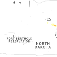


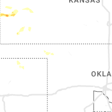

Cities Most Affected by Hail Storms of 7/2/2023
| Hail Size | Demographics of Zip Codes Affected | ||||||
|---|---|---|---|---|---|---|---|
| City | Count | Average | Largest | Pop Density | House Value | Income | Age |
| Lamar, CO | 1 | 2.00 | 2.00 | 13 | $72k | $30.3k | 35.8 |
| Edinburgh, IN | 1 | 2.00 | 2.00 | 127 | $94k | $37.8k | 39.2 |
| Syracuse, KS | 1 | 2.00 | 2.00 | 0 | $62k | $31.6k | 32.3 |
| Fordsville, KY | 1 | 1.75 | 1.75 | 26 | $41k | $25.5k | 43.6 |
| Batesville, MS | 1 | 1.75 | 1.75 | 57 | $65k | $29.4k | 35.3 |
| Albion, IL | 1 | 1.75 | 1.75 | 34 | $54k | $32.8k | 42.2 |
Hail and Wind Damage Spotted on 7/2/2023
Filter by Report Type:Hail ReportsWind Reports
States Impacted
Missouri, Kentucky, Illinois, Virginia, Texas, Arkansas, Alabama, North Carolina, Indiana, Tennessee, Mississippi, Ohio, Georgia, Pennsylvania, Florida, Connecticut, Maryland, West Virginia, Colorado, Kansas, South Carolina, MontanaMissouri
| Local Time | Report Details |
|---|---|
| 9:02 AM CDT | Trees and powerlines down across the area. trees down on house in mississippi county MO, 47.2 miles SSE of Cape Girardeau, MO |
| 1:35 PM CDT | Corrects previous tstm wnd dmg report from 3 n patton. tree branches down on highway 5 in bollinger county MO, 30.9 miles WNW of Cape Girardeau, MO |
| 2:40 PM CDT | 60 mph estimated wind speed. tree limbs blown off. heavy rain and pea sized hai in cape girardeau county MO, 12.2 miles WSW of Cape Girardeau, MO |
| 3:56 PM CDT | Outdoor retailer had merchandize thrown. semi flipped in parking lo in scott county MO, 13.3 miles S of Cape Girardeau, MO |
Kentucky
| Local Time | Report Details |
|---|---|
| 9:29 AM CDT | Trees dow in carlisle county KY, 46.9 miles SE of Cape Girardeau, MO |
| 9:40 AM CDT | A few trees down in the count in mccracken county KY, 54.1 miles ESE of Cape Girardeau, MO |
| 12:29 PM CDT | Quarter sized hail reported near Cloverport, KY, 50.9 miles WSW of Louisville, KY |
| 12:35 PM CDT | Quarter sized hail reported near Philpot, KY, 39.9 miles ESE of Evansville, IN, report from mping: quarter (1.00 in.). |
| 12:45 PM CDT | Quarter sized hail reported near Hawesville, KY, 45.4 miles ESE of Evansville, IN, report from mping: quarter (1.00 in.). |
| 12:48 PM CDT | Tree down on bates hollow roa in hancock county KY, 47.2 miles ESE of Evansville, IN |
| 1:18 PM CDT | Golf Ball sized hail reported near Fordsville, KY, 52.3 miles ESE of Evansville, IN |
| 2:30 PM EDT | Trees down on powerlin in meade county KY, 25.6 miles W of Louisville, KY |
| 2:46 PM EDT | Tree down over roa in meade county KY, 22.2 miles WSW of Louisville, KY |
| 3:06 PM EDT | Multiple trees dow in bullitt county KY, 3.4 miles SSE of Louisville, KY |
| 3:06 PM EDT | Multiple trees and power lines down over the roa in bullitt county KY, 0.2 miles NW of Louisville, KY |
| 3:07 PM EDT | Tree on hous in bullitt county KY, 5.4 miles SE of Louisville, KY |
| 3:18 PM EDT | Trees dow in bullitt county KY, 9.7 miles E of Louisville, KY |
| 3:40 PM EDT | Quarter sized hail reported near Taylorsville, KY, 22.2 miles E of Louisville, KY |
| 3:40 PM EDT | Trees down over roa in spencer county KY, 20.8 miles E of Louisville, KY |
| 3:40 PM EDT | Roof blown off a bar in spencer county KY, 21.1 miles E of Louisville, KY |
| 3:42 PM EDT | Trees down over old state roa in meade county KY, 25.4 miles W of Louisville, KY |
| 3:47 PM EDT | Trees and powerlines dow in nelson county KY, 27.8 miles ESE of Louisville, KY |
| 3:48 PM EDT | Trees blown across roadways in the mount zion vicinit in grant county KY, 25.8 miles SSW of Cincinnati, OH |
| 3:50 PM EDT | Multiple trees dow in meade county KY, 24.8 miles W of Louisville, KY |
| 3:54 PM EDT | Emergency manager sent in a picture of a metal carport wrapped around a large tree that has been blown over and on the groun in meade county KY, 25 miles W of Louisville, KY |
| 3:58 PM EDT | Tree fallen on ca in anderson county KY, 35.9 miles E of Louisville, KY |
| 4:00 PM EDT | Trees down along route 17. time estimated from rada in pendleton county KY, 22.3 miles SSE of Cincinnati, OH |
| 4:01 PM EDT | Numerous trees down in and around the butler area. including along route 2 in pendleton county KY, 22.7 miles SSE of Cincinnati, OH |
| 4:02 PM EDT | Tree down on hwy 12 in anderson county KY, 46.2 miles E of Louisville, KY |
| 4:04 PM EDT | Roof blown off building and multiple trees dow in anderson county KY, 41.9 miles E of Louisville, KY |
| 4:06 PM EDT | Tree down near glensboro roa in anderson county KY, 41.9 miles E of Louisville, KY |
| 4:09 PM EDT | Tree down near south main stree in anderson county KY, 45.2 miles E of Louisville, KY |
| 4:10 PM EDT | Tree down near harrodsburg roa in anderson county KY, 45.7 miles E of Louisville, KY |
| 4:11 PM EDT | Treed down near wildcat roa in anderson county KY, 47.9 miles E of Louisville, KY |
| 4:14 PM EDT | Trees down over road in woodford county KY, 47.8 miles WNW of Irvine, KY |
| 4:16 PM EDT | Numerous trees down. time estimated from rada in bracken county KY, 26.4 miles SE of Cincinnati, OH |
| 4:16 PM EDT | Tree down on magnolia circl in woodford county KY, 48.5 miles WNW of Irvine, KY |
| 4:16 PM EDT | Tree down near huntertown roa in woodford county KY, 46.5 miles WNW of Irvine, KY |
| 4:18 PM EDT | Power pole dow in woodford county KY, 49.5 miles NW of Irvine, KY |
| 4:18 PM EDT | Tree dow in woodford county KY, 47.8 miles WNW of Irvine, KY |
| 4:24 PM EDT | Walnut tree snappe in fayette county KY, 36.8 miles WNW of Irvine, KY |
| 4:26 PM EDT | Multiple trees dow in woodford county KY, 48.1 miles WNW of Irvine, KY |
| 4:28 PM EDT | Trees down on tates creek r in fayette county KY, 33.9 miles WNW of Irvine, KY |
| 4:28 PM EDT | Trees down on nicholasville r in fayette county KY, 35.6 miles WNW of Irvine, KY |
| 4:30 PM EDT | Storm damage reported in fayette county KY, 41.9 miles NW of Irvine, KY |
| 4:30 PM EDT | Multiple trees down on roa in fayette county KY, 35.1 miles WNW of Irvine, KY |
| 4:32 PM EDT | Tree down in yar in fayette county KY, 37.5 miles NW of Irvine, KY |
| 4:32 PM EDT | Tree on roa in fayette county KY, 35.5 miles WNW of Irvine, KY |
| 4:33 PM EDT | Tree down near nicholasville roa in fayette county KY, 36 miles WNW of Irvine, KY |
| 4:34 PM EDT | Tree down on roa in woodford county KY, 47.8 miles NW of Irvine, KY |
| 4:35 PM EDT | Tree down near tates creek roa in fayette county KY, 32.6 miles WNW of Irvine, KY |
| 4:35 PM EDT | Tree down near man o war blv in fayette county KY, 33.3 miles NW of Irvine, KY |
| 4:36 PM EDT | Uprooted tre in fayette county KY, 33.2 miles NW of Irvine, KY |
| 3:37 PM CDT | Estimated wind gust of 60 mph. report from mping: trees uprooted or snappe in daviess county KY, 27.7 miles ESE of Evansville, IN |
| 4:39 PM EDT | Multiple trees down near andover hil in fayette county KY, 32 miles NW of Irvine, KY |
| 4:40 PM EDT | Tree down on normans camp roa in mercer county KY, 41.5 miles W of Irvine, KY |
| 4:54 PM EDT | Multiple trees dow in clark county KY, 21.7 miles NW of Irvine, KY |
| 4:54 PM EDT | Trees down over multiple road in clark county KY, 22.9 miles NNW of Irvine, KY |
| 3:58 PM CDT | Quarter sized hail reported near Lewisport, KY, 40.7 miles E of Evansville, IN |
| 4:10 PM CDT | Quarter sized hail reported near Calhoun, KY, 30 miles SSE of Evansville, IN, report from mping: quarter (1.00 in.). |
| 4:22 PM CDT | Estimated 60 mph wind. large tree limbs down. penny sized hail. report from mpin in daviess county KY, 40.9 miles ESE of Evansville, IN |
| 5:40 PM EDT | Quarter sized hail reported near Frenchburg, KY, 26.4 miles NE of Irvine, KY, county em reported quarter size hail starting at the intersection of 460 and ky-36 and running northeast to the intersection of ky-36 and old beaver rd. |
| 4:42 PM CDT | Estimated 65 mph wind speed. report from mping: trees uprooted or snapped in daviess county KY, 40.9 miles ESE of Evansville, IN |
| 6:00 PM EDT | Images of a tree over powerlines and a house on castle drive. 911 call center reported the tree over the powerlines later caught fire. power was turned off for around 1 in rowan county KY, 50.5 miles NE of Irvine, KY |
| 5:07 PM CDT | Large tree limbs dow in mccracken county KY, 48.9 miles ESE of Cape Girardeau, MO |
| 6:12 PM EDT | 911 call center had reports of trees down at the intersection of lacy creek rd and highway 364. time estimated by rada in morgan county KY, 45.2 miles ENE of Irvine, KY |
| 6:20 PM EDT | 911 call center had a report of a tree down at the end of gifford rd at 460 n. time estimated by rada in magoffin county KY, 47 miles E of Irvine, KY |
| 6:29 PM EDT | Trees dow in greenup county KY, 73.7 miles WNW of Charleston, WV |
| 6:35 PM EDT | Several trees were blown down near 200 moore ridge road in the foxtown community. the event time is radar estimate in jackson county KY, 13.8 miles S of Irvine, KY |
| 6:38 PM EDT | Trees were blown onto powerlines in the stambaugh vicinity per a post to social media. the event time is radar estimate in johnson county KY, 65.1 miles ENE of Irvine, KY |
| 6:44 PM EDT | Trees down near 2000 salt rock roa in jackson county KY, 11.1 miles S of Irvine, KY |
| 6:48 PM EDT | A tree was blown into a powerline. the even time is radar estimate in floyd county KY, 66.6 miles E of Irvine, KY |
| 6:52 PM EDT | Trees were blown down onto a powerline leading to a fire in van lea in johnson county KY, 66.7 miles E of Irvine, KY |
| 6:55 PM EDT | Multiple trees and large limbs down on lake drive. the event time is radar estimate in floyd county KY, 67.2 miles E of Irvine, KY |
| 7:17 PM EDT | Trees down onto ky 292 in the warfield to lovely area. the event time is radar estimate in martin county KY, 55.3 miles SW of Charleston, WV |
| 7:24 PM EDT | Trees and limbs were reported to have been down in multiple locations along ky 292 from near warfield to the pike county line. the event time is radar estimate in martin county KY, 55.8 miles SW of Charleston, WV |
| 6:28 PM CDT | Damage to barn roof on marshall ridge roa in green county KY, 46.9 miles SSE of Louisville, KY |
| 6:38 PM CDT | Tree down on hidden valley roa in green county KY, 50.8 miles SSE of Louisville, KY |
| 6:39 PM CDT | Tree down on russell av in green county KY, 51.7 miles SSE of Louisville, KY |
| 7:54 PM EDT | Trees dow in lincoln county KY, 33.7 miles WSW of Irvine, KY |
| 7:56 PM EDT | Roof blown off hom in casey county KY, 58.6 miles SE of Louisville, KY |
| 8:15 PM EDT | Tree reported down over eades drive from the 911 call center. time estimated by rada in estill county KY, 4.2 miles N of Irvine, KY |
| 8:15 PM EDT | A tree was down on chestnut grove road in the chestnut grover community. the event time is radar estimate in rockcastle county KY, 29.4 miles SW of Irvine, KY |
| 8:18 PM EDT | A tree was blown down in brodhead. the event time is radar estimate in rockcastle county KY, 32 miles SW of Irvine, KY |
| 8:29 PM EDT | A tree was reported down on tipton ridge road. the event time is radar estimate in estill county KY, 6.3 miles E of Irvine, KY |
| 8:40 PM EDT | A tree was down on chestnut ridge road near the southside of mount vernon. the event time is radar estimate in rockcastle county KY, 31.2 miles SW of Irvine, KY |
| 8:40 PM EDT | Tree reported down over highway 1010 near mile marker 2. this would have been near the intersection of blackwater rd. time estimated by rada in morgan county KY, 31 miles ENE of Irvine, KY |
| 8:41 PM EDT | A tree was blown down on big cave road. the even time is radar estimate in rockcastle county KY, 30.9 miles SW of Irvine, KY |
| 8:46 PM EDT | A tree was blown down on south wilderness road. the event time is radar estimate in rockcastle county KY, 30.7 miles SSW of Irvine, KY |
| 8:50 PM EDT | Highway garage reported a tree down over highway 11 near mile marker 5. time estimated by rada in lee county KY, 17.1 miles ESE of Irvine, KY |
| 8:50 PM EDT | Highway garage reported a tree down on ky-1746 near 52. time estimated by rada in lee county KY, 10 miles ESE of Irvine, KY |
| 9:05 PM EDT | Tree reported down half way along ky 1162. time estimated by rada in morgan county KY, 42.3 miles ENE of Irvine, KY |
| 9:05 PM EDT | 911 call center reported a tree down over blankey branch road. time estimated by rada in lee county KY, 22 miles ESE of Irvine, KY |
| 9:06 PM EDT | A tree was blown down near 200 highway ky 29 in jackson county KY, 18.7 miles S of Irvine, KY |
| 9:10 PM EDT | Tree reported down over highway 364 just prior to the intersection of trace fork rd heading eastbound. time estimated by rada in morgan county KY, 47.7 miles ENE of Irvine, KY |
| 9:42 PM EDT | A tree was reported to have been down on ky 1098 about 2 miles from ky 1 in breathitt county KY, 37.3 miles ESE of Irvine, KY |
| 10:31 PM EDT | A tree was blown down along ky 7 near the letcher elementary and middle school. the event time is radar estimate in letcher county KY, 55 miles NW of Bristol, TN |
| 10:38 PM EDT | A tree was blown on malvin hill church road near ky 80. the event time is radar estimate in pulaski county KY, 51 miles SSW of Irvine, KY |
| 10:49 PM EDT | A tree was blown down on ky 11 in the garrard area near manchester. the event time is radar estimate in clay county KY, 41.9 miles SSE of Irvine, KY |
| 10:52 PM EDT | A tree was blown down on sandy gap near the intersection with ky 80. the event time is radar estimate in pulaski county KY, 42.1 miles SSW of Irvine, KY |
| 10:57 PM EDT | A large tree limb was reported to be down near 200 riverbend road. the event time is radar estimate in laurel county KY, 44.5 miles S of Irvine, KY |
| 11:22 PM EDT | A tree was reported to be down near 8000 ky 11 south. the event time is radar estimate in clay county KY, 46.4 miles SSE of Irvine, KY |
| 11:23 PM EDT | A tree was reported down on ky 472 in the fogertown communit in clay county KY, 33.4 miles S of Irvine, KY |
| 11:30 PM EDT | A tree was down along us 421 near the clay and jackson county line near shepherdtow in clay county KY, 28.2 miles SSE of Irvine, KY |
| 11:35 PM EDT | A tree was blown down onto ky 149 near hector. the event time is radar estimate in clay county KY, 41.9 miles SSE of Irvine, KY |
| 11:36 PM EDT | 2 trees were blown down along ky 223 near escoes market with one onto a powerline causing a fire. the event time is radar estimate in knox county KY, 58.6 miles SSE of Irvine, KY |
| 11:40 PM EDT | A tree was reported to have been blown down on 1st stree in clay county KY, 34.6 miles SSE of Irvine, KY |
Illinois
| Local Time | Report Details |
|---|---|
| 10:36 AM CDT | Via email with pictures included: trees snapped in are in madison county IL, 12.5 miles ENE of Saint Louis, MO |
| 1:15 PM CDT | Storm damage reported in williamson county IL, 42.6 miles NE of Cape Girardeau, MO |
| 1:20 PM CDT | 6 homes damaged... power poles snapped... large tree branches snapped... 600-700 people without powe in williamson county IL, 46.9 miles NE of Cape Girardeau, MO |
| 1:40 PM CDT | Several large limbs down. large oak tree on drivewa in saline county IL, 57.4 miles W of Evansville, IN |
| 1:42 PM CDT | Quarter sized hail reported near New Haven, IL, 31.4 miles W of Evansville, IN, relayed from the media. |
| 1:50 PM CDT | Estimated 65 mph. large branches blown dow in saline county IL, 55.8 miles WSW of Evansville, IN |
| 1:51 PM CDT | Half Dollar sized hail reported near Marion, IL, 43.7 miles NE of Cape Girardeau, MO, report from mping: half dollar (1.25 in.). |
| 1:55 PM CDT | Wooden fence blown over. tree on hous in saline county IL, 55.8 miles WSW of Evansville, IN |
| 2:00 PM CDT | Corrects previous tstm wnd dmg report from norris city. trees and tree limbs down... damage to gate. estimated 65 mp in white county IL, 41.8 miles W of Evansville, IN |
| 2:00 PM CDT | Corrects previous tstm wnd dmg report from norris city. trees and tree limbs down... damage to gate. estimated 65 mp in white county IL, 41.8 miles W of Evansville, IN |
| 2:18 PM CDT | Quarter sized hail reported near Carbondale, IL, 33.9 miles NNE of Cape Girardeau, MO, report from mping: quarter (1.00 in.). |
| 2:20 PM CDT | Tree down on il hwy in gallatin county IL, 44.2 miles WSW of Evansville, IN |
| 2:32 PM CDT | Report from mping: tree limbs broken; power poles broke in williamson county IL, 44.3 miles NE of Cape Girardeau, MO |
| 2:45 PM CDT | Large branches down. one shoved into the ground. 65 mph estimated wind spee in franklin county IL, 52.4 miles NE of Cape Girardeau, MO |
| 3:30 PM CDT | Corrects previous tstm wnd dmg report from 1 se new columbia. large tree branches blown down. several trees dow in massac county IL, 43.2 miles E of Cape Girardeau, MO |
| 3:30 PM CDT | Corrects previous tstm wnd dmg report from 1 se new columbia. large tree branches blown down. several trees dow in massac county IL, 43.2 miles E of Cape Girardeau, MO |
| 3:34 PM CDT | Tree blown down. outbuildings los in massac county IL, 44.5 miles E of Cape Girardeau, MO |
| 3:36 PM CDT | Multiple tree branches scattered around... some larg in massac county IL, 44.5 miles E of Cape Girardeau, MO |
| 3:36 PM CDT | Tree limb down on power line in massac county IL, 46 miles ESE of Cape Girardeau, MO |
| 4:35 PM CDT | Golf Ball sized hail reported near Albion, IL, 38.8 miles NW of Evansville, IN |
| 4:37 PM CDT | Quarter sized hail reported near Albion, IL, 38.8 miles NW of Evansville, IN |
| 4:54 PM CDT | Pole bent ove in massac county IL, 44.5 miles E of Cape Girardeau, MO |
| 5:00 PM CDT | Corrects previous tstm wnd dmg report from 1 se new columbia. large tree branches blown down. several trees dow in massac county IL, 43.2 miles E of Cape Girardeau, MO |
Virginia
| Local Time | Report Details |
|---|---|
| 1:40 PM EDT | Large tree down near the intersection of deshazo road and turkey trott trail. both lanes of the deshazo road were blocked. the downed tree also brought down a power lin in henry county VA, 49.8 miles S of Roanoke, VA |
| 1:42 PM EDT | Two trees down on u.s. highway 220 or greensboro road in the ridgeway are in henry county VA, 49.1 miles S of Roanoke, VA |
| 1:45 PM EDT | Tree down just 0.5 mile north of the north carolina state line in the north bound lane of u.s. 220 or greensboro roa in henry county VA, 47.2 miles S of Roanoke, VA |
| 1:45 PM EDT | Tree down in the 300 block of pratt road near its intersection of spencer moores mil in henry county VA, 49.2 miles S of Roanoke, VA |
| 1:50 PM EDT | Tree down in the 90th block of elijah circle on the northeast side of martinsville near its intersection with chatham road. entire road blocked by the downed tre in henry county VA, 38.5 miles SSE of Roanoke, VA |
| 1:55 PM EDT | Three trees down in the 600 block of axton road at the location of a large curve in the roa in henry county VA, 44.7 miles SSE of Roanoke, VA |
| 1:58 PM EDT | Large tree down blocking both lanes of axton road in the 2900 bloc in henry county VA, 46.2 miles SSE of Roanoke, VA |
| 2:03 PM EDT | Tree down at the intersection of friendly road and axton road in the far southeast corner of henry count in henry county VA, 51.1 miles SSE of Roanoke, VA |
| 2:20 PM EDT | One-inch tree limbs broken; shingles blown of in pittsylvania county VA, 48.6 miles SE of Roanoke, VA |
| 2:47 PM EDT | Multiple trees down in the vernon hill area of western halifax count in halifax county VA, 58.8 miles SE of Roanoke, VA |
| 3:05 PM EDT | Trees and limbs down in south bosto in halifax county VA, 64.7 miles NNW of Raleigh, NC |
| 3:20 PM EDT | Numerous power outages reported along hitesburg road due to downed tree limbs. time radar estimate in mecklenburg county VA, 55.6 miles N of Raleigh, NC |
| 3:35 PM EDT | Several trees and power lines down from buffalo junction to clarksville. time estimated from radar dat in mecklenburg county VA, 57.7 miles N of Raleigh, NC |
| 12:01 AM EDT | A tree fell down near the 1500 block of falling rock d in nelson county VA, 61.1 miles ENE of Roanoke, VA |
| 12:02 AM EDT | A tree fell and brought down a powerline near the 3600 block of phoenix r in nelson county VA, 63.1 miles ENE of Roanoke, VA |
| 12:02 AM EDT | A tree fell down near phoenix rd and arrizona l in nelson county VA, 63.4 miles ENE of Roanoke, VA |
| 12:04 AM EDT | A tree fell down near variety mills rd and norwood r in nelson county VA, 64.3 miles W of Richmond, VA |
Texas
| Local Time | Report Details |
|---|---|
| 12:42 PM CDT | Trees down and power outages in newsome from a thunderstor in camp county TX, 87.2 miles WNW of Shreveport, LA |
| 4:27 PM CDT | Storm damage reported in dallam county TX, 93.7 miles NNE of Tucumcari, NM |
| 6:12 PM CDT | Storm damage reported in moore county TX, 43.3 miles N of Amarillo, TX |
| 6:52 PM CDT | Storm damage reported in oldham county TX, 29.3 miles W of Amarillo, TX |
| 7:15 PM CDT | Storm damage reported in deaf smith county TX, 36.9 miles SW of Amarillo, TX |
| 7:39 PM CDT | Storm damage reported in carson county TX, 17.8 miles ENE of Amarillo, TX |
| 9:07 PM CDT | Severe wind gusts for four minutes from 907 pm to 910 pm. 70 mph was the strongest gus in hockley county TX, 21.5 miles WNW of Lubbock, TX |
Arkansas
| Local Time | Report Details |
|---|---|
| 12:45 PM CDT | Quarter sized hail reported near Corning, AR, 83.2 miles SW of Cape Girardeau, MO, public report of quarter sized hail. |
Alabama
| Local Time | Report Details |
|---|---|
| 12:50 PM CDT | Quarter sized hail reported near New Market, AL, 66.6 miles E of Florence, AL, quarter sized hail at 376 charlie patterson road. |
| 2:07 PM CDT | Half Dollar sized hail reported near Bankston, AL, 54.9 miles WNW of Birmingham, AL |
| 2:09 PM CDT | Trees and power lines dow in walker county AL, 21 miles NW of Birmingham, AL |
| 2:10 PM CDT | Trained spotter measured 60mph wind gust in stevenson on broad stree in jackson county AL, 31.9 miles WSW of Chattanooga, TN |
| 2:12 PM CDT | Large tree onto a house in court in jefferson county AL, 8.8 miles SW of Birmingham, AL |
| 2:17 PM CDT | Trees and tree limbs down... canopies tossed about at river rocks campgroun in etowah county AL, 56.8 miles NE of Birmingham, AL |
| 2:17 PM CDT | Baron station. height of sensor unknow in etowah county AL, 54 miles NE of Birmingham, AL |
| 2:17 PM CDT | Numerous trees down in the gadsden area... several onto residences causing significant damag in etowah county AL, 55.7 miles NE of Birmingham, AL |
| 2:21 PM CDT | Trees and large tree limbs blown down at various locations around gadsden... a few taking down power poles/lines. gas station canopy toppled at mars shaved ic in etowah county AL, 57.2 miles NE of Birmingham, AL |
| 2:22 PM CDT | Report of trees and power lines down near riverside. one tree on a home on depot s in st. clair county AL, 35.9 miles E of Birmingham, AL |
| 2:40 PM CDT | Tree blown down onto a car. unknown injury status of occupants. time of occurrence estimate in jefferson county AL, 4.8 miles SW of Birmingham, AL |
| 2:57 PM CDT | Tree down on county road 59 near county road 5 in dale county AL, 76.4 miles S of Auburn, AL |
| 3:00 PM CDT | A couple trees down in the centre are in cherokee county AL, 63.8 miles SSW of Chattanooga, TN |
| 3:05 PM CDT | Tree down in the skipperville area near the methodist church via scanne in dale county AL, 73.7 miles S of Auburn, AL |
| 3:06 PM CDT | Trees down and some tin pieces torn off of a barn on cr 122/197 near henage in dekalb county AL, 41.1 miles SW of Chattanooga, TN |
| 3:07 PM CDT | Dale county dispatch reports a tree down near the intersection of cr 20 and cr 3 in dale county AL, 78.5 miles S of Auburn, AL |
| 3:09 PM CDT | A tree was knocked down along highway 40 between highway 75 and the jackson county lin in dekalb county AL, 38.5 miles SW of Chattanooga, TN |
| 3:33 PM CDT | A couple trees down in the broomtown are in cherokee county AL, 48.8 miles SSW of Chattanooga, TN |
| 3:41 PM CDT | Half Dollar sized hail reported near Rainsville, AL, 48.5 miles SW of Chattanooga, TN |
| 3:42 PM CDT | Trees down in the 2000 block of cr 94 in fyff in dekalb county AL, 50.5 miles SW of Chattanooga, TN |
| 3:42 PM CDT | Cr 563: tree down on a home near fyffe... a in dekalb county AL, 50.4 miles SW of Chattanooga, TN |
| 3:44 PM CDT | A tree was knocked down at cr 92 near cr 47 near fyff in dekalb county AL, 52.1 miles SW of Chattanooga, TN |
| 3:44 PM CDT | Roof damage at a residence at cr 124 at cr 44 in jackson county AL, 45.9 miles SW of Chattanooga, TN |
| 3:44 PM CDT | Large tree limbs and a window blown out in the 2900 block of cr 19 in dutto in jackson county AL, 47.7 miles SW of Chattanooga, TN |
| 3:44 PM CDT | Widespread power outages and multiple trees down in the hodge community in dutto in jackson county AL, 47.2 miles SW of Chattanooga, TN |
| 3:45 PM CDT | Quarter sized hail reported near Harvest, AL, 51.5 miles E of Florence, AL, up to quarter sized hail off pine grove road west of wall triana. |
| 3:54 PM CDT | Trees dow in talladega county AL, 34.7 miles SE of Birmingham, AL |
| 3:56 PM CDT | Quarter sized hail reported near Huntsville, AL, 56 miles E of Florence, AL, near the intersection of douglass rd and indian creek road. |
| 3:57 PM CDT | Large tree down across childersburg fayetteville hwy near cosper bend. time estimate in talladega county AL, 30.3 miles SE of Birmingham, AL |
| 3:57 PM CDT | Quarter sized hail reported near Huntsville, AL, 57.2 miles E of Florence, AL, quarter size hail reported by the intersection of research park blvd and highway 53. |
| 4:06 PM CDT | Large trees down blocking cr 8 in randolph county AL, 59 miles N of Auburn, AL |
| 4:14 PM CDT | A tree was knocked down at 10780 mt hester road. time estimated by rada in colbert county AL, 21 miles WSW of Florence, AL |
| 4:19 PM CDT | A tree was knocked down on highway 72 at mile marker 2. time estimated by rada in colbert county AL, 22.6 miles W of Florence, AL |
| 4:27 PM CDT | A tree was knocked down at frankfort road at baker lane. time estimated by rada in colbert county AL, 8.5 miles SSW of Florence, AL |
| 4:30 PM CDT | A tree was knocked down on willow drive at jackson highway. time estimated by rada in colbert county AL, 14.5 miles S of Florence, AL |
| 4:34 PM CDT | A tree was knocked down at 2475 colburn mill road. time estimated by rada in colbert county AL, 15.3 miles S of Florence, AL |
| 4:37 PM CDT | A tree was knocked down at 100 west 5th street. time estimated by rada in colbert county AL, 3.1 miles SSW of Florence, AL |
| 4:41 PM CDT | Trees blown down on the east side of wedowe in randolph county AL, 48.4 miles N of Auburn, AL |
| 4:50 PM CDT | Trees down on cr 42 at reed street in hollywoo in jackson county AL, 43.7 miles WSW of Chattanooga, TN |
| 4:56 PM CDT | Henagar fd reports trees down on two homes in the area of the 5000 block of cr 122. multiple trees down in the same are in dekalb county AL, 40.8 miles SW of Chattanooga, TN |
| 5:15 PM CDT | Enterprise dispatch reports a power line down on hwy 27 n near cr 15 in coffee county AL, 76.3 miles NNE of Miramar Beach, FL |
| 6:03 PM CDT | Trees down and some tin pieces torn off of a barn on cr 122/197 near henage in dekalb county AL, 41.1 miles SW of Chattanooga, TN |
| 6:12 PM CDT | Trees downed at a few locations in eastern lee county... some onto roadways and power line in lee county AL, 23.9 miles E of Auburn, AL |
| 6:23 PM CDT | Montgomery pd comms center reports trees down at multiple locations across the city. at least one tree onto a hous in montgomery county AL, 51.3 miles WSW of Auburn, AL |
| 6:45 PM CDT | Trees and power lines down at various locations across wetumpk in elmore county AL, 41.6 miles W of Auburn, AL |
| 6:52 PM CDT | Trees and power lines dow in elmore county AL, 42.5 miles W of Auburn, AL |
North Carolina
| Local Time | Report Details |
|---|---|
| 1:58 PM EDT | Thunderstorm wind blew a tree down at the intersection of tayler road and dudley driv in rockingham county NC, 54.7 miles S of Roanoke, VA |
| 1:58 PM EDT | Thunderstorm winds blew tree limbs down at the intersection of stone mountain road and nc highway 13 in rockingham county NC, 58.1 miles S of Roanoke, VA |
| 2:01 PM EDT | Thunderstorm winds blew a tree and a power line down within the 2800 block of price grange roa in rockingham county NC, 53.5 miles S of Roanoke, VA |
| 2:07 PM EDT | Thunderstorm winds blew down a large tree within the 500 block of nc highway 700... ridgeway roa in rockingham county NC, 51.9 miles S of Roanoke, VA |
| 2:15 PM EDT | Tree down at the intersection of settlebridge road and goldfinch road near wentwort in rockingham county NC, 60.7 miles S of Roanoke, VA |
| 2:36 PM EDT | Large tree limb down on walters mill roa in caswell county NC, 61.6 miles SSE of Roanoke, VA |
| 2:39 PM EDT | Thunderstorm winds blew a tree down within the 200 block of burton roa in rockingham county NC, 61.4 miles SSE of Roanoke, VA |
| 3:23 PM EDT | Trees down on gravatte road and on halifax roads just northeast of roxbor in person county NC, 46.6 miles NNW of Raleigh, NC |
| 3:48 PM EDT | Numerous reports of trees and power lines down throughout northern vance county... including around townsvill in vance county NC, 50.1 miles NNE of Raleigh, NC |
| 3:52 PM EDT | Multiple trees dow in warren county NC, 49.7 miles NNE of Raleigh, NC |
| 3:52 PM EDT | Power outage caused by fallen trees on equipmen in vance county NC, 46.5 miles NNE of Raleigh, NC |
| 5:06 PM EDT | Quarter sized hail reported near Marshall, NC, 59.5 miles SSW of Bristol, TN, nickel to quarter size hail fell for approximately 3 minutes in marshall. |
| 5:31 PM EDT | Trees down on nc 9 in edgecombe county NC, 64.3 miles ENE of Raleigh, NC |
| 6:17 PM EDT | Trees down on freeman town roa in rutherford county NC, 50.9 miles NNE of Greenville, SC |
| 6:17 PM EDT | Trees down on bills creek roa in rutherford county NC, 49.7 miles NNE of Greenville, SC |
| 6:18 PM EDT | Trees down on cove roa in rutherford county NC, 52.5 miles NE of Greenville, SC |
| 6:55 PM EDT | Ping Pong Ball sized hail reported near Banner Elk, NC, 38.9 miles SSE of Bristol, TN, ping pong ball size hail fell in the sugar mountain area with vehicles sustaining damage at a service station on nc 105. |
| 6:58 PM EDT | *** 1 inj *** individual injured by lightning and transported to hospita in avery county NC, 38.9 miles SE of Bristol, TN |
| 6:58 PM EDT | *** 2 inj *** tent blown over in campgroun in avery county NC, 40.4 miles SE of Bristol, TN |
| 7:36 PM EDT | Tree on a house on windswept driv in mcdowell county NC, 64.4 miles NNE of Greenville, SC |
| 7:50 PM EDT | Corrects previous tstm wnd dmg report from 5 nne otto. trees down on roadwa in macon county NC, 46.7 miles WNW of Greenville, SC |
| 7:50 PM EDT | Trees down on roadwa in macon county NC, 46.5 miles WNW of Greenville, SC |
| 8:50 PM EDT | Tree down on roadwa in polk county NC, 37.1 miles NE of Greenville, SC |
Indiana
| Local Time | Report Details |
|---|---|
| 2:24 PM EDT | Tree down on power line. time estimated from rada in ripley county IN, 35.5 miles W of Cincinnati, OH |
| 2:34 PM EDT | Corrects previous tstm wnd dmg report from 4 nnw milan. tree down on power line. time estimated from rada in ripley county IN, 35.5 miles W of Cincinnati, OH |
| 2:40 PM EDT | Corrects previous tstm wnd dmg report from 4 nnw milan. corrects previous tstm wnd dmg report from 4 nnw milan. tree down on power line. time estimated from rada in ripley county IN, 35.5 miles W of Cincinnati, OH |
| 1:45 PM CDT | Trees dow in perry county IN, 44.5 miles WNW of Louisville, KY |
| 2:58 PM EDT | Quarter sized hail reported near Vevay, IN, 38.7 miles SW of Cincinnati, OH |
| 3:05 PM EDT | Large tree limbs down. shared by broadcast meteorologist. also nickel sized hai in ripley county IN, 34.2 miles W of Cincinnati, OH |
| 3:26 PM EDT | Several tree limbs up to 5 inches in diameter on county lin in owen county IN, 39.4 miles WSW of Indianapolis, IN |
| 3:37 PM EDT | Four-inch diameter tree branch was blown off a tree just north of the high school. street flooding on indiana stree in morgan county IN, 15.9 miles SW of Indianapolis, IN |
| 2:46 PM CDT | Power lines and power poles blown dow in gibson county IN, 30.1 miles N of Evansville, IN |
| 3:51 PM EDT | Storm damage reported in marion county IN, 8.9 miles WSW of Indianapolis, IN |
| 3:55 PM EDT | Ttraffic lights out at east street and st. clair street in downtown indianapolis along with downed tree limbs and a couple of small trees nearly uprooted from thunderst in marion county IN, 0.9 miles N of Indianapolis, IN |
| 3:57 PM EDT | Storm damage reported in marion county IN, 0.2 miles N of Indianapolis, IN |
| 4:13 PM EDT | Quarter sized hail reported near Indianapolis, IN, 9.9 miles ESE of Indianapolis, IN, report from mping: quarter (1.00 in.). |
| 4:15 PM EDT | Quarter sized hail reported near Gosport, IN, 36.1 miles SW of Indianapolis, IN |
| 4:22 PM EDT | Dime size hai in hancock county IN, 14.2 miles ESE of Indianapolis, IN |
| 4:23 PM EDT | At state road 9 and cr 200s in hancock county a 6-inch healthy tree branch was blown down by thunderstorm winds. time estimated from radar. relayed from ham radi in shelby county IN, 27.4 miles SE of Indianapolis, IN |
| 4:23 PM EDT | At state road 9 and cr 200s in hancock county a 6-inch healthy tree branch was blown down by thunderstorm winds. time estimated from rada in hancock county IN, 20.8 miles E of Indianapolis, IN |
| 4:25 PM EDT | Storm damage reported in hancock county IN, 20.9 miles E of Indianapolis, IN |
| 4:32 PM EDT | Quarter sized hail reported near Seymour, IN, 55.9 miles S of Indianapolis, IN |
| 4:36 PM EDT | Several trees snapped in taylorsville. time estimated from rada in bartholomew county IN, 33.8 miles SSE of Indianapolis, IN |
| 4:36 PM EDT | *** 1 inj *** falling trees damaged five cars and one rv resulting in one injur in bartholomew county IN, 33.6 miles SSE of Indianapolis, IN |
| 4:44 PM EDT | Quarter sized hail reported near Edinburgh, IN, 29.8 miles SSE of Indianapolis, IN |
| 4:45 PM EDT | Hen Egg sized hail reported near Edinburgh, IN, 30.5 miles SSE of Indianapolis, IN, trained spotter measured a 2.00 inch hailstone in edinburgh. |
| 4:46 PM EDT | Social media report of large tree limbs down in spiceland. time estimated via rada in henry county IN, 38.1 miles E of Indianapolis, IN |
| 4:51 PM EDT | Quarter sized hail reported near Edinburgh, IN, 29.2 miles SSE of Indianapolis, IN, report from mping: quarter (1.00 in.). |
| 4:53 PM EDT | Several trees and powerlines were blown down in west central rush county from thunderstorm winds. the time is estimated from rada in rush county IN, 32.3 miles ESE of Indianapolis, IN |
| 3:53 PM CDT | Trees down near mt. pleasant are in perry county IN, 44.7 miles WNW of Louisville, KY |
| 4:55 PM EDT | Quarter sized hail reported near Edinburgh, IN, 30.3 miles SSE of Indianapolis, IN |
| 4:00 PM CDT | Trees dow in perry county IN, 44.5 miles W of Louisville, KY |
| 5:15 PM EDT | Trees and power lines downed. time estimated from rada in decatur county IN, 45.5 miles SE of Indianapolis, IN |
| 5:19 PM EDT | Corrects previous tstm wnd dmg report from 2 w grissom afb. tree onto power lines. multiple large branches dow in cass county IN, 61.7 miles N of Indianapolis, IN |
| 5:19 PM EDT | Numerous reports of trees down. many in connersville... but also through additional areas of the count in fayette county IN, 50.6 miles NW of Cincinnati, OH |
| 5:20 PM EDT | Tree limbs of unknown size downe in randolph county IN, 57.1 miles ENE of Indianapolis, IN |
| 5:25 PM EDT | Trees and large branches downed across the count in wayne county IN, 53.3 miles E of Indianapolis, IN |
| 5:31 PM EDT | Trees and large branches downed from abington to centerville to richmon in wayne county IN, 49.4 miles NNW of Cincinnati, OH |
| 6:25 PM EDT | Knox county em reports tree/powerlines down along schoolhouse road on the west side of vincenne in knox county IN, 45.7 miles N of Evansville, IN |
| 6:26 PM EDT | Knox county reports multiple trees down in sw vincenne in knox county IN, 47.2 miles N of Evansville, IN |
| 7:02 PM EDT | Storm damage reported in monroe county IN, 50.5 miles SSW of Indianapolis, IN |
| 7:05 PM EDT | Quarter sized hail reported near Bloomington, IN, 49 miles SSW of Indianapolis, IN |
Tennessee
| Local Time | Report Details |
|---|---|
| 2:09 PM CDT | Photo received via twitter of a tree blown down onto a car in the cracker barrel parking lot. time estimated on rada in coffee county TN, 54.5 miles NW of Chattanooga, TN |
| 2:20 PM CDT | Trees were blown down across the southern portions of the count in marion county TN, 22.8 miles W of Chattanooga, TN |
| 2:20 PM CDT | Several trees down near winchester and hacks cross roa in shelby county TN, 15.7 miles ESE of Memphis, TN |
| 2:23 PM CDT | Large tree dow in shelby county TN, 17.3 miles ESE of Memphis, TN |
| 4:14 PM EDT | Storm damage reported in hamilton county TN, 3.2 miles ENE of Chattanooga, TN |
| 4:15 PM EDT | Numerous reports of trees and power lines blown down around chattanoog in hamilton county TN, 3.2 miles ENE of Chattanooga, TN |
| 4:38 PM EDT | Report from mping: 3-inch tree limbs broken; power poles broken. trees uprooted or snapped. time estimated from rada in bradley county TN, 17.7 miles E of Chattanooga, TN |
| 5:52 PM EDT | Quarter sized hail reported near Knoxville, TN, 10.3 miles N of Knoxville, TN, call center employee reported nickel to quarter sized hail. |
| 5:56 PM EDT | Tree down at tazewell pike and gibbs road. time estimated from rada in knox county TN, 13 miles NNE of Knoxville, TN |
| 6:49 PM CDT | Large tree down near stewarts creek/almavill in rutherford county TN, 23.3 miles SSE of Nashville, TN |
| 7:04 PM CDT | Half Dollar sized hail reported near Smyrna, TN, 20.5 miles SE of Nashville, TN, photo sent in of half-dollar size hail that fell on almaville rd. in smyrna. time estimated on radar. |
| 7:04 PM CDT | Photo received via facebook of a large tree limb blown down. time estimated on rada in rutherford county TN, 28.6 miles SE of Nashville, TN |
| 8:19 PM CDT | Numerous trees down south of hwy 385... resulting in power outage in shelby county TN, 16.2 miles NE of Memphis, TN |
| 8:37 PM CDT | Large tree limb down on hwy 70... struck a vehicl in shelby county TN, 18.3 miles ENE of Memphis, TN |
| 11:31 PM CDT | Powerlines down on houston levee road just south of wolf river blv in shelby county TN, 18.5 miles ESE of Memphis, TN |
Mississippi
| Local Time | Report Details |
|---|---|
| 2:16 PM CDT | Tree downed on providence r in grenada county MS, 49.5 miles WNW of Starkville, MS |
| 3:10 PM CDT | Numerous trees and powerlines dow in lee county MS, 49.8 miles NNE of Starkville, MS |
| 3:22 PM CDT | Several trees and powerlines dow in itawamba county MS, 57.1 miles NNE of Starkville, MS |
| 3:42 PM CDT | Trees and powerlines down across batesvill in panola county MS, 58.1 miles S of Memphis, TN |
| 3:42 PM CDT | Golf Ball sized hail reported near Batesville, MS, 58.2 miles S of Memphis, TN |
| 4:03 PM CDT | Numerous trees and powerlines dow in lafayette county MS, 53 miles SSE of Memphis, TN |
| 4:15 PM CDT | Numerous trees and powerlines dow in marshall county MS, 51.1 miles SE of Memphis, TN |
| 5:29 PM CDT | Tree down on roa in tate county MS, 37.9 miles S of Memphis, TN |
| 6:00 PM CDT | Trees were downed along cr 35 north of carrollto in carroll county MS, 65.9 miles W of Starkville, MS |
| 8:20 PM CDT | A few trees downed in the area of ms hwy 13 and ms hwy 2 in simpson county MS, 37.4 miles SSE of Jackson, MS |
Ohio
| Local Time | Report Details |
|---|---|
| 3:22 PM EDT | Tree down on morgan road in whitewater township. time estimated from rada in hamilton county OH, 15.8 miles WNW of Cincinnati, OH |
| 3:45 PM EDT | Quarter sized hail reported near Cincinnati, OH, 11.5 miles NNE of Cincinnati, OH, nickel to quarter sized hail |
| 3:46 PM EDT | Report from mping: 3-inch tree limbs broken; power poles broke in hamilton county OH, 11 miles NW of Cincinnati, OH |
| 4:48 PM EDT | Tree on a house and car in ripley. numerous trees downed on route 52 between georgetown and riple in brown county OH, 43.8 miles SE of Cincinnati, OH |
| 4:50 PM EDT | Numerous trees and power lines down in western part of county... concentrated in ostrande in delaware county OH, 23.9 miles NNW of Columbus, OH |
| 5:01 PM EDT | Storm damage reported in delaware county OH, 22.7 miles NNW of Columbus, OH |
| 5:25 PM EDT | Several trees downed in the northern part of the county... especially in and near peebles. time estimated by rada in adams county OH, 59.9 miles E of Cincinnati, OH |
| 5:35 PM EDT | Numerous trees down across the western part of scioto county. time estimated by rada in scioto county OH, 72.6 miles ESE of Cincinnati, OH |
| 5:45 PM EDT | 6 inch diameter tree limb dow in butler county OH, 30.6 miles NNW of Cincinnati, OH |
| 5:49 PM EDT | A tree and several large tree limbs downed near lake lakengren. time estimated by rada in preble county OH, 43.5 miles N of Cincinnati, OH |
| 5:49 PM EDT | Numerous trees downed throughout the county... including some trees downed on homes. time estimated by rada in preble county OH, 37.6 miles NNW of Cincinnati, OH |
| 5:51 PM EDT | Portion of a barn blown onto state rte 122 between eaton and gratis. time estimated by rada in preble county OH, 43.4 miles N of Cincinnati, OH |
| 5:54 PM EDT | 6 inch tree limb knocked down. time estimated from rada in preble county OH, 40.4 miles NNW of Cincinnati, OH |
| 5:55 PM EDT | Trees and large branches dow in preble county OH, 46.3 miles N of Cincinnati, OH |
| 5:57 PM EDT | Tree down on columbus r in knox county OH, 35.6 miles NE of Columbus, OH |
| 6:00 PM EDT | Barn blown across the road. time estimated from rada in preble county OH, 36.8 miles N of Cincinnati, OH |
| 6:08 PM EDT | Numerous trees downed throughout the county... especially in greenville. time estimated by rada in darke county OH, 68.8 miles N of Cincinnati, OH |
| 6:08 PM EDT | One tree downed along carrs run road. powerlines also downed in the area. time estimated by rada in pike county OH, 63.4 miles S of Columbus, OH |
| 6:21 PM EDT | Trees and power lines were blown down in scattered areas across the count in miami county OH, 59.6 miles N of Cincinnati, OH |
| 6:35 PM EDT | A few stop signs blown down in the city of uhrichsvill in tuscarawas county OH, 71.4 miles W of Pittsburgh, PA |
| 6:53 PM EDT | Tree down in downtown leesville. time based off the rada in carroll county OH, 63.9 miles W of Pittsburgh, PA |
| 7:01 PM EDT | One large healthy branch downed along i-71 near florence avenue. time estimated by rada in hamilton county OH, 3.9 miles NNE of Cincinnati, OH |
| 7:10 PM EDT | Half Dollar sized hail reported near Cincinnati, OH, 3.8 miles ENE of Cincinnati, OH |
| 7:56 PM EDT | Report of trees down in area. time estimated based on rada in jefferson county OH, 38.1 miles W of Pittsburgh, PA |
| 8:00 PM EDT | Report of trees down in area. time estimated based on rada in jefferson county OH, 32.3 miles W of Pittsburgh, PA |
| 8:01 PM EDT | Report of a few trees down in the area. time estimated based on rada in jefferson county OH, 34.7 miles W of Pittsburgh, PA |
| 8:05 PM EDT | Several large trees downed. time estimate in franklin county OH, 7.7 miles ENE of Columbus, OH |
| 8:18 PM EDT | Large tree downed. time estimated by rada in licking county OH, 17.9 miles E of Columbus, OH |
| 9:09 PM EDT | Tree dow in cuyahoga county OH, 9.9 miles ENE of Cleveland, OH |
| 9:14 PM EDT | Awos station kcgf clevlnd cuyahog in cuyahoga county OH, 12.3 miles ENE of Cleveland, OH |
Georgia
| Local Time | Report Details |
|---|---|
| 3:35 PM EDT | Quarter sized hail reported near Augusta, GA, 6.6 miles SW of Augusta, GA, relayed by media... a viewer reported quarter size hail near the intersection of richmond hill rd and windsor spring rd. |
| 3:35 PM EDT | Trees down near the intersection of ballard rd and new home r in dade county GA, 14.2 miles WSW of Chattanooga, TN |
| 3:49 PM EDT | Tree down along murphey hollow road near ferndale branch cree in dade county GA, 12 miles WSW of Chattanooga, TN |
| 3:50 PM EDT | Tree down at harris rd near reeves r in dade county GA, 11.7 miles SW of Chattanooga, TN |
| 4:45 PM EDT | Multiple trees down along old holland rd between southern 2 entrances to ga 10 in chattooga county GA, 50.2 miles S of Chattanooga, TN |
| 4:47 PM EDT | Tree down at hwy 100 and holland chattoogaville r in chattooga county GA, 48.1 miles S of Chattanooga, TN |
| 4:47 PM EDT | Tree and powerlines down at oak hill rd and mosley springs r in chattooga county GA, 45.6 miles SSW of Chattanooga, TN |
| 4:49 PM EDT | Tree down at reynolds st between williams st and cemetery r in chattooga county GA, 44.2 miles S of Chattanooga, TN |
| 4:54 PM EDT | Quarter sized hail reported near Lithia Springs, GA, 12.1 miles W of Atlanta, GA, 1 inch hail reported on thornton rd near i-20. |
| 4:54 PM EDT | Tree down at long hollow rd and browns r in chattooga county GA, 31.5 miles S of Chattanooga, TN |
| 4:54 PM EDT | Tree down on cox rd near back berryton r in chattooga county GA, 42.1 miles S of Chattanooga, TN |
| 4:54 PM EDT | Tree down on oak hill rd near smallen r in chattooga county GA, 44.4 miles S of Chattanooga, TN |
| 4:59 PM EDT | Tree down on house at nw congress st and nw congress s in chattooga county GA, 38.4 miles S of Chattanooga, TN |
| 5:00 PM EDT | Tree down on powerlines on e washington st near college st and e penn s in chattooga county GA, 39.1 miles S of Chattanooga, TN |
| 5:03 PM EDT | Powerlines down at walmart near martha berry hwy and underwood d in chattooga county GA, 36.3 miles S of Chattanooga, TN |
| 5:03 PM EDT | Tree down at alexander rd and penn bridge r in chattooga county GA, 37 miles S of Chattanooga, TN |
| 5:07 PM EDT | Tree down on powerlines near oakdale rd and oakdale road s in cobb county GA, 7.6 miles NW of Atlanta, GA |
| 5:11 PM EDT | Trees down along monterey pkwy and cimarron pkw in fulton county GA, 14.6 miles N of Atlanta, GA |
| 5:15 PM EDT | 58 mph (50 kt) wind gust reported by the rmg asos at 5:15 pm ed in floyd county GA, 48.8 miles S of Chattanooga, TN |
| 5:38 PM EDT | Tree down on mt carmel church rd near briarfield r in murray county GA, 33.2 miles ESE of Chattanooga, TN |
| 5:38 PM EDT | Tree down at old hwy 411 near sugar hollow rd and hemphill r in murray county GA, 42.8 miles SE of Chattanooga, TN |
| 5:49 PM EDT | Tree down on long hollow rd near browns r in chattooga county GA, 32.2 miles S of Chattanooga, TN |
| 5:54 PM EDT | Tree down at trion teloga rd and bryant rd near teloga cree in chattooga county GA, 34.5 miles S of Chattanooga, TN |
| 6:24 PM EDT | Tree down at turner road between refuge rd and turner rd ex in pickens county GA, 47.7 miles N of Atlanta, GA |
| 6:37 PM EDT | Multiple trees down in the braselton and hoschton area in jackson county GA, 43.5 miles NE of Atlanta, GA |
| 7:30 PM EDT | Tree down on roadway causing power outag in habersham county GA, 62.4 miles WSW of Greenville, SC |
| 7:30 PM EDT | Multiple trees dow in habersham county GA, 61.1 miles WSW of Greenville, SC |
| 7:33 PM EDT | Tree down on rolling ridge r in habersham county GA, 52.7 miles WSW of Greenville, SC |
| 7:37 PM EDT | Worth county 911 reported a tree down in the medders/meadowood are in worth county GA, 59.8 miles W of Douglas, GA |
| 7:42 PM EDT | Tree down on roadwa in stephens county GA, 45.5 miles WSW of Greenville, SC |
| 7:45 PM EDT | Trees down on roadwa in stephens county GA, 40.1 miles SW of Greenville, SC |
| 7:45 PM EDT | Trees down on roadwa in stephens county GA, 39.2 miles SW of Greenville, SC |
| 7:45 PM EDT | Multiple trees down on warwoman roa in rabun county GA, 44.4 miles W of Greenville, SC |
| 7:45 PM EDT | Tree down on home off stornoway roa in rabun county GA, 46.2 miles W of Greenville, SC |
| 7:49 PM EDT | Trees down on roadwa in rabun county GA, 45.1 miles W of Greenville, SC |
| 7:50 PM EDT | Trees down on roadwa in rabun county GA, 43.8 miles W of Greenville, SC |
| 8:00 PM EDT | 6 trees down near the intersection of rush creek hwy and dan hendricks r in talbot county GA, 48.8 miles ENE of Auburn, AL |
| 8:30 PM EDT | Lowndes county dispatch reported a tree down on a house on e cranford ave in valdost in lowndes county GA, 51.3 miles SSW of Douglas, GA |
| 8:30 PM EDT | Lowndes county dispatch reported multiple trees down across the northern part of the count in lowndes county GA, 47.1 miles SSW of Douglas, GA |
| 8:32 PM EDT | Lee county dispatch reports a tree down on thundering springs r in lee county GA, 72.3 miles W of Douglas, GA |
| 9:12 PM EDT | Trees down and power pole on fire near the intersection of andrew lane and old douglas road. time of event approximated by radar imager in atkinson county GA, 11.6 miles S of Douglas, GA |
Pennsylvania
| Local Time | Report Details |
|---|---|
| 3:43 PM EDT | Reports of multiple wires down. time estimated by rada in juniata county PA, 43.1 miles ESE of State College, PA |
| 3:45 PM EDT | Reports of tree and wires down along rt.1 in perry county PA, 45.8 miles ESE of State College, PA |
| 3:50 PM EDT | Photos of tree with a snapped trunk. time estimated by rada in perry county PA, 48.3 miles ESE of State College, PA |
| 3:57 PM EDT | Reports of multiple trees down in upper paxton and mifflin townships. time estimated by rada in dauphin county PA, 55.1 miles ESE of State College, PA |
| 4:24 PM EDT | Rv flipped over and roof off of a flea market. time estimated by rada in union county PA, 53.1 miles ENE of State College, PA |
| 4:25 PM EDT | Rood off of just lite it fireworks. time estimated by rada in union county PA, 53.8 miles ENE of State College, PA |
| 4:30 PM EDT | Reports of a barn collapse. time estimated by rada in union county PA, 48.9 miles ENE of State College, PA |
| 4:38 PM EDT | Reports of multiple trees down in jackson township. time estimated by rada in dauphin county PA, 60.1 miles ESE of State College, PA |
| 4:38 PM EDT | Multiple poles down along with multiple trees down across lykens township. time estimated by rada in dauphin county PA, 59.8 miles ESE of State College, PA |
| 5:15 PM EDT | Tree down partially blocking roadwa in centre county PA, 4.2 miles NNE of State College, PA |
| 5:29 PM EDT | Tree down across the roa in schuylkill county PA, 61.3 miles SSW of Scranton, PA |
| 6:12 PM EDT | Report of 1 tree down in spring twp near rte 222. time estimated via rada in berks county PA, 77.3 miles SSW of Scranton, PA |
| 7:20 PM EDT | Tree down blocking 3/4 of harford r in susquehanna county PA, 29.8 miles N of Scranton, PA |
| 8:01 PM EDT | Report of small funnels around landenberg with tree limbs down... but no major tree damag in chester county PA, 56.1 miles NE of Baltimore, MD |
Florida
| Local Time | Report Details |
|---|---|
| 4:08 PM EDT | Taylor county dispatch reports a power line down on martin luther king ave in perr in taylor county FL, 47.1 miles ESE of Tallahassee, FL |
Connecticut
| Local Time | Report Details |
|---|---|
| 5:14 PM EDT | Rt 4 closed in burlington between rt 179 and river r in hartford county CT, 77.9 miles W of Providence, RI |
| 5:14 PM EDT | Correction: route 4 closed in burlington between rt 179 and river rd in farmington due to tree and wires dow in hartford county CT, 77.5 miles W of Providence, RI |
Maryland
| Local Time | Report Details |
|---|---|
| 6:32 PM EDT | Two trees down in the cylburn neighborhoo in baltimore city county MD, 4.9 miles NNW of Baltimore, MD |
| 6:44 PM EDT | Large tree down onto power lines snapping power pole and bringing down power lines at 8312 loch raven blvd in baltimore county MD, 7.2 miles NNE of Baltimore, MD |
| 6:45 PM EDT | Large tree onto power lines snapping power pole and bringing down power lines at 8515 pleasant plains rd in baltimore county MD, 7.2 miles NNE of Baltimore, MD |
| 7:16 PM EDT | At least five trees down in paseden in anne arundel county MD, 11.5 miles SSE of Baltimore, MD |
| 7:28 PM EDT | Multiple trees down from lake shore to arcadi in anne arundel county MD, 14.6 miles SSE of Baltimore, MD |
| 8:11 PM EDT | Report of 1 tree down on hammond street in centreville. time estimated via rada in queen anne's county MD, 33.4 miles ESE of Baltimore, MD |
West Virginia
| Local Time | Report Details |
|---|---|
| 7:09 PM EDT | Several trees dow in wayne county WV, 53.5 miles WSW of Charleston, WV |
| 7:45 PM EDT | Tree down on bridge roa in lincoln county WV, 25.5 miles W of Charleston, WV |
| 8:02 PM EDT | Tree down on belvue drive in the roa in putnam county WV, 21.4 miles WNW of Charleston, WV |
| 8:03 PM EDT | Tree down on kanawha terrac in kanawha county WV, 9.5 miles WNW of Charleston, WV |
| 8:06 PM EDT | Multiple trees down along culler road. time estimated based on rada in hancock county WV, 29.8 miles W of Pittsburgh, PA |
| 8:11 PM EDT | Tree down on bull creek roa in boone county WV, 25.4 miles SSW of Charleston, WV |
| 8:12 PM EDT | Tree down along bigson driv in boone county WV, 25.2 miles S of Charleston, WV |
| 8:14 PM EDT | Tree down blocking one lane on oakwood road prior to clark roa in kanawha county WV, 1.3 miles WSW of Charleston, WV |
| 8:16 PM EDT | Tree down blocking dunbar av in kanawha county WV, 4.6 miles WNW of Charleston, WV |
| 8:40 PM EDT | Tree down partially in road along us hwy 33 west & lower cedar roa in gilmer county WV, 55.3 miles W of Elkins, WV |
| 8:43 PM EDT | Trees and lines down on spruce run roa in gilmer county WV, 53.2 miles W of Elkins, WV |
| 8:45 PM EDT | Tree down at the intersection of spring street and walnut stree in gilmer county WV, 53.1 miles W of Elkins, WV |
| 8:48 PM EDT | Tree down across us hwy 3 in gilmer county WV, 48.4 miles W of Elkins, WV |
| 8:49 PM EDT | Tree down along ellis run roa in gilmer county WV, 48.4 miles W of Elkins, WV |
| 9:29 PM EDT | Tree across hall roa in upshur county WV, 19.5 miles WNW of Elkins, WV |
| 9:37 PM EDT | Tree down blocking kesling mill roa in upshur county WV, 16.2 miles WNW of Elkins, WV |
| 9:38 PM EDT | Tree and line down along king school house roa in upshur county WV, 19.5 miles WNW of Elkins, WV |
| 9:39 PM EDT | Lines and pole are down at the railroad tracks on marion street. one lane is blocke in upshur county WV, 20.6 miles W of Elkins, WV |
| 9:48 PM EDT | 2 trees down union roa in barbour county WV, 14.5 miles NW of Elkins, WV |
| 9:51 PM EDT | Tree blocking mill run roa in webster county WV, 40.9 miles SW of Elkins, WV |
| 1:00 AM EDT | Tree down on road across from mini park. time estimated from rada in greenbrier county WV, 49.3 miles NW of Roanoke, VA |
Colorado
| Local Time | Report Details |
|---|---|
| 5:18 PM MDT | Hen Egg sized hail reported near Lamar, CO, 98.4 miles W of Garden City, KS |
Kansas
| Local Time | Report Details |
|---|---|
| 7:00 PM CDT | Estimated a quick burst of 50-60 mph wind in logan county KS, 37.6 miles SSW of Colby, KS |
| 6:20 PM MDT | Quarter sized hail reported near Syracuse, KS, 52.3 miles W of Garden City, KS |
| 6:30 PM MDT | Hen Egg sized hail reported near Syracuse, KS, 47.9 miles W of Garden City, KS |
| 6:35 PM MDT | Ping Pong Ball sized hail reported near Syracuse, KS, 47.9 miles W of Garden City, KS, several fb posts of 1.0 to 1.5 inch. |
| 6:35 PM MDT | Quarter sized hail reported near Syracuse, KS, 47.9 miles W of Garden City, KS |
| 6:35 PM MDT | Awos station k3k3 syracus in hamilton county KS, 47.9 miles W of Garden City, KS |
| 8:30 PM CDT | Storm damage reported in kearny county KS, 22.7 miles WNW of Garden City, KS |
| 9:05 PM CDT | Report received of strong winds causing tree damage... sprinklers to be knocked over... and powerlines to be knocked down at location. time is estimated by radar imager in gove county KS, 48.8 miles SE of Colby, KS |
| 9:05 PM CDT | Mesonet station ovek1 gove 5se. 10m wind measuremen in gove county KS, 47.8 miles SE of Colby, KS |
South Carolina
| Local Time | Report Details |
|---|---|
| 8:03 PM EDT | Trees down in parking lo in oconee county SC, 34.9 miles WSW of Greenville, SC |
| 8:10 PM EDT | Multiple trees down... one on power line... one on parked vehicl in oconee county SC, 30 miles WSW of Greenville, SC |
| 8:18 PM EDT | Trees down on roadwa in oconee county SC, 19.5 miles WSW of Greenville, SC |
| 8:46 PM EDT | Lightning strike to house causing structure fir in anderson county SC, 15.9 miles SSW of Greenville, SC |
| 9:10 PM EDT | Trees down on apartment comple in greenville county SC, 10.8 miles ENE of Greenville, SC |
| 9:14 PM EDT | Power line down at redland rd and highway 1 in spartanburg county SC, 33.3 miles NE of Greenville, SC |
| 9:18 PM EDT | Large tree down at n pacolet rd and loop r in spartanburg county SC, 37.2 miles NE of Greenville, SC |
| 9:25 PM EDT | Trees on roadway at fish camp road at hill ci in spartanburg county SC, 44 miles ENE of Greenville, SC |
| 9:39 PM EDT | Large tree down on hickory drive at mission ci in spartanburg county SC, 29.8 miles ENE of Greenville, SC |
| 10:00 PM EDT | Trees on roadwa in spartanburg county SC, 39.2 miles ENE of Greenville, SC |
| 10:00 PM EDT | Trees down on power lin in spartanburg county SC, 36 miles ENE of Greenville, SC |
| 10:02 PM EDT | Multiple trees down at cowpens battleground par in cherokee county SC, 49.4 miles ENE of Greenville, SC |
| 10:05 PM EDT | Trees down on power line in spartanburg county SC, 36.1 miles E of Greenville, SC |
| 10:10 PM EDT | Trees down blocking roadway with power lines dow in cherokee county SC, 51.7 miles ENE of Greenville, SC |
| 11:02 PM EDT | Trees on roadwa in spartanburg county SC, 29.2 miles ENE of Greenville, SC |
Montana
| Local Time | Report Details |
|---|---|
| 8:00 PM MDT | Quarter sized hail reported near Roberts, MT, 41.2 miles SW of Billings, MT, pea to quarter size |
| 11:32 PM MDT | Quarter sized hail reported near Wyola, MT, 70.3 miles SE of Billings, MT |
Connect with Interactive Hail Maps